Background
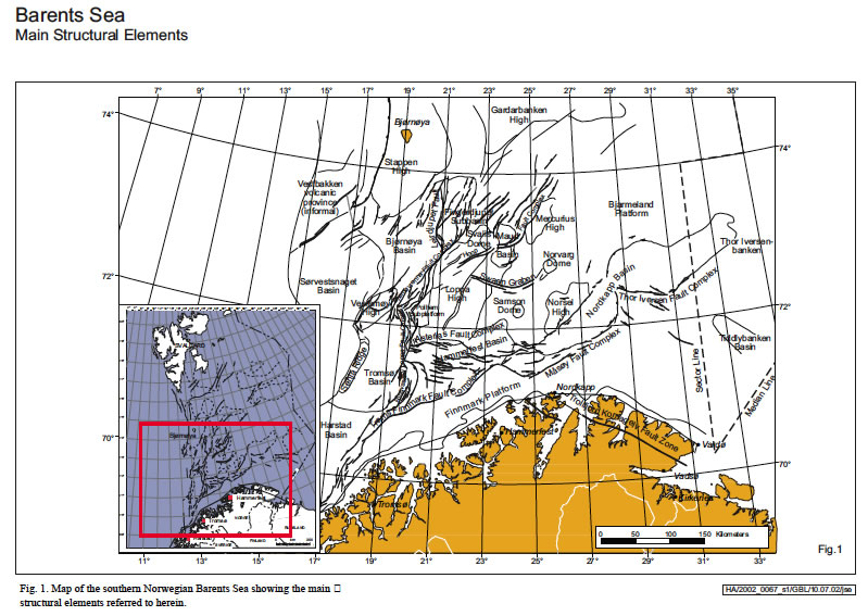
The Barents Sea covers a vast shelf area that extends from Novaya Zemlya in the east to the continental slope of the Norwegian-Greenland Sea in the west, and from Svalbard and Franz Josef Land in the north to the coasts of Norway and Russia in the south. The dividing line between Russia and Norway has not yet been resolved; Norwegian authorities suggest a midline division between the various Norwegian and Russian land areas and islands while the Russians favour a sector-based division generally extending from the mainland Russian/Norwegian border towards the North Pole (Fig. 1). The Barents Sea between the Norwegian coast and Svalbard comprises a continuous shelf area, mainly covered by thick Upper Palaeozoic to Tertiary sequences. Caledonian and earlier basement is only exposed along the Norwegian coast, on the island of Bjørnøya on the Stappen High and on and around the islands of Spitsbergen and Nordaustlandet on the northern Barents Shelf (Worsley et al. 1986; Harland 1997). At present most of the southern part of the Norwegian sector is open for commercial exploration; this comprises an area of about 240 000 km2, delimited to the north by the 74°30′ N latitude, to the south by 69°30′ N, with the baseline marking the limit of the Norwegian north coast; to the west, 16° eastern longitude marks the limit from 72° N to 74°30′ N. Because of availability of data this present study concentrates on the southern sector of the Norwegian Barents Sea, in itself almost double the size of the Norwegian North Sea. However, we will also make comparisons to timeequivalent sequences in the northern Barents Shelf, onland Svalbard, the Russian sector and northern Greenland and arctic Canada.
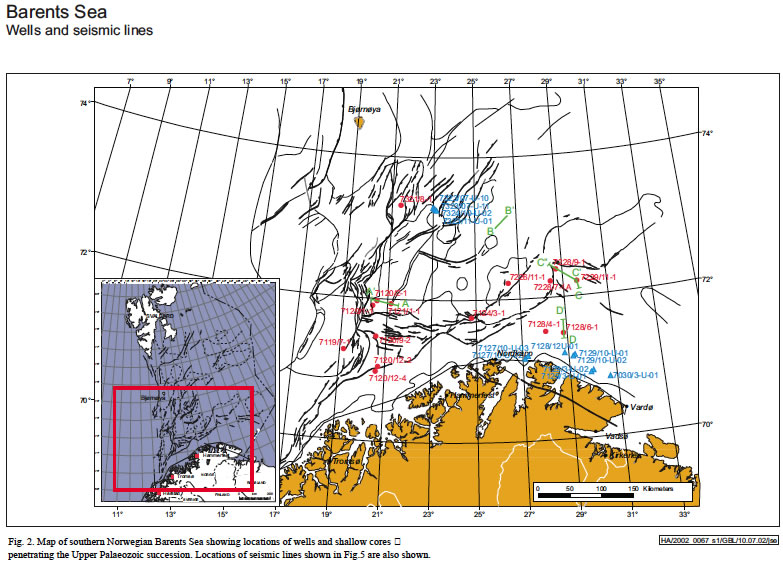
Geological exploration of the Norwegian Barents Shelf started with seismic surveys in the 1970s, resulting in the first differentiation of the province into a series of major subprovinces with a complex structural and sedimentological development (RГёnnevik et al. 1982; RГёnnevik & Jacobsen 1984; Faleide et al. 1984). Hydrocarbon exploration drilling started in 1980 and this ongoing exploration activity has resulted in a series of papers integrating regional well information with the steadily expanding seismic grid and pointing out the regional similarities of the geological development of Svalbard and both the Norwegian and Russian sectors of the Barents Shelf (e.g. Johansen et al. 1993; NГёttvedt et al. 1993). A total of 59 exploration wells have been drilled in the Norwegian Barents Sea, with more than half of these located in a relatively small area either in, or in close proximity to the Hammerfest Basin (Figs. 1 & 2). The remaining wells are spread across the shelf and have tested a variety of plays - 14 wells have drilled in-situ Upper Palaeozoic strata (Table 1), but only 6 of these had the Upper Palaeozoic succession as a primary or additional target. In most cases the coring programme was limited, an important exception being 7128/6-1 on the Finnmark Platform, which cored almost half of the 900 m thick Upper Palaeozoic section there (Ehrenberg et al. 1998a). In addition, the oil industry has financed IKU Petroleum Research1 to drill over 50 shallow stratigraphic boreholes (normally penetrating up to 200 metres into bedrock and giving a total of 3700 m of core) during the latter half of the 1980s. Eleven of these reached the Upper Palaeozoic succession (Table 1, see also Bugge et al. 1995). In addition to the well and core data, almost 400 000 kilometres of 2D seismic and 10 000 km2 of 3D seismic have been acquired in the southern Norwegian Barents Sea; these data, integrated with relevant wells and shallow cores, have permitted increasingly more sophisticated analyses and syntheses of the late Palaeozoic development of the area (Nilsen et al. 1993; Cecchi 1993; Gudlaugssen et al. 1994; Ehrenberg et al. 1998a,b, 2000, 2001, 2002; Elvebakk et al. 2002).
Two wells drilled in 1984/5 as a result of the 5th Concession Round were aimed at the Upper Palaeozoic succession of the Finnmark Platform margins, although this round’s main thrust was to explore the Mesozoic potential of the Hammerfest Basin. More emphasis was placed on the Upper Palaeozoic succession in the 9th Concession Round and this resulted in 3 wells on the southern margins of the Loppa High, drilled in 1985 and 1986. One of these (7120/2-1) had a significant oil column, although there has been much discussion as to whether unsuccessful testing suggested this was biodegraded “dead” oil (Knutsen et al. 2000) or that the carbonate reservoir was apparently tight and testing inadequate. Other wells drilled as a result of the drilling campaigns of the 5th to 12th concession rounds encountered or had TD in the Upper Palaeozoic, giving partial information on the upper parts of this succession. From the 11th Round in 1987 onwards the exploration area was extended to the entire southern sector of the Barents Sea, and especially in the 13th and 14th concession rounds in 1991 and 1993, play models with the Upper Palaeozoic succession as reservoir target were among the most important to be tested. A small gas and oil discovery was made in Upper Permian rocks in well 7128/4-1 drilled on the Finnmark Platform in 1993 and 7128/6-1 in the same area had oil shows in Upper Carboniferous carbonates. These finds, together with promising reservoir properties in older wells on the Finnmark Platform and the Loppa High, led the authorities to increase their expectations to the amount of undiscovered resources in the succession (NPD 1996). The Finnmark Platform and the Loppa High were therefore key exploration areas for the Upper Palaeozoic in the “Barents Sea Project”, a cooperative effort between the authorities and the oil industry, which resulted in 1997 in the awards of several large “seismic option areas”, where it was hoped that further work by the licensees would result in the future allocation of licences to drill exploration wells. No wells have yet been drilled in this ongoing exploration campaign, but well 7228/7-1 (13th Round) drilled in the Nordkapp Basin in 2000 encountered hydrocarbons in Triassic sandstones, apparently confirming the side-sealing capacity of Upper Palaeozoic salt diapirs in the Nordkapp Basin.