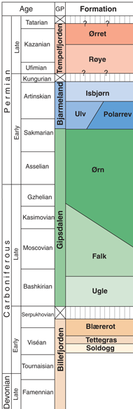
Tettegras Formation (Tettegrasformasjonen)
Name:
From the Norwegian name for the plant Butterwort (PinguГcula vulgГЎris).
Definition:
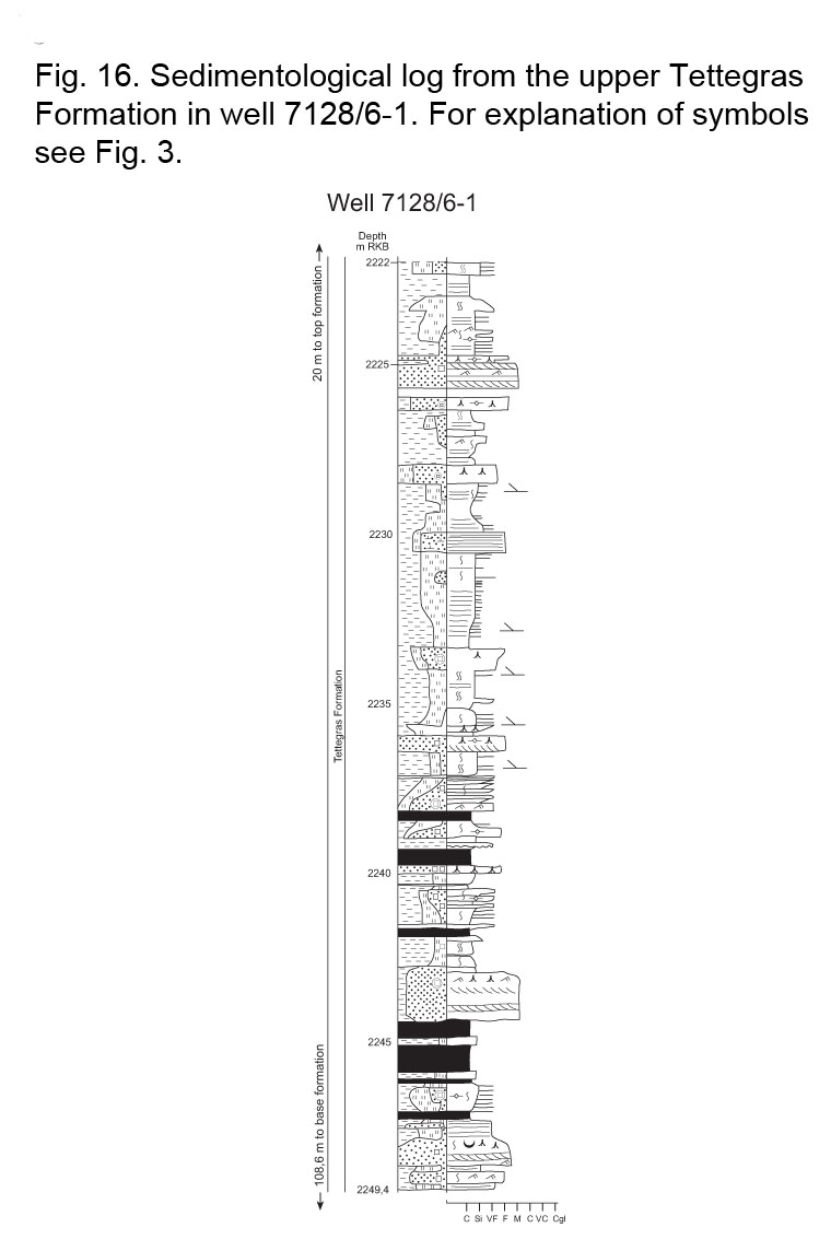
The type section is defined as the interval from 2358 m to 2202 m in well 7128/6-1 (Fig. 9; Table 1) and corresponds to the “Viséan coaly/shaly unit” of Ehrenberg et al. (1998a) in this well. One core, 27.4 m long, exists from the upper part of the formation (Fig. 16). The transition from the Soldogg Formation into the basal beds of the Tettegras Formation is defined by higher GR readings and overall a more rapidly changing GR curve, reflecting the transition from sandstones with rare siltstone and coal beds into rhythmically deposited sandstones, siltstones, claystones and coal.
Reference sections:
Reference sections are defined as the intervals from 2350.5 m to 2058 m in well 7128/4-1 (in contrast to Ehrenberg et al. 1998a who appear to also include our overlying Blærerot Fm in their “Viséan coaly/shaly unit” in this well), from 479.2 m to 348 m in IKU core 7127/10-U-02 and 417.0 m to 338.9 m in 7127/10-U-03 (for locations see Table 1). The IKU cores penetrated neither top nor bottom of the Tettegras Formation, but seismic correlation suggests that the two cored intervals are separated by an approximately 175 m thick uncored succession (see Bugge et al. 1995, Fig. 7).
Thickness:
The formation is 156 m thick in the type well and 292.5 m in well 7128/4-1, thickening to 650-700 m in a half-graben where the two IKU wells (7027/10-U-02 and –03) drilled about 210 m of the unit. This thickness is atypical, and reflects onset of active rifting and deposition of thick sequences in active half-grabens, with thinning and even erosion of adjacent highs. This is most marked close to the major fault that separated the area of deposition from southern provenance areas near or on the Baltic Shield.
Lithology:
The formation is dominated by alternating beds of fine-grained sandstone, siltstone, claystone and coal. The sediments are generally stacked to form less than 5 m thick fining upward units of supposed delta-plain or coastal flood-plain origin, separated by thicker units of fluvial sandstone and siltstone. Well logs suggest that the cored intervals are representative of the entire unit in this area.
Lateral extent and variation:
The Tettegras Formation is only known from the type and reference wells on the eastern Finnmark Platform. Seismic mapping indicates thickness variations from zero over the crest of structural highs to more than 650 m in the half-graben areas, reflecting infill of half-graben topography related to the initial phase of mid-Carboniferous rifting. The formation becomes difficult to identify seismically both toward the east and the west on the Finnmark Platform, and northwards toward the margins of the Nordkapp Basin. It thins toward the south and southeast, and is missing at core site 7029/03-U-01 in the southeastern part of the platform, probably as a result of erosional truncation.
Age:
In the type well (7128/6-1) the interval below 2251 m is assigned to the Viséan TC-NM Miospore zones of Clayton et al. (1977) whereas the upper part is dated as belonging to the VF Miospore Zone (Simon-Robertson 1992). Similar ages are reported from well 7128/4-1 (Geochem Group, 1994), whereas the formation is dated as belonging entirely to the TCNM Miospore zones in the IKU cores 7027/10-U-02 and –03 (Bugge et al. 1995).
Depositional environments:
The rhythmic occurrence of coal-topped fining-upward cycles is taken as evidence for deposition on a vast flood plain or a delta plain (Bugge et al. 1995; Ehrenberg et al. 1998a). High amplitude seismic reflectors typical for this coal-bearing unit are observed on seismic data throughout the eastern Finnmark Platform. Although it has not yet been possible to map the detailed transition from fluvial to marine deposits or the position of the possible delta front suggested by Bugge et al. (1995, Fig. 8), Ehrenberg et al. (1998a) note that about 25 km north of the wells studied, seismic data show a strong northward progradational pattern, suggesting transition into a prograding coastline.
Correlation:
A general assignation to the Billefjorden Group of Spitsbergen can be made, although no correlation at the formation level seems appropriate.