Geological setting
The present Barents Sea, including the Svalbard archipelago, is a pericontinental shelf area bounded by two passive margins: in the west by the Norwegian-Greenland Sea and in the north by the Eurasian Basin. Towards the east, the shelf is delimited by the extension of the Ural mountain chain through Novaja Zemlya and in the south by the Baltic Shield. The principal structural elements of the Norwegian sector of the southern Barents Sea were defined by Gabrielsen et al. (1990) and augmented by Gudlaugsson et al. (1994). Since those publications, the Norwegian Petroleum Directorate has extended its mapping in the region, particularly in the Northern Barents Sea, and new names have been introduced to establish a complete description of the structural elements in the region (NPD 1996; Grogan et al. 1999). The region exhibits a more or less continuous sedimentary succession from the Carboniferous to Quaternary; many structural elements reflect Jurassic and later tectonism: not least a Tertiary phase of differential uplift had a profound effect on the final sculpting of the province (Nylandet al. 1992).
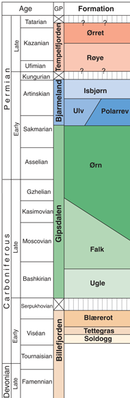
The most important Upper Palaeozoic tectonic provinces are described below: we should note that the region had a totally different setting in the Upper Palaeozoic, when it formed part of a vast continental shelf extending from the developing Uralides westwards through northern Greenland and the Arctic Canada Sverdrup Basin to Alaska (Worsley et al. 1986; Beauchamp >et al. 1989; Doré 1991; Stemmerik & Worsley, 1989, 1995). The northern limits of that late Palaeozoic shelf are still a matter of debate – some authors have presented reconstructions invoking the existence of land areas to the north – slivers of northern Alaska and northeastern Siberia (Harland>et al. 1984; Embry 1989, 1993) - to explain the provenance of siliciclastic sediments from that direction. This vast province was characterised by a series of intrashelf basins, some – e.g. the Nordkapp and especially the Sverdrup Basin - of huge dimensions. The Upper Palaeozoic in this entire region displays 4 major sequences (Fig. 4), the boundaries between which reflect significant changes in climate, sea-level and tectonic regime; not least climate was an important controlling factor on sedimentational regimes – the region apparently passed from the humid tropical zone in the early Carboniferous through the northern arid zone in the mid- Carboniferous to early Permian, before entering more temperate conditions in the mid- Permian (Steel & Worsley 1984; Worsley et al.1986; Stemmerik & Worsley 1989; Beauchamp 1993; Stemmerik 1997, 2000).
Hammerfest Basin
Finnmark Platform
Loppa High
Bjarmeland Platform
Nordkapp Basin
RingvassГёy-Loppa and BjГёrnГёyrenna fault complexes
The BjГёrnГёya Basin
The Barents Sea western margin
Stappen High/BjГёrnГёya
Hammerfest Basin
The Hammerfest Basin is bounded by the Finnmark Platform in the south and by the Loppa High and the Bjarmeland Platform in the north (Fig. 1). The basin is faultcontrolled, extending E-W and was probably established in the Late Carboniferous (Gabrielsen et al. 1990), although main subsidence occurred in the Triassic and the early Cretaceous. Basinal development largely culminated in the mid-Cretaceous, but highly condensed upper Cretaceous and thin lower Tertiary shales are also preserved, in the basin, in spite of extensive late Tertiary uplift. There is no evidence of extensive late Palaeozoic evaporite deposition or of diapirism in the basin, in contrast to the Tromsø Basin to the west and the Nordkapp Basin to the east. The basin’s internal structure is characterised by a central dome located along the basin axis and by a complex pattern of dominantly westerly and west-northwesterly trending faults; all of these features predominantly reflect late Jurassic tectonism. A total of 29 exploration wells have been drilled in the Hammerfest Basin but only 2 have penetrated the Upper Palaeozoic succession (7120/9-2 in the basin itself had TD about 117 m below the top Permian, while 7120/12-2 on the southern margins penetrated a 1000 m thick upper Permian sequence resting on lower Permian dolomites and then red beds and basement).
Finnmark Platform
The Finnmark Platform is bounded by the Norwegian mainland to the south, by the southernmost extension of the RingvassГёy-Loppa Fault Complex to the west, and by the Hammerfest and Nordkapp basins to the north (Fig. 1). The eastern part of the Finnmark Platform in the Norwegian sector is characterised by an underlying rift topography with fault blocks containing siliciclastic sediments of Early Carboniferous age; these were onlapped in the mid-Carboniferous and the overlying sequence is carbonate-dominated, with minor evaporites in certain intervals (Figs. 5a & b). This development continues eastwards, paralleling the Kola Peninsula and on to the Timan-Pechora Basin, which shows a generally similar development (Johansen et al. 1993). During the course of the Permian the entire more stable western platform area (west of approx. 25В°) was transgressed, resultant sequences being characterised by siliciclastic and carbonate deposits. Late Jurassic movements along pre-existing faults later modified the platform, and late Tertiary differential uplift resulted in the present, gentle northward tilt of the platform. Five exploration wells have been drilled on the Finnmark Platform, all reaching the Upper Palaeozoic (7120/12-4 on the western platform and 7229/11-1, 7128/4-1, 7128/6-1 and 7228/9-1 in the east). In addition, 8 shallow cores have penetrated various parts of the Upper Palaeozoic succession, providing important stratigraphic and sedimentological information (Bugge et al. 1995; Stemmerik et al. 1995).
The Loppa High is a marked structural feature, sharply separated by the E-W trending Asterias Fault Complex from the Hammerfest Basin to the south and by theRingvassøy – Loppa and the Bjørnøyrenna fault complexes from the Tromsø andBjørnøya basins to the west (Gabrielsen et al. 1990) (Fig. 1). Eastwards it grades gentlydownwards into the Bjarmeland Platform. The area has undergone a complex geological history characterised by several phases of uplift/subsidence and subsequent tilting anderosion. The Loppa High exhibits a Mid-Carboniferous rift topography that was filled and draped successively by Upper Palaeozoic siliciclastic deposits, evaporites and carbonates(Figs 5c & d). Tectonic tilting during the Late Permian and Early Triassic was followed by gradual onlap during the early and mid-Triassic before rapid subsidence and the deposition of an unusually thick Upper Triassic succession, which now subcrops theQuaternary. Three exploration wells have been drilled on the Loppa High, all penetratingthe Upper Palaeozoic succession (7120/1-1, 7120/2-1 and 7121/1-1).
Bjarmeland Platform
The Bjarmeland Platform includes the extensive platform areas east of the Loppa High and north of the Nordkapp Basin (Fig. , Fig. 5b). Towards the south and west, the platform is divided into minor highs and sub-basins, thick evaporites and diapirism characterising one of these (the Svalis Dome, site of extensive shallow coring by IKU). The platform was established in the Permian, but subsequent uplift and erosion tilted the Palaeozoic and Mesozoic sequences towards the south so that unconsolidated Quaternary sediments overlie successively older rocks towards the north. Five exploration wells have been drilled on the Bjarmeland Platform, two of them in the transitional area between the platform and the Nordkapp and Hammerfest basins - both of these wells reached the Upper Palaeozoic (7226/11-1 and 7124/3-1), the former demonstrating mid-Carboniferous onlap of basement.
Nordkapp Basin
The Nordkapp Basin is a fault-controlled basin located along the northeast-southwest trending Palaeozoic rift that extends eastwards from the Hammerfest Basin (Gabrielsen et al. 1990). The basin is bounded by the Bjarmeland Platform to the north and the Finnmark Platform to the south (Fig. 1) and is divided into a southwestern and a northeastern segment. During the late Palaeozoic this was a site of extensive halite deposition and the basin is characterised by pronounced salt diapirism. The movement of Palaeozoic salt began in the Early Triassic, and the diapirs have undergone several phases of development. The basin is apparently dominated by a thick, Mesozoic, mainly Triassic, succession, but poor seismic resolution makes determination of Palaeozoic thicknesses uncertain – although in contrast to the Hammerfest Basin, they were surely significant. One exploration well (7228/9-1S) drilled on the margin of the Nordkapp Basin penetrated the Upper Palaeozoic succession; it bottomed in mobilised halite of the Gipsdalen Group. A second well (7228/7-1) drilled recently in the basin itself penetrated Triassic sandstones abutting a late Palaeozoic diapir; this well also encountered an apparently allochthonous block of Permian carbonates, apparently moved out of place as a result of the diapirism.
RingvassГёy-Loppa and BjГёrnГёyrenna fault complexes
The boundary between the older platform areas and highs in the east and the deep, younger basins along the western margin of the Barents Sea is defined by a series of fault complexes in the area south of 74Вє30' N. The heavily faulted and tilted zone along the western margins of the Finnmark Platform passes northwards into the NNE-trending RingvassГёy-Loppa Fault Complex, which separates the Hammerfest Basin from the deep TromsГё Basin and the Loppa High, before forming the southwestern margins of the Loppa High (Gabrielsen et al. 1990) (Fig. 1). Towards the north, this abuts the NNE trending BjГёrnГёyrenna Fault Complex, which defines the junction between the northern Loppa High and the BjГёrnГёya Basin. The main faults within this province are of Palaeozoic and older origin and were reactivated several times during the Mesozoic and Tertiary. Several exploration wells have been drilled in the area; one of them, 7119/7-1 in the downfaulted TromsГё Basin, was terminated in a diapir mobilising salt of probable late Palaeozoic age.
The BjГёrnГёya Basin
The BjГёrnГёya Basin trends NE-SW between the Loppa and Stappen highs. It is separated by the Leirdjupet Fault Complex into a deeper western and shallower eastern part (the Fingerdjupet Subbasin). Although predominantly a Mesozoic feature, with an extremely thick Cretaceous section, rifting may have started already in the late Palaeozoic to form a precursor to the major Mesozoic subsidence event. Three exploration wells have been drilled in the in the Fingerdjupet Subbasin, one of them, 7321/8-1 penetrated 86 m of Upper Permian rocks.
The Barents Sea western margin
The Barents Sea margin consists of deep basins of late Mesozoic and Tertiary age, including the Harstad Basin, the TromsГё Basin, the SГёrvestsnaget Basin and the Vestbakken volcanic province (Fig. 1). The Mesozoic Senja Ridge and the VeslemГёy High define the southeastern margins of the SГёrvestsnaget Basin. Seismic observations suggest the presence of salt or mud diapirs in the SГёrvestsnaget Basin, in the former case possibly suggesting a Late Palaeozoic age for the basin. None of the exploration wells drilled so far on the Barents Sea margin have reached the Upper Palaeozoic.
Stappen High/BjГёrnГёya
The Stappen High trends N-S from 73º30′ N to at least 75º30′ N at 18 to 19º E (Gabrielsen et al. 1990). Bjørnøya forms its highest point lying at the boundary between the Barents Sea marginal basins and the Palaeozoic and Mesozoic platform areas in the east. The Stappen High, like the Loppa High, underwent a complex late Palaeozoic development involving several phases of uplift, faulting and tilting, all of which have resulted in a condensed and highly variable Upper Palaeozoic and Triassic sedimentary succession (Worsley et al. 2001). Thermal indicators suggest rapid subsidence (Sættem et al. 1994) through the rest of the Mesozoic before the area again became a positive element at some stage in the Tertiary.