
Collection of educational charts
All charts can be downloaded by clicking on the images.
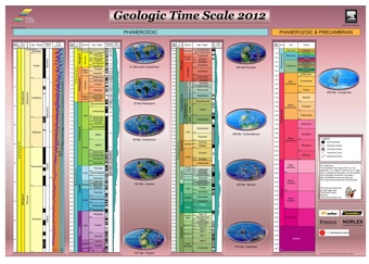
| Geologic Time Scale 2012 | |
Geologic Time Scale 2012 (Aug. 2012) Dimensions: 71 x 102 cm (28" x 40") This chart displays the International Divisions of Geologic Time, geomagnetics and sea-level changes and 10 paleogeographic maps. Poster can be downloaded.
|
 |
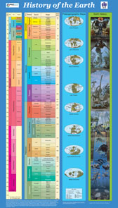
| History of the Earth | |
History of the Earth (Sept. 2007) Dimensions: 125 x 68 cm (50" x 28") This poster is geared toward classrooms and for high school and undergraduate students. It displays the International Divisions of Geologic Time, 9 paleogeographic maps and schematic evolution of life. Poster can be downloaded, or send $10 for postage for up to 2 posters (no international mail) to: Gabi Ogg: 1224 N. Salisbury St., West Lafayette, Indiana 47906
|
 |
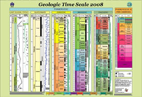
| Geologic Time Scale 2008 | |
Geologic Time Scale 2008 (Aug. 2008) Dimensions: 67 x 97 cm (27" x 39") This chart displays the International Divisions of Geologic Time, geomagnetics and sea-level changes. The Quaternary and the last glacial Cycle are shown in detail. The official rgb and cmyk color codes for the chronostratigraphic units are printed on the back of the poster. This poster can only be ordered from the Commission for the Geological Map of the World |
 |
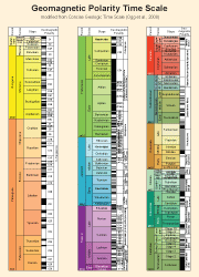
| Geomagnetic Polarity Time Scale | |
Geomagnetic Polarity Time Scale (Feb. 2010) Dimensions: 30 x 40 cm (12" x 16") This chart displays the Geomagnetic Polarity Time Scale modified from "The Concise Geologic Time Scale" (Ogg et al., 2008, Cambridge University Press)
|
 |
| Cenozoic Charts | |
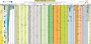
| Pliocene-Pleistocene Chart (Sept. 2008)
Dimensions: 110 x 230 cm (44" x 92") This chart displays the International Divisions of Geologic Time, selected regional stages, geomagnetics, oxygen-18, Deuterium and CO2 curves, sea-level sequences and several fossil zonations (planktonic foraminifera, calcareous nannofossils, dinoflagellate cysts, North Sea microfossil zonations, radiolarians, diatoms, mammals and Chinese Loess) |
 |
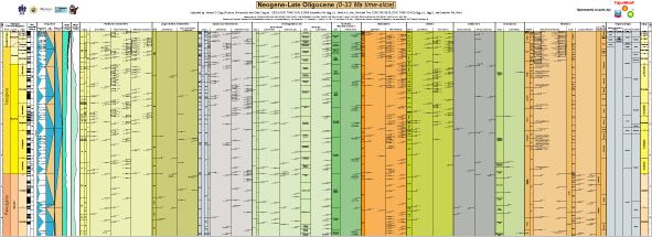
Neogene Chart (Sept. 2008) Dimensions: 95 x 262 cm ( 38' x 105") This chart displays the International Divisions of Geologic Time, selected regional stages, geomagnetics, oxygen-18 and carbon-13 curves, sea-level sequences and several fossil zonations (planktonic and benthic foraminifera, calcareous nannofossils, dinoflagellate cysts, North Sea microfossil zonations, radiolarians, diatoms, ostracods, charophytes and mammals) |
 |
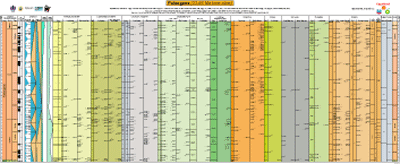
Paleogene Chart (Sept. 2008) Dimensions: 99 x 242 cm (40" x 97") This chart displays the International Divisions of Geologic Time, selected regional stages, geomagnetics, oxygen-18 and carbon-13 curves, sea-level sequences and several fossil zonations (planktonic and benthic foraminifera, calcareous nannofossils, dinoflagellate cysts, North Sea microfossil zonations, radiolarians, diatoms, ostracods, charophytes and mammals) |
 |
| Mesozoic Charts | |
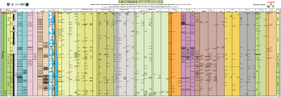
Late Cretaceous Chart (Sept. 2008) Dimensions: 107 x 307 cm (43" x 123") This chart displays the International Divisions of Geologic Time, geomagnetics, sea-level sequences and several fossil zonations (ammonites, planktonic and benthic foraminifera, calcareous nannofossils, dinoflagellate cysts, radiolarians, belemnites, inoceramids, rudists, ostracods, charophytes and mammals) |
 |
| Mid-Cretaceous Chart (Sept. 2008)
Dimensions: 109 x 275 cm (44" x 110") This chart displays the International Divisions of Geologic Time, geomagnetics, sea-level sequences and several fossil zonations (ammonites, planktonic and benthic foraminifera, calcareous nannofossils, dinoflagellate cysts, radiolarians, belemnites, rudists, ostracods, charophytes and calcareous algae) |
 |
| Jurassic-Cretaceous Chart (Sept. 2008)
Dimensions: 93 x 334 cm (38" x 134") This chart displays the International Divisions of Geologic Time, geomagnetics, sea-level sequences and several fossil zonations (ammonites, planktonic and benthic foraminifera, calcareous nannofossils, calpionellids, dinoflagellate cysts, radiolarians, belemnites, brachiopods, rudists, ostracods, charophytes and calcareous algae) |
 |
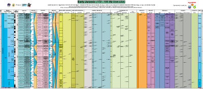
| Lower Jurassic Chart (Sept. 2008)
Dimensions: 91 x 206 cm (37" x 83") This chart displays the International Divisions of Geologic Time, geomagnetics, sea-level sequences and several fossil zonations (ammonites, benthic foraminifera, calcareous nannofossils, dinoflagellate cysts, radiolarians, belemnites, brachiopods, ostracods, charophytes) |
 |
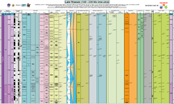
| Upper Triassic Chart (Sept. 2008)
Dimensions: 108 x 182 cm (44" x 73") This chart displays the International Divisions of Geologic Time, geomagnetics, sea-level sequences and several fossil zonations (ammonites, benthic foraminifera, calcareous nannofossils, dinoflagellate cysts, radiolarians, pelecypods, ostracods, spores and pollen) |
 |
| Lower Triassic Chart (Sept. 2008)
Dimensions: 108 x 154 cm (44" x 62") This chart displays the International Divisions of Geologic Time, geomagnetics, sea-level sequences and several fossil zonations (ammonites, benthic foraminifera, dinoflagellate cysts, radiolarians, ostracods, charophytes,spores and pollen, vertebrates) |
 |
| Paleozoic Charts | |
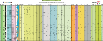
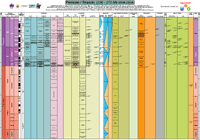
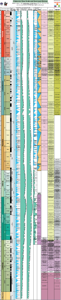
Paleozoic Chart (Sept. 2008) Dimensions: 315 x 63 cm (126" x 26") This long chart displays the International Divisions of Geologic Time, geomagnetics, comparison of sea-level sequences and trends, and major fossil zonations ( ammonoids, conodonts, fusulinids and other benthic foraminifera,trilobites, graptolites, small shelly fossils, archaeocythans) Paleozoic Chart References and Sources
|
 |
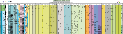
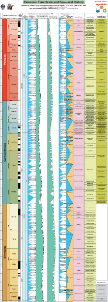
Upper Paleozoic Chart (Sept. 2008) Dimensions: 177 x 63 cm (71" x 26") This chart displays the International Divisions of Geologic Time, geomagnetics, comparison of sea-level sequences and trends, and major fossil zonations ( ammonoids, conodonts, fusulinids and other benthic foraminifera) |
 |
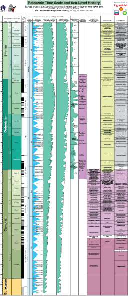
Lower Paleozoic Chart (Sept. 2008) Dimensions: 146 x 63 cm (59" x 26") This chart displays the International Divisions of Geologic Time, geomagnetics, comparison of sea-level sequences and trends, and major fossil zonations (conodonts, trilobites, graptolites, small shelly fossils, archaeocythans) |
 |
| Back to top | |