
Chapter 9. Chronostratigraphic Units
A. Nature of Chronostratigraphic Units
Chronostratigraphic units are bodies of rocks, layered or unlayered, that were formed during a specified interval of geologic time.
The units of geologic time during which chronostratigraphic units were formed are called geochronologic units.
The relation of chronostratigraphic units to other kinds of stratigraphic units is discussed in Chapter 10.
B. Definitions
1. Chronostratigraphy. The element of stratigraphy that deals with the relative time relations and ages of rock bodies.
2. Chronostratigraphic classification. The organization of rocks into units on the basis of their age or time of origin.
The purpose of chronostratigraphic classification is to organize systematically the rocks forming the Earth's crust into named units (chronostratigraphic units) corresponding to intervals of geologic time (geochronologic units) to serve as a basis for time-correlation and a reference system for recording events of geologic history.
3. Chronostratigraphic unit. A body of rocks that includes all rocks formed during a specific interval of geologic time, and only those rocks formed during that time span. Chronostratigraphic units are bounded by synchronous horizons.
The rank and relative magnitude of the units in the chronostratigraphic hierarchy are a function of the length of the time interval that their rocks subtend, rather than of their physical thickness.
4. Chronostratigraphic horizon (Chronohorizon). A stratigraphic surface or interface that is synchronous, everywhere of the same age.
C. Kinds of Chronostratigraphic Units
1. Hierarchy of formal chronostratigraphic and geochronologic unit terms. The Guide recommends the following formal chronostratigraphic terms and geochronologic equivalents to express units of different rank or time scope (Table 3).
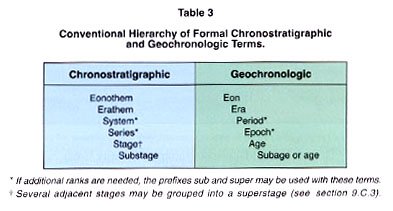
Position within a chronostratigraphic unit is expressed by adjectives indicative of position such as:basal, lower, middle, upper, etc.; position within a geochronologic unit is expressed by temporal adjectives such as:early, middle, late, etc.
2.Stage (and Age). The stage has been called the basic working unit of chronostratigraphy because it is suited in scope and rank to the practical needs and purposes of intraregional chronostratigraphic classification.
a. Definition. The stage includes all rocks formed during an age. A stage is normally the lowest ranking unit in the chronostratigraphic hierarchy that can be recognized on a global scale.
It is a subdivision of a series.
b. Boundaries and stratotypes. A stage is defined by its boundary stratotypes, sections that contain a designated point in a stratigraphic sequence of essentially continuous deposition, preferably marine, chosen for its correlation potential.
The selection of the boundaries of the stages of the Standard Global Chronostratigraphic Scale deserves particular emphasis because such boundaries serve to define not only the stages but also chronostratigraphic units of higher rank, such as series and systems.
c. Time span. The lower and upper boundary stratotypes of a stage represent specific moments in geologic time, and the time interval between them is the time span of the stage. Currently recognized stages vary in time span, but most range between 2 and 10 million years.The thickness of the strata in a stage and its duration in time are independent variables of widely varying magnitudes.
d. Name. The name of a stage should be derived from a geographic feature in the vicinity of its stratotype or type area.
In English, the adjectival form of the geographic term is used with an ending in "ian" or "an". The age takes the same name as the corresponding stage.
3. Substage and Superstage
A substage is a subdivision of a stage whose equivalent geochronologic term is subage.
Adjacent stages may be grouped into a superstage. Names of substages and superstages follow the same rules as those of stages.
4. Series (and Epoch)
a. Definition. The series is a chronostratigraphic unit ranking above a stage and below a system. The geochronologic equivalent of a series is an epoch.
The terms superseries and subseries have been used only infrequently.
b. Boundaries and boundary-stratotypes. Series are defined by boundary stratotypes (see section 9.H).
c. Time span. See section 9.D.
The time span of currently accepted series ranges from 13 to 35 million years.
d. Name. A new series name should be derived from a geographic feature in the vicinity of its stratotype or type area. The names of most currently recognized series, however, are derived from their position within a system:lower, middle, upper.
Names of geographic origin should preferably be given the ending "ian" or "an".
The epoch corresponding to a series takes the same name as the series except that the terms "lower" and "upper" applied to a series are changed to "early" and "late" when referring to an epoch.
e. Misuse of"series". The use of the term "series" for a lithostratigraphic unit more or less equivalent to a group should be discontinued.
5. System (and Period)
a. Definition. A system is a unit of major rank in the conventional chronostratigraphic hierarchy, above a series and below an erathem. The geochronologic equivalent of a system is a period.Occasionally, the terms subsystem and supersystem have been used.
b. Boundaries and boundary-stratotypes. The boundaries of a system are defined by boundary-stratotypes (see section 9.H).
c. Time span. The time span of the currently accepted Phanerozoic systems ranges from 30 to 80 million years, except for the Quaternary System that has a time span of only about 1.64 million years.
d. Name. The names of currently recognized systems are of diverse origin inherited from early classifications: some indicate chronologic position (Tertiary, Quaternary), others have lithologic connotation (Carboniferous, Cretaceous), others are tribal (Ordovician, Silurian), and still others are geographic (Devonian, Permian).
Likewise, they bear a variety of endings such as "an", "ic", and "ous". There is no need to standardize the derivation or orthography of the well-established system names. The period takes the same name as the system to which it corresponds.
6. Erathem (and Era). An erathem consists of a group of systems.
The geochronologic equivalent of an erathem is an era.The names of erathems were chosen to reflect major changes of the development of life on the Earth:
Paleozoic (old life), Mesozoic (intermediate life), and Cenozoic (recent life). Eras carry the same name as their corresponding erathems.
7. Eonothem (and Eon). An eonothem is a chronostratigraphic unit greater than an erathem. The geochronologic equivalent is an eon. Three eonothems are generally recognized, from older to younger, the Archean, Proterozoic and Phanerozoic eonothems. The combined first two are usually referred to as the Precambrian.
The eons take the same name as their corresponding eonothems.
8. Nonhierarchical formal chronostratigraphic units - the Chronozone.
a. Definition. A chronozone is a formal chronostratigraphic unit of unspecified rank, not part of the hierarchy of conventional chronostratigraphic units. It is the body of rocks formed anywhere during the time span of some designated stratigraphic unit or geologic feature. The corresponding geochronologic unit is the chron.
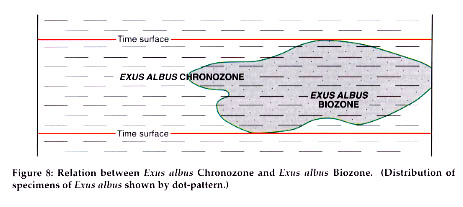
b. Time span. The time span of a chronozone is the time span of a previously designated stratigraphic unit or interval, such as a lithostratigraphic, biostratigraphic, or magnetostratigraphic polarity unit.It should be recognized, however, that while the stratigraphic unit on which the chronozone is based extends geographically only as far as its diagnostic properties can be recognized, the corresponding chronozone includes all rocks formed everywhere during the time span represented by the designated unit. For instance, a formal chronozone based on the time span of a biozone includes all strata equivalent in age to the total maximum time span of that biozone regardless of the presence or absence of fossils diagnostic of the biozone (Figure 8).
Chronozones may be of widely different time spans. The designation of the boundaries of a chronozone and of its time span can be done in several ways depending on the nature of the stratigraphic unit on which the chronozone is based.If the unit has a designated stratotype, the boundaries and time span of the chronozone can be made to correspond either to those of the unit at its stratotype or to the total time span of the unit, which may be longer than that at the stratotype.
In this second case, the boundaries and time span of the chronozone would vary with increasing information concerning the time span of the unit.If the unit on which the chronozone is based is of the type which cannot appropriately have a designated stratotype, such as a biostratigraphic unit, its time span cannot be defined either because the time span of the reference unit may change with increasing information (see section 7.A).
c. Geographic extent. The geographic extent of a chronozone is, in theory, worldwide, but its pplicability is limited to the area over which its time span can be identified, which is usually less.
d. Name. A chronozone takes its name from the stratigraphic unit on which it is based, e.g., Exus albus Chronozone, based on the Exus albus Range Zone.
D. The Standard Global Chronostratigraphic (Geochronologic) Scale
1. Concept. A major goal of chronostratigraphic classification is the establishment of a hierarchy of chronostratigraphic units of worldwide scope, which will serve as a standard scale of reference for the dating of all rocks everywhere and for relating all rocks everywhere to world geologic history (See section 9.B.2). All units of the standard chronostratigraphic hierarchy are theoretically worldwide in extent, as are their corresponding time spans.
2. Present status. Table 4 shows the Standard Global Chronostratigraphic (Geochronologic) Scale of common current usage.
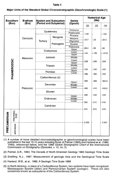
Numerical ages taken from recently published geologic time scales are added. Only the major units for which there is general agreement are shown.
E. Regional Chronostratigraphic Scales
The units of the Standard Global Chronostratigraphic (Geochronologic) Scale are valid only as they are based on sound, detailed local and regional stratigraphy.Accordingly, the route toward recognition of uniform global units is by means of local or regional stratigraphic scales.Moreover, regional units will probably always be needed whether or not they can be correlated with the standard global units.It is better to refer strata to local or regional units with accuracy and precision rather than to strain beyond the current limits of time correlation in assigning these strata to units of a global scale. Local or regional chronostratigraphic units are governed by the same rules as are established for the units of the Standard Global Chronostratigraphic Scale.
F. Subdivision of the Precambrian
The Precambrian has been subdivided into arbitrary geochronometric units, but it has not been subdivided into chronostratigraphic units recognizable on a global scale.
There are prospects that chronostratigraphic subdivision of much of the Precambrian may eventually be attained through isotopic dating and through other means of time correlation.However, the basic principles to be used in subdividing the Precambrian into major chronostratigraphic units should be the same as for Phanerozoic rocks, even though different emphasis may be placed on various means of time correlation, predominantly isotopic dating.
G. Quaternary Chronostratigraphic Units
The basic principles used in subdividing the Quaternary into chronostratigraphic units are the same as for other Phanerozoic chronostratigraphic units, although the methods of time correlation may have a different emphasis.As in the case of other chronostratigraphic units, those of the Quaternary require boundary definitions and designation of boundary stratotypes.
H. Procedures for Establishing Chronostratigraphic Units. See also section 3.B.
1. Boundary stratotypes as standards. The essential part of the definition of a chronostratigraphic unit is the time span during which the unit described was formed. Since the only record of geologic time and of the events of geologic history lies in the rocks themselves, the best standard for a chronostratigraphic unit is a body of rocks formed between two designated instants of geologic time.
For these reasons, the boundaries of a chronostratigraphic unit of any rank are defined by two designated reference points in the rock sequence.
The two points are located in the boundary-stratotypes of the chronostratigraphic unit which need not be part of a single section.Both, however, should be chosen in sequences of essentially continuous deposition since the reference points for the boundaries should represent points in time as specific as possible (see section 9.H.3).
2. Advantage of defining chronostratigraphic units by their lower boundary stratotypes. The definition of a chronostratigraphic unit places emphasis in the selection of the boundary-stratotype of its lower boundary; its upper boundary is defined as the lower boundary of the succeeding unit. This procedure avoids gaps and overlaps in the Standard Global Chronostratigraphic Scale.
For example, should it be shown that the selected horizon is at the level of an undetected break in the sequence, then the missing span of geologic history would belong to the lower unit by definition and ambiguity is avoided.
3. Requirements for the selection of boundary stratotypes of chronostratigraphic units. Chronostratigraphic units offer the best promise of being identified, accepted, and used globally and of being, therefore, the basis for international communication and understanding because they are defined on the basis of their time of formation, a universal property. Particularly important in this respect are the units of the Standard Global Chronostratigraphic (Geochronologic) Scale. The term "Global Boundary Stratotype Section and Point" (GSSP) has been proposed for the standard boundary-stratotypes of the units of this scale.
In addition to the general requirements for the selection and description of stratotypes (section 4.C), boundary-stratotypes of chronostratigraphic units should fulfill the following requirements:
* The boundary-stratotypes must be selected in sections representing essentially continuous deposition.The worst possible choice for a boundary-stratotype of a chronostratigraphic unit is at an unconformity.
* The boundary-stratotypes of Standard Global Chronostratigraphic Units should be in marine, fossiliferous sections without major vertical lithofacies or biofacies changes.Boundary stratotypes of chronostratigraphic units of local application may need to be in a nonmarine section.
* The fossil content should be abundant, distinctive, well preserved, and represent a fauna and/or flora as cosmopolitan and as diverse as possible.
* The section should be well exposed and in an area of minimal structural deformation or surficial disturbance, metamorphism and diagenetic alteration, and with ample thickness of strata below, above and laterally from the selected boundary-stratotype.
* Boundary stratotypes of the units of the Standard Global Chronostratigraphic Scale should be selected in easily accessible sections that offer reasonable assurance of free study, collection, and long-range preservation. Permanent field markers are desirable.
* The selected section should be well studied and collected and the results of the investigations published, and the fossils collected from the section securely stored and easily accessible for study in a permanent facility.
* The selection of the boundary stratotype, where possible, should take account of historical priority and usage and should approximate traditional boundaries.
* To insure its acceptance and use in the Earth sciences, a boundary stratotype should be selected to contain as many specific marker horizons or other attributes favorable for long-distance time correlation as possible.
The IUGS International Commission on Stratigraphy is the body responsible for coordinating the selection and approval of GSSPs of the units of the Standard Global Chronostratigraphic (Geochronologic) Scale.
I. Procedures for Extending Chronostratigraphic Units-Chronocorrelation (Time Correlation)
The boundaries of chronostratigraphic units are synchronous horizons by definition. In practice, the boundaries are synchronous only so far as the resolving power of existing methods of time correlation can prove them to be so.
All possible lines of evidence should be utilized to extend chronostratigraphic units and their boundaries. Some of the most commonly used are:
1. Physical Interrelations of strata. The Law of Superposition states that in an undisturbed sequence of sedimentary strata the uppermost strata are younger than those on which they rest.
The determination of the order of superposition provides unequivocal evidence for relative age relations.
All other methods of relative age determination are dependent on the observed physical sequence of strata as a check on their validity. For a sufficiently limited distance, the trace of a bedding plane is the best indicator of synchroneity.
2. Lithology. Lithologic properties are commonly influenced more strongly by local environment than by age, the boundaries of lithostratigraphic units eventually cut across synchronous surfaces, and similar lithologic features occur repeatedly in the stratigraphic sequence. Even so, a lithostratigraphic unit always has some chronostratigraphic connotation and is useful as an approximate guide to chronostratigraphic position, especially locally.
Distinctive and widespread lithologic units also may be diagnostic of chronostratigraphic position.
3. Paleontology. The orderly and progressive course of organic evolution is irreversible with respect to geologic time and the remains of life are widespread and distinctive.
For these reasons, fossil taxa, and particularly their evolutionary sequences, constitute one of the best and most widely used means of tracing and correlating beds and determining their relative age.
Biostratigraphic correlation, however, is not time correlation because homotaxy between samples may result from other causes than that the samples are equal in age.
4. Isotopic age determinations. Isotopic dating methods (U-Pb, Rb-Sr, K-Ar, Ar-Ar) based on the radioactive decay of certain parent nuclides at a rate that is constant and suitable for measuring geologic time provide chronostratigraphic data of high precision with analytical errors in the range of 0.1 to 2 percent. However, not all rock types and minerals are amenable to isotopic age determination.
Isotopic dating contributes age values expressed in years and it provides the major hope for working out the ages and age relationships of Precambrian rocks.
In some circumstances, isotopic age determinations provide the most accurate or even the only basis for age determination and chronostratigraphic classification of sedimentary, volcanic and other igneous rocks.
Discrepancies in age results may arise from the use of different decay constants.
It is important to geological comparisons, therefore, that the uniform sets of decay constants recommended by the IUGS Subcommission on Geochronology be used.
A method of age determination through radioactivity differing from those mentioned above is that based on the proportion of the radiocarbon isotope (14C) to normal carbon in the organic matter of sediments. This method has been extremely valuable but is limited in application to the dating of upper Quaternary strata.
5. Geomagnetic polarity reversals. Periodic reversals of the polarity of the Earth's magnetic field are utilized in chronostratigraphy, particularly in upper Mesozoic and Cenozoic rocks where a magnetic time scale has been developed. Polarity reversals are, however, binary and specific ones cannot be identified without assistance from some other method of dating such as biostratigraphy or isotopic dating.
6. Paleoclimatic change. Climatic changes leave imprints on the geological record in the form of glacial deposits, evaporites, red beds, coal deposits, faunal changes, etc.
Their effects on the rocks may be local or widespread and provide valuable information for chronocorrelation, but they must be used in combination with other specific methods.
7. Paleogeography and eustatic changes in sea level. As a result of either epeirogenic movements of the land masses or eustatic rises and lowerings of the sea level, certain periods of Earth history are characterized worldwide by a general high or low stand of the continents with respect to sea level. The evidence in the rocks of the resulting transgressions, regressions, and unconformities can furnish an excellent basis for establishing a worldwide chronostratigraphic framework. The identification of a particular event, however, is complicated by local vertical movements and so the method requires auxiliary help in order to identify the events correctly.
8. Unconformities. Even though a surface of unconformity varies in age and time-value from place to place and is never universal in extent, certain unconformities may serve as useful guides to the approximate placement of chronostratigraphic boundaries.
Unconformities, however, cannot fulfill the requirements for the selection of such boundaries (see section 9.H.3).
9. Orogenies. Crustal disturbances have a recognizable effect on the stratigraphic record.However, the considerable duration of many orogenies, their local rather than worldwide nature, and the difficulty of precise identification make them unsatisfactory indicators of worldwide chronostratigraphic correlation.
10. Other indicators. Many other lines of evidence may in some circumstances be helpful as guides to time-correlation and as indicators of chronostratigraphic position.
Some are more used than others, but none should be rejected.
J. Naming of Chronostratigraphic Units
A formal chronostratigraphic unit is given a binomial designation - a proper name plus a term-word - and the initial letters of both are capitalized.Its geochronologic equivalent uses the same proper name combined with the equivalent geochronologic term, e.g., Cretaceous System - Cretaceous Period.
The proper name of a chronostratigraphic or geochronologic unit may be used alone where there is no danger of confusion, e.g. "the Aquitanian" in place of "the Aquitanian Stage". See sections 3.B.3, and 3.B.4.
K. Revision of Chronostratigraphic Units. See sections 3.B and 9.H.