|
|
|
|
Vergara, L.1, H. Brunstad1, T. Nordlie1, M. A. Charnock2 & F.M. Gradstein3
1. RWE Dea Norge, Karenslyst allй 2-4, N-0212, Oslo
2. StatoilHydro, PO Box 7190, N-5020 Bergen
3. Geological Museum, POB 1172 Blindern, N-0318 Oslo
updated to follow: Stratigraphic Guide to the Cromer Knoll, Shetland and Chalk Groups of the North Sea and Norwegian Sea. Felix M. Gradstein & Colin C. Waters (editors), Mike Charnock, Dirk Munsterman, Michelle Hollerbach, Harald Brunstad, Øyvind Hammer, & Luis Vergara (contributors). Newsletter on Stratigraphy, vol 49/1 pp71-280, 2016
The Agat Formation is a complex lithostratigraphic unit that straddles the Cromer Knoll and Shetland Groups in the eastern part of the northernmost Viking Graben. Economic importance as a reservoir rock is demonstrated in the gas and condensate discovery in block 35/3.
It is a well-established unit, albeit not extensively documented in literature, and therefore is poorly understood. Discrepancies exist concerning age determinations, interpretations of the depositional environment, and well correlations in the literature. Following the document by Vergara et al. (this website), minor changes in the definition of the boundaries are introduced, and the main characteristics of the formation is better documented. Although good arguments might be made to retain the unit as a Member within the Rødby Formation, we have refrained from such for now. The unit is retained as a lithostratigraphic Formation pending more detailed study on provenances of different Agat ‘lobes’.Name: Agat Formation or Agatleddet
Derivatio nominis: Isaksen & Tonstad (1989) defined the unit after the sand bodies forming the reservoir for the Agat gas-condensate field in block 35/3.
In the original definition Isaksen & Tonstad (1989) gave a detailed account of the lithology of the Agat Formation.
"In the type well the Formation consists of white to light grey, fine- to medium-grained moderately to well-sorted sandstones alternating with grey claystones. The sandstones are usually micaceous and glauconitic and sometimes contain small amounts of pyrite. The sandstones in the type well are carbonate- and silica-cemented in zones. In the reference well, the upper part of the Formation consists of medium- and coarse-grained to pebbly sandstones and conglomerates alternating with dark grey claystones. The conglomerates are both matrix- and grain-supported. The claystones are often found as 0.5-5 m thick layers between the sandstones. They are dark grey, usually calcareous and contain varying amounts of siltstone. They may occasionally pass into light grey, micaceous, calcareous and glauconitic siltstones."In the type section of well 35/3-4 the formation measures nearly 200 m in thickness, and in the reference well 35/3-5 it spans over 380 m. In the 35/3 block gross thickness varies within this range. In the Gjøa area wells 35/9-3 and 36/7-3 encountered sand packages assigned to the Agat Formation, with 44 m and 100 m gross thickness, respectively.
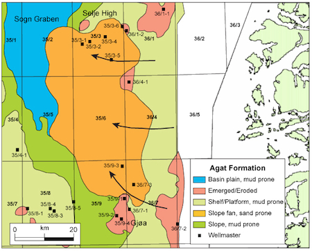
The geographical distribution and regional setting of the Agat Formation is seen in Figure 1 below. The unit is hitherto only known in blocks 35/3, 35/9, 36/7, 6204 and 6205. The figures demonstrate a rugged and largely exposed basin at the beginning of the Cretaceous. This relief was the result of regional Late Jurassic-Early Cretaceous rifting. The former relief was filled during the Early Cretaceous thermal subsidence phase, and a more gentle morphology between basin and slope was created, whereas the ancestral shelf back-stepped to the East and is mostly absent today.
 |
 |
| Fig. 1: Geographical distribution and schematic transect setting of the Agat Formation. The unit is hitherto only known in blocks 35/3, 35/9, 36/7, 6204 and 6205. The figures demonstrate a rugged and largely exposed basin at the beginning of the Cretaceous. This relief was the result of regional Late Jurassic-Early Cretaceous rifting. The former relief was filled during the Early Cretaceous thermal subsidence phase, and a more gentle morphology between basin and slope was created, whereas the ancestral shelf back-stepped to the East and is mostly absent today. | |
Slides available from type well 35/3-4 for the interval 660-4043 m (NPD)
Thin-sections
Not available.
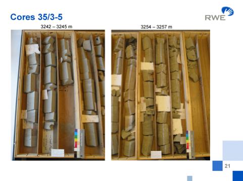
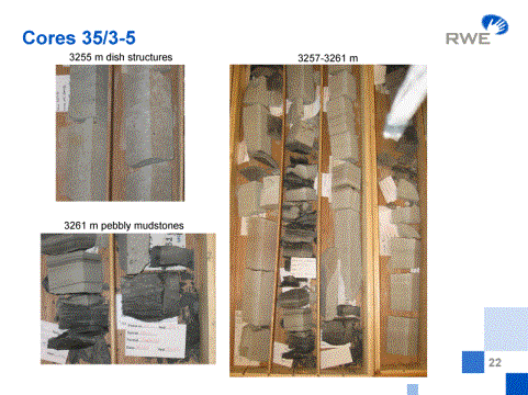
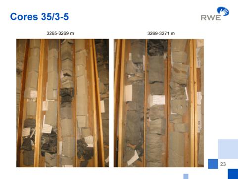
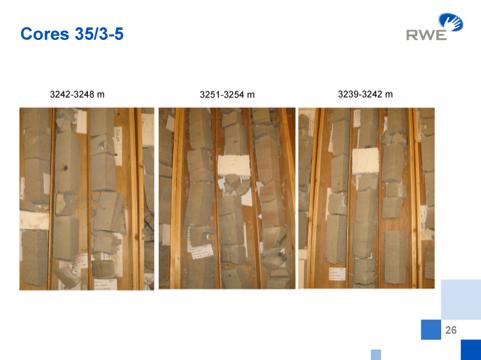
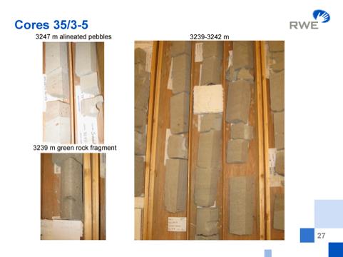
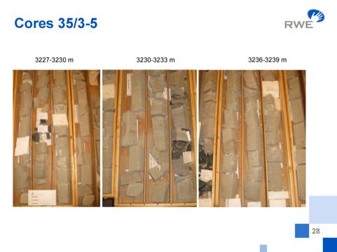
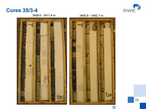
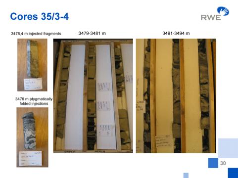
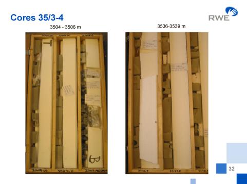
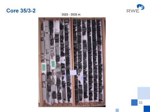
Core photographs
A suite of core photographs illustrates the main characteristics of the reservoir interval in wells 35/3-5,35/3-4 and 35/3-2.
 |
 |
 |
 |
 |
 |
 |
 |
 |
 |
 |
 |
 |
 |
WGS84 coordinates: 61°51'54.54" N 3°52'26.99" E
UTM coordinates: 6859631.80 N 545989.90 E
UTM zone: 31
Operator: Saga Petroleum
Completion date: 06.06.1981
Status: P&A G/C W
Interval of type section:
The type section is from 3542 m (originally 3589 m, see below) to 3345 m.
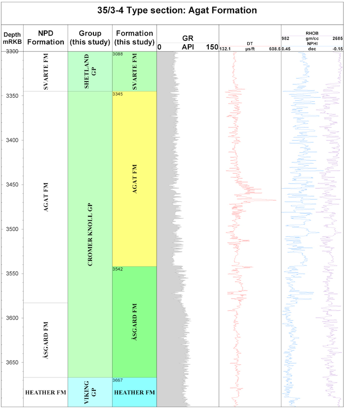
Fig. 2: Principal well logs of the Agat Formation in type well 35/3-4, north Viking Graben.(click to enlarge)
WGS84 coordinates: 61°47'46.71" N 3°54' 44.01" E
UTM coordinates: 6851990.69 N 548099.85 E
UTM zone: 31
Operator: Saga Petroleum
Completion date: 31.03.1982
Status: P&A dry
Interval of type section:
The reference section is from 3605 m (originally 3620 m, see below) to 3219 m.
 |
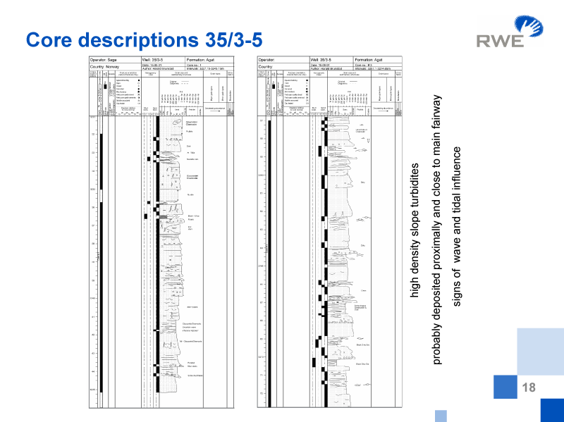 |
| Fig. 3a: Principal well logs of the Agat Formation in reference well 35/3-5, north Viking Graben. (click to enlarge) | Fig. 3b: Core descriptions of the reference section of the Agat Member. |
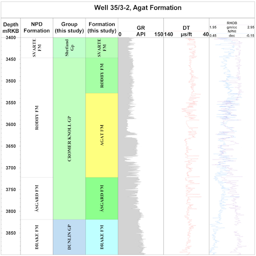
The boundaries are defined by Isaksen & Tonstad (1989) at the base and top of the sandstone interval as suggested by the gamma-ray and velocity logs, but the argument is made here to place the base at the base of massive sandstones, which occurs at 3542 m instead of 3589 m (Figure 2). As seen in this figure, both density and velocity logs exhibit changes that result in an acoustic impedance contrast. Likewise, in the reference section well 35/3-5 (Figure 3) the base is slightly shifted up from originally 3620 m to 3605 m. The upper limit in both well sections occurs at a high gamma-ray spike now viewed as representing a maximum flooding surface, and is maintained here. The boundaries picked for wells 35/3-1 and 35/3-2 (Figures 5 and 6) are in agreement with these criteria.
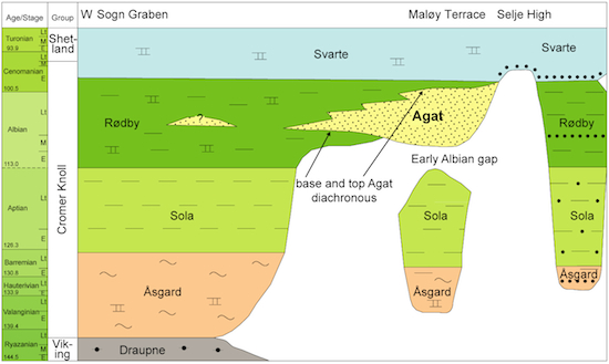
Both base and top of the Agat unit are diachronous, as reasonably expected from its ‘multiple source mass-flow facies’ (see below). Taking the base of the Shetland Group at the top of the Agat Formation in well 35/3-5 extends the Cromer Knoll Group very slightly in Upper Cretaceous, as reasonably locally expected from lithologic boundaries.Figs. 2 - 5 show the main logs for wells 35/3-4, 35/3-5, 35/3-2 and 35/3-1. The Agat Formation normally has a distinct expression that shows up well in the gamma ray log. In some cases the density log shows better contrasts, as in well 35/3-1 at the base of the unit. The array of logs illustrated here is suitable for recognizing the base of the sands that mark the boundaries of the unit.
|
Fig. 4: Principal well logs of the Agat Formation in well 35/3-1 north Viking Graben. |
Fig. 5: Principal well logs of the Agat Formation in well 35/3-2, north Viking Graben. |
Figures 6 - 10 below provide seismic characteristics. The type seismic section in Figure 6 (cross line 1505 of 3D survey GP3D93R02) shows the type seismic section that ties to type well 35/3-4. It illustrates well the top and base of the Agat Formation, the Base Cretaceous Unconformity (BCU), plus three additional intra Agat Formation markers. An in-line over the same well is presented in Norlex Figure 7.
For reference well 35/3-5 cross line 2129 (Norlex Figure 9) and in-line 555 (above Norlex Figure 9) are illustrated, and are called here reference seismic sections. In addition a random section tying both wells 35/3-4 and 35/3-5 (Norlex Figure 10) helps to illustrate the complexity of the seismic facies and deformation. Seismic sections over reference well 35/3-5 were published by Gulbrandsen (1987) and Shanmugan et al. (1994), while the Millennium Atlas (Copestake et al., 2003, fig. 12/20b) shows a line tying three key wells.
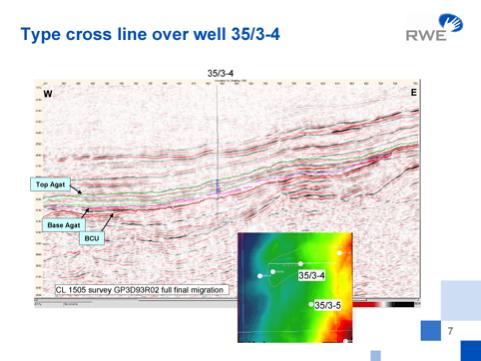
Figure 6. Type seismic section for the Agat Member: cross line |
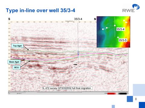
Figure 7. Type seismic section for the Agat Member: in-line |
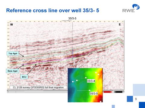
Figure 8. Seismic section through reference well: cross line |
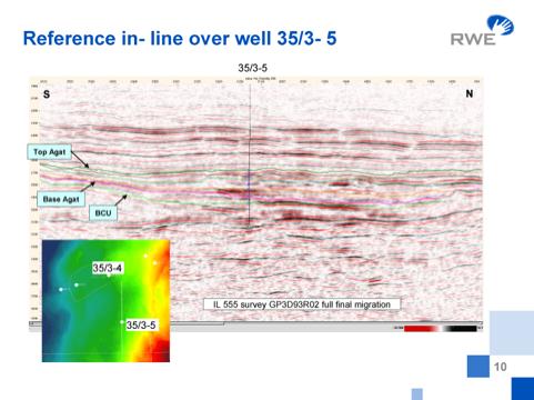
Figure 9 Seismic section through reference well: in-line |
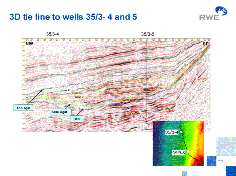
Figure 10. Seismic section through type and reference wells of the Agat Member
The first biostratigraphic reports are from Robertson Research (well 35/3-1), where they stated an Albian-Aptian age for the Agat sands. Based on the understanding of the zonal use of more than 20 foraminiferal and dinocyst events in the Agat region, fine-tune correlations in the reservoir sand interval were performed. The Cretaceous foraminiferal zonation compiled by Gradstein et al. (1999) is reproduced in Figure 11. The Agat reservoir sands mainly extend from Zone NCF6, mid Albian through Zone NCF10, late early Cenomanian.
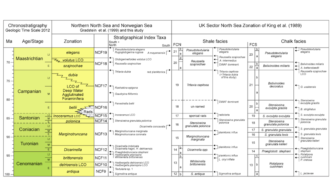 |
| Fig. 11b: Upper Cretaceous zonation for the Norwegian Sea, offshore mid-Norway, with stratigraphical index taxa for the region under study and taxa observed in its southern part only. The zonation is compared to the RASC model zonation using foraminifera and dinoflagellates. The zonation compares well with the North Sea zonation for shaly facies by King et al (1989), and is slightly more detailed in part. As expected, the chalk facies zonation of the North Sea does not compare or apply. |
| Click to enlarge |
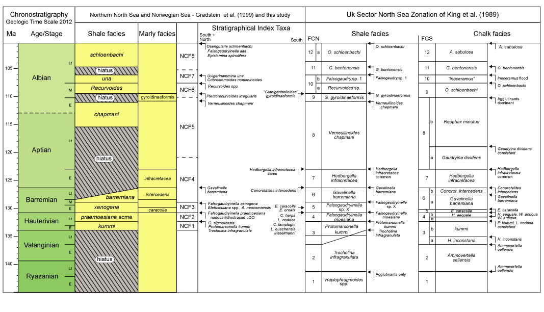 |
| Fig. 11a: Lower Cretaceous zonation, offshore mid- Norway with stratigraphical index taxa for shaly facies (more predominant northward), and for marly facies (more predominant southward). The zonation compares with the North Sea zonation for shaly (north) and for marly (south) facies of King et al. (1989), with which it shown taxa and zones in common. Seemingly, stratigraphic resolution decreases northward, but this is partly a bias from a more limited data set than available to King et al (op.cit.) in the North Sea. |
Gradstein & Agterberg (1998) first proposed that H. delrioensis FCO & LCO are useful to correlate the Agat sands and further north; these levels separate more scattered Rødby sands, assigned to lower Cenomanian, from more massive Rødby sands, assigned to middle Cenomanian, Turonian or Coniacian. The planktonic LCO event, observed in 14 wells, evidently is a lull in sand sedimentation. In the 35 block (Agat) area, the H. delrioensis FCO event occurs in the uppermost NCF8 Zone with the LO of Ovoidinium scabrosum (Upper Albian), whereas the H. delrioensis LCO event marks the top of the NCF10 zone, at the transition from lower to middle Cenomanian, which here also includes the LO’s of Rhombodella paucispina, Plectorecurvoides alternans and Lingulogavelinella jarzevae. In terms of local sands, the H. delrioensis FCO event in the Agat area appears abruptly almost at the top of the massive Agat sands of Albian age in well 35/3-4, and the LCO event occurs above some more Agat sands of possible Early Cenomanian age in 35/3-5. Hence, the stratigraphic range of common to abundant Hedbergella delrioensis is in the upper half of the Agat sands.
The age determinations are summarized in the wells chronogram of Figure 12 and well correlation Figure 13. Hydrocarbon bearing sands in the 35/3-2 and 35/3-4 wells are of mid - late Albian age, and more than 100 m thick (net) in 35/3-4. The upper massive sands in the 35/3-5 well, devoid of hydrocarbons, are of early Cenomanian age. In the most landward wells 36/1-1, 1-2 and 1-4, the Albian sediments are absent. Understanding of reworking in these wells is crucial to age determinations. Reworked Aptian assemblages occur in well 35/3-1 (3935 to 4085 m), while reworked Jurassic palynomorphs occur in a lower section (4120-4141 m), and also in Albian sands of well 35/3-5, together with Lower Cretaceous dinoflagellate cysts. Apart from this, the base of the Agat Formation is diachronous, responding to deposition first in the East followed by slightly younger sand dispersal to the West.
In well 35/9-3 in the Gjøa area (Figure 1 left), well 35/9-3 penetrated a reservoir section (2657.5 -2701.5 m) of Middle to Late Albian. A next well 36/7-3 encountered a massive sand reservoir section (2532-2632 m) dated Late Albian. Both intervals are assigned to the Agat Formation, and lateral to shales or marls of the Rødby Formation.
 Click to enlarge Fig. 12: Chronogram and principal correlations in time of the Agat Formation in key wells, north Viking Graben. |
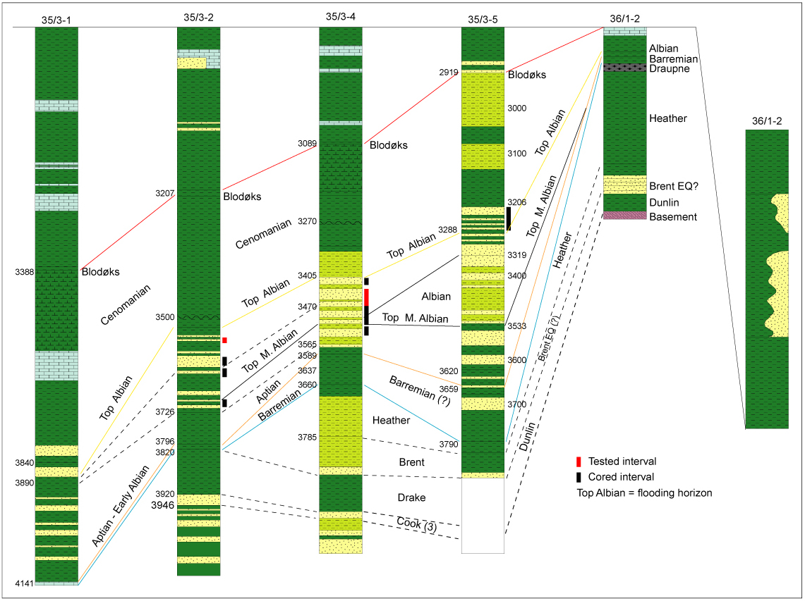 Click to enlarge Fig. 13: Detailed correlation of microfossil levels in the Agat Formation below Blødoks and above Jurassic (shown a bit). Top Albian is a flooding (condensation) horizon with microfossil acmes. |
The Agat Formation is of mid Albian through early Cenomanian age.
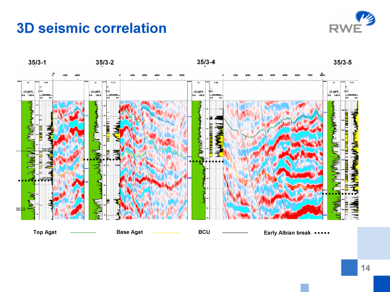
Figure 14. 3D seismic correlation of the Agat Member in block 35/3.
Depositional models have ascribed the lack of pressure communication between wells 35/3-2 and 35/3-4 to primary depositional features. Bugge et al. (2001) presented a model where slide scars from small-scale slumping and sliding created accommodation space for preservation of isolated sand bodies transported by turbiditic currents. The sands are interpreted as high-density turbidites, probably deposited proximally and close to the main sediment fairway.
In general, the Agat facies associations in the wells show predominantly turbidite deposition, interacting with debris flows. Figure 1 gives an idea of the local basin configuration in Early Cretaceous from basin margin to deeper marine basin. Diverse agglutinated benthic foraminiferal assemblages retrieved from intervening shales in the Albian of the Agat wells are indicative of bathyal conditions (Gradstein et al., 1999), in accordance with a basin slope setting. Seismic facies extracted from 3D surveys in conjunction with isopach anomalies have constrained our depositional model by more accurately outlining the fan distribution. The upscaled regional depositional model (Figure1 ) shows the generalized extension of the fans of the Agat Formation, on the slope of the Måløy terrace. This is roughly in agreement with the model of Copestake et al. (2003; Fig. 12/20). Its hypothetical extension into the Sogn Graben, as postulated by Shanmugan et al. (1984) and Skibeli et al. (1995), remains to be proven by drilling.
BUGGE, T., TVEITEN, B. & BÄCKSTRÖM, S. 2001. The depositional
history of the Cretaceous in the northeastern North Sea. In: Martinsen, O.
& Dreyer, T. (eds.) Sedimentary Environments Offshore Norway –
Paleozoic to Recent. Norwegian Petroleum Society Special Publication, 10, 279-291
COPESTAKE, P., SIMS, P., CRITTENDEN, S., HAMAR, G., INESON, J.,
ROSE, P. & TRINGHAM, M. (2003) Lower Cretaceous. In: Evans, D. et al. (eds.) The Millennium Atlas. The Geological Society
of London, 191-211.
GULBRANDSEN, A. 1987. Agat Field. In: Spencer, M.A. (ed.) Geology of the Norwegian oil and gas fields: Graham and Trotman, London, 363-370.
GRADSTEIN, F.M. & AGTERBERG, F.P. 1998 Uncertainty in
Stratigraphic Correlation. In: Gradstein, F., Sandvik, O. &
Milton, D. (eds.) Sequence Stratigraphy – Concepts and Applications.
Elsevier Publishing Company 9-29.
GRADSTEIN, F.M., KAMINSKI, M.A. & AGTERBERG, F.P. 1999.
Biostratigraphy and paleoceanography of the Cretaceous seaway between Norway
and Greenland. Earth Science Reviews 46, 27-98.
ISAKSEN, D. & TONSTAD, K. 1989. A revised Cretaceous and
Tertiary lithostratigrahic nomenclature for the Norwegian North Sea. Norwegian
Petroleum Directorate Bulletin, 5, 1-59.
NYSTUEN, J. P. 1999. Submarine sediment gravity flow deposits and
associated facies: core examples from the Agat Member. Extended Abstracts
Bergen Conference. Norwegian Petroleum Society, 211-215.
SHANMUGAN, G., LEHTONEN, L. R., STRAUME, T., SYVERSTSEN, S. E.,
HODGKINSON, R. J. & SKIBELI, M. 1994. Slump and Debris-Flow dominated Upper
Slope Facies in the Cretaceous of the Norwegian and Northern North Seas
(61-67єN): Implications for Sand Distribution. American Association of
Petroleum Geologists Bulletin, 78, 6, 910-937.
SHANMUGAN, G., BLOCH, R.B., MITCHELL, S.M., BEAMISH, G.W.J.,
HODGKINSON, R.J., DAMUTH, J.E., STRAUME, T., SYVERTSEN, S.E. & SHIELDS, K.E. 1995. Basin-floor fans in the North
Sea: sequence stratigraphic models vs. sedimentary facies. American
Association of Petroleum Geologists Bulletin 79, 4, 477-512.
SKIBELI, M., BARNES, K., STRAUME, T., SYVERSEN, S. E. &
SHANMUGAN, G. 1995. A sequence
stratigraphic study of Lower Cretaceous deposits in the northernmost North Sea.
In: Steel, R. et al. (eds.) Norwegian Petroleum
Society Special Publication, 5, 389-400.