 |
|
|
|
(Original definition in NPD Bulletin no. 5)
updated to follow: Stratigraphic Guide to the Cromer Knoll, Shetland and Chalk Groups of the North Sea and Norwegian Sea. Felix M. Gradstein & Colin C. Waters (editors), Mike Charnock, Dirk Munsterman, Michelle Hollerbach, Harald Brunstad, Øyvind Hammer & Luis Vergara (contributors). Newsletter on Stratigraphy, vol 49/1 pp71-280, 2016
The term Shetland Group was introduced by Deegan & Scull (1977) for a unit of mudstone with relatively minor interbedded argillaceous limestones lying between the Cromer Knoll and Montrose groups in the Northern North Sea. They did not define formations within the Shetland Group, but recognized six informal subdivisions and designated these 'Formations' A to F (Table 1).
The original definitions in the Norwegian Sector of the North Sea are in Dalland et al. (1988) and Isaksen &&Tonstad (1989). Here the original definition is updated. The Shetland Group has been extended in the Norwegian Sea such that it has a similar stratigraphic duration and boundaries to the original definition in the North Sea by Deegan & Scull (1977), (Table 1).
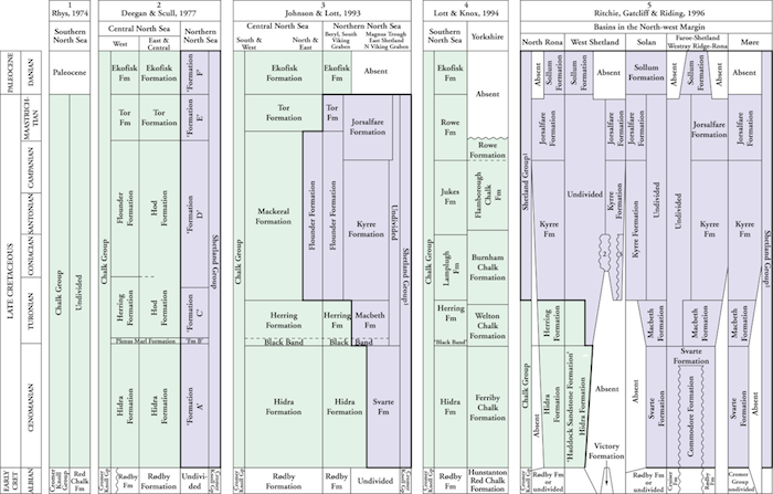
Table 1: Historical development of the Upper Cretaceous lithostratigraphical nomenclature of the offshore UK Sector (from Hopson 2005).
The nomenclature used here is derived from columns 3, 4, 5. (Click to enlarge)
In the UK Sector Northern North Sea Johnson & Lott (1993) followed Deegan & Scull (1977) in recognizing both the Chalk and Shetland groups, albeit with modified definitions (Table 4.2). The Shetland Group now includes all formations dominated by mudstone facies and the Chalk Group all formations dominated by chalky limestone facies. The differentiation of mudstone-dominated and limestone-dominated facies is achieved on the basis of gamma-values. Average values for the Chalk formations range up to about 30 API units, whereas those for the mudstone formations generally exceed 35 API units. In the South Viking Graben and northern parts of the Central North Sea, the Chalk and Shetland groups, as defined in this study, interdigitate.
Many of the Shetland Group mudstone formations named by Isaksen & Tonstad (1989) are adopted for the UK Sector in this report. However, mudstone equivalents of the Herring Formation (as redefined by Johnson & Lott, 1993) are included within a single formation, the Macbeth Formation, rather than the two formations recognized by Isaksen & Tonstad in the Norwegian Sector (the Blodøks and Tryggvason formations).
Named from the Shetland Islands off the north coast of Scotland (Deegan & Scull 1977). The group has now been expanded to include the formations of the former Chalk Group.
The group is typically developed as a siliclastic facies in the Northern North Sea and as a chalk facies in the Central North Sea. UK well 22/1-2A illustrates a section in the transition zone between the two facies (Johnson & Lott, 1993). A typical section of the chalk facies in the central area is represented by Norwegian well 1/3-1 (Figure 24 in Isaksen & Tonstad, 1989), while Norwegian well 25/1-1 (Figure 33 in Isaksen & Tonstad, 1989) provides a typical section of the siliciclastic facies in the northern area. UK well 22/1-2A illustrates a section in the transition zone between the two facies (Figures 5 and 25 in Isaksen & Tonstad, 1989).
In Norwegian well 1/3-1 the group is 1183 m thick, and in well 25/1-1 it measures 1284 m. Seismic interpretation and well data indicate that the thickness of the group ranges between 1000 and 2000 m in graben areas within the Norwegian Sector. The group shows considerable thinning towards and in the platform areas.
The Shetland Group in the UK Sector is up to 2000 m thick (see UK maps) in the Viking Graben, Beryl Embayment, East Shetland Basin and Magnus Trough (Johnson & Lott 1993).
A regional isopach of the Shetland Group thickness in the Norwegian Sea based on released well data is shown in the figure below. The isochore map is generated from Norlex data using thin plate splines (thickness constrained to original range). Thicknesses in metres. Circled well contain both top and base horizons. In the case of the Shetland Group this includes wells with a well TD within the group. The red wells have Norlex biostratigraphy. Note that this map is only a regional interpretation.
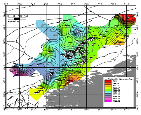
Depth to the top of the Shetland Group in the Norwegian Sea based on released well data. Click for PDF.

Regional isopach of the Shetland Group thickness in the Norwegian Sea based on released well data. The isochore map is generated from Norlex data using thin plate splines (thickness constrained to original range). Thicknesses in metres. Circled well contain both top and base horizons. In the case of the Shetland Group this includes wells with a well TD within the group. The red wells have Norlex biostratigraphy. Click for large version. |
The group consists of the chalk facies of chalky limestones, limestones, marls, and calcareous shales and mudstones. Chert (flint) occurs throughout the facies. The siliciclastic facies consists of mudstones and shales, partly interbedded with limestones (Johnson & Lott, 1993). In the Norwegian Sector sandstones are present in the lower part in the Agat Field area (block 35/3). The shales and sandstones are slightly calcareous to very calcareous. In the Maastrichtian age part of the unit the quantity of limestones is generally higher on the Horda Platform than in the Viking Graben.
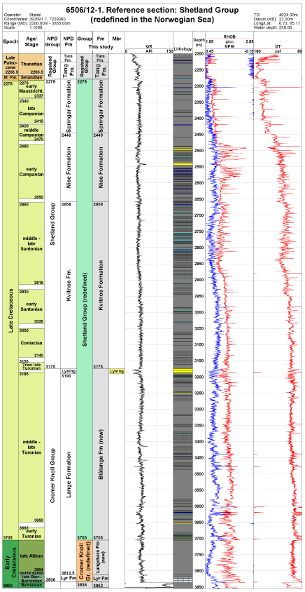
The well log and lithology section of our reference well 6506/12-1 shows, where the Shetland Group extends from the clear log break at 2279 m with lower Maastrichtian fossil taxa to the log break at 3705 m, just above the top of Albian index taxa in the Cromer Knoll Group.
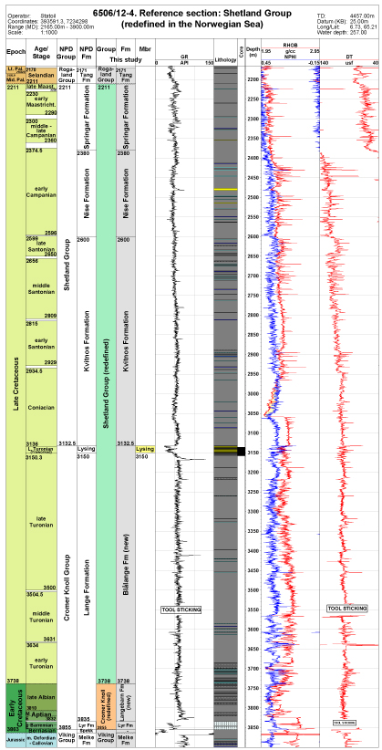
The well log and lithology section of our reference well 6506/12-4 shows, where the Shetland group extends from the clear log break at 2211 m with upper Maastrichtian fossil taxa to the log break at 3738 m, just above the top of Albian index taxa in the Cromer Knoll Group.
In the Norwegian Sector the group is overlain by Paleocene mudstones, marls or sandstones of the Rogaland Group.
In the Northern North Sea (UK Sector) the upper boundary is taken at the base of the argillaceous chalky limestones and interbedded calcareous mudstones of the Ekofisk Formation (Chalk Group) where it rests upon cleaner limestones of the Jorsalfare Formation.
In the Central North Sea the upper boundary is taken at the base of the hard chalky limestones of the Tor Formation (Chalk Group), where it rests upon the argillaceous mudstones with argillaceous chalky limestones of the Flounder Formation.
Typically, in the Norwegian Sector, the lower boundary is the contact with the calcareous mudstones or marlstones of the Cromer Knoll Group. On structural highs like the Horda Platform, Tampen Spur, Sørvestlandet and Mandal Highs the lower part of the group is occasionally absent, and the remainder rests unconformably on the Cromer Knoll Group, Jurassic or even older rocks.
In the Northern North Sea (UK Sector) the lower boundary is taken at the base of the essentially non-calcareous mudstones (Black Band) of the Macbeth Formation where it rests upon white to pale grey chalky limestones of the Hidra Formation (Chalk Group), or where the Chalk Group is absent, at the base of the calcareous mudstones or argillaceous chalky limestones of the Svarte Formation where it rests upon the less calcareous mudstones and chalky mudstones with interbedded limestones of the Rødby Formation (Cromer Knoll Group).
The Shetland Group ranges in age from Cenomanian to Danian. The siliciclastic facies is restricted in age to the Late Cretaceous. In the UK Sector the group is restricted in age to the Late Cretaceous, ranging from Turonian to Maastrichtian (see Table).
In well 6506/12-1, the upper part of the Shetland Group just below 2279 m contains G.michelinianus, O.costata, O.operculata, L.cooksonia and S.delitiense, belonging in Zone NCF18 of an Early Maastrichtian age. Just below the base of the group in this well near 3710 m, in the uppermost Cromer Knoll Group, occur A.grande, common H.planispira and O.schloenbachi of our Zone NCF8, Late Albian (see Figure 2.7a).
In well 6506/12-4, the upper part of the Shetland Group at 2220 m contains T.utinensis of Late Maastrichtian age, and just below the base at 3738 m common H.planispira and A.grande of Zone NCF8, Late Albian.
The Upper Cretaceous sequence in the North Sea was deposited in an open marine environment during a general rise in sea level (Hancock & Kauffman, 1979). On the basis of microfossil assemblages, King et al. (1989) suggested that the Shetland Group was deposited as a deeper water (bathyal) facies compared to the Chalk Group. Hancock (1990) noted a northward increase in the proportion of silt in the Shetland Group and postulated a northern provenance for the mudstones, with Greenland as a possible source area. The chalk facies formations were deposited as coccolith debris and other carbonate grains and sequences often show a cyclic pelagic sedimentation pattern termed periodite (d'Heur, 1986). In the Central Graben, extensive subsidence resulted in the chalk facies being dominated by allochthonous, redeposited chalks which were transported downslope as major slides, slumps, debris flows, and proximal and distal turbidites. The siliciclastic facies in the northern North Sea is less well studied. The influx of siliciclastic mud was higher, and carbonate production lower than in the area with chalk facies.
The Shetland Group in the Norwegian Sea is subdivided from older to younger in the Blålange Formation (new) and Kvitnos, Nise and Springar Formations (see Table).
In the northern North Sea the Shetland Group is represented by six siliciclastic facies units: the Svarte, Blodøks, Tryggvason, Kyrre, Jorsalfare and Hardråde Formations (see Table; all erected by Isaksen & Tonstad, 1989). In the southern North Sea the Shetland Group is now replaced by the Chalk Group and represented by the typically siliciclastic Blodøks Formation and six chalk facies units: the Hidra, Narve (new), Thud (new) and Magne (new), Tor and Ekofisk Formations (see Table). The Narve, Thud and Magne units were informally described by Fritsen & Riis (2000), subdividing the original Hod unit of Deegan & Scull (1977). The latter authors described the Blodøks, Hidra, Tor and Ekofisk units.
The Shetland Group in the Northern North Sea (UK Sector) is represented by three siliciclastic facies formations, in ascending order: the Macbeth, Kyrre and Jorsalfare formations (Johnson & Lott, 1993; see Table). In northern parts of the Central Graben, the Shetland Group is represented by a single formation, the Flounder Formation, which occurs between the chalky limestones of the Tor and Herring formations (Chalk Group). The lateral boundary with the Herring Formation (to the west, south and east) is transitional. The boundary with the Kyrre Formation and the lower part of the Jorsalfare Formation (to the north) is similarly transitional, but the limit of the Flounder Formation is more or less defined by the limit of the chalky limestones of the Tor Formation. The Herring and Flounder Formations in the UK Sector (Deegan & Scull, 1977) are regarded as equivalents of the Macbeth Formation and of the Kyrre Formation, respectively (Table 1).
When traced northwards of the Central Graben, the formations of the Shetland Group become increasingly difficult to differentiate in the UK Sector, only the Svarte Formation being consistently recognizable. The characteristic limestones of the Macbeth Formation do not extend into the East Shetland Basin, so that the boundary with the overlying Kyrre can no longer be recognized with certainty. Similarly, the Jorsalfare Formation, cannot be traced through the Northern North Sea area. Where the formations cannot be recognized, the mudstones are classed as undivided Shetland Group.