 |
|
|
|
updated to follow: Stratigraphic Guide to the Cromer Knoll, Shetland and Chalk Groups of the North Sea and Norwegian Sea. Felix M. Gradstein & Colin C. Waters (editors), Mike Charnock, Dirk Munsterman, Michelle Hollerbach, Harald Brunstad, Øyvind Hammer & Luis Vergara (contributors). Newsletter on Stratigraphy, vol 49/1 pp71-280, 2016
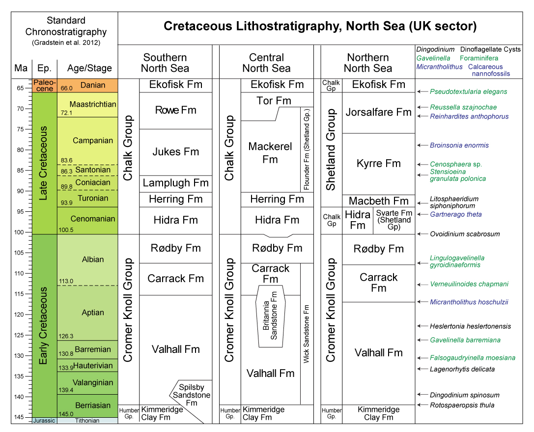
The term Chalk Group was introduced by Rhys (1974) in the UK Southern North Sea (Table 2) for a unit of Upper Cretaceous chalky limestones of Cenomanian to Maastrichtian age, lying between the Cromer Knoll Group below and a then undivided succession of Tertiary sediments above (now known as the Montrose Group). Subsequent drilling has shown that these chalky limestone lithologies in some areas do extend into the Danian (Ekofisk Formation). Deegan and Scull (1977) extended the definition of the group to include the Central and Northern North Sea (east of the Shetland Islands and southwards).
The term Chalk Group has subsequently been formally defined as an onshore lithostratigraphical unit by Hopson (2005). The definition provided by Hopson (2005) makes mention of the offshore successions, but are not an intrinsic part of that definition. The following account reflects a distinct description of the offshore successions, as defined by Johnson & Lott (1993) and Lott & Knox (1994).
In the thicker Chalk succession present in the Southern North Sea, the same units can be recognised as on land though a different nomenclature is used; the Hidra, Herring, Lamplugh and Jukes Formations correspond approximately with the Ferriby Chalk, Welton Chalk, Burnham Chalk and Flamborough Chalk Formations onshore (Lott & Knox, 1994; see Table 1), and the Rowe Formation is fully developed (note that the Chalk Group as defined in Lott & Knox, 1994, also includes the Ekofisk Formation of basal Paleogene age throughout the North Sea).
 |
 |
Table 2: Chalk Group subdivisions
From the characteristic chalky limestone lithology (Rhys, 1974, fig.7. p.9)
The group varies greatly in thickness, locally reaching over 1200m in rim synclines adjacent to major salt diapir developments east of the Sole Pit Inversion (UK_Maps).
It thins northwards over the Mid North Sea High (UK_Maps), before thickening into the Erskine Basin of the Central Graben, where it is up to 1500m thick (Johnson & Lott, 1993, Gatliff et al., 1994). It also thins southwards across the London-Brabant High into the eastern English Channel (Cameron et al., 1992). It reaches over 1000m thick in the Outer Moray Firth (Andrews et al., 1990; Johnson & Lott, 1993). Thinning, condensation and onlap relationships over some diapiric structures and tectonic highs are apparent from some wells (e.g. Block 23/26a, Foster & Rattey, 1993) and thins to a few metres or is entirely absent over the Fladen Ground Spur and Halibut Horst in the Outer Moray Firth (Andrews et al., 1990).
The Chalk Group is dominated by chalky coccolithic limestone, with or without flint and discrete marl, sponge, calcarenite, phosphatic, hardground and fossil-rich beds (Hopson, 2005). The division into limestone- and mudstone-dominated facies in the Central North Sea is evident in gamma-ray logs, with the chalky limestone formations on average up to 30 API units, whereas the mudstones are typically significantly greater than 35 API units (Johnson & Lott, 1993). Irregularities in the sonic logs are probably the result of alternations of soft and hard chalk and also the presence of chert (flint). The Central Graben primary pelagic chalks are interdigitated with large volumes of allochthonous chalk transported from the flanks of the graben by submarine slides, slumps, debris flows and turbidites during the Maastrichtian and Danian (Kennedy, 1987). The primary chalks are bioturbated and typically have low porosity (Kennedy, 1987), whereas the allochthonous deposits have higher porosity (Taylor & LaprГ©, 1987). Glauconitic sandstone is present in the Inner Moray Firth Basin, typical of the onshore Greensand facies (Andrews et al., 1990). Although sedimentation of the Chalk Group appears to be almost continuous in the North Sea during the Upper Cretaceous, stratigraphic breaks are recorded in the Moray Firth in late Albian/early Cenomanian, late Cenomanian/early Turonian, late Turonian, intra-Santonian, late Campanian and late Maastrichtian (Andrews et al., 1990).
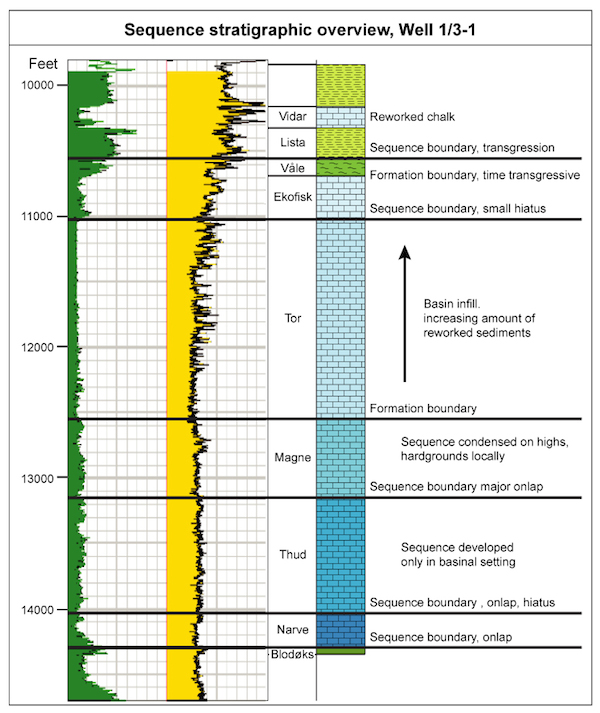
The figure below provides a very schematic sequence stratigraphic overview of Chalk units (in blue) in Norwegian well 1/3-1 (Hidra Fm not shown is near base of figure below BlodГёks Fm). (redrafted after Joint Chalk Research document, 2000, unpublished).
Conformable beneath Danian age Maureen Formation in parts of the North Sea. The group is evident at depth in seismic sections as an often featureless package with a top marked by strong continuous reflections traceable over much of the North Sea (Andrews et al. 1990).
The base of the Chalk Group occurs at a downward change from interbedded pale to dark grey and pink chalky, argillaceous limestones (Hidra Formation) to red-brown chalky mudstones of the RГёdby Formation (Cromer Knoll Group). The boundary is marked on the wireline log responses by an increase in gamma ray values and decrease in velocity (Lott & Knox, 1994).
The Chalk Group is widely distributed over the Central North Sea and extends into the South Viking Graben and East Shetland Platform (Johnson & Lott, 1993; UK_Maps). Erosion following Cenozoic uplift completely removed the Chalk Group from onshore Scotland and a zone from 20 to 100 km east of the coastline (Gatliff et al., 1994). Eastward from its outcrop, drilling has proved the Chalk Group to be buried at progressively deeper levels beneath up to 3500 m of Cenozoic and Quaternary deposits in the eastern part of the UK Sector (Gatliff et al., 1994). The group also extends across much of the Southern North Sea area, subcropping thin Pleistocene sediments west of the Sole Pit Inversion but lying beneath a thick Tertiary and Pleistocene cover in the Cleaver Bank basinal area east of the structure.
Over the stable East Midland Shelf the youngest chalk units are of Campanian or early Maastrictian age, with Maastrichtian (early only) chalk demonstrated in the south east of the area, adjacent to the North Norfolk coast (e.g. Peak & Hancock, 1970). The Chalk Group is absent through erosion over much of the Sole Pit Inversion structure but thickens eastwards into the Cleaver Bank Basin (UK_Maps), where Maastrichtian chalks are widely present and some Danian chalky limestone units also occur sporadically. Further eastwards the Chalk Group continues to increase in thickness into the Dutch Sector (Hancock, 1986).Cenomanian to Danian.
The chalks of the Southern North Sea were generally deposited in somewhat shallower water than those of the Central Graben (shelf and bathyal 'facies' of King et al. 1989; Cameron et al. 1992, p.90) and, in contrast to those to the north of the Mid North Sea High, contain abundant cherts. They have also undergone a shallower though much more varied burial history, associated with the extensive salt tectonics and inversion phases that have occurred in the basin. Consequently their sonic velocity profiles, in particular, appear very different from those developed in the deeply buried chalks of the Central Graben. The glauconitic sandstones present in the Inner Moray Firth Basin mark deposition in a shallow marine environment close to the contemporary shoreline (Andrews et al., 1990).
Rhys (1974) did not formally subdivide the Chalk Group but noted that a thin bed of dark mudstones commonly occurred about 30 m above the base of the group in many wells. On some composites and in a few published papers (e.g. Crittenden, 1982), this bed has been referred to as the Plenus Marl; however in this report the unit has been informally termed the Black Band bed following the terminology introduced by Johnson & Lott (1993, p.95) and continued in the Southern North Sea by Lott & Knox (1994) (Table 1).В
In the Central North Sea the Chalk Group comprises in ascending order: the Hidra, Herring, Lamplugh, Mackerel, Tor and Ekofisk formations (see Table 1 and Table 2). The Ekofisk Formation, the uppermost unit of the group is entirely of Danian age and is also found in the Southern North Sea, though relatively poorly developed.
On some company logs there has been an extension of the usage of the terminologies used for the Central North Sea Chalk Group into the southern basin (Deegan & Scull, 1977; Johnson & Lott, 1993). In particular, where the Black Band is recognisable, the chalky and argillaceous limestones below have commonly been referred to the Hidra Formation and the beds immediately overlying the Black Band to the Herring Formation. Mackerel and Tor formations are, however, difficult to recognise south of the Mid North Sea High because of a marked change in log character, particularly of the sonic log response. Three new formation names were therefore introduced by Lott & Knox (1994). In ascending order these are the Lamplugh, Jukes and Rowe formations which are stratigraphically largely equivalent to the Mackerel and Tor formations (Table 1 and Table 2) but differ somewhat in their lithologies and log responses.
| home | previous page |