 |
|
|
|
|
from: Dallmann. W.K. (ed.). Svalbard lithostratigraphic lexicon
[ Hørbyebreen Formation | Mumien Formation | Orustdalen Formation | Vegardfjella Formation ]
[ Adriabukta Formation | Hornsundneset Formation | Sergeijevfjellet Formation | Røedvika Formation | Nordkapp Formation ] BILLEFJORDEN GROUP (CP-01)  STATUS OF UNIT: Formal
FIRST USE OF NAME: Cutbill & Challinor 1965 CURRENT DEFINITION: Cutbill & Challinor 1965 SYNONYM(S) AND REFERENCE(S): "Culm sandstones": Nathorst 1910 ORIGIN OF NAME: Billefjorden: A fiord in central Spitsbergen, a bifurcation of Isfjorden TYPE AREA: Area between Billefjorden and Austfjorden, Dickson Land, central Spitsbergen STRUCTURAL SETTING: Late Palaeozoic platform of Svalbard and the Barents Sea Shelf; in Svalbard widely preserved in middle Carboniferous troughs DEPOSITIONAL AGE: Famennian - Viséan OVERLYING UNIT(S): Gipsdalen Group; locally on Sørkapp-Hornsund High: Sassendalen Group UNDERLYING UNIT(S): Andrée Land Group (Devonian), Pre-Old Red SUPERIOR UNIT: None 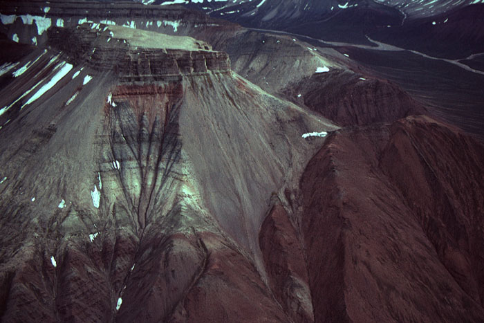
Fig. 2-11: A fault block with Devonian and unconformably overlying Carboniferous strata (left) displaced against Devonian (right) at Triungen (northwestern Dickson Land). Carboniferous strata include Hørbyebreen and Mumien formations (light and grey), Hultberget Formation (upper red band) and Wordiekammen Formation (uppermost cliff). Photo: W.K. Dallmann THICKNESS: Up to 2500 m (cumulative) MAIN LITHOLOGIES: Sandstone, shale, conglomerate DESCRIPTION: Clastic sediments with local coal seams, bound to a number of tectonic depressions developed subsequent to the deposition of Old Red sediments. The group comprises the Hørbyebreen and Mumien formations of the Billefjorden–Ny Friesland area, the Orustdalen and Vegardfjella formations of western Spitsbergen, the Adriabukta, Hornsundneset and Sergeijevfjellet formations of the Sørkapp-Hornsund area, the Røedvika and Nordkapp formations of Bjørnøya and time/facies equivalents of the Barents Sea Shelf. 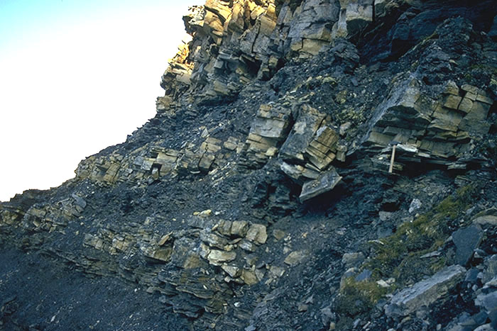
Fig. 2-12: Typical sediments of the Billefjorden Group at Billefjorden, representing delta plain and overbank deposits. Photo: E.P. Johannessen Back to top HØRBYEBREEN FORMATION (CP-02)  DISTRIBUTION: shown on Fig. 2-09
STATUS OF UNIT: Formal FIRST USE OF NAME: Cutbill & Challinor 1965 CURRENT DEFINITION: Cutbill et al. 1976 SYNONYM(S) AND REFERENCE(S): None ORIGIN OF NAME: Hørbyebreen: A glacier tongue ending in the inner part of Billefjorden, central Spitsbergen TYPE SECTION (Fig. 2-15): Stratotype: Ferdinandbreen, Dickson Land STRUCTURAL SETTING: Early Carboniferous basin in central and northern Spitsbergen, plunging southward below younger strata; mainly preserved in the middle Carboniferous Billefjorden Trough DEPOSITIONAL AGE: Famennian - Viséan DATING METHOD: Palynology 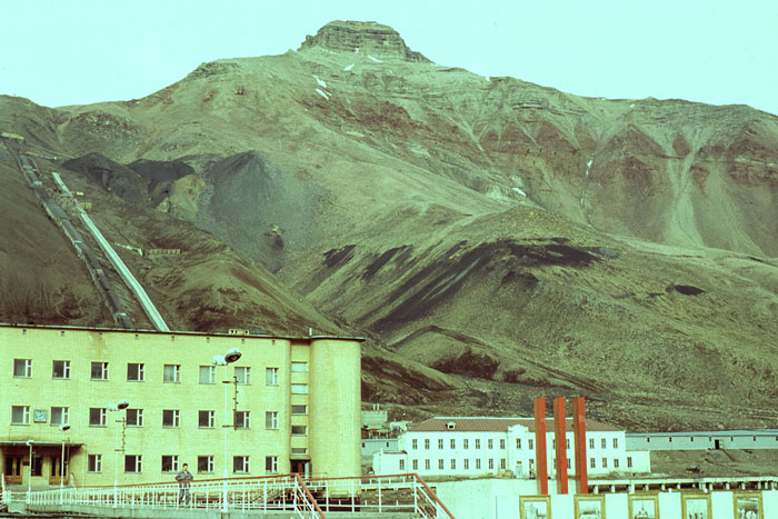
Fig. 2-13: The Russian coal mining settlement Pyramiden (recently abandoned) with transportation facilities to the mine in the mountain side. The coal seams occur in the Hørbyebreen and Mumien formations in a fault block displaced against the strata in the mountain Pyramiden (background). The mountain side shows the Ebbadalen Formation with the red-coloured conglomerates of the Odellfjellet Member, overlying sandstones of the Minkinfjellet Formation, and limestones of the Wordiekammen Formation (uppermost cliff). Photo: J. Nagy OVERLYING UNIT(S): Mumien Formation UNDERLYING UNIT(S): Andrée Land Group, Pre-Old Red SUPERIOR UNIT: Billefjorden Group OTHER USE OF NAME: None THICKNESS: Up to 200 m, >140 m in stratotype MAIN LITHOLOGIES: Sandstone, conglomerate, coal LOWER BOUNDARY DEFINITION: Angular unconformity, with greyish sandstones or conglomerates overlying folded basement strata or folded or tilted sediments of the Devonian Wood Bay or Mimerdalen formations DESCRIPTION: The Hørbyebreen Formation occurs between Dicksonfjorden and Nordenskiöldbreen, with good exposures in the Billefjorden Trough between Billefjorden and Austfjorden. The formation is also present in Ny Friesland forming a few down-faulted outliers along the western margin of the Ny Friesland Block. 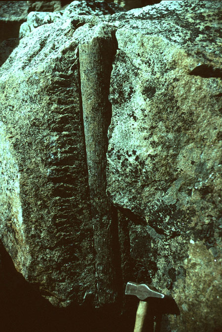
Fig. 2-14: Sigillaria stems are common in the deposits of the Billefjorden Group; here at Lemstrømfjellet (southwestern Ny Friesland). Photo: W.K. Dallmann 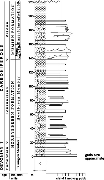
Fig. 2-15: Stratigraphic section CP-02/04 Stratotype for: Hørbyebreen Formation, Hoelbreen Member Locality: Ferdinandbreen (Mumien NE) Reference: Gjelberg, J.G. (unpubl.) Triungen Member (CP-03) STATUS OF UNIT: Formal FIRST USE OF NAME: Cutbill & Challinor 1965 CURRENT DEFINITION: Cutbill et al. 1976 SYNONYM(S) AND REFERENCE(S): None ORIGIN OF NAME: Triungen (Norw. from "Mt. Triplex"): A mountain in NW Dickson Land TYPE SECTION (Fig. 2-18): Stratotype: Triungen West, Dickson Land DEPOSITIONAL AGE: Famennian 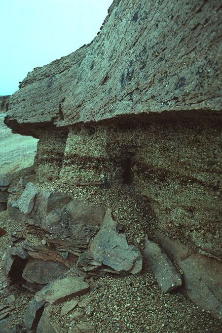
Fig. 2-16: Gravelstones and crossbedded sandstones in the basal part of the Triungen Member on Ålen (Dickson Land). Photo: W.K. Dallmann DATING METHOD: Palynology REFERENCE(S) FOR AGE: Playford 1962, 1963; Kaiser 1970, 1971; Vigran 1994 (unpubl.); Veen, P. van (unpubl. data) OVERLYING UNIT(S): Hoelbreen Member UNDERLYING UNIT(S): Andrée Land Group, Pre-Old Red SUPERIOR UNIT: Hørbyebreen Formation OTHER USE OF NAME: Triungen-Grønhorgdalen Fault Zone Triungen Fault (McCann & Dallmann 1996) THICKNESS: 130 m in stratotype MAIN LITHOLOGIES: Sandstone, conglomerate, shale LOWER BOUNDARY DEFINITION: See Hørbyebreen Formation DESCRIPTION: The Triungen Member consists mainly of grey sandstones and conglomerates (Fig. 2-16, Fig. 2-17). 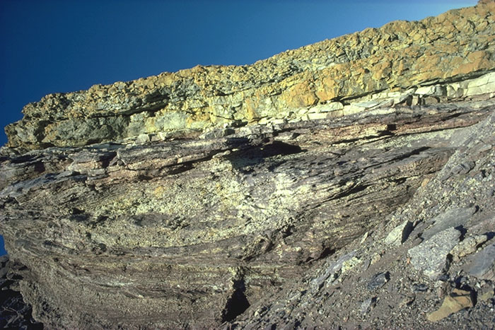
Fig. 2-17: Alluvial fan deposits with reworked, light sandstone in the Triungen Member on Faraofjellet (Dickson Land). Photo: E.P. Johannessen There are, however, some thick units of grey/greyish purple shale, interbedded with thin sandstones, in the type section at Triungen. It is also reported that fine-grained sediments are relatively common at other localities, though poorly exposed. The member probably represents fluvial and lacustrine depositional environments. 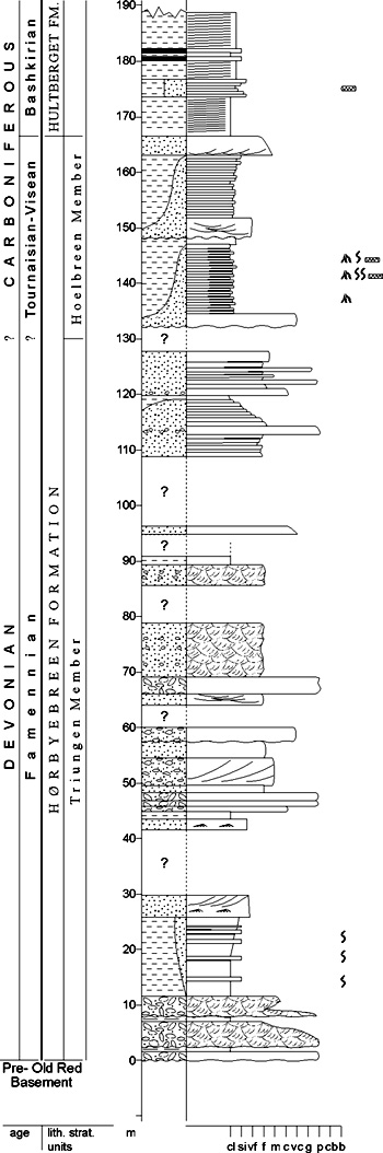
Fig. 2-18: Stratigraphic section CP-03 Stratotype for: Triungen Member Locality: Triungen W Reference: Gjelberg, J.G. (unpubl.) Palynological material studied by Playford (1962, 1963), and reinterpreted by P. van Veen (unpubl.) and Vigran 1994 (unpubl.), suggests an upper Devonian (Famennian) age of the member, corresponding in age with the Røedvika Fm. on Bjørnøya (based on comparisons with studies by Kaiser 1970, 1971 on Bjørnøya). There may be a stratigraphic break between the Triungen Member and the overlying Hoelbreen Member of Tournaisian age (P. van Veen, pers. comm. 1996; Vigran, 1994, unpubl.). Hoelbreen Member (CP-04) STATUS OF UNIT: Formal FIRST USE OF NAME: Cutbill & Challinor 1965 CURRENT DEFINITION: Cutbill et al. 1976 SYNONYM(S) AND REFERENCE(S): None ORIGIN OF NAME: Hoelbreen: A glacier in Dickson Land, NW of Billefjorden TYPE SECTION (Fig. 2-15): Stratotype: Ferdinandbreen, Dickson Land The stratotype was originally defined at the northwestern slope of Birger Johnsonfjellet (Cutbill & Challinor 1965), but no documentation is available. DEPOSITIONAL AGE: Tournaisian - Viséan DATING METHOD: Palynology REFERENCE(S) FOR AGE: Playford 1962, 1963; Nøttvedt et al. 1992; Vigran 1994 (unpubl.) OVERLYING UNIT(S): Mumien Formation UNDERLYING UNIT(S): Triungen Member SUPERIOR UNIT: Hørbyebreen Formation OTHER USE OF NAME: None THICKNESS: Up to 150 m, 110 m in stratotype MAIN LITHOLOGIES: Shale, sandstone, coal LOWER BOUNDARY DEFINITION: The lower boundary is defined at the onset of a shale-dominated succession above the sandstones of the Triungen Member. DESCRIPTION: The Hoelbreen Member consists generally of black to grey shales and mudstones with thinly interbedded ripple-laminated sandstones, coals and clay ironstones (siderite). Interbedded thin sandstones (2-50 cm) and thin mudstones are common lithological associations and may form up to several metre thick units. Only a few prominent sandstone units (3-5m thick) occur within the member. These sandstones represent fluvial channels. Coal seams occur at several levels; the thickest seams are located in the uppermost part of the member in the Pyramiden area. The member reflects deposition on flood plains and in flood basins with associated meandering and ribbon channels. Back to top MUMIEN FORMATION (CP-05) 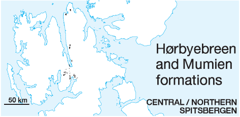 DISTRIBUTION shown on Fig. 2-09
STATUS OF UNIT: Formal FIRST USE OF NAME: Here CURRENT DEFINITION: Here SYNONYM(S) AND REFERENCE(S): The Mumien Formation comprises most of the "Svenbreen Formation" (Cutbill & Challinor 1965), though excluding the "Hultberget Member". ORIGIN OF NAME: Mumien (transl. "The Mummy"): A mountain in northeastern Dickson Land TYPE SECTION (Fig. 2-19): Stratotype: Northern slope of Birger Johnsonfjellet, Dickson Land STRUCTURAL SETTING: Early Carboniferous basin in central and northern Spitsbergen, plunging southward below younger strata; mainly preserved in the middle Carboniferous Billefjorden Trough DEPOSITIONAL AGE: Viséan DATING METHOD: Palynology REFERENCE(S) FOR AGE: Nøttvedt et al. 1992; Vigran 1994 (unpubl.); Veen, P. van (unpubl.) OVERLYING UNIT(S): Hultberget Formation; locally in the Billefjorden Fault Zone: Ebbadalen Formation, Wordiekammen Formation UNDERLYING UNIT(S): Hørbyebreen Formation; Pre-Old Red SUPERIOR UNIT: Billefjorden Group OTHER USE OF NAME: None THICKNESS: Up to 100 m, 95 m in stratotype MAIN LITHOLOGIES: Sandstone, shale, coal LOWER BOUNDARY DEFINITION: The base of the formation is defined at the base of the prominent sandstones of the Sporehøgda Member (see below), which overlie various lithologies of the Hoelbreen Member. The boundary is easy to recognise within the Billefjorden Fault Zone. It is less distinct on the eastern side of Austfjorden and in central Dickson Land, where the sandstones of the Sporehøgda Mb. are less prominent and frequently interbedded with shales. 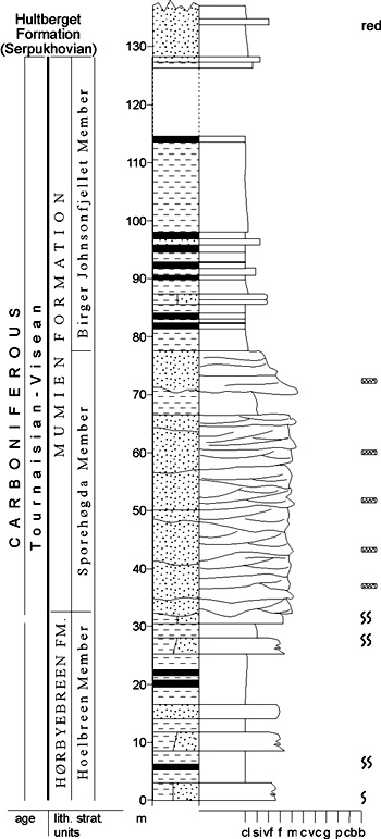
Fig. 2-19: Stratigraphic section CP-05/06/07. Stratotype for: Mumien Formation, Sporehøgda and Birger Johnsonfjellet members. Locality: Birger Johnsonfjellet N. Reference: Gjelberg 1984 (unpubl.) DESCRIPTION: The Mumien Formation consists of a lower, relatively thick sandstone interval and alternating black and grey shales and coals in the upper part. It is divided into two members, the Sporehøgda Member and the Birger Johnsonfjellet Member. Sporehøgda Member (CP-06) STATUS OF UNIT: Formal FIRST USE OF NAME: Cutbill & Challinor 1965 CURRENT DEFINITION: Cutbill et al. 1976 SYNONYM(S) AND REFERENCE(S): None ORIGIN OF NAME: Sporehøgda (transl. "The Spur Hill"): A mountain in northern Bünsow Land TYPE SECTION (Fig. 2-19): Stratotype: Ferdinandbreen, Dickson Land DEPOSITIONAL AGE: Viséan DATING METHOD: Palynology REFERENCE(S) FOR AGE: Nøttvedt et al. 1992; Vigran 1994 (unpubl.); Veen, P. van (unpubl.) OVERLYING UNIT(S): Birger Johnsonfjellet Mb. UNDERLYING UNIT(S): Hoelbreen Member; Pre-Old Red SUPERIOR UNIT: Mumien Formation OTHER USE OF NAME: None THICKNESS: Up to 90 m, 45 m in stratotype MAIN LITHOLOGIES: Sandstone, shale LOWER BOUNDARY DEFINITION: See Mumien Formation DESCRIPTION: The Sporehøgda Member contains several superimposed, metre- to ten-metre-scale, trough cross-stratified sandstone units. Individual units show slight gradation, and are often bounded by curved erosion surfaces. Several metres thick units of fine-grained material are preserved between sandstone sequences, especially in the northern part of the area. Plant fossils, mainly preserved as carbonaceous films and trunk casts or trunk impressions are common. Birger Johnsonfjellet Member (CP-07) STATUS OF UNIT: Formal FIRST USE OF NAME: Here; after Gjelberg 1984 (unpubl.) CURRENT DEFINITION: Here; after Gjelberg 1984 (unpubl.) SYNONYM(S) AND REFERENCE(S): None ORIGIN OF NAME: Birger Johnsonfjellet: A mountain in NE Dickson Land TYPE SECTION (Fig. 2-19): Stratotype: Birger Johnsonfjellet, Dickson Land DEPOSITIONAL AGE: Viséan DATING METHOD: Palynolgy REFERENCE(S) FOR AGE: Playford 1962, 1963; Nøttvedt et al. 1992; Vigran 1994 (unpubl.); Veen, P. van (unpubl.) OVERLYING UNIT(S): Hultberget Formation; in easternmost exposures: Minkinfjellet Formation; locally in the Billefjorden Fault Zone: Ebbadalen Formation, Wordiekammen Formation UNDERLYING UNIT(S): Sporehøgda Member SUPERIOR UNIT: Mumien Formation OTHER USE OF NAME: None THICKNESS: Up to 55 m, 51 m in stratotype MAIN LITHOLOGIES: Shale, siltstone, coal LOWER BOUNDARY DEFINITION: The lower boundary is defined where a shale-dominated succession overlies the sandstones of the Sporehøgda Member. DESCRIPTION: The Birger Johnsonfjellet Member consists mainly of black/grey shales, coaly shales and dark grey claystones, interbedded with thin siltstones (siderite bands) and coal. Plant root horizons are common, especially in the lower part of the member. Most of the coal seams are made up of algal material (Botryococcus) and may represent good source rocks for oil and gas (Abdullah et al. 1988). The member represents mainly flood-basin and lake deposits and becomes more flood-plain dominated eastwards. Back to top ORUSTDALEN FORMATION (CP-08) 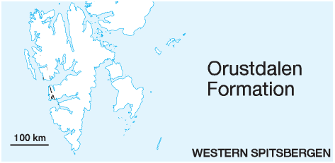 DISTRIBUTION shown on Fig. 2-07, Fig. 2-08
STATUS OF UNIT: Formal FIRST USE OF NAME: Cutbill & Challinor 1965 CURRENT DEFINITION: Cutbill & Challinor 1965 SYNONYM(S) AND REFERENCE(S): None ORIGIN OF NAME: Orustdalen: A valley in western Nordenskiöld Land, Western Spitsbergen TYPE SECTION (Fig. 2-21): The base of the section is not exposed. The previously defined stratotype at Orustdalen (Cutbill & Challinor 1965) is not logged. Hypostratotype: Diabasbukta, Bellsund. Both sections are tectonically disturbed (Braathen & Bergh 1995). STRUCTURAL SETTING: Early Carboniferous basin in western Spitsbergen; connection with other coeval basins not documented DEPOSITIONAL AGE: ?Tournaisian - Viséan (?Serpukhovian) DATING METHOD: Palynology REFERENCE(S) FOR AGE: Cutbill & Challinor 1965; Fairchild 1982 OVERLYING UNIT(S): Brøggertinden Formation, Vegardfjella Formation, Treskelodden Formation UNDERLYING UNIT(S): Pre-Old Red SUPERIOR UNIT: Billefjorden Group OTHER USE OF NAME: None THICKNESS: Up to >700 m MAIN LITHOLOGIES: Sandstone, shale LOWER BOUNDARY DEFINITION: The lower boundary is an angular unconformity, with greyish sandstones, shales or conglomerates overlying folded Pre-Old Red basement. DESCRIPTION: The Orustdalen Formation is exposed in western Spitsbergen from Brøggerhalvøya in the north to Hornsund in the south. The formation is mainly composed of a complex stack of fining-upward units of different scale and thickness (Gjelberg 1984, unpubl.). These units often start with cross-stratified (planar and trough) pebbly sandstones and conglomerates and terminate in relatively thin shales. The facies associations indicate a braided stream and flood-plain fines origin. 
Fig. 2-20. Cross-bedded, light grey sandstones with tidal bundles occur frequently in the Orustdalen Formation, here at Bellsund. Photo: W.K. Dallmann. Back to top VEGARDFJELLA FORMATION (CP-09) 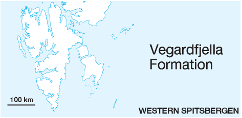 DISTRIBUTION shown on Fig. 2-07, Fig. 2-08
STATUS OF UNIT: Formal FIRST USE OF NAME: Dineley 1958 CURRENT DEFINITION: Cutbill & Challinor 1965 SYNONYM(S) AND REFERENCE(S): "Vegard Sandstone Formation", "Vegard Formation": The above mentioned authors did not use the complete place name. ORIGIN OF NAME: Vegardfjella: A mountain complex at St. Jonsfjorden, Oscar II Land, Western Spitsbergen TYPE SECTION (Fig. 2-21): The base of the section is not exposed. The suggested stratotype at Vegardfjella (Dineley 1958) is not logged. Cutbill & Challinor's (1965) revised type locality at Orustdalen is not documented. Until further documentation is provided, SKS does not decide which stratotype should be valid. Hypostratotype: Diabasbukta, Bellsund 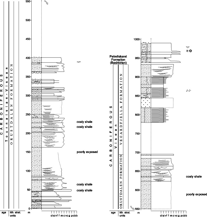
Fig. 2-21: Stratigraphic section CP-08/09 Hypostratotype for: Orustdalen and Vegardfjella formations. Locality: Diabasbukta. Reference: Gjelberg 1984 (unpubl.) STRUCTURAL SETTING: Early Carboniferous basin in western Spitsbergen; connection with other coeval basins not documented DEPOSITIONAL AGE: Viséan DATING METHOD: Palynology in adjacent units REFERENCE(S) FOR AGE: see Orustdalen Formation OVERLYING UNIT(S): Brøggertinden Formation, Petrellskaret Formation, Wordiekammen Formation UNDERLYING UNIT(S): Orustdalen Formation SUPERIOR UNIT: Billefjorden Group OTHER USE OF NAME: None THICKNESS: Up to >150 m. The suggested type section of Dineley (1958) in Orustdalen was reported to be 358 m thick. This interval also includes the redbeds of the overlying Petrellskaret Formation (Cutbill & Challinor 1965). MAIN LITHOLOGIES: Mudstone, sandstone, coaly shale LOWER BOUNDARY DEFINITION: The base of the formation is defined where the thick sandstones of the Orustdalen Formation transitionally grade upwards into the heterolithic, finer-grained sediments which dominate the Vegardfjella Formation. DESCRIPTION: The Vegardfjella Formation ("Vegard Sandstone Formation") was first named by Dineley (1958), who described "thinly bedded, pinkish, quartzose sandstones and thin shales". It was redefined by Cutbill & Challinor (1965). Back to top ADRIABUKTA FORMATION (CP-10) 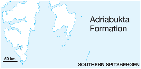 DISTRIBUTION shown on Fig. 2-06
STATUS OF UNIT: Formal FIRST USE OF NAME: Birkenmajer & Turnau 1962; rank revised to 'formation' by Cutbill & Challinor (1965) CURRENT DEFINITION: Dallmann et al. 1993 SYNONYM(S) AND REFERENCE(S): None ORIGIN OF NAME: Adriabukta: A bay in the Hornsund fiord, southern Spitsbergen TYPE SECTION (Fig. 2-22): Stratotype: Adriabukta (coastal section), Hornsund 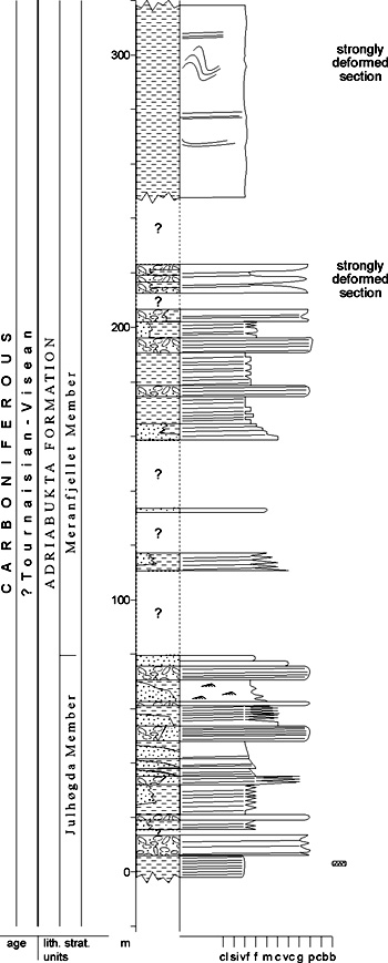
Fig. 2-22: Stratigraphic section CP-10/13. Stratotype for: Adriabukta Formation, Meranfjellet Member. Locality: Adriabukta. Reference: Gjelberg 1984 (unpubl.) STRUCTURAL SETTING: Early Carboniferous (?) basin in southern Spitsbergen, preserved in Samarinbreen Syncline DEPOSITIONAL AGE: Viséan, and/or possibly older: The Early Carboniferous age is based on only two samples with spore specimens of doubtful age-indicative value; a late Devonian age cannot be totally ruled out as yet. DATING METHOD: Palynology REFERENCE(S) FOR AGE: Birkenmajer & Turnau 1962 OVERLYING UNIT(S): Hyrnefjellet Formation, Hornsundneset Formation UNDERLYING UNIT(S): Marietoppen Formation, Pre-Old Red SUPERIOR UNIT: Billefjorden Group OTHER USE OF NAME: None THICKNESS: Up to 1750 m cumulative MAIN LITHOLOGIES: Shale, sandstone, conglomerate LOWER BOUNDARY DEFINITION: The lower boundary of the Adriabukta Formation in Sørkapp Land is placed at a distinct erosional unconformity over Caledonian folded basement. Its boundary with Devonian deposits is only exposed north of Hornsund, (Adriabukta) where it is apparently conformable. In the type section, the base is defined by an organic-rich black shale which overlies multicoloured Devonian shales and sandstones. DESCRIPTION: The basal black shale (see above) is overlain by grey sandstones and conglomerates (Julhøgda Member). Exceptionally, at the mountain Haitanna, thick conglomerates (Haitanna Member) form the base of the formation above crystalline basement. The upper part of the formation consists of a dark, shale-dominated succession (Meranfjellet Member). The upper boundary is defined by the unconformity towards the overlying red conglomerates of the middle Carboniferous Hyrnefjellet Formation north of Hornsund and, south of the fiord, by the tectonised boundary towards massive sandstones of the Hornsundneset Formation. Haitanna Member (CP-11) STATUS OF UNIT: Formal FIRST USE OF NAME: Dallmann 1992 CURRENT DEFINITION: Dallmann et al. 1993 SYNONYM(S) AND REFERENCE(S): None ORIGIN OF NAME: Haitanna (transl. "The Shark Tooth"): A mountain in central Sørkapp Land, southern Spitsbergen TYPE LOCALITY: Haitanna, Sørkapp Land DEPOSITIONAL AGE: Viséan or older (see Adriabukta Formation) DATING METHOD: Palynology in adjacent units REFERENCE(S) FOR AGE: Birkenmajer & Turnau 1962 OVERLYING UNIT(S): Julhøgda Member UNDERLYING UNIT(S): Pre-Old Red SUPERIOR UNIT: Adriabukta Formation OTHER USE OF NAME: None THICKNESS: ca. 450 m MAIN LITHOLOGIES: Conglomerate LOWER BOUNDARY DEFINITION: See Adriabukta Formation DESCRIPTION: The Haitanna Member forms the lower, conglomeratic part of the Adriabukta Formation, occurring only locally on the mountain Haitanna, where it constitutes the middle part of the massif and the summit (Fig. 2-23). It can be traced laterally for 2.3 km. It unconformably overlies ?Mid-Proterozoic garnet mica schists. 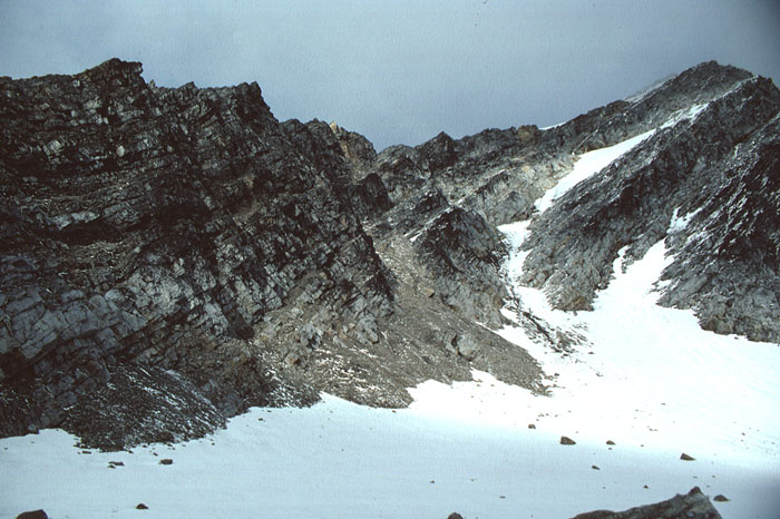
Fig. 2-23: The occurrence of thick alluvial fan conglomerates of the Haitanna Member is restricted to the mountain Haitanna ("The Shark Tooth"), central Sørkapp Land. Photo: W.K. Dallmann Julhøgda Member (CP-12) STATUS OF UNIT: Formal FIRST USE OF NAME: Dallmann et al. 1993 CURRENT DEFINITION: Dallmann et al. 1993 SYNONYM(S) AND REFERENCE(S): None ORIGIN OF NAME: Julhøgda (transl. "Christmas Peak"): A mountain at the Hornsund fiord in northern Sørkapp Land, southern Spitsbergen TYPE LOCALITY: JulhøgdaHaitanna, Sørkapp Land DEPOSITIONAL AGE: Viséan or older (see Adriabukta Formation) DATING METHOD: Palynology REFERENCE(S) FOR AGE: Birkenmajer & Turnau 1962 OVERLYING UNIT(S): Meranfjellet Member UNDERLYING UNIT(S): Haitanna Member, Pre-Old Red SUPERIOR UNIT: Adriabukta Formation OTHER USE OF NAME: None THICKNESS: Up to 700 m MAIN LITHOLOGIES: Sandstone, conglomerate LOWER BOUNDARY DEFINITION: Where situated above basement, see Adriabukta Formation. Where the Haitanna Member is present, the base of the Julhøgda Member is defined by the first dominance of sandstones above the Haitanna conglomerates. DESCRIPTION: The Julhøgda Member forms the middle part of the Adriabukta Formation. It consists mainly of sandstones with subordinate conglomerates and shales. 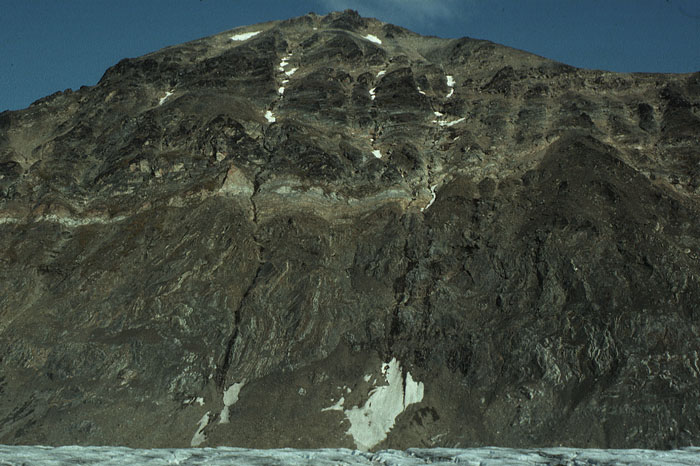
Fig. 2-24: Sandstones of the Julhøgda Member unconformably overlie Precambrian basement at Pinsetoppen (northern Sørkapp Land). The sandstones occur in the lower part of the slope and dip slightly steeper than the slope towards the observer. Photo: W.K. Dallmann Meranfjellet Member (CP-13) STATUS OF UNIT: Formal FIRST USE OF NAME: Dallmann et al. 1993 CURRENT DEFINITION: Dallmann et al. 1993 SYNONYM(S) AND REFERENCE(S): None ORIGIN OF NAME: Meranfjellet: A mountain near the Hornsund fiord in northern Sørkapp Land, southern Spitsbergen TYPE SECTION (Fig. 2-22): Stratotype: Adriabukta (coastal section), Hornsund DEPOSITIONAL AGE: Viséan or older (see Adriabukta Formation) DATING METHOD: Palynology REFERENCE(S) FOR AGE: Birkenmajer & Turnau 1962 OVERLYING UNIT(S): Hyrnefjellet Formation, Hornsundneset Formation UNDERLYING UNIT(S): Julhøgda Member SUPERIOR UNIT: Adriabukta Formation OTHER USE OF NAME: None THICKNESS: 300-600 m MAIN LITHOLOGIES: Shale, siltstone, sandstone LOWER BOUNDARY DEFINITION: The lower boundary of the Meranfjellet Member is defined where a dark siltstone- and shale-dominated succession overlies dark, but light weathering quartzitic sandstones and coarse conglomerates of the Julhøgda Member. DESCRIPTION: The Meranfjellet Member consists of dark or silty shales and siltstones with subordinate sandstones and conglomerates, similar to those of the Julhøgda Member. The thickness is ca. 300 m in the type section at Adriabukta, but a more complete development (ca. 600 m) with a higher amount of sandstone intercalations has been observed at Meranfjellet. Due to intense folding and thrusting of the Meranfjellet exposures, the internal stratigraphic succession is uncertain, and the indicated thickness values are very rough. Back to top HORNSUNDNESET FORMATION (CP-14) 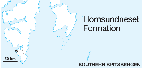 DISTRIBUTION shown on Fig. 2-06
STATUS OF UNIT: Formal FIRST USE OF NAME: Siedlecki 1960; rank revised to 'formation' by Cutbill & Challinor (1965) CURRENT DEFINITION: Birkenmajer 1979 SYNONYM(S) AND REFERENCE(S) "Hornsundneset Beds": Siedlecki 1960 ORIGIN OF NAME: Hornsundneset (transl. "Horn Sound Point": The coastal plain forming the NW tip of Sørkapp Land (type area) TYPE SECTION (Fig. 2-25): Stratotype: Hohenlohefjellet, east of Hornsundneset, Sørkapp Land. The base of the formation is not exposed in this section, but in Andvika a little further to the NNE. 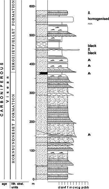
Fig. 2-25: Stratigraphic section CP-14. Stratotype for: Hornsundneset Formation. Locality: Hohenlohefjellet. Reference: Wendorff 1985 STRUCTURAL SETTING: Early Carboniferous basin in southern Spitsbergen; connection with other coeval basins not documented DEPOSITIONAL AGE: Viséan DATING METHOD: Palynology REFERENCE(S) FOR AGE: Siedlecki & Turnau 1964 OVERLYING UNIT(S): Sergeijevfjellet Formation, Hyrnefjellet Formation. Vardebukta Formation UNDERLYING UNIT(S): Adriabukta Formation, Pre-Old Red SUPERIOR UNIT: Billefjorden Group OTHER USE OF NAME: None THICKNESS: 700-1100 m, 370 m in stratotype MAIN LITHOLOGIES: Sandstone LOWER BOUNDARY DEFINITION: Angular unconformity either above folded rocks of the Pre-Old Red or above the dark shales of the Adriabukta Formation (?"Adriabukta event"). The base of the Hornsundneset formation in the Hornsundneset area is commonly defined by a thin quartz conglomerate. DESCRIPTION: The Hornsundneset Formation occurs in two different areas and structural regimes in Sørkapp Land: (1) gently inclined, overlying the Caledonian basement in the Hornsundneset area, and (2) steeply inclined to overturned within the foldbelt between Bladegga and Gråtinden. Other, minor occurrences are suggested underlying folded Permian strata at øyrlandsodden and Sørkappøya. The Hornsundneset Formation of the Hornsundneset area has been described by De Geer (in Nathorst 1910), Orvin (1940), Siedlecki 1960, Birkenmajer (1964, 1979a), Haczewski (1984), Liparski & Cґmiel (1984) and Wendorff (1985). Detailed stratigraphic investigations were published by Siedlecki (1960) and Wendorff (1985). Back to top SERGEIJEVFJELLET FORMATION (CP-15) 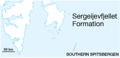 DISTRIBUTION shown on Fig. 2-06
STATUS OF UNIT: Formal FIRST USE OF NAME: Siedlecki 1960; rank revised to 'formation' by Cutbill & Challinor (1965) CURRENT DEFINITION: Siedlecki 1960 SYNONYM(S) AND REFERENCE(S): "Sergeijevfjellet Beds": Siedlecki 1960 ORIGIN OF NAME: Sergeijevfjellet: A mountain to the east of Hornsundneset, NW Sørkapp Land (type locality) TYPE SECTION (Fig. 2-26): Stratotype: Sergeijevfjellet, E of Hornsundneset, S Spitsbergen. STRUCTURAL SETTING: Early Carboniferous basin in southern Spitsbergen; connection with other coeval basins not documented 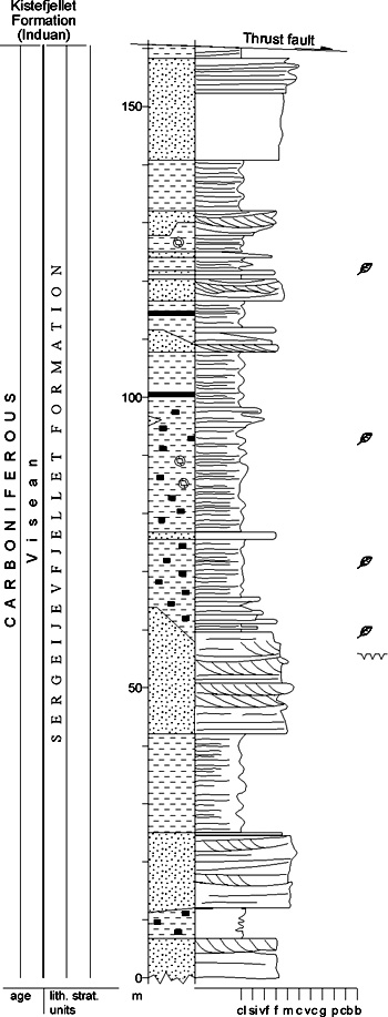
Fig. 2-26: Stratigraphic section CP-15. Stratotype for: Sergeijevfjellet Formation. Locality: Sergeijevfjellet. Reference: Gjelberg 1984 (unpubl.) DEPOSITIONAL AGE: Viséan DATING METHOD: Palynology REFERENCE(S) FOR AGE: Siedlecki & Turnau 1964 OVERLYING UNIT(S): Vardebukta Formation, locally ?Hyrnefjellet Fm. UNDERLYING UNIT(S): Hornsundneset Formation SUPERIOR UNIT: Billefjorden Group OTHER USE OF NAME: None THICKNESS: Up to 260 m, 160 m in stratotype MAIN LITHOLOGIES: Sandstone, shale LOWER BOUNDARY DEFINITION: The base of the formation is defined above the tick sandstones of the Hornsundneset Formation, at the base of the first fining-upward sandstone unit that ends up with a distinct shale interval. On Hohenlohefjellet, the base is situated above a thick coal seam. DESCRIPTION: The Sergeijevfjellet Formation forms the upper, shale-rich part of the Billefjorden Group in the Hornsund area. The formation occurs exclusively in the Hornsundneset area (Hohenlohefjellet, Sergeijevfjellet, Lisbetdalen) and is cut by the sub-Triassic unconformity. Thin developments through basal parts of the unit are possibly preserved in the Austjøkulen-Kronglebreen area within the Cenozoic foldbelt segment of Sørkapp Land. The formation has been described by Siedlecki (1960), Birkenmajer (1964), Liparski & ґ Cmiel (1984) and Wendorff (1985). Back to top RØEDVIKA FORMATION (CP-16) 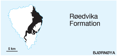 DISTRIBUTION shown on Fig. 2-05
STATUS OF UNIT: Formal FIRST USE OF NAME: Cutbill & Challinor 1965 CURRENT DEFINITION: Cutbill & Challinor 1965 SYNONYM(S) AND REFERENCE(S): "Ursa Sandstone", lower part: Holtedahl 1920 ORIGIN OF NAME: Røedvika: A bay on the E coast of Bjørnøya (type area) TYPE SECTION (Fig. 2-28): Composite section from localities along the E coast of Bjørnøya; see individual members (C-17,18,19) STRUCTURAL SETTING: Early Carboniferous basin of the Western Barents Sea Shelf DEPOSITIONAL AGE: Famennian - Tournaisian DATING METHOD: Palynology REFERENCE(S) FOR AGE: Kaiser 1970; Worsley & Edwards 1976; Vigran 1994 (unpubl.) OVERLYING UNIT(S): Nordkapp Formation, locally Kapp Hanna or Hambergfjellet formations. UNDERLYING UNIT(S): Pre-Old Red SUPERIOR UNIT: Billefjorden Group OTHER USE OF NAME: None THICKNESS: 120-360 m MAIN LITHOLOGIES: Sandstone, shale, coal LOWER BOUNDARY DEFINITION: The base of the formation is defined by the onset of clastic sediments, normally sandstones, above the main Caledonian angular unconformity and the erosive boundary with underlying folded or tilted rocks of the Pre-Old Red. DESCRIPTION: The Røedvika Formation represents the lower part of the Ursa Sandstone of earlier investigators. A detailed description was published by Horn & Orvin (1928). Worsley & Edwards (1976) subdivided the formation into the Vesalstranda, Kapp Levin and Tunheim members. 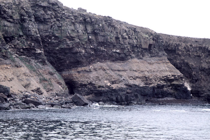
Fig. 2-27: Fluvial channel in the lower part of the Røedvika Formation, Røedvika, Bjørnøya. Photo: D. Worsley 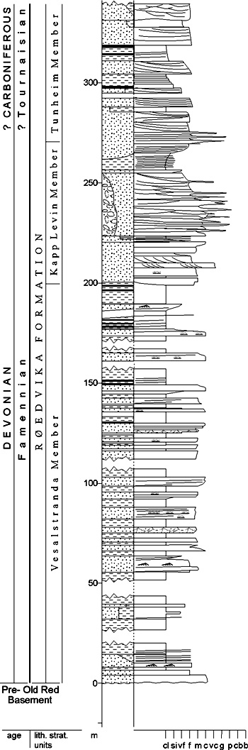
Fig. 2-28: Stratigraphic section CP-16. Composite stratotype for: Røedvika Formation. Locality: Vesalstranda - Kapp Levin - Tunheim. Reference: Gjelberg 1981 (unpubl.) Vesalstranda Member (CP-17) STATUS OF UNIT: Formal FIRST USE OF NAME: Worsley & Edwards 1976 CURRENT DEFINITION: Worsley & Edwards 1976 SYNONYM(S) AND REFERENCE(S): None. The unit is represented by the "Skrekk" and "Misery subformations" (Russ.: podsvity) of Pavlov et al. (1983). ORIGIN OF NAME: Vesalstranda: The coastal strip at the foot of Miseryfjellet, E coast of Bjørnøya (type locality) TYPE SECTION (Fig. 2-29): Stratotype: Vesalstranda, eastern Bjørnøya 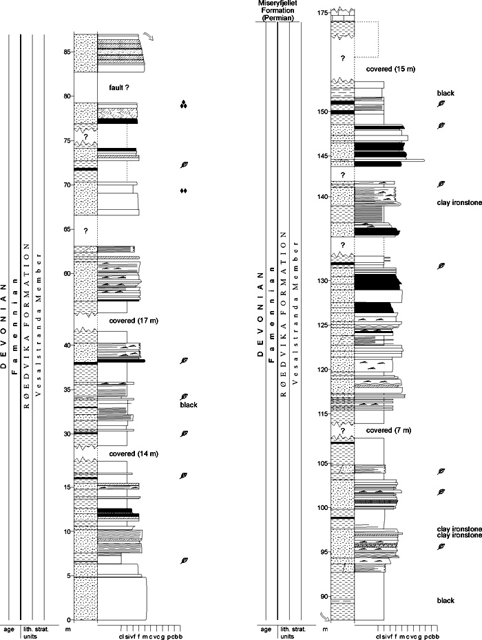
Fig. 2-29: Stratigraphic section CP-17. Stratotype for: Vesalstranda Member Locality: Vesalstranda. Reference: Gjelberg 1981 (unpubl.) DEPOSITIONAL AGE: Famennian DATING METHOD: Palynology REFERENCE(S) FOR AGE: Kaiser 1971; Worsley & Edwards 1976 OVERLYING UNIT(S): Kapp Levin Member UNDERLYING UNIT(S): Pre-Old Red SUPERIOR UNIT: Røedvika Formation OTHER USE OF NAME: None THICKNESS: ca. 200 m, >155 m in stratotype MAIN LITHOLOGIES: Sandstone, shale, coal LOWER BOUNDARY DEFINITION: See Røedvika Formation DESCRIPTION: The Vesalstranda Member consists of coarsening- and fining-upward units of sandstone, siltstone and shale. Coal seams and coaly shale are interbedded with these units. Siderite bands and concretions are often associated with the coals. Plant fossils are common, both within the shales and the sandstones. Kapp Levin Member (CP-18) STATUS OF UNIT: Formal FIRST USE OF NAME: Worsley & Edwards 1976 CURRENT DEFINITION: Worsley & Edwards 1976 SYNONYM(S) AND REFERENCE(S): None. The rank 'subformation' (Russ.: podsvita) was used by Pavlov et al. (1983). ORIGIN OF NAME: Kapp Levin: A cape on the eastern coast of Bjørnøya (type locality) TYPE SECTION (Fig. 2-30): Stratotype: Kapp Levin, eastern Bjørnøya 
Fig. 2-30: Stratigraphic section CP-18. Stratotype for: Kapp Levin Member Locality: Kapp Levin. Reference: Gjelberg 1981 DEPOSITIONAL AGE: Late Famennian - Early Tournaisian DATING METHOD: Palynology in over- and underlying units REFERENCE(S) FOR AGE: Vigran 1994 (unpubl.); Worsley & Edwards 1976 OVERLYING UNIT(S): Tunheim Member UNDERLYING UNIT(S): Vesalstranda Member SUPERIOR UNIT: Røedvika Formation OTHER USE OF NAME: None THICKNESS: 71 m in stratotype MAIN LITHOLOGIES: Sandstone, shale LOWER BOUNDARY DEFINITION: The lower boundary is defined at the base of the thick sandstone succession which dominates most of the unit. Conformably underlying lithologies are shales. DESCRIPTION: The lower part of the Kapp Levin Member consists of relatively thick, fining-upward sandstone units with lateral accretion surfaces. The overlying sandstones and pebbly sandstones reflect a more complex vertical development of alternating sandstones, pebbly sandstones, thin conglomerates and thin shales, probably representing braided stream deposits (Gjelberg 1981). The uppermost part of the member consists of a relatively thick mudstone interval coarsening upwards into conglomerates which constitute the lower part of the Tunheim Member. Tunheim Member (CP-19) STATUS OF UNIT: Formal FIRST USE OF NAME: Worsley & Edwards 1976 CURRENT DEFINITION: Worsley & Edwards 1976 SYNONYM(S) AND REFERENCE(S): None. The unit is represented by the "Tunheim" and "Fugle subformations" (Russ.: podsvity) of Pavlov et al. (1983) ORIGIN OF NAME: Tunheim: An abandoned coal mining settlement, NE Bjørnøya (type locality) TYPE SECTION (Fig. 2-31): Composite section: Rifleodden (lower part) and Tunheim (upper part), NE Bjørnøya 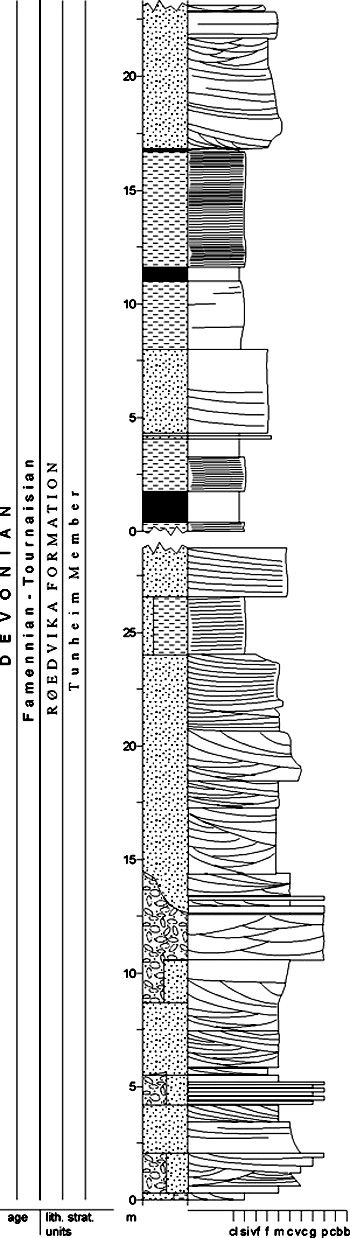
Fig. 2-31: Stratigraphic section CP-19. Composite stratotype for: Tunheim Member Locality: Tunheim (upper part) / Rifleodden (lower part). Reference: Gjelberg 1981 (unpubl.) DEPOSITIONAL AGE: Late Famennian - Early Tournaisian DATING METHOD: Palynology in adjacent units REFERENCE(S) FOR AGE: see Røedvika Formation OVERLYING UNIT(S): Nordkapp Formation UNDERLYING UNIT(S): Kapp Levin Member SUPERIOR UNIT: Røedvika Formation OTHER USE OF NAME: "Tunheim series" (Horn & Orvin 1928): lower, coal-bearing part of Tunheim Member; "Tunheim subformation" (Russ.: podsvita; Pavlov et al. 1983): lower part of Tunheim Member. The present definition of the Tunheim Member is wellestablished in the literature and has priority. THICKNESS: ca. 80 m MAIN LITHOLOGIES: Sandstone, shale, conglomerate, coal LOWER BOUNDARY DEFINITION: The lower boundary is defined at the conglomeratic base of the lowermost of the stacked fining-upward sequences that build up the member. The conformably underlying lithology is normaly sandstone. DESCRIPTION: The Tunheim Member starts with several metres thick conglomerate and pebbly sandstones defined as the "Rifleodden Conglomerate Bed" by Worsley & Edwards (1976), followed by a 20-30 m thick sandstone unit. The member is composed of 3-4 stacked, poorly defined, fining upward sequences, probably representing meandering streams (Gjelberg 1981). The internal organisation of the member is very complex, with several erosional surfaces and mudstone lenses. Back to top NORDKAPP FORMATION (CP-20) 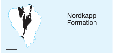 DISTRIBUTION shown on Fig. 2-05
STATUS OF UNIT: Formal FIRST USE OF NAME: Cutbill & Challinor 1965 CURRENT DEFINITION: Cutbill & Challinor 1965 SYNONYM(S) AND REFERENCE(S): "Ursa Sandstone", upper part: Holtedahl 1920 ORIGIN OF NAME: Nordkapp (transl. "North Cape"): A cape at the N coast of Bjørnøya TYPE SECTION (Fig. 2-32, Fig. 2-33): Unit stratotype: Landnørdingsvika , SW Bjørnøya Hypostratotype (upper part of formation): Nordhamna, N Bjørnøya. 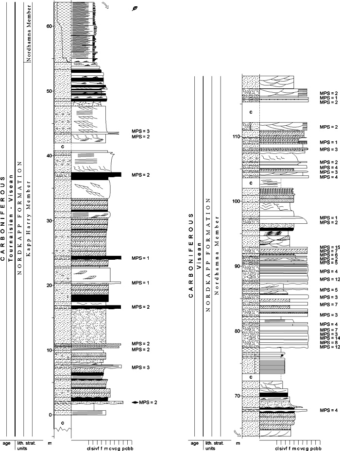
Fig. 2-32: Stratigraphic section CP-20a/21/22a. Unit stratotype for: Nordkapp Formation, Kapp Harry Member, Nordhamna Member. Locality: Landnørdingsvika. Reference: Gjelberg 1981 The base of the formation is not exposed at the type locality itself, but is found at several localities along the NE coast north of Tunheim (Worsley & Edwards 1976; Gjelberg 1981). STRUCTURAL SETTING: Early Carboniferous basin of the Western Barents Sea Shelf DEPOSITIONAL AGE: Tournaisian - Viséan DATING METHOD: Palynology REFERENCE(S) FOR AGE: Vigran 1994 (unpubl.); Worsley & Edwards 1976 OVERLYING UNIT(S): Landnørdingsvika Formation, locally Hambergfjellet Formation UNDERLYING UNIT(S): Røedvika Formation SUPERIOR UNIT: Billefjorden Group OTHER USE OF NAME: Nordkapp Basin (southern Barents Sea), from a different locality on mainland Norway THICKNESS: Up to 230 m MAIN LITHOLOGIES: Sandstone, conglomerate LOWER BOUNDARY DEFINITION: The base is defined at the onset of rapidly alternating clastic lithologies including conglomerates above the Røedvika Formation. Horn & Orvin (1928) describe a slight angular unconformity due to regional tilting of the underlying substratum. DESCRIPTION: The formation is divided into the Kapp Harry Member (below) and the Nordhamna Member (above). Kapp Harry Member (CP-21) STATUS OF UNIT: Formal FIRST USE OF NAME: Here; after Gjelberg 1984 (unpubl.) CURRENT DEFINITION: Gjelberg 1981 SYNONYM(S) AND REFERENCE(S): None ORIGIN OF NAME: Kapp Harry: A cape on the SW coast of Bjørnøya (type locality) TYPE SECTION (Fig. 2-32): Unit stratotype: Kapp Harry at Landnørdingsvika, SW Bjørnøya DEPOSITIONAL AGE: Tournaisian - ?Viséan DATING METHOD: Palynology REFERENCE(S) FOR AGE: Vigran 1994 (unpubl.) OVERLYING UNIT(S): Nordhamna Member UNDERLYING UNIT(S): Røedvika Formation SUPERIOR UNIT: Nordkapp Formation OTHER USE OF NAME: None THICKNESS: >50 m in stratotype MAIN LITHOLOGIES: Sandstone, conglomerate LOWER BOUNDARY DEFINITION: See Nordkapp Formation DESCRIPTION: The Kapp Harry Member consists mainly of medium-grained sandstone, dominated by planar and trough cross-stratification, with occasional beds of pebbly sandstone and thin conglomerates. Beds of mudstones (shales) and siltstones are scarce (1.6 %). Beds are usually distinctly lenticular. Soft-sediment deformation structures occur frequently. Nordhamna Member (CP-22) STATUS OF UNIT: Formal FIRST USE OF NAME: Here; after Gjelberg 1984 (unpubl.) CURRENT DEFINITION: Gjelberg 1981 SYNONYM(S) AND REFERENCE(S): None ORIGIN OF NAME: Nordhamna (transl. "North Harbour": A bay on the northern coast of Bjørnøya (locality of reference stratotype) TYPE SECTION (Fig. 2-32, Fig. 2-33): Unit stratotype: Landnørdingsvika , SW Bjørnøya Hypostratotype: Nordhamna, N Bjørnøya 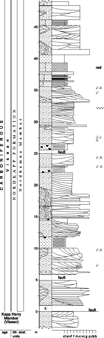
Fig. 2-33: Stratigraphic section CP-20b/22b. Hypostratotype for: Nordkapp Formation, Nordhamna Member. Locality: Nordhamna. Reference: Gjelberg 1981 DEPOSITIONAL AGE: Viséan DATING METHOD: Palynology in adjacent units REFERENCE(S) FOR AGE: See Nordkapp Formation OVERLYING UNIT(S): Landnørdingsvika Formation UNDERLYING UNIT(S): Kapp Harry Member SUPERIOR UNIT: Nordkapp Formation OTHER USE OF NAME: None THICKNESS: >65 m in stratotype MAIN LITHOLOGIES: Sandstone, conglomerate, shale LOWER BOUNDARY DEFINITION: The lower boundary of the member at the type locality is defined at the base of a prominent interval of alternating siltstone and shale (> 10 m thick), with conformably underlying sandstones of the Kapp Harry Member. DESCRIPTION: The Nordhamna Member consists of alternating cross stratified grey sandstones, pebbly sandstones, grey conglomerates (composed of quartzitic and chert pebbles) and grey or greyish-red siltstone and shale with thin coaly shale interbeds (Gjelberg 1981; Gjelberg & Steel 1981). Back to top |