 |
|
|
|
updated to follow: Stratigraphic Guide to the Cromer Knoll, Shetland and Chalk Groups of the North Sea and Norwegian Sea. Felix M. Gradstein & Colin C. Waters (editors), Mike Charnock, Dirk Munsterman, Michelle Hollerbach, Harald Brunstad, Øyvind Hammer & Luis Vergara (contributors). Newsletter on Stratigraphy, vol 49/1 pp71-280, 2016
Nebbhval Member | Spekkhogger Member
The term Nise Formation was introduced by Dalland et al. (1988) for a thick unit of predominantly non-calcareous marine mudstones between the Kvitnos and Springar Formations. It is typical for the Norwegian Sea region.
Two new sandstone members are defined within this formation: the Spekkhogger Member, an interval of thick sandstones found in the Vøring Basin, and the Nebbhval Member, a unit with a similar stratigraphic age developed in the Vestfjorden Basin. The age of the sands is Campanian. The new assignment and proper description of these siliciclastic reservoir units ends considerable stratigraphic and nomenclatorial confusion, and wrong application of the formation concept, in well completion reports and on the NPD ‘Facta siden’.
Derivatio nominis: The name Nise comes from the Norwegian for the harbour porpoise species Phocoena phocoena. This is a small, widespread, toothed whale (up to 2m long) found in both temperate coastal waters in the North Atlantic and colder latitudes of the North Sea, Norwegian Sea and westerly parts of the Barents Sea.
The Nise Formation mainly consists of mudstones with subordinate siltstones, sandstones and occasional carbonate stringers.
The mudstones are light - medium grey, occasionally green-grey or brown-grey, predominantly soft, plastic, occasionally blocky-firm, non to weakly calcareous, silty or occasionally sandy, and occasional grade to siltstone.
The siltstones are argillaceous, soft-firm, friable to loose with pyrite and glauconite.
The sandstone interbeds are light brown, very fine to fine, occasionally medium or coarse, clear quartz, sub- angular to sub-rounded grains, moderate to well sorted, predominantly loose, occasionally calcite cemented with glauconite, mica and pyrite.
The limestone stringers are white-grey, soft, occasionally argillaceous, micritic and occasionally sandy and the subordinate dolomite stringers are orange brown to light brown and firm to hard.

Regional isochore of the Nise Formation thickness in the Norwegian Sea based on released well data. The isochore map is generated from Norlex data using thin plate splines (thickness constrained to original range). Thicknesses in metres. Circled wells contain both top and base horizons. The red wells have Norlex biostratigraphy. Click for large version |
The Nise Formation is widely distributed in the Norwegian Sea area, notably in the Vøring Basin e.g. 6706/11-1, and on the Halten Dønna Terrace. Depo-centres are associated with the sandstones of the Spekkhogger Member in wells within the Vøring Basin, e.g. 6707/10-1, where the formation is typically more than 1000m thick.
The formation is either thin or absent along parts of the the Nordland Ridge, or on local highs e.g. 6507/8-5 (5.5m thick). A truncated Nise unit is located on the Omega Horst, Sør High. The Nise Formation is typically 100m - 200m thick in wells on the Halten – Dønna Terrace areas, and more thinly developed on the Trøndelags Platform.
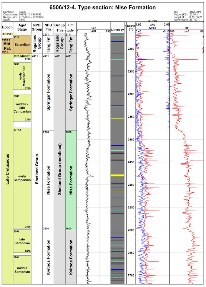
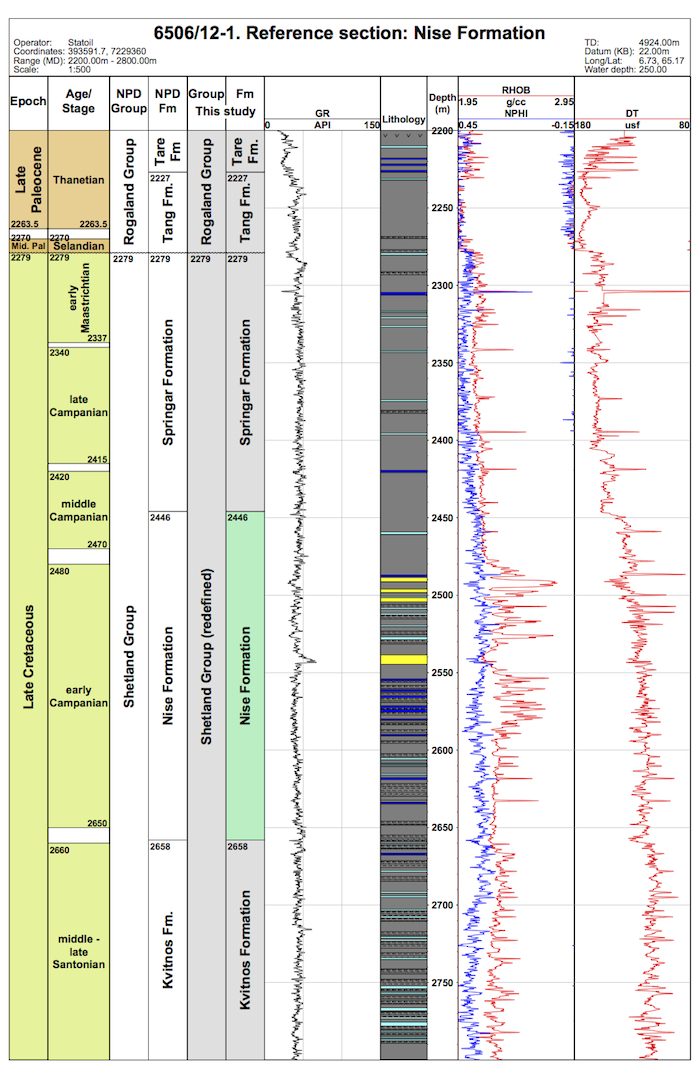
Reference well 6506/12-1: 35 slides (dc and 1 swc at 2582m) from samples covering the interval 2450m – 2645m (Stratlab, RRI and OD preparations) available at the Norwegian Petroleum Directorate.
No cores were taken in the Nise Formation in either the designated type 6506/12-4 or reference 6506/12-1 wells.
WGS84 coordinates: N 65°12'46.97, E 06°43'30.37 (figure 2)
UTM coordinates: 7234298.14 N 393591.29 E
UTM zone: 32
Drilling operator name: Den norske stats oljeselskap a.s. (Statoil a.s.)
Completion date: 13.08.1985
Status: P & A
Interval of type section (m) & thickness in type well (m):
2600m to 2380m and 220m thickness.
Click for large version (PDF)
WGS84 coordinates: N 65°10'07.58, E 06°43'44.07 (figure 2)
UTM coordinates: 7229359.52 N 393591.68 E
UTM zone: 32
Drilling operator name: Den norske stats oljeselskap a.s. (Statoil a.s.)
Completion date: 06.02.1985
Status: P & A
Interval of reference section (m) & thickness in reference well (m): 2658m -
2446m, 212m thickness.
Click for large version (PDF)
In mudstone dominated intervals of the Halten and Dønna Terrace areas, the stepwise shift in average sonic velocity values allows the Kvitnos, Nise and Springar Formations to be distinguished relatively easily. These trends probably reflect compaction trends within broad, marine mudstones depositional units. The boundaries may reflect periods of still-stand or regionally transgressive events, since the formation boundaries appear to be broadly synchronous within the region.
Within these mudstone dominated intervals on the margins of the Vøring Basin, there also is a subtle upward decrease in average gamma ray values near the base of the Nise Formation. The latter may reflects deposition of sandstone into the basin. Towards the top of the formation, but not coincident with the velocity change defining the upper boundary, is an increase in gamma-ray values e.g. in well 6506/12-1 at 2475m, that probably reflects the decrease in basinward sandstone deposition. This appears to occur close to the local lower /middle Campanian boundary. A prominent high gamma ray spike within the formation is identified as a regionally correlatable tuff horizon, e.g. in well 6506/12-1 at 2542m.
Biostratigraphic data is generally poor in the type well 6506/12-4. However, the base of the Nise Formation appears to be close to the Santonian/Campanian boundary, being closely associated with the (down-section) influx of the planktonic bivalve Inoceramus typical of a Santonian age (Zone NCF15). This influx is probably related to the downward development of more calcareous mudstones. Support is provided by the earliest Campanian dinocyst marker LO Spongodinium ‘cristatum’ in the basal part of the formation.
The upper boundary of this formation appears to be in Zone NCF 16 and 17, close to the early/middle Campanian boundary being between between the dinocyst markers LO Callaiosphaeridium asymetricum and LAO Trithyrodinium suspectum. The top abundant record (LAO) Trithyrodinium suspectum is a key marker near the top of the Nise Formation.The Nise Formation was generally deposited in a deep, bathyal paleoenvironment under restricted water circulation, developed in response to a deep but narrow seaway between Norway and Greenland, connecting the area to the Atlantic oceanic realm (Gradstein et al., 1999). Deeper water, non-calcareous agglutinated Foraminifera (DWAF) dominate the microfossil assemblage, with a composition similar to correlative assemblages in the North Atlantic. Diatoms are abundant at certain levels; all shells are pyritized, as would be expected at this burial depth.
Færseth, R. and Lien, T. 2002 Cretaceous evolution in the Norwegian Sea – a period characterized by tectonic quiescence. Marine and Petroleum Geology, 19, 1005 –1027.
Gradstein, F., Kaminski, M.A. and Agterberg, F.P. 1999. Biostratigraphy and paleoceanography of the Cretaceous seaway between Norway and Greenland. Earth-Science Reviews, 46, 27-98.
Swiecicki, T., Gibbs, P.B., Farrow, G.E. and Coward, M.P. 1998. A tectonostratigraphic framework for the Mid-Norway region. Marine and Petroloeum Geology, 15, 245-276.
Vergara, L., Wreglesworth, I., Trayfoot, M., Richardsen, G. 2001. The distribution of
Cretaceous and Paleocene deep-water reservoirs in the Norwegian Sea basins. Petroleum
Geoscience, 7, 395-408.
| home | previous page |