 |
|
|
|
updated to follow: Stratigraphic Guide to the Cromer Knoll, Shetland and Chalk Groups of the North Sea and Norwegian Sea. Felix M. Gradstein & Colin C. Waters (editors), Mike Charnock, Dirk Munsterman, Michelle Hollerbach, Harald Brunstad, Øyvind Hammer & Luis Vergara (contributors). Newsletter on Stratigraphy, vol 49/1 pp71-280, 2016
Kvitskjæving Member | Tumler Member
Derivatio nominis: Kvitnos is the Norwegian name for the white-beaked dolphin or Lagenorynchus albirostris. This small (up to 3m long) 'springar-type' species is found in flocks up to 30 individuals over large parts of the north Atlantic, around the British Isles and the Norwegian and Barents Seas, primarily in shallow coastal areas, in contrast to the closely related Kvitskjæving, which is found in deeper waters.
The Kvitnos Formation consists predominantly of calcareous mudstones with subordinate carbonate and sandstone stringers (Dalland et al., 1988). The mudstones are light-medium grey, green-grey, occasional medium-dark grey, soft, plastic, amorphous, occasional firm to blocky, subfissile, slightly to moderately calcareous and slightly silty. The limestone stringers are grey-white, occasionally light brown, soft to moderately hard, occasionally argillaceous and micritic. The dolomite stringers are light brown to light orange brown, moderately hard to hard. The thin sand beds are predominantly loose, light grey-white, very fine to fine, occasionally coarse, clear translucent quartz, sub-rounded to subangular, sub-spherical, well sorted, and occasionally weakly calcite cemented.
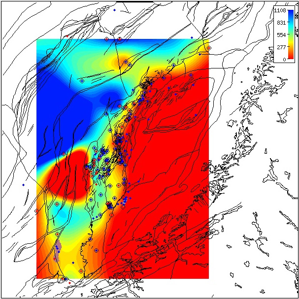
Regional isochore of the Kvitnos Formation thickness in the Norwegian Sea based on released well data. The isochore map is generated from Norlex data using thin plate splines (thickness constrained to original range). Thicknesses in metres. Circled wells contain both top and base horizons. The red wells have Norlex biostratigraphy. Click for large version. |
Reference well 6506/12-1: 75 slides (dc and 2 swc samples) covering the interval 2660 m dc - 3170 m dc (Stratlab, RRI and OD preparations) deposited at the Norwegian Petroleum Directorate.
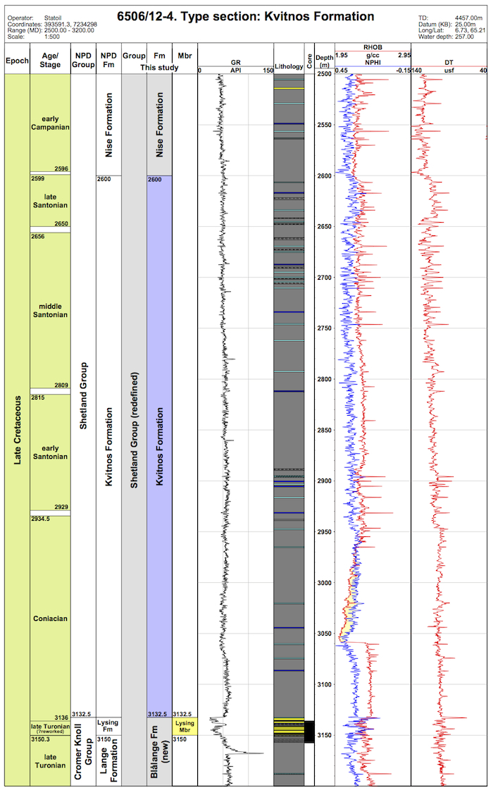
Type well 6506/12-4 (click to enlarge)
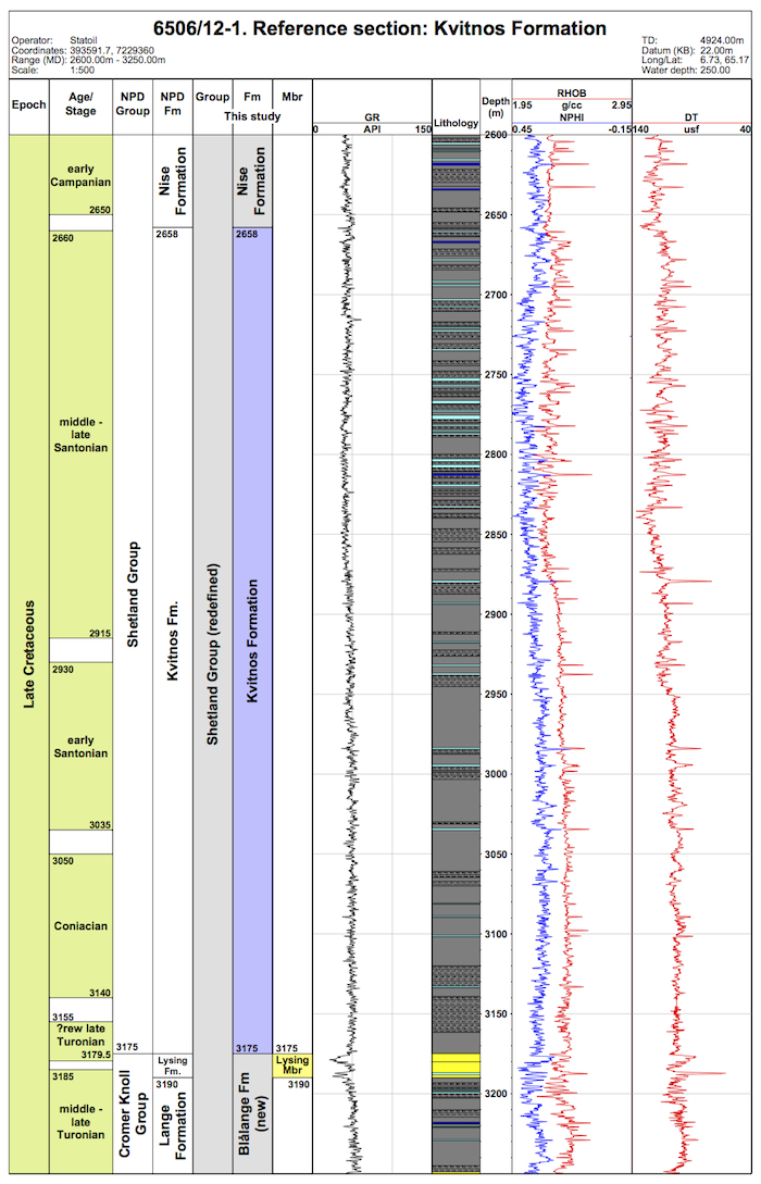
Reference well 6506/12-1 (click to enlarge)
The base of the Kvitnos Formation is normally taken at a downward change from calcareous mudstones to non-calcareous mudstones of the Blålange Formation or local sandstones of the Lysing Member. It is marked on logs by a downward decrease in average gamma-ray values and increase in average sonic velocity (Figure 3.26). Dalland et al. (1988) also noted a corresponding downward increase in resistivity values (typically when associated with the underlying Lysing member).
The Kvitnos Formation has a relatively uniform profile on gamma-ray logs reflecting the deposition of marine mudstones. However, the formation can be sub-divided into a series of regionally correlatable units based on the sonic log. A downward increase in average sonic velocity within the lower part of the formation appears to coincide with the Santonian/Coniacian boundary as defined on biostratigraphy, and provides an important regional log feature informally denoted k66 e.g. in well 6506/12-1 at 3033 m. This provides well log control prior to the penetration of Lysing sandstones. Similarly, higher in the formation at approximately the mid-point, there is another downward increase in average sonic velocity that appears to be close to the early/middle Santonian boundary and is informally named k68, e.g. in 6506/12-1 at 2950 m. Above this event sonic velocities appear to be more irregular than those in the lower part of the formation, and may reflect the increased frequency of sandstones.
The lower boundary of the Kvitnos Formation is above the Turonian dinocyst markers LO Stephodinium coronatum and Cyclonephelium membraniphorum. The lower part of the Kvitnos Formation is characterised by a marked increase in Heterosphaeridium difficile and Palaeoperidinium pyrophorum.
As indicate above in the well log character, within the Kvitnos Formation are some discrete, regionally identifiable units defined on the sonic log. The Coniacian/Santonian boundary, as defined by the LO Florentina deanei and more reliably, a marked down-section increase in Chatangiella 'spinosa', that is close to the informal surface k66 defined on sonic logs.
Dalland et al. (1988) had a Turonian - Santonian age range in their definition of the formation. The lower boundary is generally close to but above the Turonian/Coniacian stage boundary, i.e. earliest Coniacian, and the upper boundary is broadly coincident with that of the Santonian/Campanian stage boundary, within the limits of the available dinoflagellate cyst biostratigraphy.
The Kvitnos Formation is laterally equivalent to the middle part of the Kyrre Formation developed in the Shetland Group of the northern North Sea. It also is a lateral equivalent of the Thud and upper Narve Formations (formerly part of the Hod Formation) in the Chalk province of the North Sea.
Færseth, R. and Lien, T. 2002 Cretaceous evolution in the Norwegian Sea - a period characterized by tectonic quiescence. Marine and Petroleum Geology, 19, 1005 -1027.
Gradstein, F., Kaminski, M.A. and Agterberg, F.P. 1999. Biostratigraphy and paleoceanography of the Cretaceous seaway between Norway and Greenland. Earth-Science Reviews, 46, 27-98.
Swiecicki, T., Gibbs, P.B., Farrow, G.E. and Coward, M.P. 1998. A tectonostratigraphic framework for the Mid-Norway region. Marine and Petroleum Geology, 15, 245-276.
Vergara, L., Wreglesworth, I., Trayfoot, M., Richardsen, G. 2001. The distribution of Cretaceous and
Paleocene deep-water reservoirs in the Norwegian Sea basins. Petroleum Geoscience, 7, 395-408.
| home | previous page |