|
|
|
|
|
from: Dallmann. W.K. (ed.). Svalbard lithostratigraphic lexicon
[ Firkanten Formation | Basilika Formation | Grumantbyen Formation | Frysjaodden Formation | Hollendardalen Formation ]
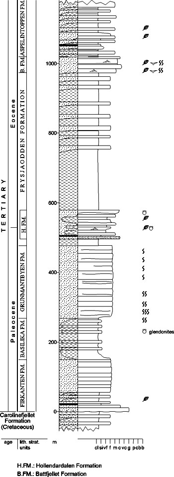
[ Battfjellet Formation | Aspelintoppen Formation | Ny-Ålesund Subgroup | Kongsfjorden Formation | Brøggerbreen Formation ] VAN MIJENFJORDEN GROUP (T-01) 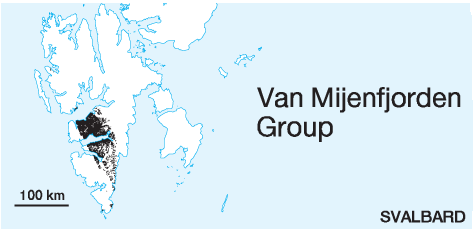 STATUS OF UNIT: Formal FIRST USE OF NAME: Harland 1969 CURRENT DEFINITION: Harland 1969; extended here to include the Ny-Ålesund Subgroup SYNONYM(S) AND REFERENCE(S): None ORIGIN OF NAME: Van Mijenfjorden: A fiord in southcentral Spitsbergen TYPE AREA (fig. 4-10): Southern coastal areas of Van Mijenfjorden, south-central Spitsbergen STRUCTURAL SETTING: Preserved mainly in the post-depositionally formed Central Cenozoic Basin, and in a tectonic block within the West Spitsbergen Fold-thrust Belt on Brøggerhalvøya (Kongsfjorden area) DEPOSITIONAL AGE: Paleocene-Eocene (? to Oligocene) Earlier interpretations of Miocene age of the Cenozoic of Spitsbergen (Heer 1868, 1870) have been questioned since the bivalve work of Ravn (1922) and are directly negated by the results of modern palynological and micropalaeontological studies (Manum & Throndsen 1986; Nagy, pers. comm. 1998). Livšics (1973, 1974) age determinations based on invertebrates, plant remains and palynology, are in general slightly younger than those suggested by the Norwegian workers for the middle and upper parts of the Van Mijenfjorden Group. OVERLYING UNIT(S): None UNDERLYING UNIT(S): Adventdalen Group; in Kongsfjorden area: Sassendalen or Tempelfjorden Group SUPERIOR UNIT: None OTHER USE OF NAME: None THICKNESS: Up to 1900 m preserved MAIN LITHOLOGIES: Sandstone, siltstone, shale DESCRIPTION: The Van Mijenfjorden Group is a clastic sedimentary succession consisting of sandstones, siltstones, shales and subordinate coals and conglomerates. It comprises all Cenozoic sediments in the Central Cenozoic Basin of Spitsbergen (figs. 4-08, 4-09), including Cenozoic exposures on øyrlandet and Erdmannflya, and the Ny-Ålesund Subgroup of the Kongsfjorden area. For descriptions see Firkanten, Basilika, Grumantbyen, Frysjaodden, Hollendardalen, Battfjellet, Aspelintoppen, Kongsfjorden and Brøggerbreen formations. The basal Firkanten Formation of the Van Mijenfjorden Group contains the most important coal deposits of Svalbard (Longyearbyen, Barentsburg and Sveagruva; fig. 4-08). The upper part of the Van Mijenfjorden Group is a presumable time equivalent to the lower part of the Buchananisen Group of the Forlandsundet Graben. The overlap includes the Battfjellet and Aspelintoppen formations (Steel et al. 1985) and possibly also the Frysjaodden Formation (Gilsonryggen Member; Livšic 1967, 1974). The Firkanten and Basilika formations are thought to be correlative with the Kongsfjorden and Brøggerbreen formations (Midbøe 1985. FIRKANTEN FORMATION (T-02) 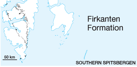
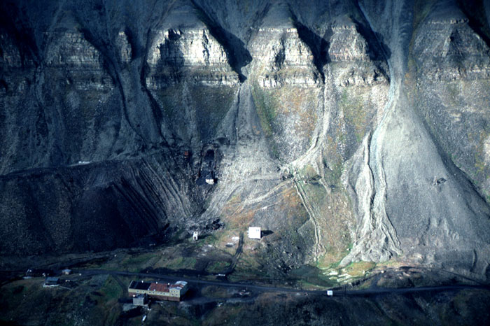
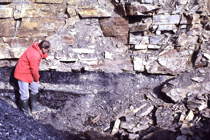
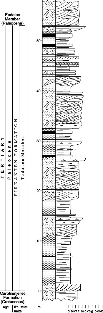
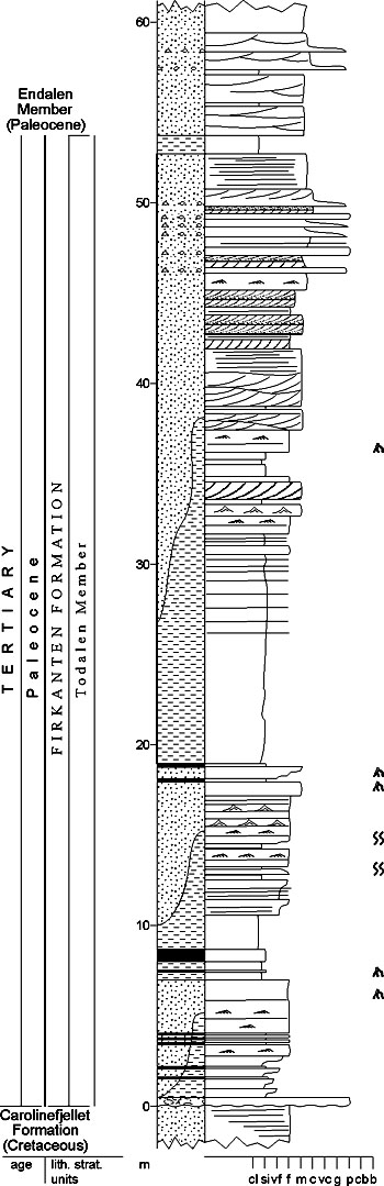
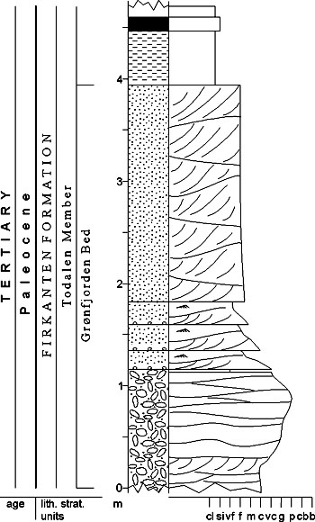
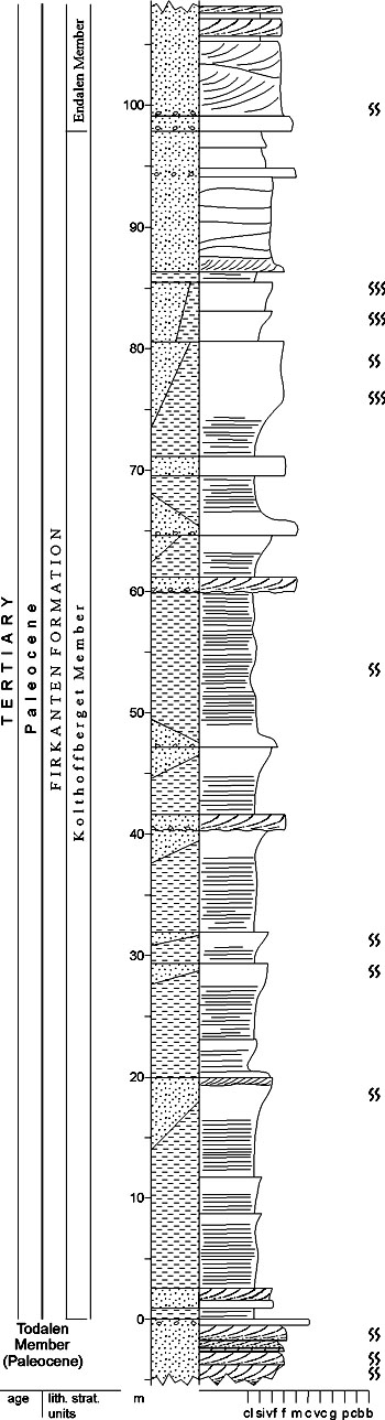
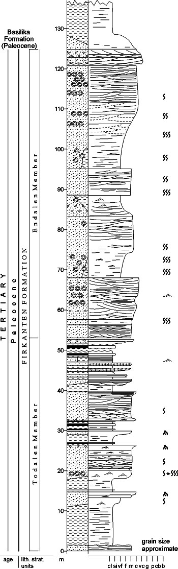
DISTRIBUTION shown in fig(s).: 4-04, 4-05 STATUS OF UNIT: Formal FIRST USE OF NAME: Major & Nagy 1964 CURRENT DEFINITION: Major & Nagy 1972 SYNONYM(S) AND REFERENCE(S): "Lower light sandstone series": Nathorst 1910; "Lower coal-bearing sandstone fm.": Ljutkevič 1937a; "Barentsburg Formation": Livšic 1967. The contemporaneously published name Firkanten Formation (Major & Nagy 1964, 1972) is preferred because of its more extensive use in the published literature on this unit (see Section 4.3.1). ORIGIN OF NAME: Firkanten (transl.: "The Rectangle"): A mountain in Nathorst Land, south-central Spitsbergen TYPE SECTION (figs. 4-14, 4-15, 4-17, 4-19): Stratotype: Karl Bayfjellet (composite section) DEPOSITIONAL AGE: Paleocene DATING METHOD: Bivalves; plant remains; palynology REFERENCE(S) FOR AGE: Ravn 1922; Livšic 1973, 1974; Manum & Throndsen 1986 (see Van Mijenfjorden Group) OVERLYING UNIT(S): Basilika Formation UNDERLYING UNIT(S): Carolinefjellet Formation SUPERIOR UNIT: Van Mijenfjorden Group OTHER USE OF NAME: None THICKNESS: 100-170 m, ca. 125 m in the stratotype MAIN LITHOLOGIES: Sandstone, shale, coal LOWER BOUNDARY DEFINITION: The base of the Firkanten Formation is marked by the low-angle unconformity above the Lower Cretaceous Carolinefjellet Formation. Where no basal conglomerate or palaeo-weathering surface is developed, the base may be difficult to recognise, although the basal sandstones are softer or more massive than the underlying Cretaceous platy and well-laminated sandstones. DESCRIPTION: The Firkanten Formation is 170 m thick in type area, thinning northeastwards to less than 100 m thick. A basal conglomerate often defines the base (fig. 4-11). The lower part of the formation is characteristically coalbearing (less marked in the south), with interbedded marine and non-marine sandstones, siltstones and shales. The upper part is sand-prone in the north and northeast, consisting of light, well-bioturbated or laminated marine sandstones interbedded with minor conglomerates, siltstones and clay ironstones. In western and southern regions the same interval contains southwesterly thickening wedges of shales and siltstones, especially in its lower and middle portions. The Firkanten Formation contains the most important productive coal deposits of Svalbard (Longyearbyen, Barentsburg and Sveagruva; fig. 4-12). The unit shows a systematic thickening and deepening of facies from the north and northeast to the south and west. The lower, coal-bearing part is deltaic in origin and represents a stacked series of units interpreted as deltaic lobes. The upper part is more thoroughly marine and apparently represents a series of barrier shoreline developments. The overall transgressive trend in the unit, with coastline retreat towards the east and northeast, is typical for the earliest infill of foreland basins. Todalen Member (T-03) STATUS OF UNIT: Formal FIRST USE OF NAME: Steel et al. 1981, after Kalgraff 1978 (unpubl.) CURRENT DEFINITION: Steel et al. 1981 SYNONYM(S) AND REFERENCE(S): None ORIGIN OF NAME: Todalen (transl. "The No. 2 Valley"): A tributary valley to Adventdalen, close to Longyearbyen TYPE SECTION (figs. 4-14, 4-15): Stratotype: Bayfjellnosa, Todalen N, close to Longyearbyen, Nordenskiöld Land. Hypostratotype: Røysklumpen, Kjellstrømdalen, Heer Land DEPOSITIONAL AGE: Paleocene DATING METHOD: Palynology REFERENCE(S) FOR AGE: Manum & Throndsen 1986 OVERLYING UNIT(S): Endalen and Kolthoffberget members UNDERLYING UNIT(S): Carolinefjellet Formation SUPERIOR UNIT: Firkanten Formation OTHER USE OF NAME: None THICKNESS: 53 m in the stratotype MAIN LITHOLOGIES: Sandstone, shale, coal LOWER BOUNDARY DEFINITION: See Firkanten Formation DESCRIPTION: The unit consists of some 3-5 rhythmic successions of shale-siltstone-sandstone-coal in the northeastern part of the Central Basin. Coals and shales can dominate north of Adventdalen, whereas bioturbated marine sandstones and shales are common south of Van Mijenfjorden. The base of the unit is defined either by basal conglomerates and conglomeratic sandstones (Grønfjorden conglomerate), or, where these are absent, the depositional contact with the underlying Cretaceous strata. The Todalen Member contains the most important productive coal deposits of Svalbard (Longyearbyen, Barentsburg and Sveagruva; figs. 4-08, 4-12, 4-13). The unit thickens and shows a slight deepening of depositional environment to the west. Rhythmic successions represent repeated progradation and retrogradation of deltaic systems which built out mainly from the northeast and east of the basin. A marked structural horst separated subbasins north and south of Van Mijenfjorden. Grønfjorden Bed (T-04) STATUS OF UNIT: Formal FIRST USE OF NAME: Here CURRENT DEFINITION: Here SYNONYM(S) AND REFERENCE(S): None ORIGIN OF NAME: Grønfjorden (transl. "The Green Fiord"): A fiord in northwestern Nordenskiöld Land TYPE SECTION (fig. 4-16): Stratotype: Grønfjorden NW, northwestern Nordenskiöld Land DEPOSITIONAL AGE: Paleocene DATING METHOD: Indirect, stratigraphic relationship REFERENCE(S) FOR AGE: See Firkanten Formation OVERLYING UNIT(S): Not named UNDERLYING UNIT(S): Carolinefjellet Formation SUPERIOR UNIT: Todalen Member OTHER USE OF NAME: None THICKNESS: 0-5 m, 4 m in the stratotype MAIN LITHOLOGIES: Conglomerate LOWER BOUNDARY DEFINITION: The base of the unit is defined by the development of conglomerate above platy Cretaceous sandstones. DESCRIPTION: The Grønfjorden Bed is only irregularly developed as a basal conglomerate interval across the basin, reaching a maximum of more than 4.5 m at the northwestern corner of Grønfjorden in the type area (fig. 4-11). The bed consists of clast-supported and matrix-supported conglomerates, conglomeratic sandstones and associated sandstones and has been recorded up to 2 m thick in the northeast (Bassen, Konussen) as well as along the western edge of the basin as far south as Van Mijenfjorden (Kolfjellet). The basal conglomerates and associated sandstones probably represent an incised valley within the underlying Cretaceous land surface, infilled by alluvial processes. Kolthoffberget Member (T-05) STATUS OF UNIT: Formal FIRST USE OF NAME: Steel et al. 1981, after Kalgraff 1978 (unpubl.) CURRENT DEFINITION: Steel et al. 1981 SYNONYM(S) AND REFERENCE(S): None ORIGIN OF NAME: Kolthoffberget: A mountain on the northern coast of Van Keulenfjorden, Nathorst Land TYPE SECTION (fig. 4-17): Stratotype: Kolthoffberget, Nathorst Land DEPOSITIONAL AGE: Late Paleocene DATING METHOD: Agglutinated foraminifera REFERENCE(S) FOR AGE: J. Nagy (pers. comm. 1998) OVERLYING UNIT(S): Endalen Member, Basilika Formation UNDERLYING UNIT(S): Todalen Member SUPERIOR UNIT: Firkanten Formation OTHER USE OF NAME: None THICKNESS: Up to 120 m, 98 m in the stratotype MAIN LITHOLOGIES: Shale, sandstone LOWER BOUNDARY DEFINITION: The lower boundary is defined by the base of a shale-dominated succession overlying the upper sandstones of the Todalen Member. DESCRIPTION: The unit is developed only in the western and southern parts of the basin and reaches a thickness of about 120 m on Kolthoffberget. It is a fine-grained lateral equivalent to the Endalen Member and consists of repeated rhythmic successions of shales. Organic rich, very fine sandstones also occur in the type area on Kolthoffberget. The sandstones are always extremely bioturbated and individual successions are less than 10 m thick. Where present, the unit overlies the coal-bearing Todalen Member and underlies the youngest sandstone tongues of the Endalen Member (if present) or interfingers with the Basilika Formation. The member represents repeated shoaling-upward conditions on the pro-deltaic or shelf areas of the Central Cenozoic Basin. Endalen Member (T-06) STATUS OF UNIT: Formal FIRST USE OF NAME: Steel et al. 1981, after Kalgraff 1978 (unpubl.) CURRENT DEFINITION: Steel et al. 1981 SYNONYM(S) AND REFERENCE(S): None ORIGIN OF NAME: Endalen (transl. "The No. 1 Valley"): A tributary valley of Adventdalen, close to Longyearbyen TYPE SECTION (fig. 4-19): Stratotype: Bayfjellnosa, Todalen N, close to Longyearbyen, Nordenskiöld Land DEPOSITIONAL AGE: Paleocene DATING METHOD: Indirect, stratigraphic relationship REFERENCE(S) FOR AGE: See Firkanten Formation OVERLYING UNIT(S): Basilika Formation UNDERLYING UNIT(S): Todalen or Kolthoffberget members SUPERIOR UNIT: Firkanten Formation OTHER USE OF NAME: None THICKNESS: 40-100 m, 72 m in the stratotype MAIN LITHOLOGIES: Sandstone LOWER BOUNDARY DEFINITION: The base of the member is marked by the first thick, medium-grained, cliff-forming sandstone above the coals and shales of the underlying Todalen r Kolthoffberget members. DESCRIPTION: The Endalen Member is some 70 m thick in its type area, but otherwise varies from 40 m (northeast) to 100 m (south and southwest). It consists of a stacked series of 4-5 sandstone intervals which often show an upwardcoarsening trend in the northeastern part of the area. The sandstones form prominent cliffs (figs. 4-12, 4-18) and are well bioturbated or cross-stratified, with interbedded thin conglomerates, clay ironstones and minor shales. In the west of the basin and south of Van Mijenfjorden the unit becomes thicker and interfingers with the shale-prone Kolthoffberget Member. The Endalen Member thickens considerably and shows a deepening of facies to the west and south in the basin. Component sandstone intervals represent transgression and regression of a deltaic or barrier shoreline which built out repeatedly from the northeast. Back to top BASILIKA FORMATION (T-07) 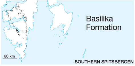
DISTRIBUTION shown in fig(s).: 4-04, 4-05 STATUS OF UNIT: Formal FIRST USE OF NAME: Major & Nagy 1964 CURRENT DEFINITION: Major & Nagy 1972 SYNONYM(S) AND REFERENCE(S): "Lower black shale series": Nathorst 1910; "Lower black shale formation": Ljutkevič 1937a; "Colesbukta Formation": Livšic 1967. The contemporaneously published name Basilika Formation (Major & Nagy 1964, 1972) is preferred because of its more extensive use in the published literature; it is also more completely exposed at the mountain Basilika (see Section 4.3.1). ORIGIN OF NAME: Basilika (transl.: "Basilica"): A mountain in northeastern Wedel Jarlsberg Land, Van Keulenfjorden, south-central Spitsbergen TYPE SECTION (fig. 4-20): Stratotype: Akselvarden, Nordenskiöld Land DEPOSITIONAL AGE: Late Paleocene DATING METHOD: Palynology, agglutin. foraminifera REFERENCE(S) FOR AGE: Manum & Throndsen 1986; J. Nagy (pers. comm. 1998) OVERLYING UNIT(S): Grumantbyen Formation UNDERLYING UNIT(S): Firkanten Formation SUPERIOR UNIT: Van Mijenfjorden Group OTHER USE OF NAME: None THICKNESS: 10-350 m, 270 m in the stratotype MAIN LITHOLOGIES: Shale, mudstone, siltstone LOWER BOUNDARY DEFINITION: The base of the unit is well defined by thick shales which overlie the uppermost sandstone beds of the Endalen Member. DESCRIPTION: The Basilika Formation thickens from about 10 m in the northeastern region to more than 300 m in western Nordenskiöld Land and more than 350 m in western Torell Land. It consists primarily of shales, mudstones and siltstones, usually organised in repeated, thin upward-coarsening successions. Rounded dropstones of metamorphic basement and dolerite lithologies are common, as well as bentonitic interbeds. The unit represents muddy shelf conditions, with repeated influx of silty sediments from the east and northeast, the latter caused by repeated shoaling in the northeasterly reaches of the basin. Back to top GRUMANTBYEN FORMATION (T-08) 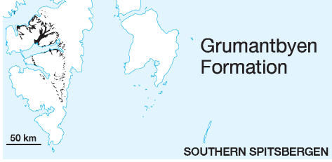
DISTRIBUTION shown in fig(s).: 4-04, 4-05 STATUS OF UNIT: Formal FIRST USE OF NAME: Livšic 1967 CURRENT DEFINITION: Steel et al. 1981 SYNONYM(S) AND REFERENCE(S): "Green sandstone formation": Ljutkevič 1937a; "Grumant Formation": Livšic 1967. The place segment of the name was first completed by Steel et al. 1981. The Grumantbyen Formation is equivalent to the lower part of both the "Green sandstone series" (Nathorst 1910) and of the "Sarkofagen Formation" (Major & Nagy 1964, 1972). ORIGIN OF NAME: Grumantbyen: An abandoned Soviet coal mine on the coast of Isfjorden, Nordenskiöld Land, central Spitsbergen TYPE SECTION: Stratotype: Grumantbyen, Nordenskiöld Land DEPOSITIONAL AGE: ?Paleocene - ?Eocene DATING METHOD: Indirect, stratigraphic relationship REFERENCE(S) FOR AGE: Livšic 1973, 1974; Manum & Throndsen 1986 (see Van Mijenfjorden Group) OVERLYING UNIT(S): Frysjaodden Formation UNDERLYING UNIT(S): Basilika Formation SUPERIOR UNIT: Van Mijenfjorden Group OTHER USE OF NAME: None THICKNESS: 0-450 m MAIN LITHOLOGIES: Sandstone LOWER BOUNDARY DEFINITION: The base of the unit is gradational from the shales and siltstones of the Basilika Formation, but is defined by the incoming of greenish, bioturbated, silty sandstones. DESCRIPTION: The unit is some 450 m thick in the northeast and east of the Central Cenozoic Basin, but thins to less than 200 m to the west and southwest. Relations in the southernmost reaches of the basin are not quite clear yet, but the formation possibly pinches out completely to the south to be replaced by an upward coarsening trend in the underlying siltstones of the Basilika Formation. The Grumantbyen Formation consists of a greenish, massive and highly bioturbated sandstone. The upper part of the unit becomes finer grained, with a rhythmic development of siltstone to silty sandstone motifs. Back to top FRYSJAODDEN FORMATION (T-09) 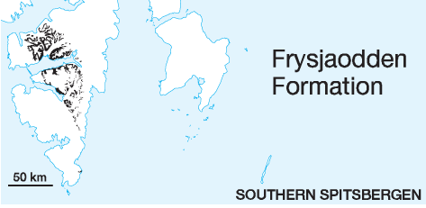
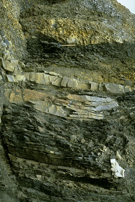
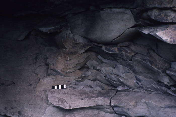
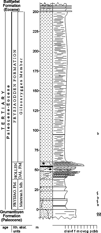
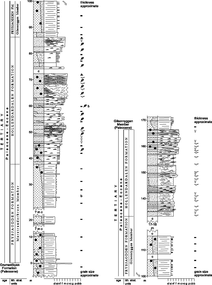
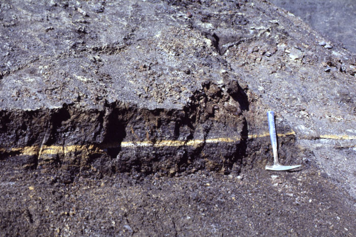
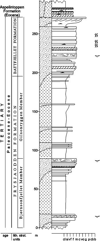
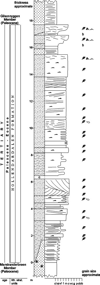
DISTRIBUTION shown in fig(s).: 4-04, 4-05 STATUS OF UNIT: Formal FIRST USE OF NAME: Livšic 1967 CURRENT DEFINITION: Here. The present redefinition changes the original base of the formation, but only in western areas of the Central Cenozoic Basin, to include the shaley Marstranderbreen Member. The latter is included because of its lateral correlation with the southern and eastern exposures of the Frysjaodden Formation which remain unchanged from its original definition. SYNONYM(S) AND REFERENCE(S): "Upper black shale series": Nathorst 1910; "Upper black shale formation": Ljutkevič 1937a; "Upper argillite formation": Livšic 1965; "Gilsonryggen Formation": Major & Nagy 1964, 1972. These names are equivalents of the original definition of the Frysjaodden Formation, i.e. without the Marstranderbreen Member. ORIGIN OF NAME: Frysjaodden: A cape on the southern coast of Van Mijenfjorden. TYPE SECTION (fig. 4-21): Stratotype: Lindströmfjellet-Nordenskiöldfjellet, Nordenskiöld Land DEPOSITIONAL AGE: ?Paleocene - ?Eocene DATING METHOD: Bivalves; palynology REFERENCE(S) FOR AGE: Ravn 1922; Livšic 1973, 1974; Manum & Throndsen 1986 (see Van Mijenfjorden Group) OVERLYING UNIT(S): Battfjellet Formation UNDERLYING UNIT(S): Grumantbyen Formation INTERCALATED UNIT(S): Hollendardalen Formation SUPERIOR UNIT: Van Mijenfjorden Group OTHER USE OF NAME: None THICKNESS: 200-400 m, 250 m in the stratotype MAIN LITHOLOGIES: Shale, sandstone LOWER BOUNDARY DEFINITION: The basal part of the formation consists of shale with thin and irregularly shaped conglomerate lenses. The shales rest sharply on the siltstones and silty sandstones of the Grumantbyen Formation. DESCRIPTION: The unit is about 200 m thick in the northern and northeastern parts of the Central Cenozoic Basin, but thickens to more than 400 m south- and southwestwards. These thickness values include the up to 150 m thick intercalated sandstone lobes of the Hollendardalen Formation. The Frysjaodden Formation is essentially shale-prone, but is interbedded with a major laminated sandstone wedge (Hollendardalen Formation) near its base and several thinner sandstone wedges (Bjørnsonfjellet Member) in its middle part. Together with the sandstone lobes of the Hollendardalen Formation, the Frysjaodden Formation represents a major change in drainage direction and pattern compared to the earlier history of the basin. The unit is thought to be contemporaneous with major uplift and overthrusting of the West Spitsbergen Fold-thrust Belt, and shows clear evidence of sediment input from west and of eastwards migration of the basin depocentre. Marstranderbreen Member (T-10) STATUS OF UNIT: Formal FIRST USE OF NAME: Here CURRENT DEFINITION: Here SYNONYM(S) AND REFERENCE(S): None ORIGIN OF NAME: Marstranderbreen: A glacier in western Nordenskiöld Land TYPE SECTION (figs. 4-21, 4-22): Stratotype: Marstranderbreen, Nordenskiöld Land. Hypostratotype: Lindströmfjellet - Nordenskiöldfjellet DEPOSITIONAL AGE: ?Paleocene - ?Eocene DATING METHOD: Indirect, stratigraphic relationship REFERENCE(S) FOR AGE: See Frysjaodden Formation OVERLYING UNIT(S): Hollendardalen Formation UNDERLYING UNIT(S): Grumantbyen Formation SUPERIOR UNIT: Frysjaodden Formation OTHER USE OF NAME: None THICKNESS: 10-60 m, 38 m in the stratotype MAIN LITHOLOGIES: Shale LOWER BOUNDARY DEFINITION: See Frysjaodden Formation DESCRIPTION: The unit consists of dark shales with occasional siltstone layers. It interfingers laterally with the sandstones of the Hollendardalen Formation. The Marstranderbreen Member represents the deeper water deposits of the foreland basin adjacent to the growing West Spitsbergen Fold-thrust Belt. Gilsonryggen Member (T-11) STATUS OF UNIT: Formal FIRST USE OF NAME: Major & Nagy 1964, 1972 CURRENT DEFINITION: Here SYNONYM(S) AND REFERENCE(S): Gilsonryggen "Formation": Major & Nagy 1964, 1972 ORIGIN OF NAME: Gilsonryggen: A mountain south of Adventdalen, Nordenskiöld Land TYPE SECTION (fig. 4-21): Stratotype: Nordenskiöldfjellet, Nordenskiöld Land DEPOSITIONAL AGE: ?Paleocene - Eocene DATING METHOD: Plant remains, foraminifera; palynology REFERENCE(S) FOR AGE: Livšic 1973, 1974; Manum & Throndsen 1986 (see Van Mijenfjorden Group) OVERLYING UNIT(S): Battfjellet Formation UNDERLYING UNIT(S): Hollendardalen Formation SUPERIOR UNIT: Frysjaodden Formation OTHER USE OF NAME: None THICKNESS: 190 (stratotype) - 250 m MAIN LITHOLOGIES: Shale LOWER BOUNDARY DEFINITION: The base of the Gilsonryggen Member is defined where shales and siltstone become dominating above the sandstones of the Hollendardalen Formation. DESCRIPTION: The Gilsonryggen Member consists of black shales with occasional siltstone layers and bentonites (fig. 4-24). It varies in thickness from about 200 m in the north and northeast of the Central Cenozoic Basin to more than 250 m in the south and southwest. The unit interfingers laterally northwestwards with the sandstones of the Bjørnsonfjellet Member. The base of the unit is gradational from the sandstones of the Hollendardalen Formation, the top is also gradational to the sandstones of the Battfjellet Formation (fig. 4-23). The member is only defined where the Hollendardalen Formation occurs as an underlying development. It is a time and facies equivalent of the upper, undivided parts of the Frysjaodden Formation developed farther east. The shales of the Gilsonryggen Member represent the deeper water deposits of the foreland basin adjacent to the growing West Spitsbergen Fold-thrust Belt. Bjørnsonfjellet Member (T-12) STATUS OF UNIT: Formal FIRST USE OF NAME: Steel et al. 1981 CURRENT DEFINITION: Here SYNONYM(S) AND REFERENCE(S): None ORIGIN OF NAME: Bjørnsonfjellet: A mountain in western Nordenskiöld Land TYPE SECTION (fig. 4-25): Stratotype: Bjørnsonfjellet, Nordenskiöld Land DEPOSITIONAL AGE: ?Paleocene - Eocene DATING METHOD: Indirect, stratigraphic relationship REFERENCE(S) FOR AGE: See Frysjaodden Formation OVERLYING UNIT(S): Gilsonryggen Member UNDERLYING UNIT(S): Gilsonryggen Member SUPERIOR UNIT: Frysjaodden Formation OTHER USE OF NAME: None THICKNESS: <100 m, 90 m in the stratotype MAIN LITHOLOGIES: Sandstone, shale LOWER BOUNDARY DEFINITION: The base of the Bjørnsonfjellet Member is transitional and defined at the first thick (several metres) sandstone wedge in middle levels of the Gilsonryggen Member. DESCRIPTION: The Bjørnsonfjellet Member consists of several thin sandstone wedges, each up to 15-20 m thick, in the western areas of the basin, both north and south of Van Mijenfjorden. They thin out in the centre of the basin, passing into Gilsonryggen Member shales. The sandstone units consist of beds which are massive, normally graded or softsediment deformed, and have fluted or grooved soles. The unit occurs in the middle or just below the middle levels of the shales of the Gilsonryggen Member. As with the Hollendardalen Formation on a larger scale, the Bjørnsonfjellet Member represents clastic input to the basin from the west, as a result of uplift and growth of the West Spitsbergen Fold-Thrust Belt. The Bjørnsonfjellet Member represents high density turbidite and slump deposits in the foreland basin. Back to top HOLLENDARDALEN FORMATION (T-13) 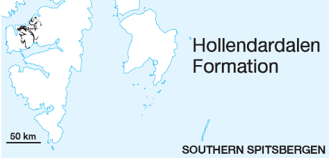
DISTRIBUTION shown in fig.: 4-05 STATUS OF UNIT: Formal FIRST USE OF NAME: Livšic 1967 CURRENT DEFINITION: Here. Although the base of the formation is redefined to exclude the very thin shales of the Marstranderbreen Member, the basic idea that the Hollendardalen Formation essentially dessignates a thick sandstone succession below the main shale body of the Frysjaodden Formation, is kept. The formation name from Livšic (1967) is therefore not changed. SYNONYM(S) AND REFERENCE(S): "Shaley green sandstone formation": Ljutkevič 1937a; "Lower transitional formation": Livšic 1965. These names are equivalents of the Hollendardalen Formation as originally defined, i.e. including the Marstranderbreen Member. This unit also equals the upper part of the "Green sandstone series" (Nathorst 1910) and the "Sarkofagen Formation" (Major & Nagy 1964, 1972). ORIGIN OF NAME: Hollendardalen (transl.: "The Valley of the Dutch"): A valley in western Nordenskiöld Land TYPE SECTION (figs. 4-22, 4-26): Stratotype: Marstranderbreen, western Nordenskiöld Land (development with two sandstone lobes). Hypostratotype: Bødalen, central Nordenskiöld Land (development with one sandstone lobe) DEPOSITIONAL AGE: ?Paleocene - ?Eocene DATING METHOD: Indirect, stratigraphic relationship REFERENCE(S) FOR AGE: Livšic 1973, 1974; Manum & Throndsen 1986 (see Van Mijenfjorden Group) OVERLYING UNIT(S): Gilsonryggen Member (Frysjaodden Formation) UNDERLYING UNIT(S): Marstranderbreen Member (Frysjaodden Formation) SUPERIOR UNIT: Van Mijenfjorden Group OTHER USE OF NAME: None THICKNESS: <150 m, 82 m (cumulative) in the stratotype, 18 m in the hypostratotype MAIN LITHOLOGIES: Sandstone LOWER BOUNDARY DEFINITION: The formation boundary occurs within a coarsening-upward succession and is defined, where sandstone beds begin to form a distinct element. The sandstones of the Hollendardalen Formation rest with a fairly sharp contact on the shales of the Marstranderbreen Member. DESCRIPTION: The Hollendardalen Formation consists of several wedges of well-laminated sandstone which collectively reach a thickness of up to 150 m in the western parts of the basin. They thin out eastwards to the basin centre, where they are replaced by the shales of the Frysjaodden Formation. Typical features of the sandstones are plant fragments, rootlets and ripple lamination. The Hollendardalen Formation represents initial coarser clastic input from the uplifting West Spitsbergen Fold-Thrust Belt. The sandstones are shallow marine deposits originating on tidally-influenced deltas. Back to top BATTFJELLET FORMATION (T-14) 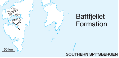
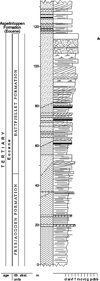
DISTRIBUTION shown in fig(s).: 4-04, 4-05 STATUS OF UNIT: Formal FIRST USE OF NAME: Major & Nagy 1964 CURRENT DEFINITION: Major & Nagy 1972 SYNONYM(S) AND REFERENCE(S): "Fissile sandstone series": Nathorst 1910; "Upper shaley sandstone formation": Ljutkevič 1937a; "Flaggy sandstone series": Orvin 1940; "Collinderodden Formation": Livšic 1967. The contemporaneously published name Battfjellet Formation (Major & Nagy 1964, 1972) is preferred because of its more extensive use in the published literature (see Section 4.3.1). ORIGIN OF NAME: Battfjellet: A mountain in central Nordenskiöld Land TYPE SECTION (fig. 4-27): Stratotype: Battfjellet SW, central Nordenskiöld Land DEPOSITIONAL AGE: ?Paleocene - Eocene DATING METHOD: Bivalves; indirect REFERENCE(S) FOR AGE: Ravn 1922; Livšic 1973, 1974; Manum & Throndsen 1986 (see Van Mijenfjorden Group) OVERLYING UNIT(S): Aspelintoppen Formation UNDERLYING UNIT(S): Frysjaodden Formation SUPERIOR UNIT: Van Mijenfjorden Group OTHER USE OF NAME: None THICKNESS: >300 m, 71 m in the stratotype MAIN LITHOLOGIES: Sandstone, siltstone, shale LOWER BOUNDARY DEFINITION: The formation boundary occurs within a coarsening-upward succession. The base of the Battfjellet Formation is defined by the first occurrence of thick sandstone beds above the dark shales of the Frysjaodden Formation (fig. 4-23). DESCRIPTION: The Battfjellet Formation varies in thickness from less than 60 m in the northeast of the basin (type area) to more than 300 m south of Van Mijenfjorden. It consists of well-laminated and cross-stratified, cliff-forming, whitish sandstones interbedded with minor shales and siltstones. The formation has a gradational contact with the underlying shales of the Gilsonryggen Member. The formation represents a late stage of coastal progradation and infill of the fold-belt-flanked foreland basin, when sediment input finally outpaced subsidence and the basin was filled to sea level. Back to top ASPELINTOPPEN FORMATION (T-15) 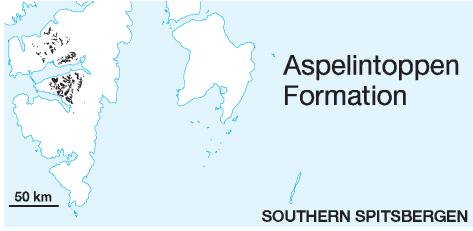
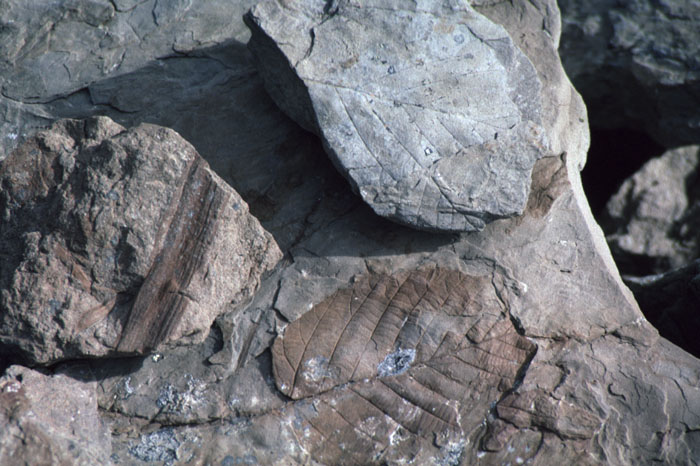
DISTRIBUTION shown in fig(s).: 4-04, 4-05 STATUS OF UNIT: Formal FIRST USE OF NAME: Major & Nagy 1964 CURRENT DEFINITION: Major & Nagy 1972 SYNONYM(S) AND REFERENCE(S): "Upper coal-bearing series": Nathorst 1910; "Upper coal-bearing sandstone fm.": Ljutkevič 1937a; "Upper plant-bearing sandstone series": Orvin 1940; "Storvola Formation": Livšic 1967. The contemporaneously published name Aspelintoppen Formation (Major & Nagy 1964, 1972) is preferred because of its more extensive use in the published literature (see Section 4.3.1). ORIGIN OF NAME: Aspelintoppen: A mountain in Nathorst Land on the southern coast of Van Mijenfjorden, east of the type section TYPE SECTION (fig. 4-29): Stratotype: Rånekampen, Nathorst Land DEPOSITIONAL AGE: ?Eocene - ?Oligocene DATING METHOD: Plant remains; palynology REFERENCE(S) FOR AGE: Livšic 1973, 1974; Manum & Throndsen 1986 (see Van Mijenfjorden Group) OVERLYING UNIT(S): None UNDERLYING UNIT(S): Battfjellet Formation SUPERIOR UNIT: Van Mijenfjorden Group OTHER USE OF NAME: None THICKNESS: >1000 m MAIN LITHOLOGIES: Sandstone, siltstone, mudstone LOWER BOUNDARY DEFINITION: The base of the Aspelintoppen Formation is defined at the base of the first coals or thicker shaley intervals above the thick, sand-prone intervals at the top of Battfjellet Formation. DESCRIPTION: The Aspelintoppen Formation reaches a thickness of more than 1000 m south of Van Mijenfjorden. It consists of alternations of sandstones with siltstones, mudstones and thin coals. Sandstone intervals, which are cross-stratified and commonly soft-sediment deformed, are rarely thicker than 3-5 metres. The formation contains abundant plant remains. Especially abundant and well preserved are leaves of trees (fig. 4-28). The formation represents the culmination in growth of the foreland basin, with its final infill of deposits with distinct terrestrial influence. Sediments represent various shallowwater deposits like distributary channels, crevasse splays and swamp deposits. Back to top NY-ÅLESUND SUBGROUP (T-16) 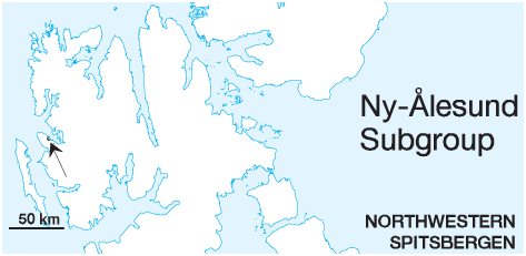
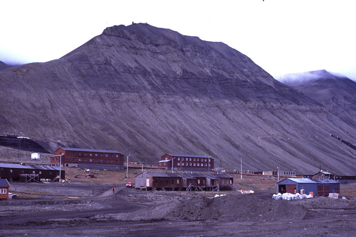
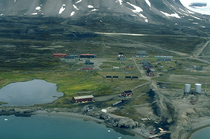
STATUS OF UNIT: Formal FIRST USE OF NAME: Challinor 1967 CURRENT DEFINITION: Challinor 1967 SYNONYM(S) AND REFERENCE(S): Ny-Ålesund "Formation": Challinor 1967 ORIGIN OF NAME: Ny-Ålesund: A former coal mining settlement on Brøggerhalvøya, now a research centre (fig. 4-30), named after Ålesund, a town in western mainland Norway TYPE AREA / TYPE SECTIONS: Ny Ålesund coal mining area ("Kongsfjordfeltet"), Brøggerhalvøya. The stratigraphy of the area is only sufficiently known from borehole data, and type sections are mostly confined to boreholes. STRUCTURAL SETTING: Occurs in the West Spitsbergen Fold-thrust belt. Deposits are most probably related to the succession of the Central Cenozoic Basin. DEPOSITIONAL AGE: Paleocene (or ?Oligocene). Earlier interpretations of Miocene age of the entire Cenozoic of Spitsbergen (Heer 1868, 1870) have been questioned since 1922 (Ravn) and are outruled by modern palynology (Manum & Throndsen 1986). Most authors favour a Paleocene age of the subgroup based on lithostratigraphic correlations and comparative studies of plant remains. Livšics (1973, 1974) age interpretation (Oligocene) is considerably younger. According to Manum & Throndsen (1986) the flora is not conclusive, hence the age preferred by the various authors depends on the lithostratigraphic correlations preferred by them. OVERLYING UNIT(S): None UNDERLYING UNIT(S): Vardebukta Formation (Sassendalen Group) or Kapp Starostin Formation (Tempelfjorden Group) SUPERIOR UNIT: Van Mijenfjorden Group OTHER USE OF NAME: "Ny-Ålesund Formation" (Livšic 1973) for the upper formation of the subgroup (see Brøggerbreen Formation); Ny-Ålesund coal field (Livšic 1973) for the coal mining area developed in this unit THICKNESS: ca. 270 m preserved MAIN LITHOLOGIES: Sandstone, shale, coal DESCRIPTION: The Ny-Ålesund Subgroup comprises all Cenozoic deposits present in the Kongsfjorden (Ny-Ålesund) area which are preserved in minor fault blocks of altogether 6 x 3 km lateral extension. It overlies Triassic and Permian deposits with a low-angle unconformity and is overlain by Carboniferous and Permian strata thrust over along a highangle reverse fault. It consists of the clastic, coal-bearing Kongsfjorden and Brøggerbreen formations (see these formational descriptions). The Ny-Ålesund unit has been raised to subgroup rank, because unpublished work (mainly Midbøe 1985) has shown that the definition of the two formations is most appropriate with regard to comparison to the Central Cenozoic Basin succession of the Van Mijenfjorden Group. KONGSFJORDEN FORMATION (T-17) 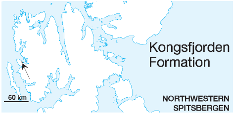
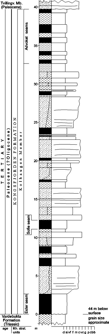
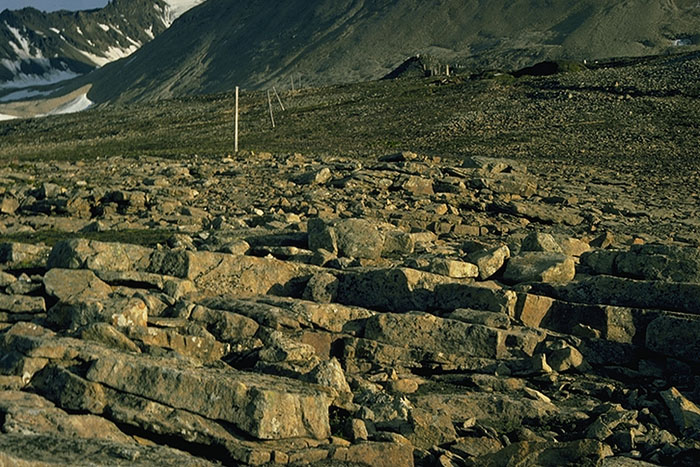
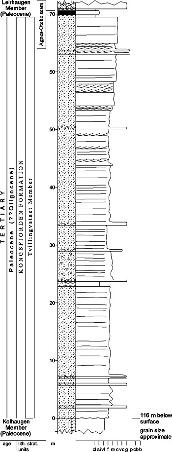
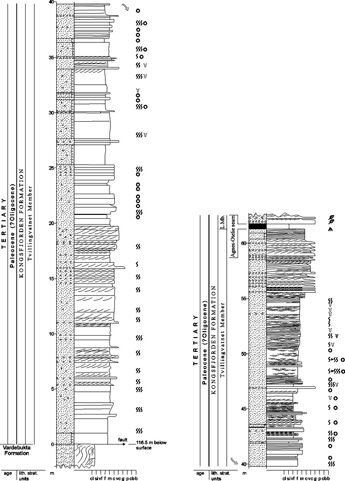
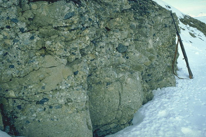
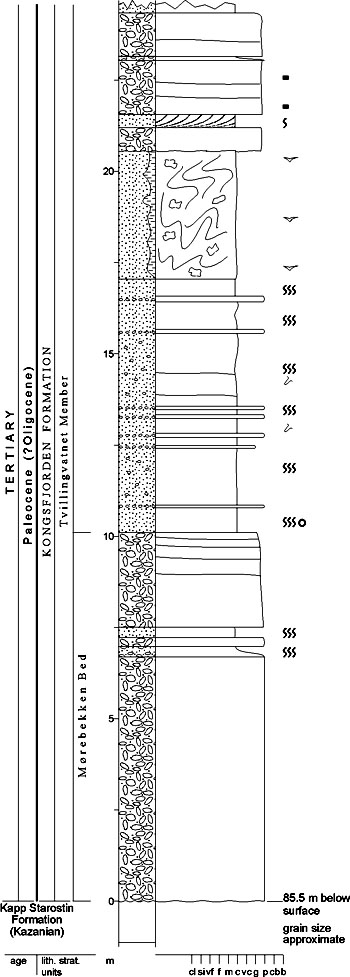
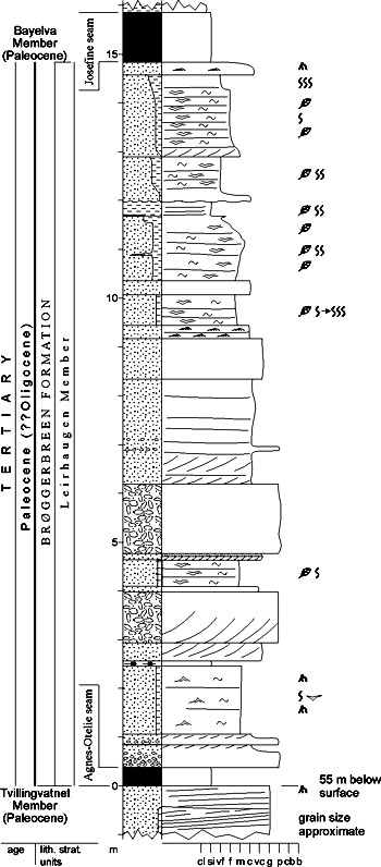
DISTRIBUTION shown in fig. 4-06 STATUS OF UNIT: Formal FIRST USE OF NAME: Livšic 1973 CURRENT DEFINITION: Livšic 1973 SYNONYM(S) AND REFERENCE(S): "Grey sandstone": Orvin 1934; "Grey Sandstone Member": Challinor 1967. ORIGIN OF NAME: Kongsfjorden (transl. from "King's Bay"): A fiord in northeastern Spitsbergen TYPE SECTION (figs. 4-32, 4-34, 4-35): Stratotype: Boreholes 4-1928 and 5-1928 (composite) DEPOSITIONAL AGE: Paleocene (*alternatively Oligocene; see Ny-Ålesund Subgroup) DATING METHOD: Plant fossils; lithostratigraphic correlation REFERENCE(S) FOR AGE: Orvin 1934; Schloemer-Jäger 1958; Schweitzer 1974; *Livšic 1973, 1974; Midbøe 1985 (unpubl.) OVERLYING UNIT(S): Brøggerbreen Formation UNDERLYING UNIT(S): Vardebukta Formation (Sassendalen Group) or Kapp Starostin Formation (Tempelfjorden Group) SUPERIOR UNIT: Ny-Ålesund Subgroup OTHER USE OF NAME: Kongsfjordfeltet (Norwegian for Kongsfjorden Field = Kings Bay coal mining field) is used for the coal mining area related to this and the overlying formation The place name is also used based on another fiord with the same name in Finnmark, mainland Norway (Kongsfjord[en] Formation: Siedlecka 1972b; Kongsfjorden Anticline: Roberts 1972; Kongsfjordgangkomplekset: registered by NSK). THICKNESS: 110 m (cumulative) in the stratotypes MAIN LITHOLOGIES: Sandstone, shale, coal LOWER BOUNDARY DEFINITION: The lower boundary is marked by the first appearance of Cenozoic sediments (clastic rocks or coal) on the angular unconformity above Triassic and Permian folded sediments. The Cenozoic succession starts normally with the Ester coal seam. DESCRIPTION: The Kongsfjorden Formation consists of clastic sediments (sandstones, shales and conglomerates) with coal seams representing alluvial to foreshore depositional environments. For more detailed descriptions see its subunits: the Kolhaugen and Tvillingvatnet members. Kolhaugen Member (T-18) STATUS OF UNIT: Formal FIRST USE OF NAME: Here CURRENT DEFINITION: Here, following Midbøe 1985 (unpubl.) SYNONYM(S) AND REFERENCE(S): "Lower coal horizon": Orvin 1934 ORIGIN OF NAME: Kolhaugen (transl.: "The Coal Hill"): A hill SW of the settlement Ny-Ålesund TYPE SECTION (fig. 4-32): Stratotype: Borehole 5-1928. Hypostratotype (preliminary): Borehole 25-1976. Borehole 5-1928 represents the most complete section through the Kolhaugen Member. The cores from this borehole do not exist any more, but the lower part of the member was penetrated in borehole 25-1976 (preliminary hypostratotype). A log of the stratotype (fig. 4-32) has been reconstructed by Midbøe (1985, unpubl.) from the detailed core descriptions of Orvin (1934). DEPOSITIONAL AGE: Paleocene (alternatively Oligocene; see Ny-Ålesund Subgroup) DATING METHOD: Plant fossils and lithostratigraphic correlation REFERENCE(S) FOR AGE: See Ny-Ålesund Subgroup OVERLYING UNIT(S): Tvillingvatnet Member UNDERLYING UNIT(S): Vardebukta Formation (Sassendalen Group) SUPERIOR UNIT: Kongsfjorden Formation OTHER USE OF NAME: None THICKNESS: <45 m, 40 m in the stratotype MAIN LITHOLOGIES: Sandstone, shale, coal LOWER BOUNDARY DEFINITION: See Kongsfjorden Formation DESCRIPTION: The Kolhaugen Member consists of rapidly alternating fine-grained sandstones, shales, coaly shales and coal with several well-developed coal seams, named (from below) the Ester, Sofie and Advokaten seams. The unit rests with a slightly angular unconformity on the lower Triassic Vardebukta Formation in the east; it thins towards the west and is missing in the westernmost parts of the Kongsfjorden area. The member is interpreted to represent alluvial plain deposits. Tvillingvatnet Member (T-19) STATUS OF UNIT: Formal FIRST USE OF NAME: Here CURRENT DEFINITION: Here, following Midbøe 1985 (unpubl.) SYNONYM(S) AND REFERENCE(S): "Light sandstone": Orvin 1934; "Tvillingvann Member": Midbøe 1985 (unpubl.). The name is here changed according to the correct modern spelling of the place name. ORIGIN OF NAME: Tvillingvatnet (transl.: "The Twin Lake"): A small lake SW of the settlement Ny-Ålesund TYPE SECTION (figs. 4-34, 4-35): Stratotype: Borehole 4-1928. Hypostratotype: Borehole 21-1976. 2. Hypostratotype: Scheteligfjellet Borehole 4-1928 is the most complete section through the Tvillingvatnet Member (70 meter). The cores from this borehole do not exist any more and the log has been drawn from Orvin's (1934) descriptions. DEPOSITIONAL AGE: Paleocene (alternatively Oligocene; see Ny-Ålesund Subgroup) DATING METHOD: Plant fossils and lithostratigraphic correlation REFERENCE(S) FOR AGE: See Ny-Ålesund Subgroup OVERLYING UNIT(S): Brøggerbreen Formation UNDERLYING UNIT(S): Kolhaugen Member, Vardebukta Formation, locally Kapp Starostin Formation (Tempelfjorden Group) SUPERIOR UNIT: Kongsfjorden Formation OTHER USE OF NAME: None THICKNESS: 15-70 m, 70 m in the stratotype MAIN LITHOLOGIES: Sandstone, conglomerate LOWER BOUNDARY DEFINITION: The base of the member is defined by marine sandstone and conglomerate which overlie the eroded continental deposits of the Kolhaugen Member or older formations (Vardebukta Formation, Kapp Starostin Formation). The contact is an angular unconformity. DESCRIPTION: The Tvillingvatnet Member consists mainly of coarse- and medium-grained sandstones, pebbly sandstones and conglomerates, unconformably resting on older units. Most of the marine sandstones of the Tvillingvatnet Member were deposited below normal wave base and are intensively bioturbated. Well-preserved primary structures are only seen in the upper regressive part of the unit, where upper shoreface and foreshore deposits are directly overlain by the Agnes-Otelie coal seam of the Brøggerbreeen Formation (fig. 4-33). Where the member directly overlies the Permian Kapp Starostin Formation, a thick, local conglomerate is developed (see Mørebekken Bed). The current interpretation of the unit as a shallow marine sandstone succession is based on data from boreholes 21-1976 and 25-1976 which penetrate the upper and lower part of the unit, respectively. A thin (16.5 m) development of the unit is found in borehole 38-1976 in the northwestern part of the Kongsfjorden area. The mountain top of Scheteligfjellet shows the lower 60 m of the Tvillingvatnet Member, 20 m of which belong to the Mørebekken Bed. Mørebekken Bed (T-20) STATUS OF UNIT: Formal FIRST USE OF NAME: Here CURRENT DEFINITION: Here, following Midbøe 1985 (unpubl.) SYNONYM(S) AND REFERENCE(S): None ORIGIN OF NAME: Mørebekken (after the Norwegian area Møre, where also the town Ålesund is situated): A creek joining the river Bayelva NW of the settlement Ny-Ålesund TYPE SECTION (fig. 4-37): Stratotype: Borehole 38-1976. Hypostratotype: Scheteligfjellet DEPOSITIONAL AGE: Paleocene (alternatively Oligocene; see Ny-Ålesund Subgroup) DATING METHOD: Indirect, stratigraphic relationship REFERENCE(S) FOR AGE: See Ny-Ålesund Subgroup OVERLYING UNIT(S): Unnamed UNDERLYING UNIT(S): Kolhaugen Member, Kapp Starostin Formation (Tempelfjorden Group) SUPERIOR UNIT: Tvillingvatnet Member OTHER USE OF NAME: None THICKNESS: <20 m, possibly locally thicker, 10 m in the stratotype MAIN LITHOLOGIES: Conglomerate, sandstone LOWER BOUNDARY DEFINITION: The base of the unit is defined by the appearance of conglomerates erosively overlying the glauconitic sandstones and cherts of the Permian Kapp Starostin Formation. DESCRIPTION: Known thicknesses of the Mørebekken Bed are 10 m in borehole 38-1976 and 20 m on Scheteligfjellet. The unit consists mainly of coarse conglomerates with thin beds of coarse-grained sandstone. It is only locally represented in "Lagunefeltet" (a northwestern subarea of the coal mining area) and on Scheteligfjellet. The upper part of the bed is exposed along Mørebekken in "Lagunefeltet". The conglomerate is moderate to poorly sorted with wellrounded pebbles of chert and glauconitic sandstone and is interpreted to have been deposited in a marine beach to shoreface environment (fig. 4-36). Back to top BRØGGERBREEN FORMATION (T-21) 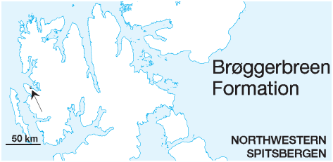
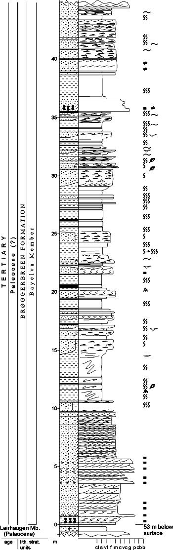
DISTRIBUTION shown in fig. 4-06 STATUS OF UNIT: Formal FIRST USE OF NAME: Here CURRENT DEFINITION: Livšic 1973 SYNONYM(S) AND REFERENCE(S): "Green sandstone": Orvin 1934; "Green Sandstone Member": Challinor 1967; "NyÅlesund Formation": Livšic 1967. ORIGIN OF NAME: Brøggerbreen: A glacier system (Austre and Vestre Brøggerbreen) with tongues ending into the outcrop area of the formation, Brøggerhalvøya TYPE SECTION (figs. 4-38, 4-39): Stratotype: Boreholes 21-1976, 24-1976 and 38-1976 (composite) (fig. 4-31) DEPOSITIONAL AGE: Paleocene (*alternatively Oligocene; see Ny-Ålesund Subgroup) DATING METHOD: Plant fossils; lithostratigraphic correlation REFERENCE(S) FOR AGE: Orvin 1934; Schloemer-Jäger 1958; Schweitzer 1974; *Livšic 1973, 1974; Midbøe 1985 (unpubl.) OVERLYING UNIT(S): None UNDERLYING UNIT(S): Kongsfjorden Formation SUPERIOR UNIT: Ny-Ålesund Subgroup OTHER USE OF NAME: None THICKNESS: >180 m MAIN LITHOLOGIES: Sandstone, shale, conglomerate LOWER BOUNDARY DEFINITION: The base of the formation is defined at the base of the Agnes-Otelie coal seam or of laterally correlative coaly shales which overlie the marine sandstones and conglomerates of the Kongsfjorden Formation. DESCRIPTION: The Brøggerbreen Formation comprises a sedimentary succession of conglomerates, sandstones, shales, coaly shales and coals with a transition from marginal marine to continental depositional environments. For more detailed descriptions see its subunits: the Leirhaugen and Bayelva members. Leirhaugen Member (T-22) STATUS OF UNIT: Formal FIRST USE OF NAME: Here CURRENT DEFINITION: Here, following Midbøe 1985 (unpubl.) SYNONYM(S) AND REFERENCE(S): None ORIGIN OF NAME: Leirhaugen (transl.: "The Mud Hill"): A hill SW of the settlement Ny-Ålesund TYPE SECTION (fig. 4-38): Stratotype: Borehole 21-1976 DEPOSITIONAL AGE: Paleocene (alternatively Oligocene; see Ny-Ålesund Subgroup) DATING METHOD: Plant fossils and lithostratigraphic correlation REFERENCE(S) FOR AGE: See Ny-Ålesund Subgroup OVERLYING UNIT(S): Bayelva Member UNDERLYING UNIT(S): Kongsfjorden Formation SUPERIOR UNIT: Brøggerbreen Formation OTHER USE OF NAME: None THICKNESS: 5-20 m, 15 m in the stratotype MAIN LITHOLOGIES: Sandstone, conglomerate, coal LOWER BOUNDARY DEFINITION: See Brøggerbreen Formation DESCRIPTION: The Leirhaugen Member consists of alternating conglomerates, sandstones, shales, coaly shales and coal deposits deposited in back-barrier marshes, tidal flats and lagoons. The unit is defined because of its transitional depositional environment between the marine Tvillingvatnet Member and the continental Bayelva Member. Bayelva Member (T-23) STATUS OF UNIT: Formal FIRST USE OF NAME: Here CURRENT DEFINITION: Here, following Midbøe 1985 (unpubl.) SYNONYM(S) AND REFERENCE(S): None ORIGIN OF NAME: Bayelva: A river running into Kongsfjorden west of the settlement Ny-Ålesund TYPE SECTION (fig. 4-39): Boundary stratotype: Borehole 38-1976. Unit stratotype: Borehole 24-1976 (fig. 4-31). The most complete section through the Bayelva Member is seen in borehole 24-1976, though the base was not penetrated. Less complete sections including the boundary with the underlying Leirhaugen Member are seen in boreholes 21-1976 and 38-1976, of which the latter is defined as the boundary stratotype. DEPOSITIONAL AGE: Paleocene (alternatively Oligocene; see Ny-Ålesund Subgroup) DATING METHOD: Plant fossils and lithostratigraphic correlation REFERENCE(S) FOR AGE: See Ny-Ålesund Subgroup OVERLYING UNIT(S): None UNDERLYING UNIT(S): Leirhaugen Member, Kongsfjorden Formation SUPERIOR UNIT: Brøggerbreen Formation OTHER USE OF NAME: None THICKNESS: >160 m MAIN LITHOLOGIES: Sandstone, shale, coal LOWER BOUNDARY DEFINITION: The base of the unit is defined at the base of the Josefine coal seam or correlative sandstones rich in coal fragments. Where the Leirhaugen Member is not developed, the boundary is defined at the lithological change from the pebbly sandstones of the Tvillingvatnet Member to the greenish sandstones of the present unit. DESCRIPTION: The member consists of alternating conglomerates, sandstones, shales, coaly shales and coals representing fluvial channel and interchannel to interdistributary bay sediments deposited on a subsiding coastal plain. The sandstones have a characteristic greenish colour reminiscent of the possibly correlative Grumantbyen Formation of he Central Cenozoic Basin. Coal seams (from below): Josefine seam, Ragnhild seam, Kings Bay 1 seam and Kings Bay seam (the same as Kings Bay 1?). The upper part of the unit is cut by a thrust plane, but at least 160 m are preserved in the western part of the Kongsfjorden area. Back to top |