 |
|
 |
|
updated to follow: Stratigraphic Guide to the Cromer Knoll, Shetland and Chalk Groups of the North Sea and Norwegian Sea. Felix M. Gradstein & Colin C. Waters (editors), Mike Charnock, Dirk Munsterman, Michelle Hollerbach, Harald Brunstad, Øyvind Hammer & Luis Vergara (contributors). Newsletter on Stratigraphy, vol 49/1 pp71-280, 2016
Shetland Group, Norwegian Sea
Breiflabb Member | Gapeflyndre Member | Lysing Member | Sandflyndre Member | Skolest Member | Skrubbe Member | Tunge Member |
The original and highly unfortunate Lange Formation of Dalland et al. (1988) has been replaced by two new formations: The Langebarn Formation and the Blålange Formation. Unfortunate, because the stratigraphically long and thick unit encompasses several sands that were not properly named, leading to considerable confusion when drilling and in well completion reports.The Blålange Formation is a new formation that is equivalent to the upper part of the original Lange Formation as defined by Dalland et al. (1988). The new underlying Langebarn Formation is proposed for the lower part of the original Lange Formation.
A two fold distinction was necessary since in many wells on the Halten and Dønna Terrace the two units are separated by an unconformity that is regionally identifiable on wireline logs. The definition of the Blålange Formation follows the main criteria used by Dalland et al. (op.cit) to recognise the original mudstone dominated formations and is primarily based on a change in average sonic velocity. This new sub-division also provides an opportunity to re-define the Shetland /Cromer Knoll Group boundary in the Norwegian Sea at a similar stratigraphic level to that of the North Sea.
The Blålange Formation typically comprises a thick, relatively uniform sequence of Upper Cretaceous (Coniacian - Cenomanian) mudstones with sporadic limestone stringers and interpreted tuffaceous horizons. The Blålange Formation is of Late Cretaceous age. The formation contains of a series of local sandstones units, defined as members in this study. These members are locally developed on the Halten-Dønna Terrace area, in the Vøring Basin and along the Møre margin.
These seven members are described in the following section:
The new members range in age from Cenomanian through Coniacian. In addition to these seven new members, two intervals of sandstones are retained with informal status only, due to a lack of information or isolated occurrences. In the deeper water of the Vøring Basin (e.g. in well 6505/10-1), an interval of interbedded sandstones and mudstones developed sporadically below the Turonian/Coniacian boundary (and below the Coniacian Lysing Member). The strata currently may only be distinguished on the basis of biostratigraphy, rather than independent log or lithological data.
Isolated thin bedded sandstones within the upper part of the Blålange Formation of 'mid' Turonian age are commonly developed in Quadrant 6507, e.g. 6507/5-2. These sandstones have not been cored and do not reach any significant thickness although there is potential for these to be more extensively developed in deeper, undrilled locations.Derivatio nominis: The name Blålange is derived from the Norwegian name for the fish species Molva dypterygia. The Blålange or blue Ling is appropriately a close relative of the Lange fish (cod family) and lives in deep waters along the Norwegian coast and fjords. It is therefore considered an appropriate name for a lithostratigraphic unit formerly part of the Lange Formation.
Type well 6506/12-1: 102 slides including 5 swc samples covering the interval 3179.5m swc - 3705m dc deposited at the Norwegian Petroleum Directorate.
Reference well 6506/12-4: 94 slides including 20 core and 5 swc samples covering the interval 3129.1m core (3135m corrected depth) - 3754m dc deposited at the Norwegian Petroleum Directorate.
Reference well 6610/3-1R: 67 samples including 6 core and 29 swc samples covering the interval 2670m dc - 3411m dc deposited at the Norwegian Petroleum Directorate.
Reference well 6506/12-4: core#1 interval 3129m - 3150.9m (uncorrected mMD RKB core depths). Note there is a +5.9m core correction to this core. The core was cut in the lower part of the Lysing Member and across the lower boundary.
Reference well 6610/3-1R: core#2 interval 3315m-3324.25m (uncorrected mMD RKB core depths). The core was cut within the middle part of the Sandflyndre Member.
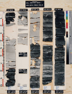 6506/12-4, 3129-3133 m |
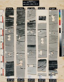 6506/12-4, 3134-3138 m |
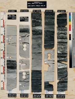 6506/12-4, 3139-3143 m |
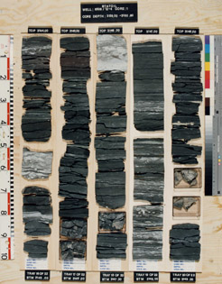 6506/12-4, 3144-3148 m |
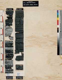 6506/12-4, 3149-3150 m |
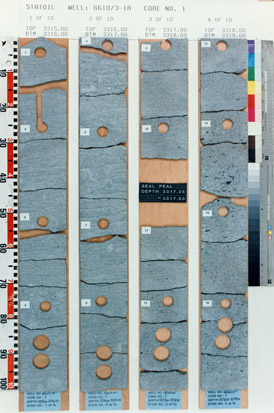 6610/3-1R, 3315-3319 m |
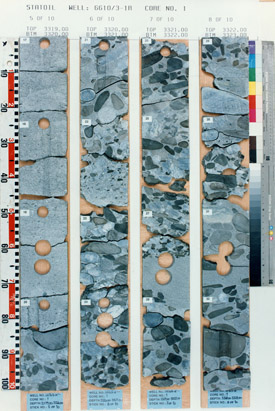 6610/3-1R, 3319-3323 m |
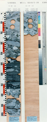 6610/3-1R, 3323-3324 m |
The Blålange Formation reaches a maximum thickness of 1573 m in the Helland Hansen well 6505/10-1, where it did not penetrate the base of the formation at TD (5031 m). It generally reaches in excess of 1000 m in wells in quadrants 6406 and 6506 on the Dønna Terrace e.g. 6506/6-1 (1114 m). Thicknesses in the Vøring Basin are difficult to establish since many wells have a TD within this formation but in well 6606/5-1 located on the Utgard High, 849 m of Blålange Formation was penetrated prior to the well TD at 3817 m. The Blålange Formation is generally thinner on the Trøndelags Platform, and in the Halten and Dønna Terrace areas it is between 300 m and 900 m thick.
WGS84 coordinates: N 65°10'07.58, E 06°43'44.07
UTM coordinates: 7229359.52 N 393591.68 E
UTM zone: 32
Drilling operator name: Den norske stats oljeselskap a.s (Statoil a.s.)
Completion date: 06.02.1985
Status: P & A
Interval of type section & thickness in type well:
3705 m - 3175 m, 530 m thickness.
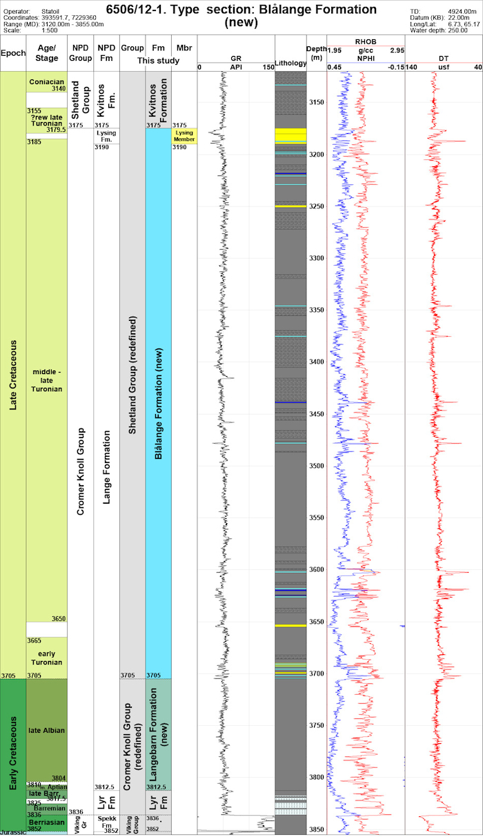
Logs of the type well 6506/12-1 (click to enlarge)
Two reference wells are designated, namely 6506/12-4 (Figure 3.15), the original reference well used by Dalland et al. (1988) to illustrate their Lange Formation (replaced herein) and in the upper part illustrating the (new) Blålange Formation, and well 6610/3-1R (Figure 3.16) to show variation in the formation in the Norwegian Sea.
Well name: 6506/12-4
WGS84 coordinates: N 65°12'46.97, E 06°43'30.37
UTM coordinates: 7234298.14 N 393591.29 E
UTM zone: 32
Drilling operator name: Den norske stats oljeselskap a.s. (Statoil a.s.)
Completion date: 13.08.1985
Status: P & A
Interval of reference section & thickness in reference well:
3738 m - 3132.5 m, 605.5 m thickness.
Well name: 6610/3-1R
WGS84 coordinates: N 66°55'29.70, E 10°54'06.28
UTM coordinates: 7424470.29 N 583170.04 E
UTM zone: 32
Drilling operator name: Den norske stats oljeselskap a.s (Statoil a.s.)
Completion date: 11.12.1993
Status: suspended, re-entered later.
Interval of reference section & thickness in reference well:
3412 m - 2655 m, 757 m thickness.
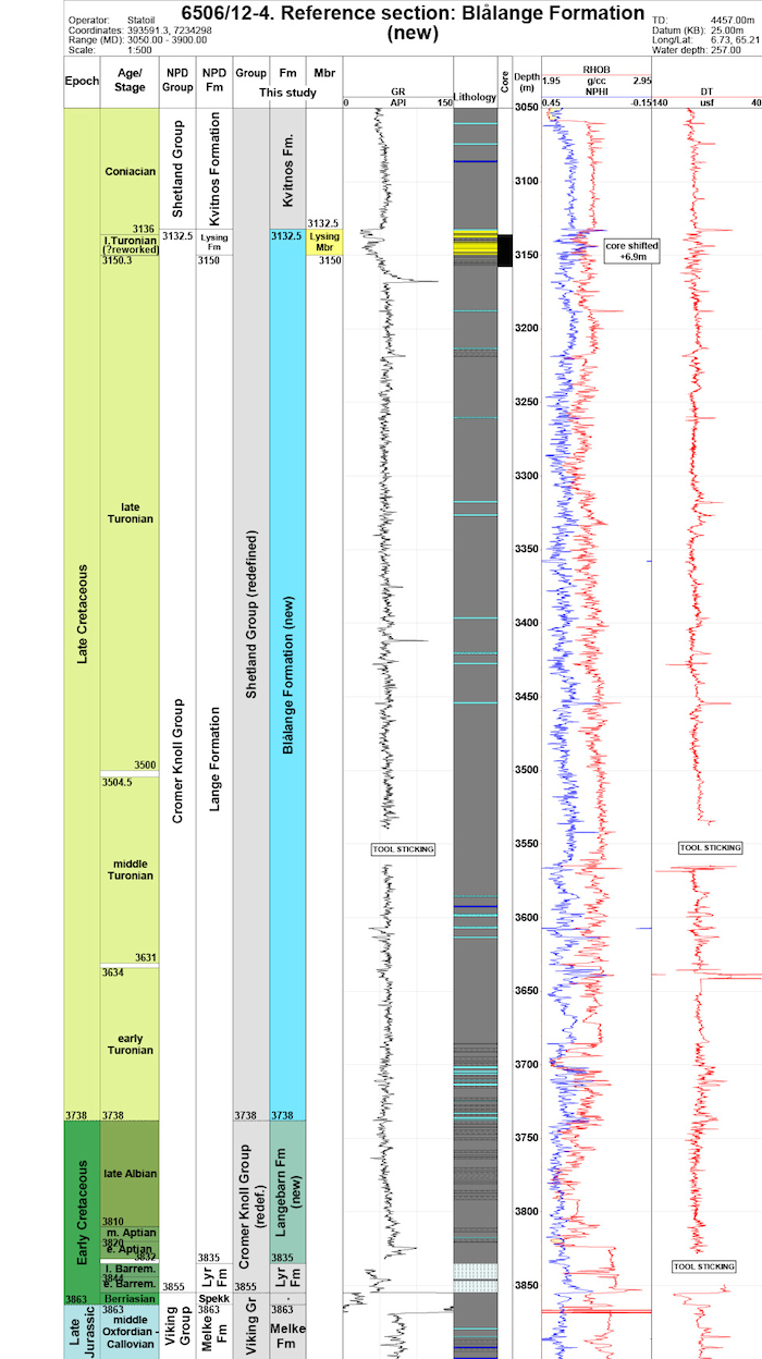 Reference well 6506/12-4 (click to enlarge) |
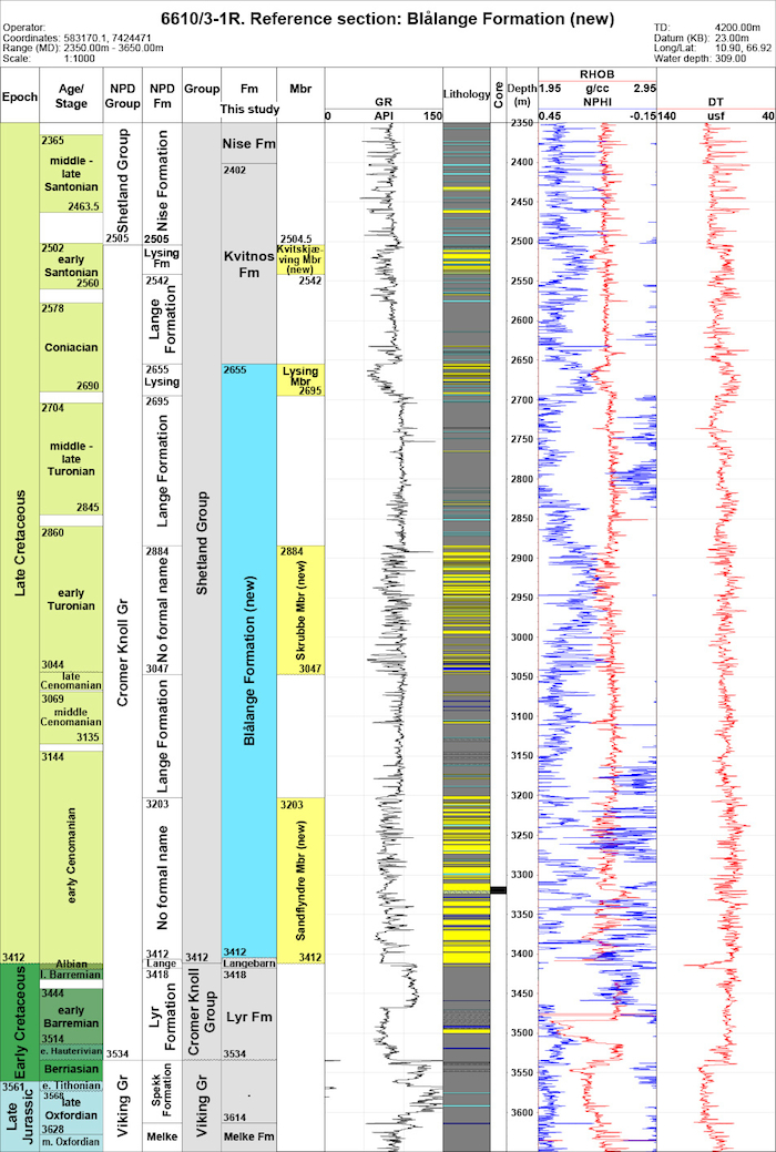 Reference well 6610/3-1R (click to enlarge) |
The top of the Blålange Formation normally coincides with the top of the Lysing Member in the Halten and Dønna Terraces, and in deep-water wells in the Vøring Basin. At these sites, the top of the Blålange Formation marks a downward change from mudstones of the Kvitnos Formation to sandstones and interbedded mudstones of the Lysing Member. This is typically defined by a marked downward decrease in gamma ray values and an increase in sonic velocity. In wells in quadrants 6406, 6407 and 6507, where the boundary represents a continuous sequence of mudstones, the boundary can be recognised by a slight downward decrease in average gamma ray values, an increase in average resistivity values and/or slight increase in average sonic velocity e.g. 6507/3-4. The latter probably relates to compactional differences of the mudstones.
The gamma-ray and sonic log profiles of the Blålange Formation are less uniform than those of the underlying Lange Formation, due to the frequency of thin bedded limestone stringers e.g. 6506/12-1. In addition, there are several high gamma spikes that are considered to represent thinly bedded tuffs. These provide a means of correlation between wells and are identified (in ascending order) as k54a to k58a (the 'a' suffix denoting presumed ash bed). On gamma logs these tend to have sharp, well defined bases and gradually decreasing upper values e.g. k55a, 6506/12-1, 3417m. These high gamma features appear to be restricted to the Blålange Formation and Turonian sediments, being absent in the overlying Kvitnos Formation. The k58a marker, e.g. 6506/12-4, 3168m is a regional marker that is typically developed towards the top of the Blålange Formation but below the Lysing Member and provides an independent stratigraphic means of distinguishing this unit from underlying, Turonian-restricted sandstones.
The main stratigraphic control of the Blålange Formation is provided by dinoflagellate cysts. Towards the
top of the formation and generally below the base of the
Lysing Member are the LO Stephodinium coronatum
and LO Cyclonephelium membraniphorum. This assemblage indicates a Turonian age. In this interval characteristic down-hole increases of specimens are observed of Palaeohystrichophora infusorioides and
Heterosphaeridium difficile.
In the type area on the Halten and Dønna Terraces, where the Blålange Formation rests unconformably upon the Lower Cretaceous Lange Formation (redefined), the oldest dinocyst markers are early Turonian in age, and include LAO Surculosphaeridium longifuratum, LCO C. membraniphorum and rare
Litosphaeridium
siphoniphorum. The FO H. difficile in sidewall or core samples provides a valuable datum to
identify an age
no older than Turonian and the degree of truncation e.g. 6506/12-1, 3696.5m (swc). It also provides a datum
to demonstrate any Cenomanian - Albian reworking from the underlying sediments. In the more complete
sections of the Vestfjorden Basin, the Blålange Formation extends older into the early Cenomanian and
contains the Sandflyndre Member. In this area, and represented by well 6610/3-1R, a more complete
and
typical Cenomanian succession of LO (few) Litosphaeridium siphoniphorum, LO Rhombodella
paucispina (late Cenomanian), LO Epelidosphaeridia spinosa (middle Cenomanian), LAO
'Sidridinium borealis'
and LO Ovoidinium verrucosum (early Cenomanian) is present in the lower part of the Blålange
Formation.
Micropalaeontologically, the Blålange Formation is generally devoid of calcareous foraminifera including planktonic types. Small, smooth Hedbergella spp, such as the LO Hedbergella delrioensis may be present in the upper part of this formation but generally planktonic foraminifera increase in numbers in the underlying Lange Formation (redefined), notably LCO Hedbergella. The exception being the stratigraphically more complete wells in the Vestforden area e.g. 6610/3-1R where planktonic foraminifera are frequent in the older i.e. Cenomanian part of the Blålange Formation. Influxes of 'cenosphaerid-type' radiolarians are typical of levels within the formation. Generally, the planktic bivalve Inoceramus is common in the overlying Kvitnos Formation and decreases in numbers above the Blålange Formation although this is probably related to post sedimentary, diagenetic processes rather than biostratigraphy.
The Blålange Formation is predominantly of Turonian age. In the type well 6506/12-1 the base of the Blålange Formation is typically unconformable with the underlying Lange Formation (redefined). This unconformity is regionally significant in the Halten-Dønna Terrace area, where the Blålange Formation progressively onlaps the Cromer Knoll Group. In the reference well 6610/3-1R, in the Vestfjorden area, the Blålange Formation extends to the base of the Cenomanian.
The Blålange Formation is laterally equivalent to the lower Kyrre Formation and the more calcareous Tryggvason Formation in the Shetland Group of the northern North Sea. Time equivalents to the North Sea Cenomanian Blodøks and Svarte Formations are generally not developed, being within the unconformity at the Blålange/Lange boundary. Equivalent sediments are sporadically present in the Vestfjorden Basin (Quadrant 6610) as sandstones of the Sandflyndre Member, and locally on the Halten and Dønna Terraces as sandstones and mudstones of the Gapeflyndre Member.
Færseth, R. and Lien, T. 2002. Cretaceous evolution in the Norwegian Sea - a period characterized by tectonic quiescence. Marine and Petroleum Geology, 19, 1005 -1027.
Gradstein, F., Kaminski, M.A. and Agterberg, F.P. 1999. Biostratigraphy and paleoceanography of the Cretaceous seaway between Norway and Greenland. Earth-Science Reviews, 46, 27-98.
Swiecicki, T., Gibbs, P.B., Farrow, G.E. and Coward, M.P. 1998. A tectonostratigraphic framework for the Mid-Norway region. Marine and Petroleum Geology, 15, 245-276.
Vergara, L., Wreglesworth, I., Trayfoot, M., Richardsen, G. 2001. The distribution of Cretaceous and
Paleocene deep-water reservoirs in the Norwegian Sea basins. Petroleum Geoscience, 7, 395-408.
| home | previous page |