 |
|
 |
|
updated to follow: Stratigraphic Guide to the Cromer Knoll, Shetland and Chalk Groups of the North Sea and Norwegian Sea. Felix M. Gradstein & Colin C. Waters (editors), Mike Charnock, Dirk Munsterman, Michelle Hollerbach, Harald Brunstad, Øyvind Hammer & Luis Vergara (contributors). Newsletter on Stratigraphy, vol 49/1 pp71-280, 2016
Shetland Group, Blålange FormationDerivatio nominis: The Skolest Member is derived from the Norwegian for the fish species Corypheonides rupestris or round-nosed grenadier. This relative of the cod is a benthopelagic to bathypelagic fish usually found from 400 m to 1200 m water depth in the North Atlantic and Norwegian Sea and locally in either the Norwegian fjords or on the banks off the coast of Møre and Trøndelag.
The Skolest Member consists of sandstones and minor, subordinate mudstones.
The sandstones are white - light grey, clear to translucent quartz, predominantly fine grained but maybe very fine to coarse grained, angular to sub-rounded, predominantly moderately sorted, loose grains with traces of calcareous cement, firm to moderately hard, with trace to abundant glauconite, rarely micaceous and rare pyrite.
The mudstones are medium dark grey - dark grey, sub-blocky, firm to moderately hard, non-calcareous, traces of micro-micaceous and rare traces of micro-pyrite.
The Skolest Member is between 10 m - 25 m thickness based on the available limited well data.
Based on the available, but limited well data, sandstones of the Skolest Member are developed in the northern area of the Ormen Lange Field in quadrant 6305 and in the Slørebotn sub-basin, quadrant 6306, towards the eastern margin of the Møre Basin.
Reference well 6306/10-1: No slides are available from this member at the NPD.
Reference well 6306/10-1: no cores taken in this member.
WGS84 coordinates: N 63°46'59.72", E 05°16'19.57"
UTM coordinates: 7075028.48 N 611981.31 E
UTM zone: 31
Drilling operator name: Norsk Hydro Produksjon A/S
Completion date: 19.11.1998
Status: P & A
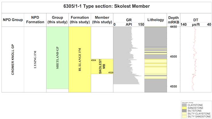
Interval of type section (m) & thickness in type well:
4529 m - 4504 m, 25 m thickness.

Logs of the type well 6305/1-1 (click to enlarge)
WGS84 coordinates: N 63°09'26.32", E 06°19'41.45"
UTM coordinates: 7006099.05 N 365416.35 E
UTM zone: 32
Drilling operator name: A/S Norske Shell
Completion date: 17.12.1990
Status: P & A
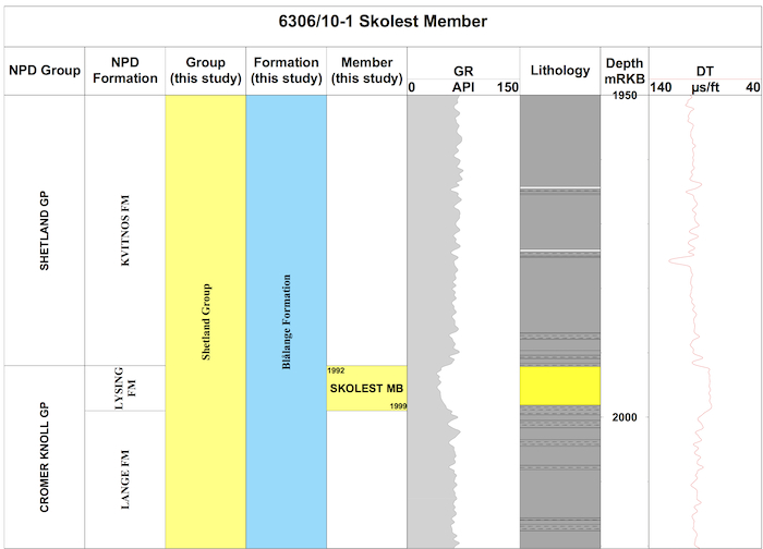
Interval of reference section (m) & thickness in reference well:
1999 m - 1992 m, 7 m thickness.

Logs of the type well 6306/10-1 (click to enlarge)
In the type well 6305/1-1 the base of the Skolest Member is taken at 4529mMD RKB, and is characterised by a change from mudstones of the underlying Blålange Formation to predominantly sandstones of the Skolest Member. On wireline logs the change is marked by a distinct decrease in gamma ray and density log values, and an increase in sonic velocities.
The lower boundary is more marked on resistivity logs where the boundaries is represented by an abrupt upward increase in values and the unit is characterised by a uniform resistivity log profile. In the reference well 6306/10-1, the lower boundary at 1999mMD RKB has a similar transitional decrease in gamma ray values, but a more distinct increase in sonic velocities and increase in resistivity values.
In the reference well 6306/10-1, the Skolest Member is developed below the Tunge Member of Coniacian age and within a 'latest' middle - late Turonian age interval. The dinocyst marker LO Microdinium setosum below the member defines an intra-middle Turonian level and above the Skolest Member is an influx of planktonic foraminifera with LAO Hedbergella delrioensis and the dinocyst LO Stephodinium coronatum characteristic of the late Turonian. The Skolest Member is therefore developed close to the middle/late Turonian boundary.
The sandstones of the Skolest Member pass laterally into mudstones of the Blålange Formation.
The Skolest Member is stratigraphically older than the Lysing Member of the Halten-Dønna Terrace area and the Møre Basin equivalent Tunge Member. This relationship may be demonstrated in the reference well 6306/10-1. It is therefore part of the K70 sequence of Vergara et al. (2001), K50 sequence of Færseth and Lien (2002) and Lien (2005) and K67 - K68 sequence of Fugelli and Olsen (2005a).
There is limited data available on the depositional setting of the Skolest Member. No cores were taken. In the absence of any apparent stratigraphic breaks in the adjacent sections it is likely to be at least below storm base level. Marine microplankton diversity is high (30-40 species), and suggests an open marine, offshore environment. In terms of benthic foraminiferal biofacies the assemblage is impoverished. Tubular deep water agglutinated foraminifera DWAF are common in the overlying Blålange Formation down to 4130mMD, reflecting a deep marine environment and coinciding with a level associated with an up-section decrease in average sonic velocities. Below this level 4134m MD - 4560m MD TD within the development of the Skolest Member, recovery is poor and largely dominated by pyritised microfossils.
Fugelli, E. and Olsen T. R. 2005a. Screening for deep-marine reservoirs in frontier basins: Part 1 - Examples from offshore mid- Norway. AAPG Bulletin 89(7):853-882.
Lien, T. 2005. From rifting to drifting: effects on the development of deep-water hydrocarbon reservoirs in a passive margin setting, Norwegian Sea. Norwegian Journal of Geology 85:319-332.
Vergara, L., Wreglesworth, I., Trayfoot, M., Richardsen, G. 2001. The distribution of Cretaceous
and Paleocene deep-water reservoirs in the Norwegian Sea basins.
Petroleum Geoscience 7:395-408.
| home | previous page |