 |
|
|
|
|
from: Dallmann. W.K. (ed.). Svalbard lithostratigraphic lexicon
TEMPELFJORDEN GROUP (CP-78)  STATUS OF UNIT: Formal
FIRST USE OF NAME: Cutbill & Challinor 1965 CURRENT DEFINITION: Cutbill & Challinor 1965 SYNONYM(S) AND REFERENCE(S): None ORIGIN OF NAME: Tempelfjorden (transl. "Temple Fiord"): A fiord between Bünsow Land and Sabine Land, central Spitsbergen TYPE AREA: Mountain areas in Dickson Land and Bünsow Land, central Spitsbergen STRUCTURAL SETTING: Late Palaeozoic platform of Svalbard/Barents Sea Shelf DEPOSITIONAL AGE: Late Artinskian - Kazanian (?Tatarian) OVERLYING UNIT(S): Sassendalen Group UNDERLYING UNIT(S): Gipsdalen Group, Bjarmeland Group SUPERIOR UNIT: None OTHER USE OF NAME: None THICKNESS: Up to 460 m MAIN LITHOLOGIES: Chert, siliceous shale, sandstone, limestone DESCRIPTION: The group consists of siliceous (spiculitic) shales, siltstones and cherts with intercalated minor sandstones and limestones of mid- to late Permian age, overlying the carbonates of the Gipsdalen Group. Both litho- and biofacies contrast strongly with those of the underlying group, indicating a hydrographic shift to cooler water conditions. The generally deeper water facies represented in this group also suggest large-scale sea level rise accompanying rifting and establishment of a marine passage from the Boreal Sea in the Barents Sea Region to the North Sea area. The Tempelfjorden Group at present comprises three laterally equivalent formations: Kapp Starostin Formation (Spitsbergen and eastern islands), Tokrossøya Formation (Sørkapp area) and Miseryfjellet Formation (Bjørnøya). Similar successions seen in offshore wells throughout the Barents Sea Shelf will undoubtedly augment present knowledge of the group's development. KAPP STAROSTIN FORMATION (CP-79) 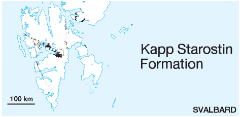 DISTRIBUTION shown on Fig. 2-06, Fig. 2-07, Fig. 2-08, Fig. 2-09, Fig. 2-10
STATUS OF UNIT: Formal FIRST USE OF NAME: Cutbill & Challinor 1965 CURRENT DEFINITION: Cutbill & Challinor 1965 SYNONYM(S) AND REFERENCE(S): "Brachiopod formation": Nordenskiöld 1863; "Brachiopod Cherts": Gee et al. 1952; "Starostin Formation": Burov et al. 1965. The "Starostin Formation" as defined by Burov et al. (1965) does not contain the Selanderneset member, which is considered as an individual formation by them. ORIGIN OF NAME: Kapp Starostin: A point on the southern coast of outer Isfjorden. TYPE SECTION (Fig. 2-110): Stratotype: Kapp Starostin, outer Isfjorden STRUCTURAL SETTING: Late Palaeozoic platform of Svalbard/Barents Sea Shelf DEPOSITIONAL AGE: Late Artinskian - Kazanian DATING METHOD: Various fossils REFERENCE(S) FOR AGE: Biernat & Birkenmajer 1981; Nakamura et al. 1987; Stemmerik 1988; Nakrem 1988, 1991; Nakrem et al. 1992 OVERLYING UNIT(S): Vardebukta and Vikinghøgda formations UNDERLYING UNIT(S): Gipshuken Formation SUPERIOR UNIT: Tempelfjorden Group OTHER USE OF NAME: None THICKNESS: Up to 460 m, 380 m in stratotype MAIN LITHOLOGIES: Chert, siliceous shale, sandstone, limestone LOWER BOUNDARY DEFINITION: The base of the formation is almost everywhere defined by the onset of the Vøringen Member, a distinct marker bed composed of bioclastic limestone, overlying the dolomitic lithologies of the Gipshuken Formation. DESCRIPTION: The Kapp Starostin Formation is developed throughout Spitsbergen and Nordaustlandet in all localities east and north of the Sørkapp-Hornsund High (Fig. 2-107, Fig. 2-108, Fig. 2-109). Its upper parts are also poorly exposed on Edgeøya and Barentsøya. It is 460 m thick in the St. Jonsfjorden Trough, 380 m in the type section at Isfjorden, and thins to a few metres, and finally pinches out, on the eastern margins of the Sørkapp-Hornsund High. Lithologies are spiculitic cherts, shales and siltstones, siliceous sandstones and limestones, and dolomites. The overall stratigraphic development is not understood well yet, and the member subdivision of the formation is largely of a preliminary, informal character. 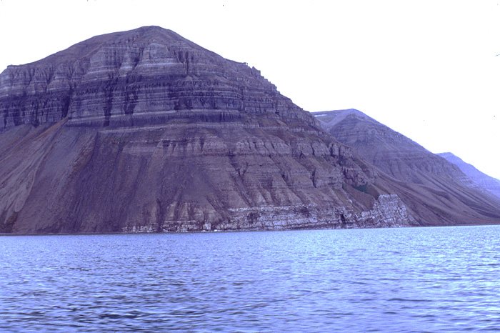
Fig. 2-107: A typical cliff formed by the cherts, spiculitic limestones and sandstones of the Kapp Starostin Formation (upper half of slope) at Skansen (Billefjorden). Photo: J. Nagy 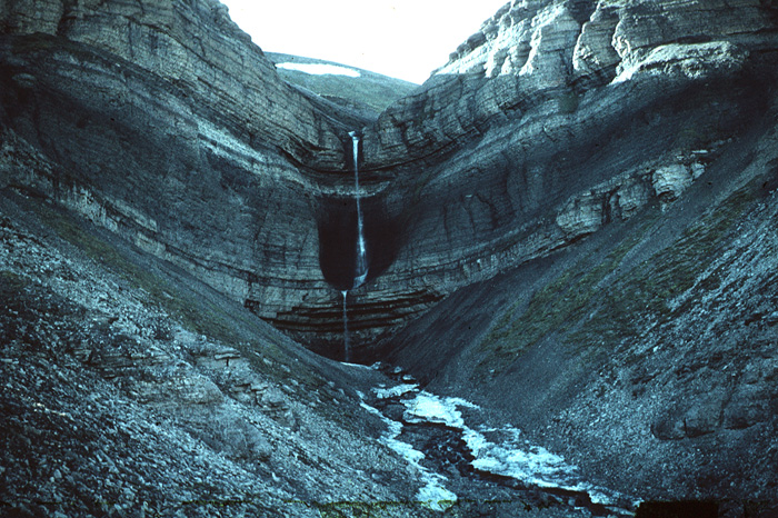
Fig. 2-108: Alternating cherts and spiculitic carbonate rocks of the Kapp Starostin Formation at Skansbukta (Billefjorden). Photo: J. Nagy 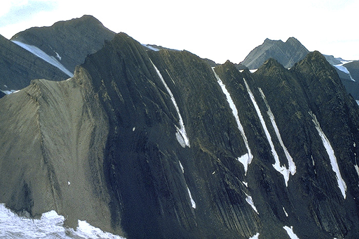
Fig. 2-109: Section through the Kapp Starostin Formation in western Nordenskiöld Land showing five depositional units of cherts and other spiculitic lithologies. Photo: E.P. Johannessen Detailed local descriptions are provided by a number of unpublished theses: Bottolfsen (1994), Cutler (1981), Fredriksen (1988), Hellem (1980), Henriksen (1988), Knag (1980), Saalmann (1995). 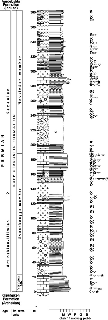
Fig. 2-110: Stratigraphic section CP-79/80/81/82. Stratotype for: Kapp Starostin Formation, Vøringen, Svenskeegga and Hovtinden members. Locality: Kapp Starostin, Festningen section. Reference: Hellem 1980 (unpubl.) Vøringen Member (CP-80) STATUS OF UNIT: Formal FIRST USE OF NAME: Cutbill & Challinor 1965 CURRENT DEFINITION: Cutbill & Challinor 1965 SYNONYM(S) AND REFERENCE(S): "Limestone A": Forbes et al. 1958 ORIGIN OF NAME: Vøringen (named after a vessel): A mountain in western Nordenskiöld Land, close to the type locality TYPE SECTION (Fig. 2-110): Stratotype: Kapp Starostin, outer Isfjorden DEPOSITIONAL AGE: Late Artinskian - Kungurian. The Vøringen Member probably corresponds in age to the upper part of the Hambergfjellet Formation and/or the hiatus between the Hambergfjellet and Miseryfjellet formations on Bjørnøya. DATING METHOD: See Kapp Starostin Formation REFERENCE(S) FOR AGE: See Kapp Starostin Formation OVERLYING UNIT(S): Svenskeegga member UNDERLYING UNIT(S): Gipshuken Formation SUPERIOR UNIT: Kapp Starostin Formation OTHER USE OF NAME: None THICKNESS: Up to 40 m, 22 m in stratotype MAIN LITHOLOGIES: Bioclastic limestone LOWER BOUNDARY DEFINITION: The base is defined at the onset of bioclastic limestone above the dolomitic lithologies of the Gipshuken Formation. DESCRIPTION: The Vøringen Member consists of limestones rich in brachiopods, bryozoans, crinoids and other marine fossils. It is a transgressive unit and forms widespread and prominent cliffs above the more easily weathered dolomitic limestones of the upper Gipshuken Formation. The member is used as a marker almost throughout Svalbard. It does not occur in northern Oscar II Land including Brøggerhalvøya. Svenskeegga member (CP-81) STATUS OF UNIT: Informal FIRST USE OF NAME: Cutbill & Challinor 1965 CURRENT DEFINITION: Cutbill & Challinor 1965 SYNONYM(S) AND REFERENCE(S): None ORIGIN OF NAME: Svenskeegga (transl. "The Swede Crest"): A mountain crest in southern Oscar II Land TYPE SECTION (Fig. 2-110)): Stratotype: Kapp Starostin, outer Isfjorden DEPOSITIONAL AGE: Kungurian - ?Kazanian DATING METHOD: See Kapp Starostin Formation REFERENCE(S) FOR AGE: See Kapp Starostin Formation OVERLYING UNIT(S): Hovtinden member UNDERLYING UNIT(S): Vøringen Member SUPERIOR UNIT: Kapp Starostin Formation OTHER USE OF NAME: None THICKNESS: 150-230 m, 165 m in stratotype MAIN LITHOLOGIES: Spiculitic shale, chert, siltstone, limestone LOWER BOUNDARY DEFINITION: The lower boundary is defined, where clastic lithologies conformably overly the bioclastic limestone of the Vøringen Member. DESCRIPTION: The Svenskeegga member is only defined in its type area at outer Isfjorden. Stratigraphic relations to other sections of the Kapp Starostin Formation are not yet understood. The unit consists of cherts and spiculitic shales as well as siliceous limestones with sponges and sponge spicula, brachiopods (abundant productids and spiriferids), bryozoans and trace fossils (e.g. Zoophycos). A bioclastic limestone marker bed occurs uppermost in the unit in the Festningen section. Bioturbation and faunas suggest deep marine shelf conditions. Hovtinden member (CP-82) STATUS OF UNIT: Informal FIRST USE OF NAME: Cutbill & Challinor 1965 CURRENT DEFINITION: Cutbill & Challinor 1965 SYNONYM(S) AND REFERENCE(S): None ORIGIN OF NAME: Hovtinden (transl. "The Hoof Pinnacle"): A mountain summit in southern Oscar II Land TYPE SECTION (Fig. 2-110): Stratotype: Kapp Starostin, outer Isfjorden DEPOSITIONAL AGE: ?Kazanian DATING METHOD: See Kapp Starostin Formation REFERENCE(S) FOR AGE: See Kapp Starostin Formation OVERLYING UNIT(S): Vardebukta Formation UNDERLYING UNIT(S): Svenskeegga member SUPERIOR UNIT: Kapp Starostin Formation OTHER USE OF NAME: None THICKNESS: 200-230 m, 196 m in stratotype MAIN LITHOLOGIES: Silicified shale, siltstone, sandy limestone LOWER BOUNDARY DEFINITION: The base is defined, where shales, sandy cherts or cherty sandstones conformably overlie the bioclastic limestone interval in the upper part of the Svenskeegga member. The boundary is not defined outside the type area. DESCRIPTION: The Hovtinden member is only defined in its type area at outer Isfjorden. Stratigraphic relations to other sections of the Kapp Starostin Formation are not yet understood. The unit consists of silica-cemented shales, siltstones and sandstones, as well as thin intercalated limestones. The uppermost part of the unit at Festningen shows a slight upwards coarsening trend into silty shales with a decreasing spiculite content. Revtanna member (CP-83) STATUS OF UNIT: Informal FIRST USE OF NAME: Here CURRENT DEFINITION: Here, following Knag (1980, unpubl.) SYNONYM(S) AND REFERENCE(S): None ORIGIN OF NAME: Revtanna (transl. "The Fox Tooth"): A mountain in northern Wedel Jarlsberg Land TYPE SECTION (Fig. 2-111): Stratotype: Revtanna, northern Wedel Jarlsberg Land DEPOSITIONAL AGE: ?Kazanian DATING METHOD: Indirect, stratigraphic relationships REFERENCE(S) FOR AGE: See Kapp Starostin Formation OVERLYING UNIT(S): Vardebukta Formation UNDERLYING UNIT(S): Not named SUPERIOR UNIT: Kapp Starostin Formation OTHER USE OF NAME: None THICKNESS: Up to 85 m MAIN LITHOLOGIES: Sandstone, shale, siltstone, limestone LOWER BOUNDARY DEFINITION: The lower boundary of the member in the type section is defined at the bottom of a distinct sandstone interval, resting conformably on a limestone bed 58 m above the base of the Kapp Starostin Formation. DESCRIPTION: The Revtanna member comprises the sandstone-dominated, upper part of the Kapp Starostin Formation in SW Spitsbergen, along the eastern margins of the Sørkapp Hornsund High. The unit consists of three coarsening-upward sequences, each starting with a thin limestone grading up via dark shales or siltstones into very fine or fine clayey quartz sandstones often rich in glauconite. The thickness of the member (82 m in the type section) decreases southward towards the Sørkapp-Hornsund High. Northward, the member interfingers with the dark spiculitic mudstones, limestones and siltstones of the Hovtinden Member. 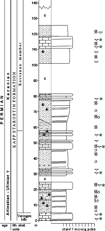
Fig. 2-111: Stratigraphic section CP-83. Stratotype for: Revtanna member. Locality: Revtanna. Reference: Knag 1980 (unpubl.) Stensiöfjellet member (CP-84) STATUS OF UNIT: Informal FIRST USE OF NAME: Here CURRENT DEFINITION: Here SYNONYM(S) AND REFERENCE(S): None ORIGIN OF NAME: Stensiöfjellet: A mountain in Sabine Land TYPE SECTION (Fig. 2-112): Stratotype: Stensiöfjellet, Sabine Land DEPOSITIONAL AGE: ?Kazanian DATING METHOD: Indirect, stratigraphic relationships REFERENCE(S) FOR AGE: See Kapp Starostin Formation OVERLYING UNIT(S): Vardebukta and Vikinghøgda formations UNDERLYING UNIT(S): Not named SUPERIOR UNIT: Kapp Starostin Formation OTHER USE OF NAME: None THICKNESS: Up to 60 m, 27 m in stratotype MAIN LITHOLOGIES: Sandstone, chert LOWER BOUNDARY DEFINITION: The base of the member occurs 30 m below the Triassic base on the western slope of Stensiöfjellet (type locality), at the base of a massive sandstone succession. DESCRIPTION: The Stensiöfjellet member forms a thick sandstone wedge in the uppermost part of the Kapp Starostin Formation in northwestern and central Spitsbergen. The member consists of irregularly interbedded glauconitic sandstones and sandy, spiculitic cherts. Sporadic coquina lags and brachiopod shells occur. The unit's greenish colour in the field reflects its high glauconite content. The lower boundary is gradational from light spiculitic cherts or silicified coquina limestones. The maximum thickness of ca. 60 m occurs in the Billefjorden area and on Brøggerhalvøya. The unit is not correlative with or laterally equivalent to the Selanderneset member. 
Fig. 2-112: Stratigraphic section CP-84. Stratotype for: Stensiöfjellet member. Locality: Stensiöfjellet. Reference: Hellem, T. & Worsley, D. (unpubl.) Palanderbukta member (CP-85) STATUS OF UNIT: Informal FIRST USE OF NAME: Lauritzen 1981 CURRENT DEFINITION: Lauritzen 1981 SYNONYM(S) AND REFERENCE(S): None ORIGIN OF NAME: Palanderbukta: A fiord in southwestern Nordaustlandet TYPE SECTION (Fig. 2-113): Stratotype: Zeipelfjella W, Palanderbukta, Nordaustlandet DEPOSITIONAL AGE: Kungurian - ?Ufimian DATING METHOD: Conodonts REFERENCE(S) FOR AGE: Nakrem et al. 1992 OVERLYING UNIT(S): Not named UNDERLYING UNIT(S): Not named SUPERIOR UNIT: Kapp Starostin Formation OTHER USE OF NAME: None THICKNESS: 17.5 m in stratotype MAIN LITHOLOGIES: Limestone, chert LOWER BOUNDARY DEFINITION: The base of the member is marked by a sharp lithological break at 46.5 m (in the type section) above the base of the Kapp Starostin Formation. DESCRIPTION: The Palanderbukta member is only observed on Nordaustlandet. It is dominated by limestones which are extremely fossiliferous (brachiopods, subordinate corals). Prevailing lithologies are sandy biosparites, subordinate cherty biosparites and chert. An almost white, 2 m thick chert bed is found in the lower part of the unit. The member often has a characteristic green colour caused by the presence of glauconite, and some beds consist of almost pure glauconite sandstone. 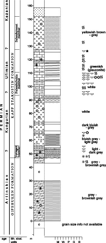
Fig. 2-113: Stratigraphic section CP-85. Stratotype for: Palanderbukta member. Locality: Palanderbukta, Zeipelfjella. Reference: Lauritzen 1981 Selanderneset Member (CP-86) STATUS OF UNIT: Informal FIRST USE OF NAME: Burov et al. 1965 CURRENT DEFINITION: Here SYNONYM(S) AND REFERENCE(S): "Selander Suite": Burov et al. 1965 ORIGIN OF NAME: Selanderneset: A cape on southwestern Nordaustlandet, at Hinlopenstretet TYPE SECTION (Fig. 2-114, Fig. 2-115): Unit stratotype: Angelinberget, Selanderneset, Nordaustlandet. Boundary and Hypostratotype: Eremitten, Vaigattbogen, Olav V Land DEPOSITIONAL AGE: ?Kazanian DATING METHOD: Indirect, stratigraphic relationships REFERENCE(S) FOR AGE: Nakrem et al. 1992 OVERLYING UNIT(S): Not named UNDERLYING UNIT(S): Not named SUPERIOR UNIT: Kapp Starostin Formation OTHER USE OF NAME: None THICKNESS: 30-300 (?) m MAIN LITHOLOGIES: Sandstone, sandy limestone LOWER BOUNDARY DEFINITION: The lower boundary is defined by beds of glauconitic sandstones resting conformably0 on spiculitic cherts of the underlying part of the formation. 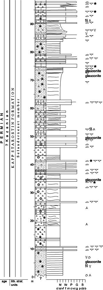
Fig. 2-114: Stratigraphic section CP-86a. Unit stratotype for: Selanderneset member. Locality: Angelinberget, Selanderneset. Reference: Hellem, T. & Worsley, D. (unpubl.) 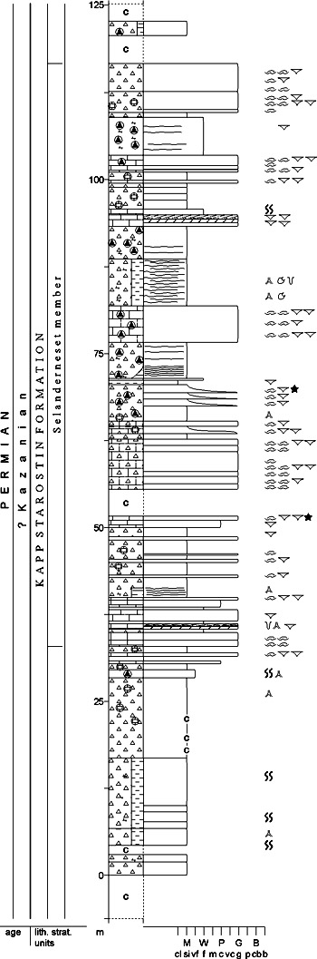
Fig. 2-115: Stratigraphic section CP-86b. Boundary stratotype for: Selanderneset member. Locality: Eremitten. Reference: Hellem, T. & Worsley, D. (unpubl.) DESCRIPTION: Glauconitic sandstones and sandy coquina limestones herein defined as the Selanderneset member occur in the upper part of the Kapp Starostin Formation on Nordaustlandet and in the Lomfjorden area, northeastern Spitsbergen. This usage is more restricted – both stratigraphically and geographically – than the original "Selander Suite" introduced by Burov et al. (1965). The top is defined by a higher level of spiculitic cherts. Though the member is defined by a higher level of spicitalitic cherts. Though the member is defined by the type locality at Selanderneset, the good exposure at Eremitten (Vaigattbogen, northern Olav V Land) are used as a boundary and hypostratotype. The member is 85 m thick here and outcrops between 135 m and 220 m above sea-level on the mountain's northeastern slopes. The member thins westward and passes into spiculitic cherts and shales. It consists of three course sandy limestone to sandstone units with spiculitic interbeds between each of these. Back to top Tokrossøya Formation (CP-87) 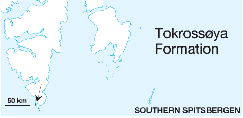 DISTRIBUTION shown in Fig. 2-06
STATUS OF UNIT: Formal FIRST USE OF NAME: Siedlecki 1964 CURRENT DEFINITION: Siedlecka 1970 SYNONYM(S) AND REFERENCE(S): Tokrossøya "Beds": Siedlecki 1964; Brahiopod Cherty Limestone: Birkenmajer & Czarniecki 1960. Formation rank was introduced by Cutbill & Challinor (1965). ORIGIN OF NAME: Tokrossøya (transl. "Island of the two crosses"): A small island close to the southernmost tip of Spitsbergen TYPE SECTION (Fig. 2-116): Stratotype:Tokrossøya N, Sørkapp Land STRUCTURAL SETTING: Late Palaeozoic platform of Svalbard/Barents Sea Shelf DEPOSITIONAL AGE: ?Kungurian - ?Kazanian DATING METHOD: Invertebrate fossils REFERENCE(S) FOR AGE: Nakrem et al. 1992 OVERLYING UNIT(S): Vardebukta Formation UNDERLYING UNIT(S): Not exposed SUPERIOR UNIT: Tempelfjorden Group OTHER USE OF NAME: None THICKNESS: Up to ca. 425 m exposed MAIN LITHOLOGIES: Chert, siliceous limestone, sandstone LOWER BOUNDARY DEFINITION: The lower boundary is not exposed. DESCRIPTION: The Tokrossøya Formation represents the Tempelfjorden Group on the southwestern side of the Sørkapp-Hornsund High. The present exposures are probably thrust in from the west during the Palaeogene tectonic event. The basal part of the Tokrossøya Formation is not exposed. The most complete section of 300 m thickness is exposed on Tokrossøya (type section). Siedlecka (1970) pointed out that the original description of Siedlecki (1964) presented the unit in inverted succession; these authors divided the succession into Lower and Upper "Tokrossøya beds", the lower being dominated by arenaceous, calcareous, spiculitic cherts or spiculites, and the upper by arenaceous, cherty limestones and overlying calcareous sandstones and siltstones. On øyrlandet and Tokrossøya, the two members are divided by one or several, up to 20 m thick layers of silica-cemented, medium-grained quartz sandstones (Sandhamna beds). Glauconite is present in nearly all rock types. Macrofossils (spiriferids, productids, bryozoans and occasionally sponges) occur predominantly and abundantly within the upper member, but also less frequently at certain levels of the lower member. Pectenids are found in some places within the lower member. Plant remains occur within the quartz sandstones and intercalated arenaceous limestones on øyrlandet. Siedlecka (1970) provided a detailed sediment-petrologic analysis of the individual rock types and concluded that the sediments were deposited in an epicontinental marine environment with a maximum transgression during the deposition of the cherts of the lower member under relatively deep, quiet, restricted conditions, probably within depressions on the outer shelf. The arenaceous rocks of the upper member indicate shallowing and littoral influx. 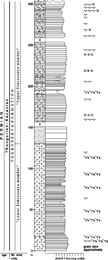
Fig. 2-116: Stratigraphic section CP-87. Stratotype for: Tokrossøya Formation. Locality: Tokrossøya N. Reference: Dallmann et al. 1993, redrawn from Siedlecka 1970 Sandhamna beds (CP-88) STATUS OF UNIT: Informal FIRST USE OF NAME: Here CURRENT DEFINITION: Here SYNONYM(S) AND REFERENCE(S): None ORIGIN OF NAME: Sandhamna: A bay in SW øyrlandet, southern Sørkapp Land TYPE SECTION (Fig. 2-117): Sandhamna, øyrlandet SW Sørkapp Land DEPOSITIONAL AGE: ?Ufimian - ?Kazanian DATING METHOD: Indirect, stratigraphic relationships REFERENCE(S) FOR AGE: See Tokrossøya Formation OVERLYING UNIT(S): Not named UNDERLYING UNIT(S): Not named SUPERIOR UNIT: Kapp Starostin Formation OTHER USE OF NAME: None THICKNESS: ca. 70 m stratotype MAIN LITHOLOGIES: Sandstone LOWER BOUNDARY DEFINITION: The base of the unit is the first massive sandstone bed in the middle part of the Tokrossøya Formation. DESCRIPTION: The Sandhamna beds occur on both sides of the NNW-SSE trending syncline passing through øyrlandet. On the SSW fold limb, they run from Sandhamna to Skjerodden; on the NNE fold limb, they occur on øyrlandsodden and Tokrossøya. They reappear on Sørkappøya. The Sandhamna beds comprise one or up to four, up to 20 m thick sandstone beds, intercalated with arenaceous cherty limestones of the middle part of the Tokrossøya Formation. The sandstones are silica-cemented, mediumgrained quartz sandstones with a distinct glauconitic component. 
Fig. 2-117: Stratigraphic section CP-88. Stratotype for: Sandhamna beds. Locality: Sandhamna. Reference: Dallmann et al. 1993, redrawn from Siedlecka 1970 Back to top MISERYFJELLET FORMATION (CP-89)  DISTRIBUTION shown on Fig. 2-05
STATUS OF UNIT: Formal FIRST USE OF NAME: Worsley & Edwards 1976 CURRENT DEFINITION: Worsley & Edwards 1976 SYNONYM(S) AND REFERENCE(S): "Spirifer limestone": Andersson 1900; "Laksvatnet Formation": Krasil'ščikov & Livšic 1974. Although Krasil'ščikov & Livšic (1974) publication with the name "Laksvatnet Formation" was issued earlier, the manuscripts were written simultaneously. This is valid for several units on Bjørnøya. We recommend the use of Worsley & Edward's (1976) nomenclature, because this is better established in the published literature. ORIGIN OF NAME: Miseryfjellet: A mountain on Bjørnøya TYPE SECTION (Fig. 2-119): Stratotype: Brettingsdalen, Miseryfjellet, Bjørnøya STRUCTURAL SETTING: Late Palaeozoic platform of Svalbard/Barents Sea Shelf DEPOSITIONAL AGE: Kungurian - Ufimian DATING METHOD: Conodonts REFERENCE(S) FOR AGE: Nakrem 1991 OVERLYING UNIT(S): Urd Formation UNDERLYING UNIT(S): Røedvika, Nordkapp, Landnørdingsvika, Kapp Kåre, Kapp Dunér and Hambergfjellet formations SUPERIOR UNIT: Tempelfjorden Group OTHER USE OF NAME: "Misery Subformation": Pavlov et al. 1983 THICKNESS: 90-115 m MAIN LITHOLOGIES: Siliceous limestone, sandstone LOWER BOUNDARY DEFINITION: The basis is defined at the overstep unconformity, where Kungurian sandstones and conglomerates overlie various older formations. 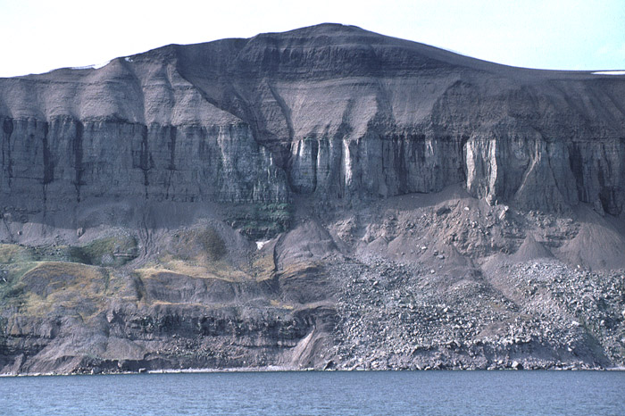
Fig. 2-118: Miseryfjellet on Bjørnøya, seen from the east. The steep wall in the middle of the slope consists of the siliceous rocks of the Miseryfjellet Formation, morphologically well distinguished from the underlying Late Devonain Røedvika Formation and the overlying Triassic strata (Urd and Skuld formations). Photo: W.K. Dallmann DESCRIPTION: Basal sandstones and conglomerates onlap and overstep all older units on Bjørnøya. Locally these basal beds fill up to 10 m deep karstic features in underlying dolomites of the Kapp Dunér Formation. Most of the formation consists of partially silicified grainstones and packstones, with a 12 m thick cross-bedded quartzitic sandstone developed 20 m above the base of the unit. A rich fauna of brachiopods, bryozoans and crinoids is very similar to that of correlatives on Spitsbergen (e.g. Gobbett 1963). Outliers on the island's northern coast preserve only the lowermost 10 m to 15 m of the formation. (Fig. 2-118) 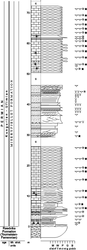
Fig. 2-119: Stratigraphic section CP-89. Stratotype for: Miseryfjellet Formation. Locality: Brettingsdalen, Miseryfjellet. Reference: Hellem, T. & Worsley, D. (unpubl.) Back to top |