|
|
|
|
|
from: Dallmann. W.K. (ed.). Svalbard lithostratigraphic lexicon
[ Vardebukta Formation | Tvillingodden Formation | Vikinghøgda Formation | Urd Formation ]
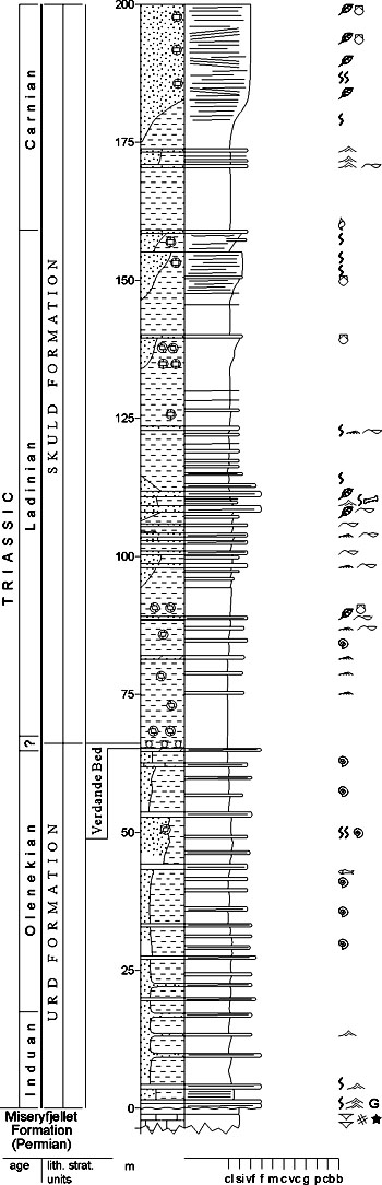
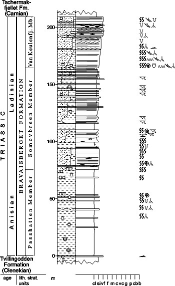
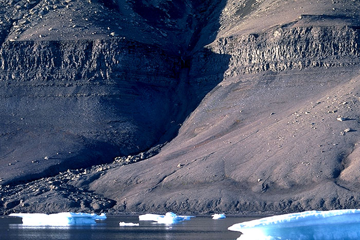
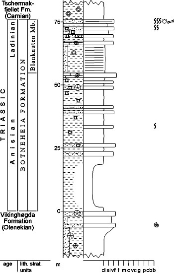
[ Bravaisberget Formation | Botneheia Formation | Steinkobbe Formation | Ingøydjupet Subgroup ] [ Havert Formation | Klappmyss Formation | Kobbe Formation ] SASSENDALEN GROUP (M-01) 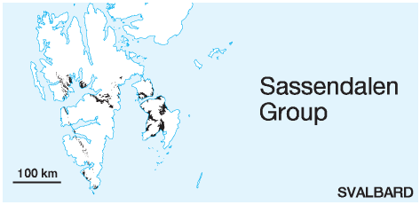 STATUS OF UNIT: Formal FIRST USE OF NAME: Buchan et al. 1965 CURRENT DEFINITION: Mørk et al. 1982; herein extended to include the correlative Ingøydjupet Subgroup of the Hammerfest Basin (Worsley et al. 1988) SYNONYM(S) AND REFERENCE(S): None ORIGIN OF NAME: Sassendalen: A major valley in central Spitsbergen TYPE AREA: Sassendalen, central Spitsbergen STRUCTURAL SETTING: Barents Sea Shelf (including Svalbard) DEPOSITIONAL AGE: Early and Middle Triassic OVERLYING UNIT(S): Kapp Toscana Group UNDERLYING UNIT(S): Tempelfjorden Group, locally Billefjorden Group, Gipsdalen Group or Pre-Old Red on the Sørkapp-Hornsund High SUPERIOR UNIT: None OTHER USE OF NAME: None THICKNESS: Up to 700 m in Svalbard, up to 1000 m on Barents Sea Shelf MAIN LITHOLOGIES: Shale, siltstone, sandstone DESCRIPTION: The Sassendalen Group comprises clastic sediments of Early and Middle Triassic age in Svalbard and on the Barents Sea Shelf. Dominant lithologies are shales and siltstones with subordinate sandstones and minor amounts of carbonate rocks. The group is exposed along the Cenozoic fold-thrust belt on western Spitsbergen, in central and eastern Spitsbergen, as well as on Barentsøya, Edgeøya, southwestern Nordaustlandet and Bjørnøya (Figs. 3-13, 3-14, 3-15, 3-16, 3-19, 3-24, 3-27). It continues in the subsurface between these islands southwards in the Barents Sea Shelf to the Hammerfest Basin. The Sassendalen Group (Early and Middle Triassic) represents a series of stacked transgressive-regressive successions, each formation being initiated by a regionally significant transgression (Mørk et al. 1989). These successions can also be traced across the Barents Sea Shelf to Arctic Canada and Eastern Siberia (Mørk et al. 1989; Egorov & Mørk, in press). 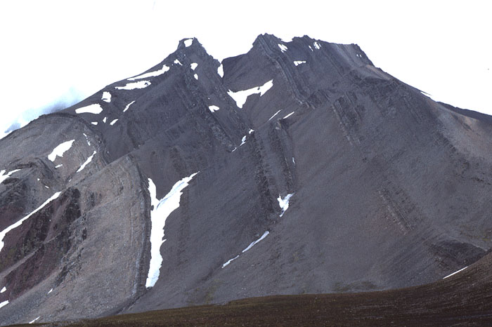
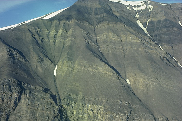
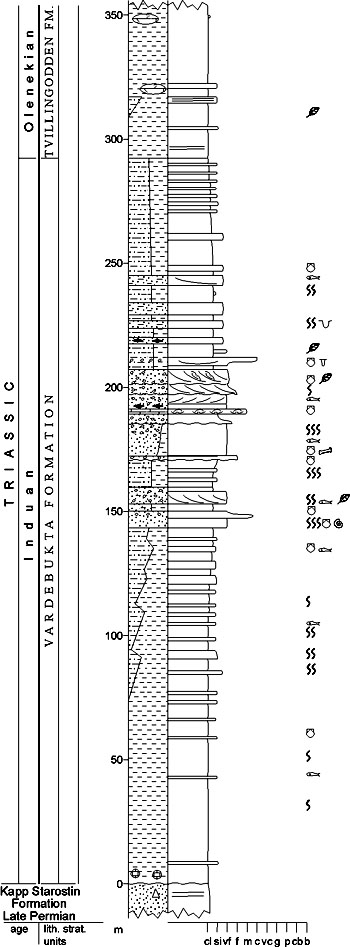
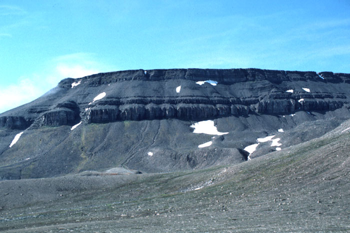
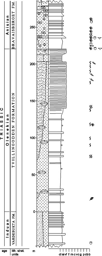
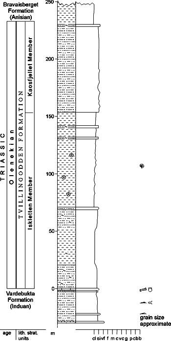
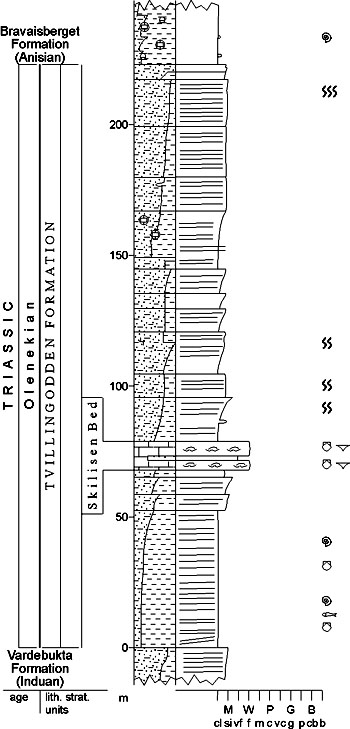
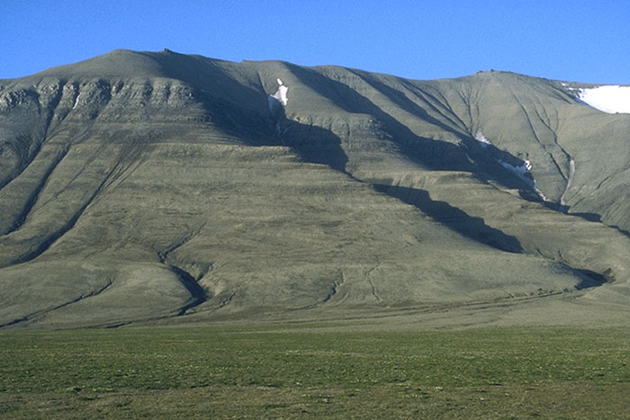
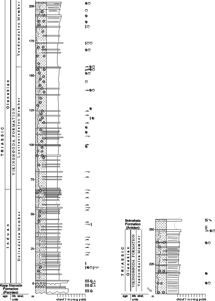
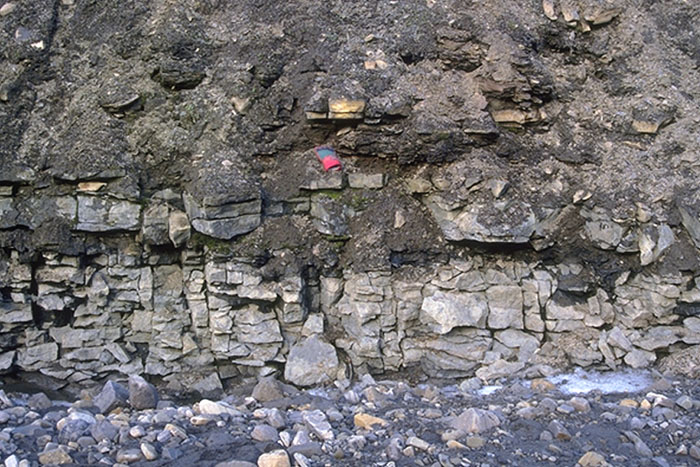
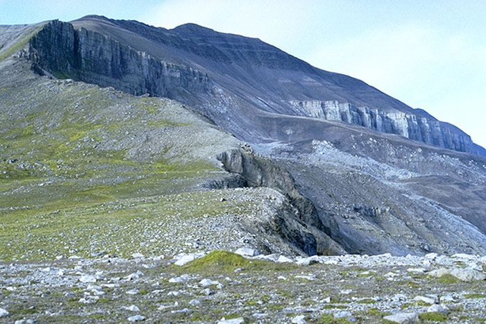
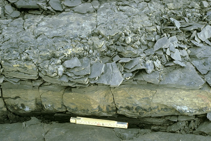
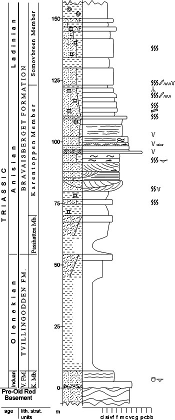
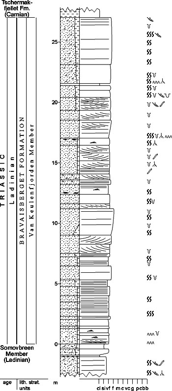
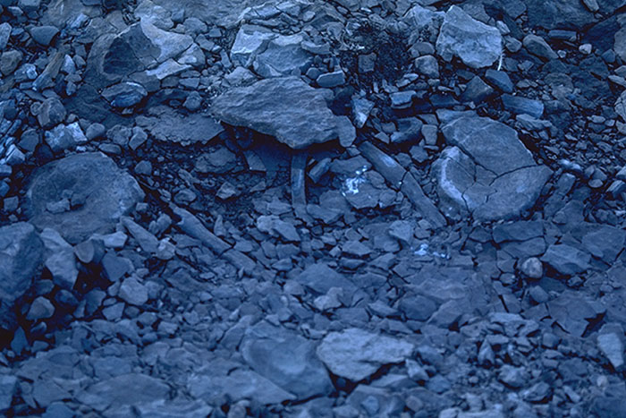
Fig. 3-14: The mountain Hyrnefjellet at Hornsund, seen from the southeast, showing the grey-coloured Sassendalen Group as it typically occurs in the Hornsund area. Vardebukta Formation: lower part of the grey succession, mostly covered by scree; Tvillingodden Formation: succeeding coarsening-upward unit with two massive sandstone beds in upper part; Bravaisberget Formation: scree-covered shale succession (Passhatten Member) and overlying sandstone succession (Somovbreen Member); Kapp Toscana Group: succession with yellow intercalations just visible to the right. For underlying, multicoloured, Palaeozoic rocks on the left side of the photograph compare Fig. 2-61. Photo: W.K. Dallmann The subdivision into ten formations reflects both lateral and vertical facies variation; there are three formations (Vardebukta, Tvillingodden and Bravaisberget formations) on western Spitsbergen, two (Vikinghøgda and Botneheia formations) in central and eastern Svalbard, one (Urd Formation) on Bjørnøya, and one (Steinkobbe Formation) only documented on the Svalis Dome in the western Barents Sea. Three formations defined in the Hammerfest Basin (Havert, Klappmyss and Kobbe formations) form the Ingøydjupet Subgroup. The group represents coastal, deltaic to shallow shelf deposits in western Spitsbergen. These coastal sediments grade eastwards and southwards into shelf mudstones. The upper part is very organic-rich and phosphatic. In the southwestern Barents Sea Shelf shallow to deep shelf sediments were deposited. VARDEBUKTA FORMATION (M-02) 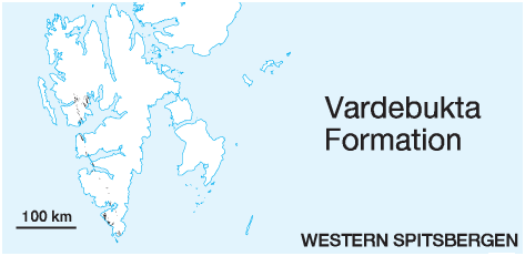 DISTRIBUTION shown on figs.: 3-06, 3-07, 3-09 STATUS OF UNIT: Formal FIRST USE OF NAME: Buchan et al. 1965 CURRENT DEFINITION: Mørk et al. 1982 SYNONYM(S) AND REFERENCE(S): None ORIGIN OF NAME: Vardebukta (transl. "The Cairn Bay"): A bay at the Festningen section, outer Isfjorden TYPE SECTION (Fig. 3-18): Stratotype: Festningen section, outer Isfjorden DEPOSITIONAL AGE: Induan DATING METHOD: Ammonoids, bivalves REFERENCE(S) FOR AGE: Tozer & Parker 1968; Korčinskaja 1982, 1986; Weitschat & Dagys 1989 OVERLYING UNIT(S): Tvillingodden Formation UNDERLYING UNIT(S): Tempelfjorden Group, locally Billefjorden Group, Gipsdalen Group or Pre-Old Red on the Sørkapp-Hornsund High SUPERIOR UNIT: Sassendalen Group OTHER USE OF NAME: None THICKNESS: 292 m in the stratotype at Isfjorden, 150-200 m in the Bellsund area, 70-80 m in western Sørkapp Land, 16 m on the Sørkapp-Hornsund High MAIN LITHOLOGIES: Shale, siltstone, sandstone LOWER BOUNDARY DEFINITION: The base is defined by grey shales resting conformably on well-cemented siliciclastic, dark grey shale of the Permian Tempelfjorden Group, or locally above older strata. See also special notes on the Kistefjellet Member. DESCRIPTION: The formation is developed in western Spitsbergen and is exposed along the Cenozoic fold-thrust belt. It is a time-equivalent of the Deltadalen Member (Vikinghøgda Formation) which represents a more distal part of the Early Triassic basin. On the Sørkapp-Hornsund High, it is only represented by the thin Kistefjellet Member which is age-correlative to the uppermost part of the unit elsewhere, unconformably overlying folded basement and tilted Lower Carboniferous sediments. In northern parts of the outcrop area, Buchan et al. (1965) defined the lower shaley Selmaneset member and the overlying Siksaken member with type sections in Oscar II Land. In southern parts, Birkenmajer (1977) defined the Urnetoppen and Wibebreen members. A regional revision of the Vardebukta Formation will probably result in the definition of additional members, so these members are considered to be informal at present. Grey shale and silty shales with thin siltstone and sandstone interbeds grade upwards into thinly to thickly bedded sandstones, which frequently contain shell fragments (Fig. 3-17). The sandstones in the middle part of the unit are cross-bedded. Above this interval sandstone beds thin and become less common towards the top of the formation. Marine fossils like bivalves, ammonoids and bioturbation are common, while fish teeth and vertebrate bones occur here and there. North of the type locality desiccation cracks are present, and southwards along the coast of western Spitsbergen the formation contains several minor coarseningupward successions. The formation represents a shallow-marine, coastal environment with prograding deltaic lobes. Offshore bars are present. Selmaneset member (M-03) STATUS OF UNIT: Informal FIRST USE OF NAME: Buchan et al. 1965 CURRENT DEFINITION: Buchan et al. 1965 SYNONYM(S) AND REFERENCE(S): None ORIGIN OF NAME: Selmaneset: A cape on the northern shore of Isfjorden, Oscar II Land TYPE SECTION: Stratotype: Selmaneset, Oscar II Land DEPOSITIONAL AGE: Induan DATING METHOD: Fossils REFERENCE(S) FOR AGE: See Vardebukta Formation OVERLYING UNIT(S): Siksaken member UNDERLYING UNIT(S): Tempelfjorden Group SUPERIOR UNIT: Vardebukta Formation OTHER USE OF NAME: None THICKNESS: 136 m in stratotype MAIN LITHOLOGIES: Shale, siltstone, sandstone LOWER BOUNDARY DEFINITION: See Vardebukta Formation DESCRIPTION: The Selmaneset member is defined by dark, often grey calcareous silty shales and shaley siltstones occurring below the resistant beds of the Siksaken member. Thin, hard calcareous siltstone interbeds are common. The unit becomes more sandy towards its top, where it contains fine-grained sandstones, silty limestones and siderite concretions. Fossils are not common, but bivalves, bone fragments and an ammonoid have been found. The deposits represent coastal to shallow marine environments. The member is described from the outer Isfjorden area. Southward along the foldbelt of western Spitsbergen it contains several coarsening-upward successions. Although the unit is well-defined in the type section, we recommend informal use of the term only in the type area until sufficient data are available for a consistent revision of the Lower Triassic member subdivision. Siksaken member (M-04) STATUS OF UNIT: Informal FIRST USE OF NAME: Buchan et al. 1965 CURRENT DEFINITION: Buchan et al. 1965 SYNONYM(S) AND REFERENCE(S): None ORIGIN OF NAME: Siksaken (transl. from "Mt. Zigzag"): A mountain group in Oscar II Land, on official maps called 'Geitene' (The Goats) TYPE SECTION: Stratotype: Geitene (Siksaken), Oscar II Land DEPOSITIONAL AGE: Induan DATING METHOD: Fossils REFERENCE(S) FOR AGE: See Vardebukta Formation OVERLYING UNIT(S): Iskletten Member (Tvillingodden Formation) UNDERLYING UNIT(S): Selmaneset member SUPERIOR UNIT: Vardebukta Formation OTHER USE OF NAME: None THICKNESS: 104 m in stratotype MAIN LITHOLOGIES: Calcareous siltstone, sandstone LOWER BOUNDARY DEFINITION: The lower boundary of the member is conformable and defined at the base of the lowest distinctly carbonate-cemented (resistant) bed above the shale-dominated part of the Vardebukta Formation. DESCRIPTION: The Siksaken member forms an easily mapable succession, consisting of alternating grey calcareous siltstones and silty limestones, passing into calcarenitic, light grey and white sandstone, hard siltstones and calcareous shales. Fossils are fairly common. The deposits represent coastal, locally exposed, to shallow marine environments. The member is described from the outer Isfjorden area. Southward along the foldbelt of western Spitsbergen it contains several coarsening-upward successions. Although the unit is well-defined in the type section, we recommend informal use of the term only in the type area until sufficient data are available for a consistent revision of the Lower Triassic member subdivision. Urnetoppen member (M-05) STATUS OF UNIT: Informal FIRST USE OF NAME: Birkenmajer 1977 CURRENT DEFINITION: Birkenmajer 1977 SYNONYM(S) AND REFERENCE(S): None ORIGIN OF NAME: Urnetoppen: A mountain north of Hornsund TYPE SECTION: Stratotype: Urnetoppen SW, Hornsund DEPOSITIONAL AGE: Induan DATING METHOD: Fossils, stratigraphic relationships REFERENCE(S) FOR AGE: See Vardebukta Formation; Birkenmajer 1977 OVERLYING UNIT(S): Wibebreen Member UNDERLYING UNIT(S): Tempelfjorden Group SUPERIOR UNIT: Vardebukta Formation OTHER USE OF NAME: None THICKNESS: 22.5 m in stratotype MAIN LITHOLOGIES: Shale, siltstone, sandstone LOWER BOUNDARY DEFINITION: See Vardebukta Formation DESCRIPTION: The Urnetoppen member consists predominantly of grey-greenish, grey to black shale with subordinate siltstones and fine-grained sandstone intercalations. In some sections, siltstones and sandstones may apparently partly or entirely replace the shale component of the member. Sphero-siderite nodules or lenses occur locally within the shale. Glauconitic sandstone and siltstone may appear at the base of the member. Red-weathering, ferrigenous (sideritic-pyritic) limestone, sandstone and shale, as well as light (yellowish, whitish) cross-bedded or mega-rippled thin sandstones usually occur at the top of the member. The member was deposited in shallow marine environments. The unit is defined in the Hornsund area. Along the coast of western Spitsbergen several coarsening-upward successions occur. Although the unit is well defined in the type section, we recommend informal use of the term until sufficient data are available for a consistent revision of the Lower Triassic member subdivision. Wibebreen member (M-06) STATUS OF UNIT: Informal FIRST USE OF NAME: Birkenmajer 1977 CURRENT DEFINITION: Birkenmajer 1977, although revised here to not include deposits of the Kistefjellet Member (M-07) on the Sørkapp-Hornsund High. SYNONYM(S) AND REFERENCE(S): None ORIGIN OF NAME: Wibebreen: A glacier north of Hornsund TYPE SECTION: Stratotype: Urnetoppen SW, Hornsund DEPOSITIONAL AGE: Induan DATING METHOD: Fossils and stratigraphic relationships REFERENCE(S) FOR AGE: See Vardebukta Formation; Birkenmajer 1977 OVERLYING UNIT(S): Tvillingodden Formation UNDERLYING UNIT(S): Urnetoppen member SUPERIOR UNIT: Vardebukta Formation OTHER USE OF NAME: None THICKNESS: 47 m in stratotype MAIN LITHOLOGIES: Shale, siltstone, sandstone LOWER BOUNDARY DEFINITION: The base of the member is defined by the boundary between an underlying bivalve-rich bed attributed to conglomeratic equivalents of the "Brevassfjellet Myalina Bed", and the overlying shales, siltstones and sandstones which constitute the upper part of the Vardebukta Formation. DESCRIPTION: The Wibebreen member occurs in the Sørkapp-Hornsund area, off the Sørkapp-Hornsund High. It correlates in age with the Kistefjellet Member on the high. The unit consists predominantly of two rock types, viz. (1) grey to black shale to marly shale, and (2) grey, greenishgrey, platy siltstone and fine-grained sandstone. The shales predominate in the uppermost, and often also the bottom parts of the member. Siltstone-sandstone horizons may appear as thicker, even cliff-forming bands in the middle part of the unit. Well-developed lamination, small-scale cross-bedding and ripple-marks/lamination are characteristic. Subordinate lithologies are ferruginous marls, blue, rusty-brown-weathering, silty limestone bands and siderite concretions. In some sections the member is entirely represented by shale. The member was deposited in shallow marine environments. Although the unit is well-defined in the type section we recommend informal status until sufficient data are available for a consistent revision of the Lower Triassic member subdivision. Kistefjellet Member (M-07) STATUS OF UNIT: Formal FIRST USE OF NAME: Mørk et al. 1982 CURRENT DEFINITION: Pčelina 1983 SYNONYM(S) AND REFERENCE(S): Kistefjellet "Formation": Pčelina 1983 ORIGIN OF NAME: Kistefjellet (transl. "The Coffin Mountain"): A mountain near the southern tip of Sørkapp Land TYPE SECTION: Stratotype: Kistefjellet, Sørkapp Land DEPOSITIONAL AGE: Late Induan DATING METHOD: Brachiopods, stratigraphic relationships REFERENCE(S) FOR AGE: Korčinskaja 1982; Birkenmajer 1977; Pčelina 1983; Nakrem & Mørk 1991 OVERLYING UNIT(S): Tvillingodden Formation UNDERLYING UNIT(S): Pre-Old Red, in places possibly Upper Palaeozoic sediments of unknown stratigraphic affiliation SUPERIOR UNIT: Vardebukta Formation OTHER USE OF NAME: Kistefjellet "Formation": Mørk et al. 1982. According to Mørk et al.'s definition, the Kistefjellet Formation includes the Olenekian part of the Sassendalen Group on the Sørkapp-Hornsund High. This definition is not supported, and the Olenekian part is assigned to the Tvillingodden Formation. THICKNESS: 16 m in stratotype MAIN LITHOLOGIES: Sandstone, conglomerate LOWER BOUNDARY DEFINITION: The base of the member is defined by a basal conglomerate or sandstones unconformably overlying folded, Pre-Old Red on the Sørkapp-Hornsund High (see Brevassfjellet Bed, M-08; Figs. 3-19, 3-20). Locally, a thin horizon of Upper Palaeozoic calcareous rocks may occur below. DESCRIPTION: The Kistefjellet Member consists of a basal polymict conglomerate (Brevassfjellet Bed, M-08; Fig. 3-20) of local provenance. The conglomerate is overlain by silty sandstones which contain brachiopods in their lower parts. The member was deposited in shallow marine environments, starting with a transgressive bed. Brevassfjellet Bed (M-08) STATUS OF UNIT: Formal FIRST USE OF NAME: Birkenmajer 1977 CURRENT DEFINITION: Mørk et al. 1982 SYNONYM(S) AND REFERENCE(S): None ORIGIN OF NAME: Brevassfjellet (transl. "The Glacial Water Mountain"): A mountain in western Sørkapp Land TYPE SECTION: Stratotype: Kistefjellet, Sørkapp Land DEPOSITIONAL AGE: Late Induan DATING METHOD: Bivalves, stratigraphic relationships REFERENCE(S) FOR AGE: Mørk et al. 1982 OVERLYING UNIT(S): Unnamed UNDERLYING UNIT(S): Pre-Old Red, in places possibly Upper Palaeozoic sediments of unknown stratigraphic affiliation SUPERIOR UNIT: Kistefjellet Member OTHER USE OF NAME: "Brevassfjellet Myalina Bed": Birkenmajer (1977). The name was used for both the basal conglomerate directly resting on the basement on the Sørkapp-Hornsund High, and for the bivalve-rich beds in the middle part of the Vardebukta Formation east of the high. The name is now restricted to the conglomerates on the Sørkapp-Hornsund High (Worsley & Mørk 1978). THICKNESS: <2 m MAIN LITHOLOGIES: Conglomerate LOWER BOUNDARY DEFINITION: See Kistefjellet Member DESCRIPTION: The Brevassfjellet Bed consists of a polymict conglomerate of local provenance. It contains clasts of basement and Upper Palaeozoic (possibly Permian) cherts and limestones. The bivalve Promyalina sp. is locally common (Karentoppen). At Lidfjellet red-weathering, crumbled calcareous rocks may be included in the Brevassfjellet Bed, or may represent remains of an Upper Palaeozoic unit between the basement and the Triassic succession. The bed initiates the Triassic marine sedimentation in its area. Back to top TVILLINGODDEN FORMATION (M-09) 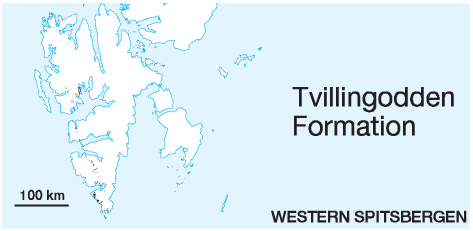 DISTRIBUTION shown on figs.: 3-06, 3-07, 3-09 STATUS OF UNIT: Formal FIRST USE OF NAME: Mørk et al. 1982 CURRENT DEFINITION: Mørk et al. 1982 SYNONYM(S) AND REFERENCE(S): "Pitnerodden Formation": Pčelina 1983; "Sticky Keep Formation", western outcrop area: Buchan et al. 1965 ORIGIN OF NAME: Tvillingodden (transl. "The Twin Cape"): Actually 'Tvillingoddane' (plural), or 'Austre' (Eastern) and 'Vestre (Western) Tvillingodden': two small peninsulas at the Festningen section, outer Isfjorden, where the western one forms the type section. TYPE SECTION (Fig. 3-21): Stratotype: Festningen section, outer Isfjorden DEPOSITIONAL AGE: Olenekian DATING METHOD: Ammonoids, brachiopods REFERENCE(S) FOR AGE: Tozer & Parker 1968; Korčinskaja 1982; Weitschat & Dagys 1989 OVERLYING UNIT(S): Bravaisberget Formation UNDERLYING UNIT(S): Vardebukta Formation SUPERIOR UNIT: Sassendalen Group OTHER USE OF NAME: "Tvillingodden Formation" (Pčelina 1980): The unit name as used by Pčelina is replaced by Tverrbekken member (M-44) THICKNESS: 200-250 m in the Isfjorden - Bellsund area (220 m in stratotype), 70-110 m in western Sørkapp Land, ca. 20-30 m on the Sørkapp-Hornsund High MAIN LITHOLOGIES: Shale, siltstone, sandstone LOWER BOUNDARY DEFINITION: The base is defined where thinly laminated, unbioturbated shale overlies the distinctly more silty shale of the Vardebukta Formation. DESCRIPTION: The formation is developed in western Spitsbergen and exposed along the Cenozoic fold-thrust belt. It is a time-equivalent of the Lusitaniadalen and Vendomdalen members (Vikinghøgda Formation) which represent more central facies developments in the Early Triassic basin. In northern parts of the outcrop area, Buchan et al. (1965) distinguished the Iskletten and Kaosfjellet members with type sections in Oscar II Land. The formation consists of dark grey, laminated shales coarsening upwards to laminated siltstones and sandstones. South of the type area, the formation shows several (up to four) coarsening-upward units. Bioturbation (e.g. Rhizocorallium) is common or abundant in the upper parts of the individual coarsening-upward units. A pronounced fossiliferous limestone bed (the Skilisen Bed) occurs in the southern part of western Spitsbergen. At the type locality a fossiliferous bed occurs at the top of the formation. Except for these limestone beds, macrofossils (bivalves, brachiopods, ammonoids) are sparse, though they occur throughout the formation. The entire formation is of marine origin, deposited in moderately deep to shallow shelf environments, with the thicker limestone units representing bar environments. Iskletten Member (M-10) STATUS OF UNIT: Formal FIRST USE OF NAME: Buchan et al. 1965 CURRENT DEFINITION: Buchan et al. 1965 SYNONYM(S) AND REFERENCE(S): None ORIGIN OF NAME: Iskletten (transl. "The Ice Bluff "): A mountain in Oscar II Land TYPE SECTION (Fig. 3-22): Stratotype: Iskletten, Oscar II Land DEPOSITIONAL AGE: Olenekian DATING METHOD: Ammonoids and bivalves, stratigraphic correlations REFERENCE(S) FOR AGE: See Tvillingodden Formation OVERLYING UNIT(S): Kaosfjellet Member UNDERLYING UNIT(S): Vardebukta Formation SUPERIOR UNIT: Tvillingodden Formation OTHER USE OF NAME: None THICKNESS: 154 m in stratotype MAIN LITHOLOGIES: Shale, calcareous siltstone LOWER BOUNDARY DEFINITION: See Tvillingodden Formation DESCRIPTION: The member forms the lower part of the Tvillingodden Formation and consists of interbedded dark grey, often calcareous silty shale, and grey to grey-green, flaggy and laminated, calcareous shaley siltstone. Grey septarian limestone concretions are common – especially in the upper part, and hard yellow-weathering thin calcareous siltstone interbeds are also common. Fossils are not particularly abundant, but ammonoids and bivalves do occur, especially in the limestone concretions. The unit is easily recognised between the cliff-forming members below and above. Lithologies are fairly uniform. The member was deposited in shallow marine environments. The unit is recognised in the outer Isfjorden area and in Oscar II Land. Southward along the Cenozoic fold-thrust belt several coarsening-upward units occur. The unit is well defined in the type area and we recommend use of the name only in this region until sufficient data are available for a consistent revision of the Lower Triassic member subdivision. The member is approximately time-equivalent with the Lusitaniadalen Member in central Spitsbergen and eastern Svalbard. Kaosfjellet Member (M-11) STATUS OF UNIT: Formal FIRST USE OF NAME: Buchan et al. 1965 CURRENT DEFINITION: Buchan et al. 1965 SYNONYM(S) AND REFERENCE(S): None ORIGIN OF NAME: Kaosfjellet (transl. "The Chaos Mountain"): A tectonized mountain in Oscar II Land TYPE SECTION (Fig. 3-22): Stratotype: Iskletten, Oscar II Land DEPOSITIONAL AGE: Olenekian DATING METHOD: Fossils, stratigraphic correlations REFERENCE(S) FOR AGE: See Tvillingodden Formation OVERLYING UNIT(S): Bravaisberget Formation UNDERLYING UNIT(S): Iskletten Member SUPERIOR UNIT: Tvillingodden Formation OTHER USE OF NAME: None THICKNESS: 76 m in stratotype MAIN LITHOLOGIES: Siltstone LOWER BOUNDARY DEFINITION: The lower boundary of the member is defined at the abrupt onset of continuous siltstones above shales, accompanied by a distinct change in colour. DESCRIPTION: The Kaosfjellet Member forms a distinctive cliff, consisting of yellow-brown weathering, laminated shaley siltstones, thinly alternating with fragmented, hard, thin grey, slightly calcareous, orange and red-brown weathering siltstones. The upper and lower contacts are marked by abrupt changes in colour, lithology and resistance. The member was deposited in shallow marine prodelta environments. The unit is defined in the outer Isfjorden area and Oscar II Land, and is only recognised in the thicker sections of the western outcrop belt north of Wedel Jarlsberg Land. Southward along the Cenozoic fold-thrust belt several coarsening upward units occur. The unit is well defined in the type area and we recommend use of the name only in this region until sufficient data are available for a consistent revision of the Lower Triassic member subdivision. The member is approximately time-equivalent with the Vendomdalen Member of central Spitsbergen and eastern Svalbard. Skilisen Bed (M-12) STATUS OF UNIT: Formal FIRST USE OF NAME: Birkenmajer 1977 CURRENT DEFINITION: Mørk et al. 1982. The unit was introduced by Birkenmajer (1977) and applied by Worsley & Mørk (1978) with reference to sections at Sørkapp Land, but subsequently redefined by Mørk et al. (1982) according to its first description by Lundgren (1887; "Retziakalk"). SYNONYM(S) AND REFERENCE(S): "Retziakalk" ("Retzia limestone"): Lundgren 1887 ORIGIN OF NAME: Skilisen (transl. "The Divide Glacier"): A glacier in Torell Land TYPE SECTION (Fig. 3-23): Stratotype: Bravaisberget, Van Keulenfjorden DEPOSITIONAL AGE: Olenekian DATING METHOD: Brachiopods, stratigraphic correlations REFERENCE(S) FOR AGE: See Tvillingodden Formation SUPERIOR UNIT: Tvillingodden Formation OTHER USE OF NAME: None THICKNESS: <18 m, 11 m in stratotype MAIN LITHOLOGIES: Sandy limestone LOWER BOUNDARY DEFINITION: The lower boundary is defined at the base of a biosparitic limestone in the middle part of the Tvillingodden Formation, ca. 70 m above the formational base in the type section. DESCRIPTION: The unit consists of sandy, biosparitic limestone rich in brachiopods and bivalves. It is only a few metres thick in the type locality, but it is developed as an 18 m thick crinoidal biosparite in central Sørkapp Land. The unit represents open marine bank deposits. Back to top VIKINGHØGDA FORMATION (M-13) 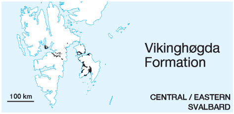 DISTRIBUTION shown on figs.: 3-08, 3-09, 3-10, 3-12 STATUS OF UNIT: Formal FIRST USE OF NAME: Mørk et al. 1999 CURRENT DEFINITION: Mørk et al. 1999 SYNONYM(S) AND REFERENCE(S): "Vardebukta" and "Sticky Keep" formations in central and eastern Svalbard: Buchan et al. 1965; Deltadalen and "Sticky Keep" members: Mørk et al. 1982; "Vardebukta" and "Wichebukta formations" in central and eastern Svalbard: Pčelina 1983; Lower part of "Barentsøya Formation": Lock et al. 1978 ORIGIN OF NAME: Vikinghøgda (transl. "The Viking Hill"): A mountain south of Sassendalen, eastern Nordenskiöld Land TYPE SECTION (Fig. 3-25): Stratotype: Deltadalen - Vikinghøgda, eastern Nordenskiöld Land DEPOSITIONAL AGE: Induan - Olenekian DATING METHOD: Ammonoids, bivalves, palynomorphs REFERENCE(S) FOR AGE: Tozer & Parker 1968; Korčinskaja 1975, 1986; Weitschat & Dagys 1989; Mørk et al. 1999 OVERLYING UNIT(S): Botneheia Formation UNDERLYING UNIT(S): Kapp Starostin Formation SUPERIOR UNIT: Sassendalen Group OTHER USE OF NAME: None THICKNESS: 250 m in stratotype, central Spitsbergen 200-220 m in central eastern Spitsbergen MAIN LITHOLOGIES: Shale, siltstone LOWER BOUNDARY DEFINITION: The formational base is defined where soft weathering sandstones or siltstones rest with a sharp boundary on glauconitic cherty sandstones of the Kapp Starostin Formation (Upper Permian) (Fig. 3-26). DESCRIPTION: The formation consists of grey shales and silty shales with subordinate siltstones and carbonate beds. Septarian nodules are abundant at several levels. The former twofold subdivision of these deposits has recently been revised by a threefold subdivision which reflects better the nature of the stratigraphic sections (Mørk et al. 1999). These three units are the Deltadalen Member (unchanged definition), Lusitaniadalen Member and Vendomdalen Member, the two latter replacing the "Sticky Keep Member". The lower part of the formation (Deltadalen Member) is shaley and sandy, the middle part (Lusitaniadalen Member) consists of mudstones and siltstone beds, while the upper part (Vendomdalen Member) is dominated by dark grey mudstone with dolomite beds. The formation represents a series of stacked transgressive-regressive successions (Fig. 3-24), each member being initiated by a regionally significant transgression (Mørk et al. 1999; Egorov & Mørk, in press), and deposited in moderately deep marine shelf environments. The formation is time-equivalent with the Vardebukta and Tvillingodden formations in western Spitsbergen. Deltadalen Member (M-14) STATUS OF UNIT: Formal FIRST USE OF NAME: Mørk et al. 1982 CURRENT DEFINITION: Mørk et al. 1999 SYNONYM(S) AND REFERENCE(S): Vardebukta Formation: Buchan et al. 1965. The name 'Vardebukta Formation' is now restricted to the western outcrop belt. ORIGIN OF NAME: Deltadalen (transl. "The Delta Valley"): A tributary valley of Sassendalen, eastern Nordenskiöld Land TYPE SECTION (Fig. 3-25): Stratotype: Deltadalen, Nordenskiöld Land DEPOSITIONAL AGE: Induan DATING METHOD: Ammonoids, palynomorphs REFERENCE(S) FOR AGE: Korčinskaja 1982; Mørk et al. 1999 OVERLYING UNIT(S): Lusitaniadalen Member UNDERLYING UNIT(S): Kapp Starostin Formation SUPERIOR UNIT: Vikinghøgda Formation OTHER USE OF NAME: None THICKNESS: 68 m in stratotype MAIN LITHOLOGIES: Shale, sandstone LOWER BOUNDARY DEFINITION: See Tvillingodden Formation DESCRIPTION: The Deltadalen Member starts with silty shale and thin to medium thick beds of sandstone. The remaining part of the member consists of greenish-grey, silty shale, siltstone and sandstone. The sandstone beds show hummocky cross-stratification, wave ripples or planar lamination, which often fine upwards. Carbonate concretions and marine fossils are present. The rock weathers to a grey or greenish-grey colour. The member was deposited in shallow to moderately deep shelf environments. The unit's top has recently been moved to a somewhat lower position (Mørk et al. 1999) than that envisaged by (Mørk et al. 1982). Findings of Smithian (lower Olenekian) ammonoids in what is now the lower part of the overlying Lusitaniadalen Member, have improved correlations leading to the exclusion of these beds from the Deltadalen Member. The member is time-equivalent to the Vardebukta Formation in western Spitsbergen. Lusitaniadalen Member (M-15) STATUS OF UNIT: Formal FIRST USE OF NAME: Mørk et al. 1999 CURRENT DEFINITION: Mørk et al. 1999 SYNONYM(S) AND REFERENCE(S): The member corresponds approximately to the lower part of the former "Sticky Keep Formation" (Buchan et al. 1965) or "Sticky Keep Member" (Mørk et al. 1982) ORIGIN OF NAME: Lusitaniadalen: A tributary valley of Sassendalen, eastern Nordenskiöld Land TYPE SECTION (Fig. 3-25): Stratotype: Deltadalen - Vikinghøgda, Nordenskiöld Land DEPOSITIONAL AGE: Smithian (Early Olenekian) DATING METHOD: Ammonoids, bivalves, palynology REFERENCE(S) FOR AGE: Weitschat & Lehmann 1978; Korčinskaja 1982; Mørk et al. 1999 OVERLYING UNIT(S): Vendomdalen Member UNDERLYING UNIT(S): Deltadalen Member SUPERIOR UNIT: Vikinghøgda Formation OTHER USE OF NAME: None THICKNESS: 88 m in stratotype MAIN LITHOLOGIES: Shale, sandstone LOWER BOUNDARY DEFINITION: The base is defined by the change from silty shale and sandstone beds (Deltadalen Member) to laminated dark grey shales. The boundary is often marked by a change in the surface slope angle. DESCRIPTION: The Lusitaniadalen Member consists of dark grey shales with thin to medium thick beds of yellowweathering, calcareous siltstones. Limestone nodules (0.1-1 m) are abundant and often occur in well-defined horizons. Siltstone beds are common and are between a few millimetres and several centimetres thick. The base and lower parts of the unit are well-exposed in Deltadalen (the valley between Sticky Keep and Vikinghøgda). The member is an approximate time-equivalent of the Iskletten Member farther west. It was deposited in moderately deep shelf environments. Vendomdalen Member (M-16) STATUS OF UNIT: Formal FIRST USE OF NAME: Mørk et al. 1999 CURRENT DEFINITION: Mørk et al. 1999 SYNONYM(S) AND REFERENCE(S): The member corresponds to the upper part of the former "Sticky Keep Formation" (Buchan et al. 1965) or "Sticky Keep Member" (Mørk et al. 1982) ORIGIN OF NAME: Vendomdalen: (transl. "The Turn-Around Valley") A tributary valley of Sassendalen, western Sabine Land TYPE SECTION (Fig. 3-25): Stratotype: Vikinghøgda, Nordenskiöld Land DEPOSITIONAL AGE: Spathian (Late Olenekian) DATING METHOD: Ammonoids, bivalves, palynology REFERENCE(S) FOR AGE: Weitschat & Lehmann 1978; Korčinskaja 1982; Mørk et al. 1999 OVERLYING UNIT(S): Botneheia Formation UNDERLYING UNIT(S): Lusitaniadalen Member SUPERIOR UNIT: Vikinghøgda Formation OTHER USE OF NAME: None THICKNESS: 94 m in stratotype MAIN LITHOLOGIES: Mudstone LOWER BOUNDARY DEFINITION: The base is defined by the change from silty shale with siltstone beds (Lusitaniadalen Member) to the dark grey, comparatively uniform mudstone lithology of the Vendomdalen Member. DESCRIPTION: The main lithology is dark grey mudstone with medium to thick beds of yellow weathering dolomite. Large septarian nodules occur as horizons in the lower part of the member, while small carbonate nodules occur throughout the member. Ammonoids and bivalves are abundant. On top of the member a thick silty dolomite bed with ammonoid imprints frequently occurs. The member is a time-equivalent of the Kaosfjellet Member farther west. The member was deposited in moderately deep to deep shelf environments. Back to top URD FORMATION (M-17) 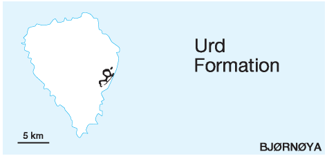 DISTRIBUTION shown on fig. 2-05 STATUS OF UNIT: Formal FIRST USE OF NAME: Krasil'ščikov & Livšic 1974 CURRENT DEFINITION: Mørk et al. 1982 SYNONYM(S) AND REFERENCE(S): "Vardebukta" and "Wichebukta formations" on Bjørnøya: Pčelina 1983 ORIGIN OF NAME: Urd (an Old Norse goddess): One of the mountain summits of Miseryfjellet, Bjørnøya TYPE SECTION (Fig. 3-28): Stratotype: Urd, Miseryfjellet (Bjørnøya) DEPOSITIONAL AGE: Early to ?Middle Triassic DATING METHOD: Ammonoids, palynology REFERENCE(S) FOR AGE: Pčelina 1972; Mørk et al. 1990 OVERLYING UNIT(S): Skuld Formation UNDERLYING UNIT(S): Miseryfjellet Formation SUPERIOR UNIT: Sassendalen Group OTHER USE OF NAME: None THICKNESS: 65 m in stratotype MAIN LITHOLOGIES: Sandstone, shale LOWER BOUNDARY DEFINITION: The base is defined by a sharp boundary with a slight angular unconformity between underlying limestones of the Miseryfjellet Formation and the Triassic sandstone. DESCRIPTION: The lower part of the Urd Formation (22 m) consists of sandstone and siltstones changing upwards into silty shale. The upper 40 m consists of silty shale with thin siltstone laminae and yellow weathering, thin siltstone beds. Poorly preserved ammonoids and bivalves occur in this section. Close to the top several yellowish weathering, dolomitic siltstone beds occur. The top is formed by a 20 cm thick conglomerate bed with phosphatic nodules (Verdande Bed). The formation was deposited in shallow marine shelf environments. Thorough descriptions of the formation are provided by Pčelina (1972) and Mørk et al. (1990) (Fig. 3-27). Verdande Bed (M-18) STATUS OF UNIT: Formal FIRST USE OF NAME: Mørk et al. 1982 CURRENT DEFINITION: Mørk et al. 1982 SYNONYM(S) AND REFERENCE(S): None ORIGIN OF NAME: Verdande (an Old Norse Goddess): One of the mountain summits of Miseryfjellet, Bjørnøya TYPE SECTION (Fig. 3-28): Stratotype: Urd, Miseryfjellet (Bjørnøya) DEPOSITIONAL AGE: ?Late Middle Triassic DATING METHOD: Indirect, stratigraphic relationships REFERENCE(S) FOR AGE: Pčelina 1972; Mørk et al. 1990 OVERLYING UNIT(S): Skuld Formation SUPERIOR UNIT: Urd Formation OTHER USE OF NAME: None THICKNESS: 0.2 m MAIN LITHOLOGIES: Phosphate nodule conglomerate LOWER BOUNDARY DEFINITION: The lower boundary is defined by the sharp onset of the nodular lithology of this bed above siltstones. DESCRIPTION: The Verdande Bed is a remanié conglomerate consisting of phosphate nodules which measure a few centimetres in diameter. The conglomerate rests on dolomitic siltstones. There is a pronounced break in the surface slope angle at the bed, which forms a small ledge. The nodules often have irregular shapes and weather with a bluish-grey colour. The bed is interpreted as representing the winnowed remains of an originally thicker Middle Triassic unit (Pčelina 1972; Mørk et al. 1990). Back to top BRAVAISBERGET FORMATION (M-19)  DISTRIBUTION shown on figs.: 3-06, 3-07, 3-09 STATUS OF UNIT: Formal FIRST USE OF NAME: Mørk et al. 1982 CURRENT DEFINITION: Mørk et al. 1982 SYNONYM(S) AND REFERENCE(S): "Botneheia Formation": Buchan et al. (1965). The name 'Botneheia Formation' is now only referred to time-equivalent deposits in central Spitsbergen and eastern Svalbard. ORIGIN OF NAME: Bravaisberget: A mountain in Nathorst Land, Van Keulenfjorden TYPE SECTION (Fig. 3-31): Stratotype: Bravaisberget, Van Keulenfjorden DEPOSITIONAL AGE: Middle Triassic DATING METHOD: Ammonoids, bivalves REFERENCE(S) FOR AGE: Tozer & Parker 1968; Korčinskaja 1982; Weitschat & Lehmann 1983 OVERLYING UNIT(S): Tschermakfjellet Formation UNDERLYING UNIT(S): Tvillingodden Formation SUPERIOR UNIT: Sassendalen Group OTHER USE OF NAME: None THICKNESS: 200-250 m in the outer Isfjorden - Bellsund area (209 m in stratotype), ca. 110 m in western Sørkapp Land, ca. 70-80 m on the Sørkapp Hornsund High MAIN LITHOLOGIES: Mudstone, siltstone, sandstone LOWER BOUNDARY DEFINITION: The formational base is defined by soft, dark mudstone resting conformably on top of the cliff-forming siltstones and sandstones of the underlying formation. DESCRIPTION: The Bravaisberget Formation forms a major coarsening-upward succession, where the basal mudstones grade into siltstones and sandstones. Small phosphate nodules occur abundantly throughout the formation. Southward along the Cenozoic fold-thrust belt the siltstones and sandstones show abundant calcite and dolomite cementation which results in a yellow weathering colour. Oolite horizons occur in the northern areas. Ammonoid, bivalve and brachiopod faunas are common. Trace fossils occur in upward increasing abundance. The unit is rich in organic material (TOC 1-7 %) and represents, together with the time-equivalent (although generally more mudstone-dominated) Botneheia Formation, the most promising hydrocarbon source rock potential of Svalbard. Phosphate nodules occur abundantly throughout the formation (Fig. 3-30). The formation is subdivided into four members: The lower Passhatten Member is shale dominated, while the overlying Somovbreen Member consists of calcareous siltstones (Fig. 3-29). The Van Keulenfjorden Member caps the succession with a silicified calcareous sandstone. The Karentoppen Member in southwestern Spitsbergen represents intercalated deltaic to fluvial sandstones. The Bravaisberget Formation is interpreted as a deltaic influenced, regressive unit, with several superimposed lowerorder transgressive-regressive units representing prograding delta front mudstones and siltstones (Mørk et al. 1989). Passhatten Member (M-20) STATUS OF UNIT: Formal FIRST USE OF NAME: Birkenmajer 1977 CURRENT DEFINITION: Mørk et al. 1982 SYNONYM(S) AND REFERENCE(S): None ORIGIN OF NAME: Passhatten (transl. "The Pass Hat"): A mountain in Wedel Jarlsberg Land TYPE SECTION (Figs. 3-31, 3-32): Stratotype: Treskelen, Hornsund Hypostratotype: Bravaisberget, Van Keulenfjorden. The type section was first defined at Passhatten by Birkenmajer (1977), according to a description by Różycki (1959). The redefined type sections reflect easier accessible and meanwhile better described sections that also account for the lateral variation of the unit. DEPOSITIONAL AGE: Anisian DATING METHOD: Ammonoids REFERENCE(S) FOR AGE: Tozer & Parker 1968; Korčinskaja 1982 OVERLYING UNIT(S): Somovbreen and Karentoppen members UNDERLYING UNIT(S): Tvillingodden Formation SUPERIOR UNIT: Bravaisberget Formation OTHER USE OF NAME: None THICKNESS: 53 m in the stratotype, 76 m in the hypostratotype MAIN LITHOLOGIES: Mudstone, siltstone LOWER BOUNDARY DEFINITION: See Bravaisberget Formation DESCRIPTION: The Passhatten Member forms the lower, fine-grained part of the Bravaisberget Formation. The main lithology is dark grey, soft mudstone. Siltstone and silty limestone beds, often with phosphate nodular conglomerates, are abundant. These siltstone beds increase in thickness (dm to m size) and abundance towards the upper boundary, usually with the Somovbreen Member. The unit is poor in fossils. The member was deposited in open marine shelf environments. Karentoppen Member (M-21) STATUS OF UNIT: Formal FIRST USE OF NAME: Mørk et al. 1982 CURRENT DEFINITION: Mørk et al. 1982 SYNONYM(S) AND REFERENCE(S): None ORIGIN OF NAME: Karentoppen: A mountain in western Sørkapp Land TYPE SECTION (Fig. 3-34): Stratotype: Karentoppen, Sørkapp Land DEPOSITIONAL AGE: Middle Triassic DATING METHOD: Indirect, stratigraphic relationships REFERENCE(S) FOR AGE: Mørk et al. 1982 OVERLYING UNIT(S): Somovbreen Member UNDERLYING UNIT(S): Passhatten Member SUPERIOR UNIT: Bravaisberget Formation OTHER USE OF NAME: None THICKNESS: 43 m in the stratotype MAIN LITHOLOGIES: Sandstone, conglomerate LOWER BOUNDARY DEFINITION: The bioturbated sandstones of the Karentoppen Member rest with a sharp contact on the phosphatic shales of the Passhatten Member. DESCRIPTION: The Karentoppen Member is restricted to western Sørkapp Land and forms a wedge between the Passhatten and Somovbreen members. It consists of crossbedded sandstones (Fig. 3-33) grading upward into the Somovbreen Member. It is characterised by an upward-fining, cross- to planar laminated sandstone succession with subordinate conglomerate beds. Herringbone cross-bedding occurs in the lower part of the unit. Trace fossils change gradually from being high-energy protective burrows in the lower part to the typical marine ichnocoenosis of the Somovbreen Member uppermost. The member represents deltaic distributary sandstones. Somovbreen Member (M-22) STATUS OF UNIT: Formal FIRST USE OF NAME: Birkenmajer 1977 CURRENT DEFINITION: Mørk et al. 1982; modified here to exclude the uppermost sandstone unit (Van Keulenfjorden Member) SYNONYM(S) AND REFERENCE(S): None ORIGIN OF NAME: Somovbreen: A glacier in Torell Land TYPE SECTION (Figs. 3-31, 3-32): Stratotype: Treskelen, Hornsund. Hypostratotype: Bravaisberget, Van Keulenfjorden. The type section was first defined at Passhatten by Birkenmajer (1977), according to a description by Różycki (1959). The redefined type sections reflect easier accessible and meanwhile better described sections that also account for the lateral variation of the unit. DEPOSITIONAL AGE: ?Anisian - Ladinian DATING METHOD: Ammonoids, bivalves REFERENCE(S) FOR AGE: Tozer & Parker 1968; Korčinskaja 1982 OVERLYING UNIT(S): Van Keulenfjorden Member UNDERLYING UNIT(S): Passhatten and Karentoppen members SUPERIOR UNIT: Bravaisberget Formation OTHER USE OF NAME: None THICKNESS: 40 m in the stratotype, 89 m in the hypostratotype MAIN LITHOLOGIES: Siltstone, sandstone LOWER BOUNDARY DEFINITION: The lower boundary coincides with the base of the cliff-forming siltstones and sandstones forming the upper part of the Bravaisberget Formation, overlying the dark mudstone-dominated lithologies of the Passhatten Member. DESCRIPTION: The Somovbreen Member comprises the upper siltstone-dominated part of the Bravaisberget Formation, except for the uppermost, massive sandstone. There is a gradual transition from the underlying members. The siltstones contain abundant calcite and dolomite cement. They are strongly bioturbated, and often show a succession of trace fossils reflecting upwards increasing energy levels. Oolitic beds in the northern areas are provisionally included in the member. The unit contains ammonoids, bivalves and reptile bones. The member was mainly deposited in prodelta environments. Van Keulenfjorden Member (M-23) STATUS OF UNIT: Formal FIRST USE OF NAME: Pčelina 1983 CURRENT DEFINITION: Pčelina 1983 SYNONYM(S) AND REFERENCE(S): "Fossesandstein": Hoel & Orvin 1937 (upper part of Van Keulenfjorden Member) ORIGIN OF NAME: Van Keulenfjorden: A major fiord in western Spitsbergen TYPE SECTION (Fig. 3-35): Stratotype: Bravaisodden, Van Keulenfjorden DEPOSITIONAL AGE: Ladinian DATING METHOD: Fossils, stratigraphic correlation REFERENCE(S) FOR AGE: Pčelina 1983 OVERLYING UNIT(S): Tschermakfjellet Formation UNDERLYING UNIT(S): Somovbreen Member SUPERIOR UNIT: Bravaisberget Formation OTHER USE OF NAME: None THICKNESS: 27-67 m (27 m in the stratotype) MAIN LITHOLOGIES: Siltstone, sandstone LOWER BOUNDARY DEFINITION: The base of the Van Keulenfjorden Member is the boundary between underlying alternating siltstones and shales and the overlying, carbonatecemented, cliff-forming silt- and sandstone succession in the uppermost levels of the Bravaisberget Formation. DESCRIPTION: The Van Keulenfjorden Member is subdivided into two generally coarsening-upward units. The lower one appears more massive and contains carbonatecemented siltstones, while the upper one is silica-cemented, fine-grained sandstone and contains spiculites. Bioturbation occurs throughout the unit. The member represents prodelta and delta top sediments. The member can be traced along the western exposure belt on Spitsbergen by its yellow-grey weathering colour. Back to top BOTNEHEIA FORMATION (M-24)  DISTRIBUTION shown on figs.: 3-08, 3-09, 3-10, 3-12 STATUS OF UNIT: Formal FIRST USE OF NAME: Buchan et al. 1965 CURRENT DEFINITION: Pčelina 1983. The name was used by Buchan et al. (1965) for the entire Middle Triassic of Svalbard. Mørk et al. (1982) reduced it to member rank ("Barentsøya Formation"), and restricted it to central and eastern Svalbard. Pčelina (1983) continued to use formation rank, although regionally limited in the sense of Mørk et al. SYNONYM(S) AND REFERENCE(S): "Oil shale member": Falcon 1928; "Oil shale member": Lock et al. 1978 ORIGIN OF NAME: Botneheia (transl. "The Cirque Glacier Hill"): A mountain in northern Nordenskiöld Land TYPE SECTION (Fig. 3-37): Stratotype: Sticky Keep, Nordenskiöld Land DEPOSITIONAL AGE: Middle Triassic DATING METHOD: Ammonoids, bivalves REFERENCE(S) FOR AGE: Tozer & Parker 1968; Korčinskaja 1982; Weitschat & Lehmann 1983 OVERLYING UNIT(S): Tschermakfjellet Formation UNDERLYING UNIT(S): Vikinghøgda Formation SUPERIOR UNIT: Sassendalen Group OTHER USE OF NAME: None THICKNESS: 135 m in Dickson Land, 168 m in the stratotype in northern Nordenskiöld Land, 90-110 m on eastern Spitsbergen, ca. 80 m on Barentsøya and Edgeøya MAIN LITHOLOGIES: Mudstone, calcareous siltstone LOWER BOUNDARY DEFINITION: The lower boundary is marked by soft, black mudstone with small phosphate nodules sharply overlying a yellow weathering, silty dolomite bed at top of the underlying Vikinghøgda Formation in the type section. In eastern areas (Storfjorden, eastern islands), the boundary is less distinct and defined by the first appearance of the characteristic black mudstones. DESCRIPTION: The Botneheia Formation forms a coarsening-upward succession, where the basal mudstones grade into siltstones (Fig. 3-36). The formation consists mostly of bluish weathering black shale with abundant small (up to 3 cm) phosphate nodules. Thin to medium thick, yellow weathering carbonaceous siltstone beds occur throughout the unit. The upper part is highly calcitic due to numerous contained thin-shelled bivalves, and these beds form a pronounced cliff (Blanknuten Member). The top is marked by a siltstone bed with phosphate nodules, and overlain by grey shale with purple weathering siderite nodules of the Tschermakfjellet Formation. Marine fossils and reptile bone fragments (Fig. 3-38) occur and are abundant in the upper part, where it also is intensively bioturbated. The formation is rich in organic material (TOC 1-10 %), especially in the upper part. It represents, together with the time-equivalent, but more silt- and sandstone-rich Bravaisberget Formation, the most promising hydrocarbon source rocks of Svalbard. The Botneheia Formation is interpreted as a deltaic influenced, regressive shelf deposit, with partly restricted environments in terms of water circulation (Mørk et al. 1982, 1989). Blanknuten Member (M-25) STATUS OF UNIT: Formal FIRST USE OF NAME: Mørk et al. 1982 CURRENT DEFINITION: Mørk et al. 1982 SYNONYM(S) AND REFERENCE(S): Blanknuten "Beds": Mørk et al. 1982. With the accepted formation rank of Botneheia shales, the Blanknuten unit is raised at member rank ORIGIN OF NAME: Blanknuten (transl. "The Shining Mountain Peak"): A mountain on the western coast of Edgeøya TYPE SECTION (Fig. 3-39): Stratotype: Blanknuten, Edgeøya DEPOSITIONAL AGE: Ladinian DATING METHOD: Ammonites, bivalves REFERENCE(S) FOR AGE: Tozer & Parker 1968; Korčinskaja 1982; Weitschat & Lehmann 1983 OVERLYING UNIT(S): Tschermakfjellet Formation UNDERLYING UNIT(S): Unnamed SUPERIOR UNIT: Botneheia Formation OTHER USE OF NAME: None THICKNESS: 20-25 m on the eastern islands (21 m in the stratotype), 30 m in Dickson Land, up to 70 m in eastern Nordenskiöld Land MAIN LITHOLOGIES: Shale, calcareous siltstone, silty limestone LOWER BOUNDARY DEFINITION: The lower boundary is defined at the base of calcareous, cliff-forming siltstones in the upper part of the Botneheia Formation. DESCRIPTION: The Blanknuten Member consists of black, calcareous organic-rich shales with thin to medium thick, calcareous siltstones and thin, silty limestone beds (Figs. 3-36, 3-38). The high calcite content is due to numerous thinshelled bivalves. The unit usually forms a cliff along mountain sides. The member represents open marine shelf sediments. It terminates the deposits of the Sassendalen Group. Back to top STEINKOBBE FORMATION (M-26) OCCURRENCE: Offshore unit, known from the Svalis Dome (Fig. 1-02) STATUS OF UNIT: Formal FIRST USE OF NAME: Mørk & Elvebakk 1999 CURRENT DEFINITION: Mørk & Elvebakk 1999 SYNONYM(S) AND REFERENCE(S): None ORIGIN OF NAME: Steinkobbe: Norwegian for 'common seal, harbour seal' (Phoca vitulina) TYPE SECTION: Stratotype: Composite, shallow boreholes 7323/07-U-03,-04,-01,-07,-09, Svalis Dome DEPOSITIONAL AGE: Spathian - Anisian DATING METHOD: Ammonoids, palynology REFERENCE(S) FOR AGE: Vigran et al. 1998 OVERLYING UNIT(S): Snadd Formation UNDERLYING UNIT(S): Klappmyss Formation SUPERIOR UNIT: Sassendalen Group OTHER USE OF NAME: None THICKNESS: 107 m in the stratotype MAIN LITHOLOGIES: Mudstone, calcareous siltstone LOWER BOUNDARY DEFINITION: The base is defined at 107.05 m in core 7323/07-U-03, where black organic-rich mudstone conformably overlies siltstone of the Klappmyss Formation. At this level there is an abrupt increase in both gamma radiation and organic content. DESCRIPTION: The Steinkobbe Formation is dominated by phosphatic, organic-rich mudstone (TOC 1.5-9 %), but also contains siltstone beds. The lower part of the formation contains papery, finely laminated, unbioturbated mudstone. Some bioturbation occurs higher up where it partly disturbs the lamination. Phosphate nodules are abundant, both globular and flattened, and are commonly a few centimetres in diameter, although individual nodules may reach larger diameters than the drill core (>5 cm). There are also thin beds of carbonatecemented siltstone. Pyrite is abundant throughout the unit. Siltstones dominate in the middle part (U-01 and U-07), where ripples are developed locally. Flattened bivalves and ammonoids occur commonly. The Steinkobbe Formation is a facies equivalent of the Botneheia Formation and represents deep, mostly restricted, open shelf environments. The phosphatic, organic-rich sedimentation, however, started earlier in the Svalis Dome area (Spathian) and also ceased earlier than in Svalbard. The unit is included in the Sassendalen Group, but not the Ingøydjupet Subgroup, because its lithology and organic content, as well as its depositional environment, are similar as in the Botneheia Formation. The lack of evidence for spatial continuity from the Svalis Dome to Svalbard, and the different age of the lower boundary, suggest retention of separate formational names. Back to top INGØYDJUPET SUBGROUP (M-27) STATUS OF UNIT: Formal FIRST USE OF NAME: Worsley et al. 1988 CURRENT DEFINITION: Redefined here, from Worsley et al. (1988), to exclude the Snadd Formation which is correlated with the Kapp Toscana Group. The rank is here revised to subgroup (under Sassendalen Group) in order to achieve a correlative group subdivision for Svalbard and the Barents Sea Shelf. SYNONYM(S) AND REFERENCE(S): Ingøydjupet "Group": Worsley et al. 1988 ORIGIN OF NAME: Ingøydjupet: A deep north of Sørøya, northern Norway TYPE AREA: Block 7120/12, Hammerfest Basin. Base and top are compositely defined in exploration wells 7120/12-2 and 7120/12-1. STRUCTURAL SETTING: Barents Sea Shelf DEPOSITIONAL AGE: Early and Middle Triassic OVERLYING UNIT(S): Storfjorden Subgroup UNDERLYING UNIT(S): Palaeozoic SUPERIOR UNIT: Sassendalen Group OTHER USE OF NAME: None THICKNESS: 700-1000 m MAIN LITHOLOGIES: Shale, mudstone, siltstone, sandstone DESCRIPTION: The Ingøydjupet Subgroup is assigned to the Early-Middle Triassic development of the Southern Barents Sea. The subgroup is thick throughout the Hammerfest Basin, and with an attenuated lower part onlapping the crest of the Loppa High to the north. The upper parts have been eroded on the Troms-Finnmark Platform. Grey to black shales and mudstones dominate, but thin grey siltstones and sandstones are also present. Marine environments in the subgroup suggest coast lines to the south and south-east of the Hammerfest Basin and progressive onlap of the Loppa High to the north. HAVERT FORMATION (M-28) OCCURRENCE: Offshore unit, known from the Hammerfest Basin (Fig. 1-02) STATUS OF UNIT: Formal FIRST USE OF NAME: Worsley et al. 1988 CURRENT DEFINITION: Worsley et al. 1988 SYNONYM(S) AND REFERENCE(S): None ORIGIN OF NAME: Havert: Norwegian for 'grey seal' (Halichoerus grypus) TYPE SECTION: Stratotype: Exploration well 7120/12-2. Hypostratotype: Exploration well 7120/9-2 DEPOSITIONAL AGE: Induan DATING METHOD: Palynology REFERENCE(S) FOR AGE: Little published documentation available; first referred to by Worsley et al. (1988) on the basis of oil company propriety data. OVERLYING UNIT(S): Klappmyss Formation UNDERLYING UNIT(S): Palaeozoic succession SUPERIOR UNIT: Ingøydjupet Subgroup OTHER USE OF NAME: None THICKNESS: 105 m (stratotype), 150 m (hypostratotype) MAIN LITHOLOGIES: Shale LOWER BOUNDARY DEFINITION: The base of the Havert Formation is defined by increasing gamma ray and decreasing density response above underlying, Palaeozoic mixed clastic and carbonate successions. In the reference well the base is also easily recognised, where the basal silty shales directly overlie a 6 m thick limestone bed. DESCRIPTION: In its type section, the Havert Formation consists of medium to dark-grey shales with minor interbedded pale-grey siltstones and sandstones comprising two generally coarsening-upward successions. The reference section farther north in the Hammerfest Basin shows a more monotonous silty shale succession with only a very weak upward coarsening trend. Present information suggests a fining trend from the southern margin of the Hammerfest Basin northwards. The formation was deposited in shallow marine to open marine settings with coastal environments to the south and southeast. Back to top KLAPPMYSS FORMATION (M-29) OCCURRENCE: Offshore unit, known from the Hammerfest Basin (Fig. 1-02) STATUS OF UNIT: Formal FIRST USE OF NAME: Worsley et al. 1988 CURRENT DEFINITION: Worsley et al. 1988 SYNONYM(S) AND REFERENCE(S): None ORIGIN OF NAME: Klappmyss: Norwegian for 'hooded seal' (Cystophora cristata) TYPE SECTION: Stratotype: Exploration well 7120/12-2. Hypostratotype: Exploration well 7120/9-2 DEPOSITIONAL AGE: Olenekian DATING METHOD: Palynology REFERENCE(S) FOR AGE: Little detailed published documentation available; first referred to by Worsley et al. (1988) on the basis of oil company propriety data. OVERLYING UNIT(S): Kobbe Formation UNDERLYING UNIT(S): Havert Formation SUPERIOR UNIT: Ingøydjupet Subgroup OTHER USE OF NAME: None THICKNESS: 457 m (stratotype), 561 m (hypostratotype) MAIN LITHOLOGIES: Shale, siltstone, sandstone LOWER BOUNDARY DEFINITION: The base of the Klappmyss Formation is defined by clear log breaks, with increasing gamma ray, interval transit time and neutron porosity values. This boundary can be correlated across the southwestern Barents Sea Shelf and reflects an early Olenekian (Smithian) transgression. DESCRIPTION: In the type section, medium to dark grey shales pass upwards into alternating shales, siltstones and sandstones. The reference section shows a similar trend, although more dominated by shale. Shallow to open marine environments are indicated, with renewed north- to westwards coastal progradation following the earliest Olenekian transgression. Back to top KOBBE FORMATION (M-30) OCCURRENCE: Offshore unit, known from the Hammerfest Basin (Fig. 1-02) STATUS OF UNIT: Formal FIRST USE OF NAME: Worsley et al. 1988 CURRENT DEFINITION: Worsley et al. 1988 SYNONYM(S) AND REFERENCE(S): None ORIGIN OF NAME: Kobbe: A Norwegian popular, collective name for several Arctic seal species (Phoca vitulina, Erignathus barbatus, and others) TYPE SECTION: Stratotype: Exploration well 7120/12-2. Hypostratotype: Exploration well 7120/9-2 DEPOSITIONAL AGE: Anisian DATING METHOD: Palynology REFERENCE(S) FOR AGE: Little detailed published documentation available; first referred to by Worsley et al. (1988) on the basis of oil company propriety data. OVERLYING UNIT(S): Snadd Formation UNDERLYING UNIT(S): Klappmyss Formation SUPERIOR UNIT: Ingøydjupet Subgroup OTHER USE OF NAME: None THICKNESS: 168 m (stratotype), 283 m (hypostratotype) MAIN LITHOLOGIES: Shale, siltstone, sandstone LOWER BOUNDARY DEFINITION: The formation is defined by upward increasing gamma ray, interval transit time and neutron porosity responses into the basal shale. Log responses show much more variation above this unit. DESCRIPTION: A 20 m thick basal shale passes upward into interbedded shale, siltstone and carbonate-cemented sandstone. The formation shows many similarities to the Bravaisberget Formation of Spitsbergen. The formation thickens northwards from 140 m on the Troms-Finnmark Platform. Thicknesses vary more from platform to basin than for the underlying formations. A transgressive pulse marking the base of the unit was followed by renewed buildout of clastic, marginal marine regimes from southern coastal areas. Back to top |