 |
|
|
|
(Original definition in NPD Bulletin no. 5)
updated to follow: Stratigraphic Guide to the Cromer Knoll, Shetland and Chalk Groups of the North Sea and Norwegian Sea. Felix M. Gradstein & Colin C. Waters (editors), Mike Charnock, Dirk Munsterman, Michelle Hollerbach, Harald Brunstad, Øyvind Hammer & Luis Vergara (contributors). Newsletter on Stratigraphy, vol 49/1 pp71-280, 2016
The Cromer Knoll Group in the North Sea is essentially a Lower Cretaceous argillaceous unit. The group was erected by Rhys (1974) to embrace three marine, arenaceous, argillaceous to marly formations of mainly Early Cretaceous age recognisable onshore and offshore. Deegan & Scull (1977) formally defined the group to include the sediments between the underlying Humber Group and Bream Formation and the overlying Shetland and Chalk groups. The Cromer Knoll Group is partly equivalent to the Speeton Clay Formation together with the Red Chalk Formation of the UK Sector (Rhys 1974).
The type area is in the Southern North Sea. Rhys (1974) used UK well 48/22-2 to illustrate a typical section of the group, and Deegan & Scull (1977) used UK wells 29/25-1, 22/1-2A and 3/29-1, and Norwegian well 2/11-1.
The thickness of the group varies considerably since the sediments were deposited in response to an active Late Jurassic tectonic phase. The group is thickest, exceeding 1500 m, in the Inner Moray Firth Basin (Figure), adjacent to the Little Halibut Fault (Andrews et al., 1990). In the Magnus Trough, Northern North Sea, well 210/15-4 proved over 1590 m of Lower Cretaceous strata (Johnson et al., 1993). In the Witch Ground Graben and Ettrick Basin the group is more than 900 m thick (Andrews et al., 1990). In the Viking Graben, the Asta Graben and locally in the Central Trough the thickness is often more than 600 m, (e.g., 653 m recorded in well 2/11-1) gradually thinning towards the basin margins (Johnson & Lott, 1993). The average thickness in the Central North Sea is generally between 91 and 244 m (Deegan & Scull, 1977).
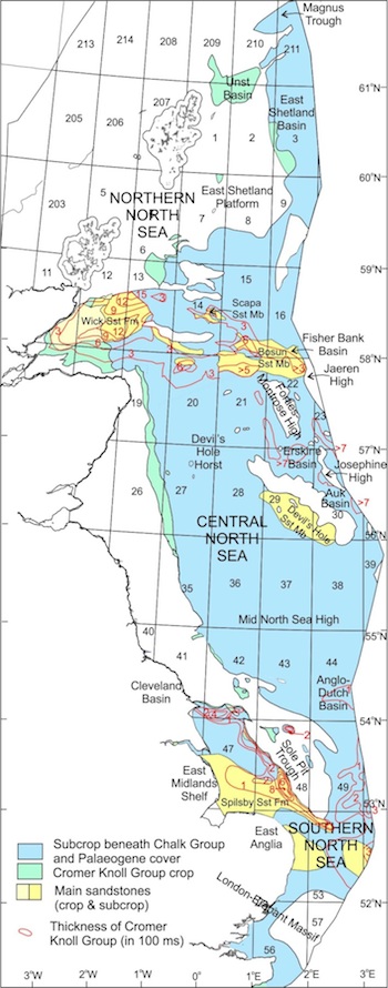
Distribution and thickness of the Cromer Knoll Group and main component sandstones (derived from Cameron et al., 1992, fig. 79; Gatliff et al., fig. 39; Andrews et al., 1990, fig. 34; Johnson et al., 1993, fig.47). |
Several formations are recognized within the group in the North Sea. In ascending order the Cromer Knoll Group includes the Valhall, Carrack and Rødby formations extending across the Northern, Central and Southern North Sea. More arenaceous units include the Spilsby Sandstone Formation of the Southern North Sea, Britannia Sandstone Formation of the Central North Sea and Wick Sandstone Formation of the Moray Firth.