|
|
|
|
|
from: Dallmann. W.K. (ed.). Svalbard lithostratigraphic lexicon
[ Selvågen Formation | Sesshøgda Formation | Reinhardpynten Formation | Krokodillen Formation ]
[ Marchaislaguna Formation | Aberdeenflya Formation ] BUCHANANISEN GROUP (T-24) 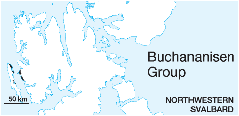
STATUS OF UNIT: Formal FIRST USE OF NAME: Here CURRENT DEFINITION: Harland 1969 SYNONYM(S) AND REFERENCE(S): "Forlandsundet Group": Harland 1969. The name is changed to Buchananisen Group to avoid confusion with the Forlandsundet Graben. The graben is a younger and narrower structure than the original sedimentary basin where the group was deposited. ORIGIN OF NAME: Buchananisen: A glacier on Prins Karls Forland TYPE AREA: Central eastern coast of Prins Karls Forland STRUCTURAL SETTING: Preserved in the post-depositionally formed Forlandsundet Graben DEPOSITIONAL AGE: ?Late Paleocene - Eocene - ?Early Oligocene. The age of the Buchananisen Group is poorly defined. Reliable fossil age determinations have only been reported from the Sarstangen conglomerate, which is not stratigraphically correlated with the other formations with certainty. The age is mainly interpreted from the general tectonic development of the Cenozoic basins of Svalbard (Livšic 1967, 1973, 1974; Steel & Worsley 1984; Steel et al. 1985; Gabrielsen et al. 1992). OVERLYING UNIT(S): None UNDERLYING UNIT(S): Pre-Old Red SUPERIOR UNIT: None OTHER USE OF NAME: None THICKNESS: >4000 m ? MAIN LITHOLOGIES: Sandstone, conglomerate, shale DESCRIPTION: The Buchananisen Group is a clastic sedimentary succession consisting of conglomerates, sandstones, siltstones and shales occurring within the Forlandsundet Graben, on both sides of Forlandsundet. For descriptions see individual formations (Selvågen, Sesshøgda, Reinhardpynten, Krokodillen, Marchaislaguna, Aberdeenflya formations and Balanuspynten conglomerates). The individual formations are local and in parts laterally interfingering (Livšic 1967, 1973, 1974; Rye Larsen 1982, unpubl.). The Forlandsundet Graben (Harland 1969) is a younger (and probably partly coeval) Cenozoic structure containing preserved deposits of an originally larger sedimentary basin (Gabrielsen 1992; Kleinspehn & Teyssier 1992). SELVÅGEN FORMATION (T-25) 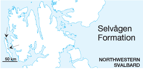
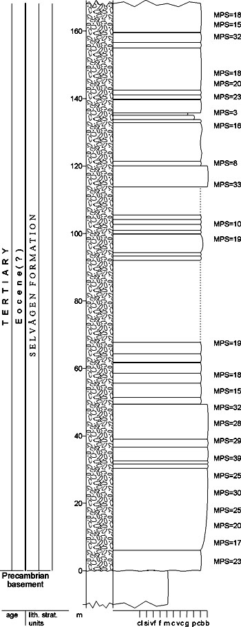
DISTRIBUTION shown in fig. 4-06 STATUS OF UNIT: Formal FIRST USE OF NAME: Atkinson 1962 CURRENT DEFINITION: Livšic 1967 SYNONYM(S) AND REFERENCE(S): "Selvågen conglomerate": Atkinson 1962 ORIGIN OF NAME: Selvågen (transl.: "The Seal Bay"): A bay on the eastern coast of Prins Karls Forland TYPE SECTION (fig. 4-40): Stratotype: Selvågen N, Thomsonfjella h. 431 m, Prins Karls Forland DEPOSITIONAL AGE: Late Paleocene - Eocene (?) DATING METHOD: Indirect, stratigraphic relationship REFERENCE(S) FOR AGE: See Buchananisen Group OVERLYING UNIT(S): Sesshøgda, Krokodillen and Aberdeenflya formations UNDERLYING UNIT(S): Pre-Old Red SUPERIOR UNIT: Buchananisen Group OTHER USE OF NAME: None THICKNESS: 40-170 m, 170 m in the stratotype (top not exposed) MAIN LITHOLOGIES: Conglomerate LOWER BOUNDARY DEFINITION: The base is defined by conglomerates on the angular unconformity above folded metamorphic basement. DESCRIPTION: The Selvågen Formation has been defined around the type area of Sesshøgda, Geddesfjellet and Krokodillen. Similar, lithostratigraphically correlatable, immature conglomerates are, however, preserved also to the north along the western Forlandsundet Graben margin on Buchananryggen and Aberdeenflya. The Selvågen Formation consists of polymict, pebbly to boulder-size greenish-grey to yellow and red conglomerates, often transitional to breccias, especially close to the western boundary faults of the Forlandsundet Graben. Rare intercalations of thin sandstones and siltstones occur. The thickness of the formation varies between 170 m and 40 m, thinning from west to east. The Selvågen Formation rests with an angular unconformity on Pre-Old Red metasediments and grades upwards into conglomeratic sandstones of the Sesshøgda Formation in the Selvågen - Krokodillen area. The Selvågen Formation represents mainly alluvial fanglomerate and talus deposits, deposited close to a tectonically active basin margin. Back to top SESSHØGDA FORMATION (T-26) 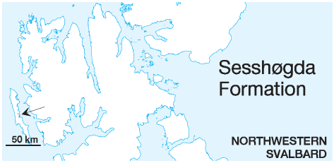
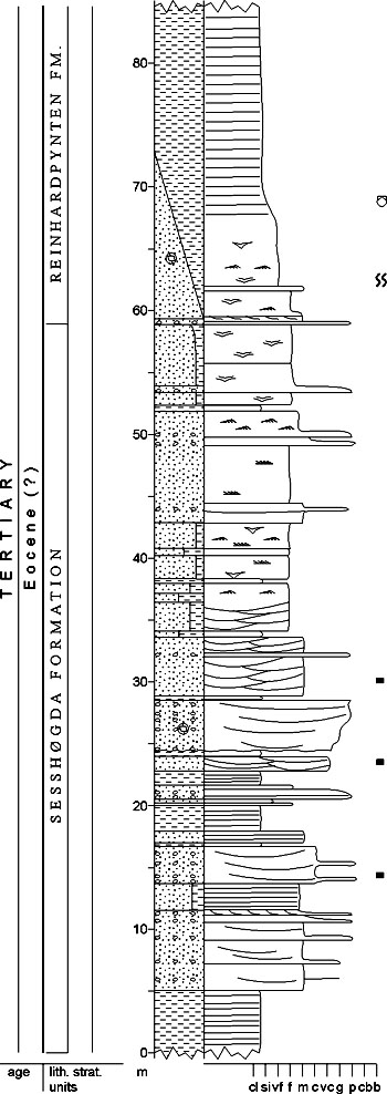
DISTRIBUTION shown in fig. 4-06 STATUS OF UNIT: Formal FIRST USE OF NAME: Livšic 1967 CURRENT DEFINITION: Livšic 1967 SYNONYM(S) AND REFERENCE(S): None. Part of the former "McVitie Formation" (Atkinson 1962) or "McVitiepynten Formation" (Birkenmajer 1972b). ORIGIN OF NAME: Sesshøgda (transl.: "The Seat Hill"): A mountain on central eastern Prins Karls Forland TYPE SECTION (fig. 4-41): Stratotype: Selvågen N, Prins Karls Forland DEPOSITIONAL AGE: Eocene (?) DATING METHOD: Indirect, stratigraphic relationship REFERENCE(S) FOR AGE: See Buchananisen Group OVERLYING UNIT(S): Reinhardpynten Formation UNDERLYING UNIT(S): Selvågen Formation SUPERIOR UNIT: Buchananisen Group OTHER USE OF NAME: None THICKNESS: 59 (stratotype) - 120 m MAIN LITHOLOGIES: Sandstone, siltstone, shale, conglomerate LOWER BOUNDARY DEFINITION: This boundary between conglomerates of the underlying Selvågen Formation and finer-grained clastics of the Sesshøgda Formation is relatively sharp in the type section. The boundary is defined, where sandstones, siltstones and shales start to dominate over conglomerates. DESCRIPTION: The Sesshøgda Formation comprises a largescale fining-upward succession. It consists of light grey, medium- to coarse-grained, conglomeratic, stratified sandstones alternating with siltstones and claystones in the lower part, grading upwards into fine-grained, more homogenous sandstones in the upper part. The sandstones in the lower part show mostly fining-upwards motifs and contain siderite concretions, whereas in the upper part they tend to be coarsening upward and contain pyrite concretions. The formation contains abundant plant remains. The Sesshøgda Formation has an apparently transitional boundary to the underlying conglomerates of the Selvågen Formation. The upper boundary is also gradational and is defined at the uppermost conglomerate bed under the more homogeneous siltstones of the Reinhardpynten Formation. The Sesshøgda Formation represents a large-scale transgressive succession, passing from alluvial and fan-delta plain facies in the lower part to fan-delta front and nearshore marine facies in the upper part. Back to top REINHARDPYNTEN FORMATION (T-27) 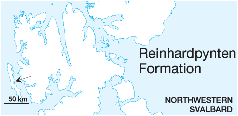
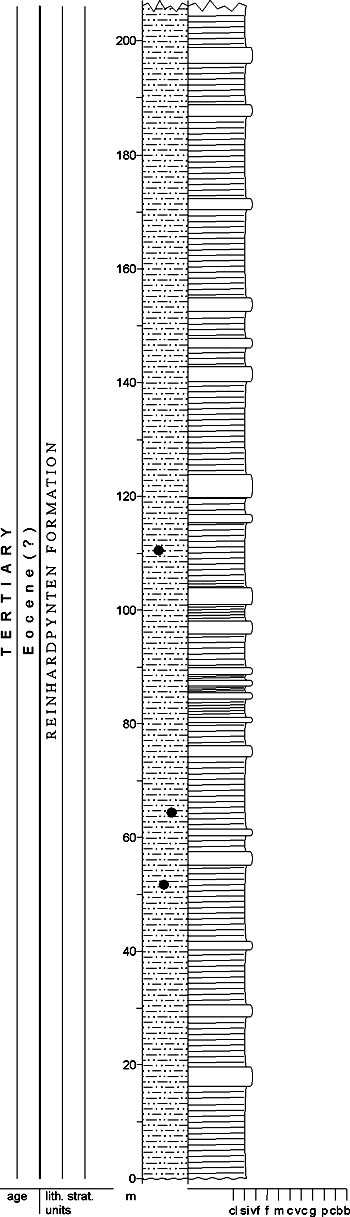
DISTRIBUTION shown in fig. 4-06 STATUS OF UNIT: Formal FIRST USE OF NAME: Livšic 1967 CURRENT DEFINITION: Livšic 1967 SYNONYM(S) AND REFERENCE(S): None. Part of the former "McVitie Formation" (Atkinson 1962) or "McVitiepynten Formation" (Birkenmajer 1972b). ORIGIN OF NAME: Reinhardpynten: A cape on central eastern Prins Karls Forland TYPE SECTION (fig. 4-42): Stratotype: Reinhardpynten, Prins Karls Forland DEPOSITIONAL AGE: Eocene (?) DATING METHOD: Indirect, stratigraphic relationship REFERENCE(S) FOR AGE: See Buchananisen Group OVERLYING UNIT(S): Krokodillen Formation UNDERLYING UNIT(S): Sesshøgda Formation SUPERIOR UNIT: Buchananisen Group OTHER USE OF NAME: None THICKNESS: >210 m in the stratotype MAIN LITHOLOGIES: Siltstone, shale, fine-grained sandstone LOWER BOUNDARY DEFINITION: The lower boundary is defined at the first appearance of homogeneous siltstones above the uppermost conglomerate bed of the Sesshøgda Formation. The basal 10 m of the Reinhardpynten Formation in the type section form a distinct fining-upward succession. DESCRIPTION: The Reinhardpynten Formation consists of dark grey, very fine sandstones and siltstones with pyrite and siderite concretions in the lower part, fining upwards into dark silty claystones with abundant carbonate concretions and floating quartzite pebbles. Some quartzitic sandstones with rare conglomerate bands occur at the top of the formation on northern Sessflya. The boundary to the overlying Krokodillen Formation is not exposed. The Reinhardpynten Formation contains a scattered marine bivalve fauna. The Reinhardpynten Formation has an overall transgressive character, passing upwards from nearshore to mostly distal marine facies. However, the uppermost sandstones probably represent nearshore, marine fan-delta deposits similar to the underlying Sesshøgda Formation. If these sandstones prove to have a significant thickness and can be mapped laterally, they should be considered for member status. However, the area is structurally complex and more work is needed in order to resolve the stratigraphy in more detail. Back to top KROKODILLEN FORMATION (T-28) 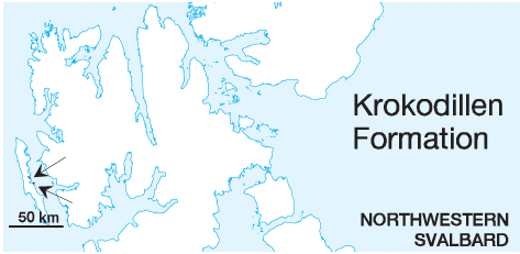
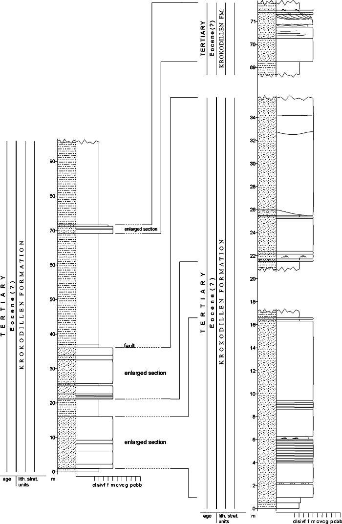
DISTRIBUTION shown in fig. 4-06 STATUS OF UNIT: Formal FIRST USE OF NAME: Livšic 1967 CURRENT DEFINITION: Livšic 1967 SYNONYM(S) AND REFERENCE(S): None. Part of the former "McVitie Formation" (Atkinson 1962) or "McVitiepynten Formation" (Birkenmajer 1972b). ORIGIN OF NAME: Krokodillen (transl.: "The Crocodile"): A mountain on central eastern Prins Karls Forland TYPE SECTION (fig. 4-43): Stratotype: Krokodillen N, Prins Karls Forland DEPOSITIONAL AGE: Eocene (?) DATING METHOD: Indirect, stratigraphic relationship REFERENCE(S) FOR AGE: See Buchananisen Group OVERLYING UNIT(S): Marchaislaguna Formation UNDERLYING UNIT(S): Selvågen and Reinhardpynten(?) formations SUPERIOR UNIT: Buchananisen Group OTHER USE OF NAME: None THICKNESS: 400 m (?), 110 m exposed in the stratotype MAIN LITHOLOGIES: Shale, sandstone LOWER BOUNDARY DEFINITION: The lower boundary is sharp and defined by shales overlying the conglomerates of the Selvågen Formation. Where the Reinhardpynten Formation occurs below the Krokodillen Formation, the boundary is not exposed well enough to give any precise definition. DESCRIPTION: The Krokodillen Formation consists of predominantly dark, silty claystones interbedded with 2-40 m thick light, fine-grained, almost quartzitic sandstones, sometimes coarsening upward. The type section at Krokodillen is highly faulted and the total thickness of the formation is estimated to 400 m. The Krokodillen Formation rests directly on the conglomerates of the Selvågen Formation at western Krokodillen. The boundary with the thick silty claystones and sandstones of the Reinhardpynten Formation to the south is not well exposed and therefore not well understood. It has been suggested, however, that the Krokodillen Formation conformably overlies the Reinhardpynten Formation. Upwards, the Krokodillen Formation is overlain, possibly erosively, by heterolithic sandstones and siltstones of the Marchaislaguna Formation. The Krokodillen Formation represents a mainly shallow marine facies. The massive, unstructured appearance of the sandstones and also the incipient cleavage in the claystones are attributed to deep burial with high heat and pressure alteration. Back to top MARCHAISLAGUNA FORMATION (T-29) 
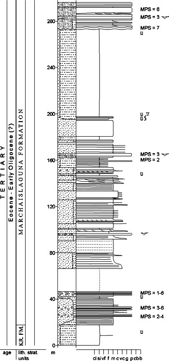
DISTRIBUTION shown in fig. 4-06 STATUS OF UNIT: Formal FIRST USE OF NAME: Livšic 1967 CURRENT DEFINITION: Livšic 1967 SYNONYM(S) AND REFERENCE(S): "Marchaise Formation": Livšic 1967. The place name segment is incomplete. Part of the former "McVitie Formation" (Atkinson 1962) or "McVitiepynten Formation" (Birkenmajer 1972b). ORIGIN OF NAME: Marchaislaguna: A small lagoon at the coast of central eastern Prins Karls Forland TYPE SECTION (fig. 4-44): Stratotype: Peter Winterbukta, Prins Karls Forland DEPOSITIONAL AGE: Eocene - Oligocene (?) DATING METHOD: Indirect, stratigraphic relationship REFERENCE(S) FOR AGE: See Buchananisen Group OVERLYING UNIT(S): None in outcrop UNDERLYING UNIT(S): Krokodillen Formation SUPERIOR UNIT: Buchananisen Group OTHER USE OF NAME: None THICKNESS: >600 m (?), 290 m exposed in the stratotype MAIN LITHOLOGIES: Sandstone, shale, conglomerate LOWER BOUNDARY DEFINITION: The boundary with the underlying Krokodillen Formation is defined at the onset of sandstones above the upper shales of the Krokodillen Formation. It is abrupt, possibly slightly erosive. DESCRIPTION: The Marchaislaguna Formation consists of alternating polymict, stratified, grey to yellowish, pebblesize conglomerates and medium-grained sandstones, interbedded with dark grey, sandy siltstones and claystones. Vertical tubular and U-shaped burrows, e.g. Skolithos, Arenicolites and Diplocraterion are common. The formation is dominated by sandstones and conglomerates in the lower and uppermost parts, whereas thicker units of sandy siltstones and claystones are common in middle and upper parts. The Marchaislaguna Formation is upwards truncated by the Recent erosion surface. The Marchaislaguna Formation represents a mainly shallow marine and fan-delta front facies. The large-scale variations between sandstone and conglomerate units as well as sandy siltstone and claystone units could possibly justify a further subdivision of the formation into members. Back to top ABERDEENFLYA FORMATION (T-30) 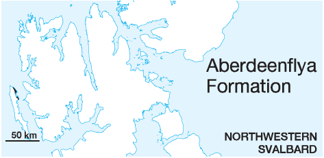
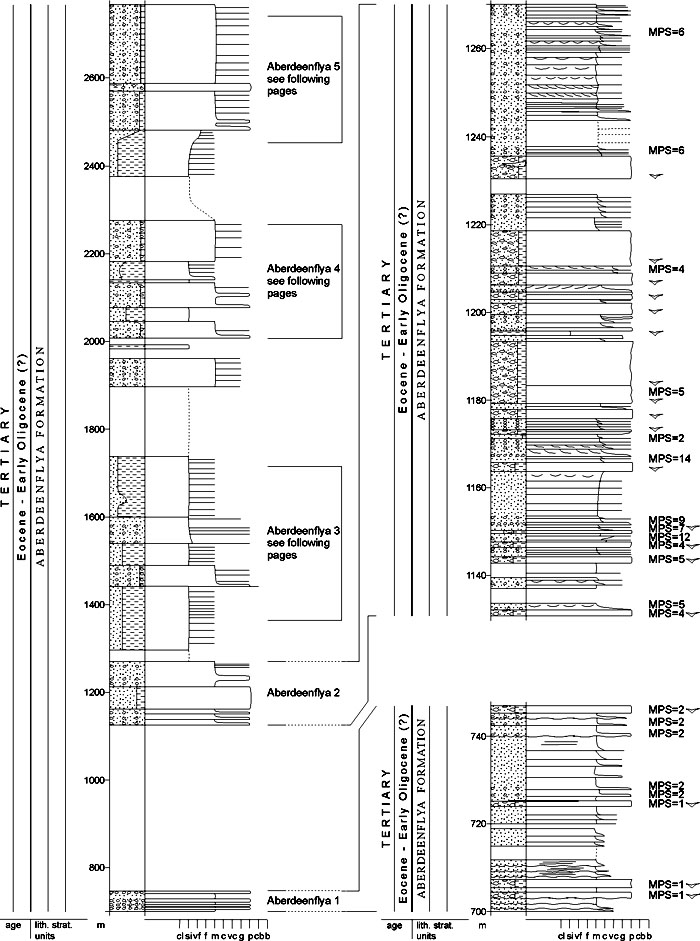
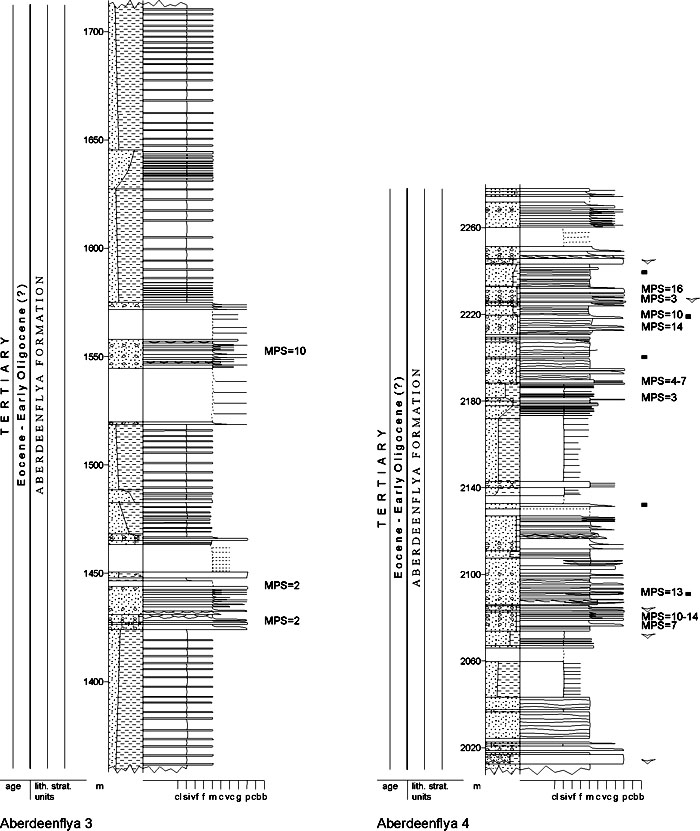
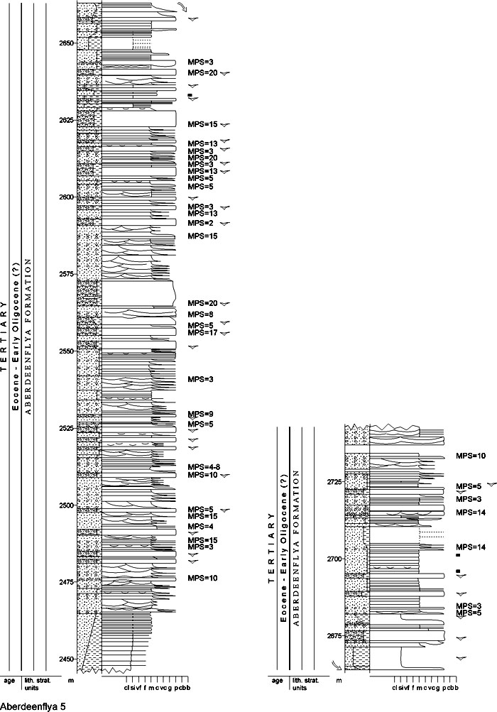
DISTRIBUTION shown in fig. 4-06 STATUS OF UNIT: Formal FIRST USE OF NAME: Here, following Rye Larsen 1982 (unpubl.) CURRENT DEFINITION: Here, following Rye Larsen 1982 (unpubl.) SYNONYM(S) AND REFERENCE(S): None ORIGIN OF NAME: Aberdeenflya: A coastal plain on northeastern Prins Karls Forland TYPE SECTION (figs. 4-45a, 4-45b, 4-45c): Stratotype: Aberdeenflya coast, Prins Karls Forland DEPOSITIONAL AGE: Eocene - Oligocene (?) DATING METHOD: Indirect, stratigraphic relationship REFERENCE(S) FOR AGE: See Buchananisen Group OVERLYING UNIT(S): None UNDERLYING UNIT(S): Selvågen Formation SUPERIOR UNIT: Buchananisen Group OTHER USE OF NAME: None THICKNESS: >2800 m (?) MAIN LITHOLOGIES: Conglomerate, sandstone, shale LOWER BOUNDARY DEFINITION: The lower boundary is poorly exposed, but lithologies of the Aberdeenflya Formation are underlain by immature conglomerates probably belonging to the Selvågen Formation, along the western boundary fault of the Forlandsundet Graben. The relationship with the probably older Marchaislaguna Formation is not known. DESCRIPTION: The Aberdeenflya Formation consists of alternating polymict, stratified, grey to yellowish, pebble-size conglomerates and fine- to medium-grained sandstones, interbedded with dark grey, sandy siltstones and claystones. Horizontal burrows are common. There is an overall coarsening-upward trend within the Aberdeenflya section, with thicker sandstone and conglomerate units and thinner sandy siltstone and claystone units upward. The formation is truncated by Recent erosion. The Aberdeenflya Formation represents mainly submarine fan and basin-floor facies. The large-scale variations between sandstone/conglomerate units and sandy siltstone/claystone units could argue for a further subdivision of the formation into members. The Aberdeenflya Formation is distinguished from the Marchaislaguna Formation as a separate unit because of uncertain stratigraphic relations across unexposed areas and because of slightly different lithological characteristics. Balanuspynten conglomerates (T-31) STATUS OF UNIT: Informal FIRST USE OF NAME: Here CURRENT DEFINITION: Here, following Atkinson 1963 SYNONYM(S) AND REFERENCE(S): "Sars Formation": Atkinson 1963. The place name segment is incomplete, referring either to Sarsøyra, Sarstangen or Sarsbukta. All these names are used for other stratigraphic units, the two latter for the two subunits of this one. ORIGIN OF NAME: Balanuspynten: A point on the eastern coast of Forlandsundet TYPE SECTION (figs. 4-46, 4-47): See Sarsbukta and Sarstangen conglomerates DEPOSITIONAL AGE: Eocene - Oligocene (?) DATING METHOD: Indirect, stratigraphic relationship REFERENCE(S) FOR AGE: See Buchananisen Group; Sarsbukta and Sarstangen conglomerates OVERLYING UNIT(S): None UNDERLYING UNIT(S): Pre-Old Red SUPERIOR UNIT: Buchananisen Group OTHER USE OF NAME: None THICKNESS: >1600 m (?) MAIN LITHOLOGIES: Conglomerate LOWER BOUNDARY DEFINITION: The base is not exposed, but the unit's conglomerates must rest unconformably on folded metamorphic basement. DESCRIPTION: The name Balanuspynten conglomerates is assigned to Cenozoic conglomerates and intercalated sandstones and shales which occur on the eastern shore of Forlandsundet. The Balanuspynten conglomerates represent the only outcrop of Cenozoic strata on the eastern side of Forlandsundet. No continuous stratigraphic section is exposed, and relations between the two subunits (Sarsbukta and Sarstangen conglomerates are not known). The correlation with strata on the western side of Forlandsundet is not known. Documentation of the unit is poor. Back to top Sarsbukta conglomerate (T-32) 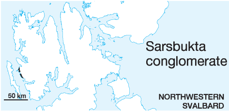
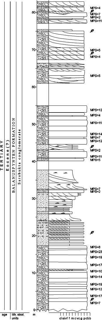
DISTRIBUTION shown in fig. 4-06 STATUS OF UNIT: Informal FIRST USE OF NAME: Here, following Rye Larsen 1982 (unpubl.) CURRENT DEFINITION: Here, following Rye Larsen 1982 (unpubl.) SYNONYM(S) AND REFERENCE(S): None ORIGIN OF NAME: Sarsbukta: A bay on the eastern coast of Forlandsundet TYPE SECTION (fig. 4-46): Unit stratotype: Sarsøyra DEPOSITIONAL AGE: Eocene DATING METHOD: Indirect, stratigraphic relationship REFERENCE(S) FOR AGE: See Buchananisen Group OVERLYING UNIT(S): Sarstangen conglomerate UNDERLYING UNIT(S): Pre-Old Red SUPERIOR UNIT: Buchananisen Group, (Balanuspynten conglomerates) OTHER USE OF NAME: None THICKNESS: ca. 600 m (?) MAIN LITHOLOGIES: Conglomerate LOWER BOUNDARY DEFINITION: See Balanuspynten conglomerates DESCRIPTION: The Sarsbukta conglomerate consists of polymict, pebbly to boulder size, grey to yellow-red, partly stratified conglomerates, with interbeds of medium- to coarse-grained sandstones and rare thin siltstones. The Sarsbukta member occurs from Sarsbukta southwards on Kaffiøyra, and a minimum total thickness of 600 m can be estimated. The Sarsbukta conglomerate contains scattered plant debris. The conglomerate has a faulted contact with the Pre-Old Red to the east. The lower boundary is not exposed. The boundary with the Sarstangen conglomerate is not clear, but the latter is likely to unconformably overlie the Sarsbukta conglomerate. Back to top Sarstangen conglomerate (T-33) 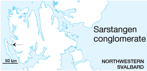
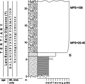
DISTRIBUTION shown in fig. 4-06 STATUS OF UNIT: Informal FIRST USE OF NAME: Here, following Rye Larsen 1982 (unpubl.) CURRENT DEFINITION: Here, following Rye Larsen 1982 (unpubl.) SYNONYM(S) AND REFERENCE(S): None ORIGIN OF NAME: Sarstangen: A cape on the eastern coast of Forlandsundet TYPE SECTION (fig. 4-47): Stratotype: Sarsbukta. The borehole at Sarstangen is probably more suitable, but the log data have not been released by the owners (Norsk Polar Navigasjon 1974). DEPOSITIONAL AGE: Latest Eocene - (?Early) Oligocene DATING METHOD: Foraminifera, dinoflagellates, palynology REFERENCE(S) FOR AGE: Manum 1960, 1962; Feyling-Hanssen & Ulleberg 1984; Manum & Throndsen 1986; Livšic 1992; unpubl. data, Norsk Hydro 1996 OVERLYING UNIT(S): None UNDERLYING UNIT(S): Pre-Old Red, Sarsbukta conglomerate (?) SUPERIOR UNIT: Buchananisen Group, (Balanuspynten conglomerates) OTHER USE OF NAME: None THICKNESS: >1050 m (?) MAIN LITHOLOGIES: Conglomerate LOWER BOUNDARY DEFINITION: The lower boundary is defined by conglomerates resting on an angular unconformity above folded metamorphic basement (borehole data). The boundary with the Sarsbukta conglomerates to the east is presently unclear, but another, low-angle unconformity is suggested (K. Kleinspehn, written comm. 1997). DESCRIPTION: The Sarstangen member consists of interbedded, commonly stratified conglomerates, fine- to coarsegrained sandstones or conglomerates and siltstones. The formation is present along the coast from Sarsøyra to Kaffiøyra, but the exact thickness is not known. The borehole at Sarstangen (Norsk Polar Navigasjon 1974) shows 1050 m of probable Sarstangen conglomerate strata unconformably overlying folded and metamorphic basement. The unit contains abundant plant remains. The Sarstangen member represents mixed alluvial fan toe and alluvial plain facies. The main difference from the Sarsbukta member is the presence of alluvial plain sandstones and siltstones, as well as a distinctly less consolidated texture and lack of deformation. Back to top |