 |
|
|
|
(Original definition in NPD Bulletin no. 5)
updated to follow: Stratigraphic Guide to the Cromer Knoll, Shetland and Chalk Groups of the North Sea and Norwegian Sea. Felix M. Gradstein & Colin C. Waters (editors), Mike Charnock, Dirk Munsterman, Michelle Hollerbach, Harald Brunstad, Øyvind Hammer & Luis Vergara (contributors). Newsletter on Stratigraphy, vol 49/1 pp71-280, 2016
The original definition of the Cromer Knoll Group is in Isaksen and Tonstad (1989). In the Norwegian Sea the group originally included the Lyr, Lange and Lysing Formations, and extended across the Lower/Upper Cretaceous boundary. Thus, it was of greater stratigraphic extent than the Cromer Knoll Group in the North Sea, where it essentially is a Lower Cretaceous argillaceous unit. We have redefined the stratigraphic extent of the Group such that the Norwegian and North Sea definitions agree more closely.
The type area for the Cromer Knoll Group is in the southern North Sea. Rhys (1974) used UK well 48/22-2 to illustrate a typical section of the group, and Deegan & Scull (1977) used UK wells 29/25-1, 22/1-2A and 3/29-1, and Norwegian well 2/11-1.
The emphasis in this paper is on the Norwegian sector, and for this purpose wells 6506/12-1 and 12-4 are used to illustrate local developments of the group. Other wells useful to study the Group are 2/6-2, 2/7-15, 2/11-1, 7/3-1, 17/11-2, 34/10-18, 35/3-4, 35/3-5, 31/6-3, 24/12-2 and 17/4-1; the Danish well DK1-1 has also been used.
The thickness of the group varies considerably. In the Viking Graben, the Asta Graben and locally in the Central Trough the thickness is often more than 600 m, gradually thinning towards the basin margins. The group is 667 m thick in Norwegian well 2/11-1 and 643 m thick in Norwegian well 17/11-1. Seismic data indicate that the group is thickest in the Sogn Graben, where it probably reaches up to 1400 m in thickness.
Figure 1 shows depth to the base of the Cromer Knoll Group (revised definition) in the Norwegian Sea based on released well data. The wells displayed are those that penetrated the base of the group.
Figure 2 shows depth to the top of the Cromer Knoll Group (revised definition) in the Norwegian Sea based on released well data. This follows the revised definition that corresponds to the top Lower Cretaceous, and coincides with the level applied in the North Sea. The wells displayed are those that penetrated the group.
The thickness of the group varies considerably since the sediments were deposited in response to an active Late Jurassic tectonic phase. In the Viking Graben, the Asta Graben and locally in the Central Trough the thickness is often more than 600 m, gradually thinning towards the basin margins. The group is 667 m thick in Norwegian well 2/11-1 and 643 m thick in Norwegian well 17/11-1. Seismic data indicate that the group is thickest in the Sogn Graben, where it probably reaches up to 1400 m.

Fig 1: Depth to the base of the Cromer Knoll Group (revised definition) in the Norwegian Sea based on released well data. The wells displayed are those that penetrated the base of the group. Click for PDF. |
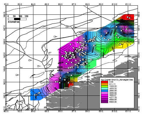 Fig 2: Depth to the top of the Cromer Knoll Group (revised definition) in the Norwegian Sea based on released well data. This follows the revised definition that corresponds to the top Early Cretaceous and coincides with the level applied in the North Sea. The wells displayed are those that penetrated the group. Click for PDF. |
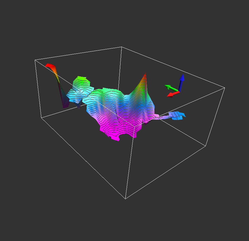 3D image of the depth to the base of the Cromer Knoll Group (revised definition) in the Norwegian Sea based on released well data. Note that the figure is viewed from a location in the SE (Møre Basin) looking towards the NW (Trøndelags Platform). The green arrow is the North pointer. The grid is based on the updated NorLex well data for this group and the revised NorLex definition of the Cromer Knoll Group. Click for large version. |
 3D image of the depth to the top of the Cromer Knoll Group (revised definition) in the Norwegian Sea based on released well data. |
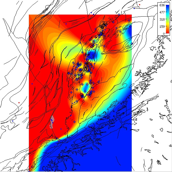
Regional isopach of the Cromer Knoll Group thickness in the Norwegian Sea based on released well data.
The group thicknesses follow the revised definition that corresponds to the top Early Cretaceous and coincides with the North
Sea level.
The isochore map is generated from Norlex data using thin plate splines (thickness constrained to original range).
Thicknesses in metres.
Circled well contain both horizons. The red wells have Norlex biostratigraphy. |
Logs of reference well 6506/12-1, former stratigraphic extent
Logs of reference well 6506/12-1, redefined extent
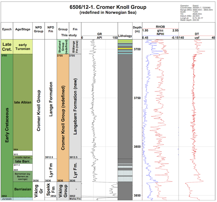
Reference well 6506/12-1 (click to enlarge)
Logs of reference well 6506/12-4, former stratigraphic extent
Logs of reference well 6506/12-4, redefined extent
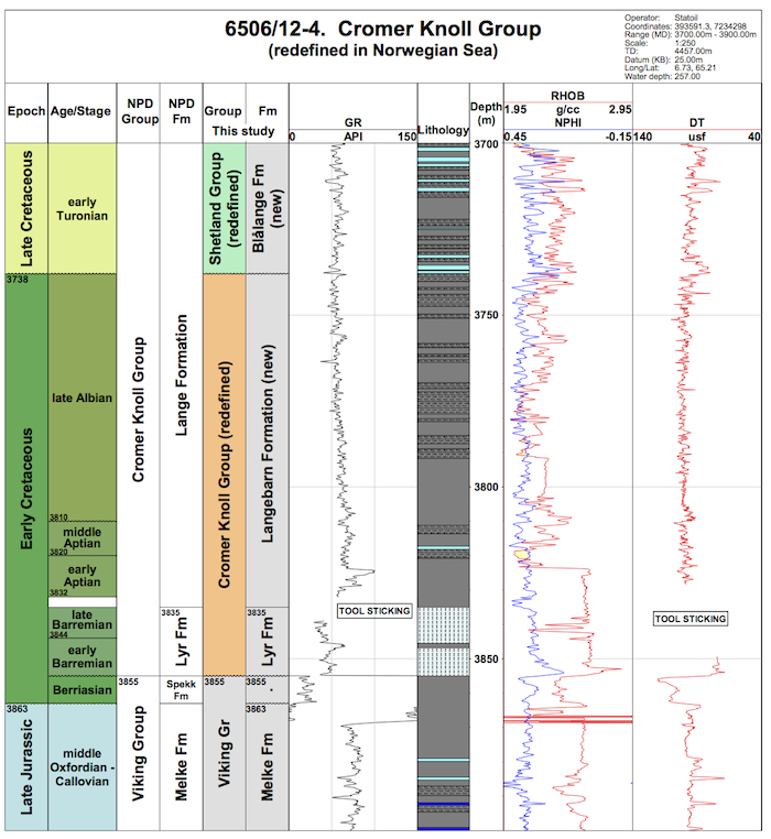
Reference well 6506/12-4 (click to enlarge)
The Cromer Knoll Group is partly equivalent to the Rijnland Group of the Dutch sector (NAM & RGD 1980, Crittenden 1982) and the Speeton Clay Formation together with the Red Chalk Formation of the UK sector (Rhys 1974).