 |
|
|
|
updated to follow: Stratigraphic Guide to the Cromer Knoll, Shetland and Chalk Groups of the North Sea and Norwegian Sea. Felix M. Gradstein & Colin C. Waters (editors), Mike Charnock, Dirk Munsterman, Michelle Hollerbach, Harald Brunstad, Øyvind Hammer & Luis Vergara (contributors). Newsletter on Stratigraphy, vol 49/1 pp71-280, 2016
Grindhval Member | Hvithval Member
The definition of the Springar Formation follows Dalland et al. (1988). The formation is generally a thick, widespread sequence of marine mudstones developed throughout the Norwegian Sea region.
Two new sandstone members are defined within this formation:
1. The Hvithval Member, an interval of sandstones locally found in the Vøring Basin, and assigned a Campanian-Maastrichtian age.
2. The Grindhval Member, a unit of sandstones present in the Ormen Lange Field in the Møre Basin, assigned a late Maastrichtian age.
Derivatio nominis:A Norwegian collective name for small whales (Dalland et al., 1988) or more accurately, a group of toothed, sea going dolphins (Delphinidae) of the genus Lagenorhynchus e.g. Kvitnos. It has not been possible to use names from springar-types to define the two members since the name Kvitnos is already occupied for a formation. The names of the two new members Hvithval and Grindhval are considered appropriate since these are also small to moderate sized toothed whale species.
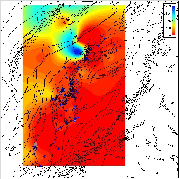
Regional isochore of the Springar Formation thickness in the Norwegian Sea based on released well data.
The isochore map is generated from Norlex data using thin plate splines (thickness constrained to original
range).
Thicknesses in metres.
Circled wells contain both top and base horizons.
The red wells have Norlex biostratigraphy. Click for large version.
|
The Springar Formation is widely distributed in the Norwegian Sea region. The thickness ranges from 9 m in e.g. well 6407/7-4, where it is truncated by subsequent Paleocene erosion, to the exceptionally thick 1753 m, e.g. in well 6607/12-1. In the latter well the base of the formation was not reached at the well TD. The anomalous thickness is attributed to the well being drilled in a mini-graben-like feature, close to a fault plane on the western margin of the Dønna Terrace.
With the exception of well 6607/12-1, the greatest thicknesses are typically in the Vøring Basin where the formation contains sandstones of the Hvithval Member. In this area the formation still reaches thicknesses over 1000 m, e.g. in well 6704/12-1. On the Halten and Dønna Terrace areas, the Springar Formation is typically between 100 m -200 m in thickness, diminishing to less than 100m in the southern part of the Halten Terrace e.g. in well 6306/6-1 and around the Nordland Ridge, where it is thin or locally absent, e.g. in well 6608/11-1.
Sandstones of the Hvithval Member are geographically restricted to the Vøring Basin, and those of the Grindhval Member are locally developed in the Møre Basin.
Reference well 6506/12-1: 31 slides (dc and 2 swc at 2337 m and 2415 m) from samples covering the interval 2280 m - 2440 m (Stratlab, RRI and OD preparations) available at the Norwegian Petroleum Directorate.
WGS84 coordinates: N 65°12'46.97, E 06°43'30.37
UTM coordinates: 7234298.1 N 393591.29 E
UTM zone: 32
Drilling operator name: Den norske stats oljeselskap a.s. (Statoil a.s.)
Completion date: 13.08.1985
Status: P & A
Interval of type section & thickness in type well:
2380 m - 2211 m, 169 m thickness.
Click for large version (PDF)
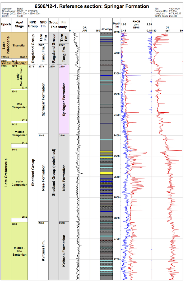
WGS84 coordinates: N 65°10'07.58, E 06°43'44.07
UTM coordinates: 7229359.52 N 393591.68 E
UTM zone: 32
Drilling operator name: Den norske stats oljeselskap a.s. (Statoil a.s.)
Completion date: 06.02.1985
Status: P & A
Interval of type section & thickness in reference well:
2446 m - 2279 m, 167 m thickness.
Click for large version (PDF)
The top of the Springar Formation coincides with the top of the Shetland Group, and with the Cretaceous/Paleogene boundary. The top normally coincides with stratigraphic break of varying extent, but Danian sediments are typically absent in wells in the Halten Terrace - Dønna Terrace areas. The boundary with the overlying Tang Formation is usually defined by a marked downward decrease in sonic velocity, and an increase in density values. This log feature reflects the unconformity. Limestones are generally more prominent in the Springar Formation than in the overlying Tang Formation; locally, a limestone stringer occurs at the top surface.
The lower boundary of the Springar Formation appears to be close to the top of the lower Campanian as defined by the dinoflagellate cyst event LAO Trithyrodinium suspectum. This is the key marker for the base of the Springar Formation. In stratigraphically complete sections, unaffected by erosion in response to the base Cenozoic/top Cretaceous unconformity, e.g. in Ormen Lange well 635/5-1, the upper boundary of the Springer Formation is of late Maastrichtian age and characterised by the last occurrence of planktonic foraminifera, notably LO Rosita contusa, LO Abathomphalus mayaronsis, LO Racemiguembelina fructicosa, LO Globigerinelloides asper, LO Heterohelix spp., and the dinocyst LO Palynodinium grallator.
In the area of the type and reference wells located on the western margin of the Trøndelags Platform, the top of the Springer Formation is truncated and of early Maastrichtian or intra-late Maastrichtian age, as defined by the LO Triblastula utinensis, LO Odontochitina operculata and/or Hystrichodinium pulchrum. The stratigraphic break with the overlying onlapping sediments of the Middle Paleocene Tang Formation is on the order of 10 m.y. in duration.The Springar Formation was generally deposited in a deep outer shelf to bathyal paleoenvironment, with somewhat restricted water circulation. There are indications of temporary periods of more open marine circulation in response to the episodic opening of the Cretaceous seaway between Norway and Greenland (Gradstein et al., 1999). Deep water, non-calcareous agglutinated foraminifera (DWAF) dominate the microfossil assemblage, with calcareous benthonic foraminifera, planktonic foraminifera and radiolarians present at certain levels.
Færseth, R. and Lien, T. 2002 Cretaceous evolution in the Norwegian Sea - a period characterized by tectonic quiescence. Marine and Petroleum Geology, 19, 1005 -1027.
Gradstein, F., Kaminski, M.A. and Agterberg, F.P. 1999. Biostratigraphy and paleoceanography of the Cretaceous seaway between Norway and Greenland. Earth-Science Reviews, 46, 27-98.
Swiecicki, T., Gibbs, P.B., Farrow, G.E. and Coward, M.P. 1998. A tectonostratigraphic framework for the Mid-Norway region. Marine and Petroleum Geology, 15, 245-276.
Vergara, L., Wreglesworth, I., Trayfoot, M., Richardsen, G. 2001. The distribution of
Cretaceous and Paleocene deep-water reservoirs in the Norwegian Sea basins. Petroleum
Geoscience, 7, 395-408.
| home | previous page |