 |
|
|
|
For earlier definition, see NPD Bulletin no. 5.
updated to follow: Stratigraphic Guide to the Cromer Knoll, Shetland and Chalk Groups of the North Sea and Norwegian Sea. Felix M. Gradstein & Colin C. Waters (editors), Mike Charnock, Dirk Munsterman, Michelle Hollerbach, Harald Brunstad, Øyvind Hammer & Luis Vergara (contributors). Newsletter on Stratigraphy, vol 49/1 pp71-280, 2016
After the Tor Field in Norwegian blocks 2/4 and 2/5 (Deegan & Scull, 1977, p.27). Tor was a son of Odin, and one of the principal Gods of Norse mythology.
Norwegian Sector: The Tor Formation is in general very clean with a low content of insolubles (<5%). The clean nature of the chalk is reflected in the light colour and the evidence of pressure solution in the form of dental stylolites. Dental stylolites are typical of clean chalk, while the pressure solution in the more dirty chalks appears as horsetails solution seams. The Tor Formation is composed of mixed pelagic and allochthonous chalks. There is a gradual upward increase in the amount of allochthonous material.
The distribution of sedimentary facies is driven by paleo-topography, so that what is seen today is the combined result of primary deposition and secondary processes in the form of reworking and diagenesis. Therefore, to understand the depositional facies, the location of the individual wells with respect to regional structural features (basinal axis, margins and inversion ridges) and more local halokinetic structures, is critical.
Norwegian Sector: Tor thicknesses in the study wells vary from 0 m in Baron-2 to 472 m in Well 1/3-8. The thickness variations in the study wells are however not representative of the North Sea Basin Chalk/ Tor Formation distribution as most wells are drilled on structural highs.
UK Sector: On intra-basinal and graben-marginal ridges the formation is generally less than 150 m thick. However, the formation is more than 250 m thick in depocentres within the Central Graben, locally reaching over 500 m (Johnson & Lott, 1993). In the Outer Moray Firth the formation is typically about 200 m thick, up to 500 m thick in the Wick Sub-basin (Andrews et al., 1990).
Norwegian Sector: Regional thickness maps based on seismic interpretation show a general thickening of the Upper Cretaceous package from southeast to northwest in the Central Graben system (Britze et al, 1995, Ziegler, 1990, Japsen, 1998). This general observation has an overprint of local east or west depocentres going from north to southeast along the Graben axis. This pattern is confirmed by the study wells also for the Tor Formation alone.
UK Sector: The Tor Formation is the most widespread of the Chalk Group formations, and occurs throughout the Central North Sea, including the Forties-Montrose High. It also extends into the South Viking Graben and onto the East Shetland Platform, where it rests on Jurassic and older rocks. It is absent from the graben margin of the Western Platform and parts of the Halibut Horst (Johnson & Lott, 1993).
WGS84 coordinates: Lat. 56º 51’ 21”N Long. 02º 51’ 05”E
UTM coordinates: 6301488.86 N 490936.87 E
UTM zone: 31
Drilling operator name: A/S Norske Shell
Completion date: 11.11.1968
Status: P & A
Interval of type section & thickness in type well: 3354-3827.5 m (11004-12558 ft) below KB.
(Deegan & Scull, 1977, p.27, fig.30; Tonstad & Isaksen, 1989). No cores.
16/17-6: 2964-3249 m (9724-10660 ft) |
Lat. 58º 25’ 55.6”N Lat. 57º 56’ 12.2”N Lat. 56º 50’ 37.0”N Lat. 56º 18’ 10.023”N |
Long. 01º 18’ 26.0”E Long. 01º 02’ 55.8”E Long. 01º 45’ 14.4”E Long. 01º 51’ 48.758”E |
The Mona-1 well is chosen as a one of two reference sections for the Tor Formation. The stratigraphic sequence in Mona-1 is relatively complete with individual zones being represented by a significant thickness. Except for the very top the Tor Formation is cored throughout this well. Discovery well for the Tor Field, well 2/5-1, is chosen as a second reference section for the Tor Formation. Only the upper half of the Tor Formation is cored but the 2/5-1 well has all Tor zones well developed.
Norwegian Sector: In general the Top Tor is of the same age over the study area. The duration of the Tor/Ekofisk hiatus mostly depends on how much is missing from the Ekofisk Formation. Locally, all of the Ekofisk Formation is missing in the crestal parts of the Hod and Valhall Fields. Here the Tor Formation, or reworked Tor Formation, is overlain by Paleocene shales (2/8-A-1). The GR generally shows an increase. The Top Tor pick is usually put at the start of the increase. In accordance with a shift to lower porosities in the bottom part of the Ekofisk Formation the velocity shows a clear increase at Top Tor. However, the uppermost part of the Tor Formation can be well cemented and as a result appear exactly like the Ekofisk Formation on density and velocity logs. In the absence of good biostratigraphic data the usual slight increase in GR should enable an accurate log pick, though. A relative decrease in resistivity across the Tor/Ekofisk boundary is seen. This picture is consistent even though the resistivity in the top part of the Tor Formation is affected by pore fluids (water, oil or gas).
UK Sector: The top of the formation is marked by a downward change from relatively argillaceous chalky limestones of the Ekofisk Formation to relatively clean limestones. Thin argillaceous units are present locally and, in the northern parts of the Central Graben, expansion of these argillaceous units leads to uncertainty as to the correct pick for the upper boundary (Johnson & Lott, 1993).
Norwegian Sector: In general the lower Tor boundary is difficult to pick on logs. A decrease in the GR level, small or large, is common, though quite often no change of the GR level is observed. In the stratigraphically more complete wells there seems to be a regional element to the log characteristics. In the northern basin wells the sonic log shows an increase in velocity upon entering the Tor Formation from the Magne Formation below. This is associated with either no change or a slight increase in the density reading, i.e. lower porosity. From the Lindesnes Ridge and southeastwards the sonic log shows a decrease in velocity crossing from Magne to Tor Formation. This is associated with either no change or a slight decrease in the density reading, i.e higher porosity. Where nannozones UC16-18 are thin or missing a change to lower porosity associated with an increase in velocity is observed at the boundary. These are observations of a general nature and exceptions can be found. The resistivity logs to some degree mirror the sonic and density logs in water bearing chalk. Where the velocity and density go up an increased resistivity is often seen, reflecting a more dense rock, and vice versa. Exceptions are wells where the bottom part of the Tor Formation is porous and oil-bearing. Here a decrease in velocity and density is accompanied by an increase in resistivity. The lower boundary either coincides with the boundary between biozones UC16 and 18 (UC17 is only scarcely present) or is placed midway in UC16.
UK Sector: The base of the Tor Formation is normally marked by a relatively abrupt downward change from the hard chalky limestones to the interbedded argillaceous chalky limestones, which are commonly stained pink or red top of the Mackerel Formation (Johnson & Lott, 1993). Over intrabasinal and graben-margin ridges, the Tor Formation overlies Lower Cretaceous and older sediments (e.g. 29/23-1)
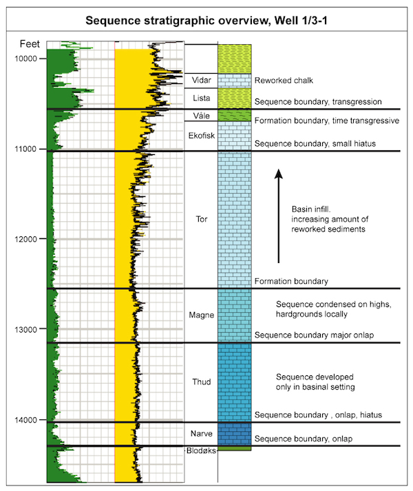
Norwegian Sector: The Tor Formation seismic package is characterised by well-defined continous reflectors in the upper half, while the lower half most often show less distinct reflectors. This difference is most pronounced in the northern part of the study area, where the formation is also the thickest. It is probable, that the lower half is simply better developed to the north and that these deeper layers have a very thin development southeastwards in the basin resulting in more pronounced reflectors. Neither the Base nor the Top Tor boundary are seismically distinct reflectors and would be difficult to pick without well-tie. Onto the Lindesnes Ridge a major part of the Tor package disappears. The 2/7 and 2/8 wells show that the missing part is from top down.
UK Sector: The top of the formation is marked by a downward decrease in gamma-ray values and forms a strong, regionally developed seismic reflector (Andrews et al., 1990). The formation is characterized by an almost featureless log response and high, uniform velocity values (Deegan & Scull, 1977). Beds of relatively porous, slumped and chaotically bedded chalky limestone are marked by low velocity peaks and distinctive porosity and dipmeter log responses (Johnson & Lott, 1993). On wireline logs, the lower boundary of the formation corresponds to a downward increase in gamma-ray values and decrease in velocity.
Norwegian Sector: The age of the Tor Formation has in this study been decided to encompass all of the Maastrichtian, i.e. nannofossil zones UC17 through 20 and foram zones FCS22 through FCS23. The base of the Formation is in the middle of zone UC16 near 74 Ma.
At the detailed level the top of zone UC16, which is of late Campanian age, cannot in all wells be brought to coincide with well-defined log breaks. This is a problem that remains even after careful integration of all data. UC17 and 18 are early Maastrichtian. UC19 and 20 are late Maastrichtian and encompasses the upper part of nannoplankton Zone UC16 through to Zone UC20 and the two foraminiferid Zones FCS22 and FCS23, both of which have been further divided into subzones. There is considerable biostratigraphic evidence for intra-formational reworking within the Tor Formation throughout the study region. Several wells contain sections where late Campanian and early Maastrichtian Tor sediments have been re-deposited during late Maastrichtian. There is also evidence of reworking within late Maastrichtian. Despite the frequent presence of stacked allochthonous chalk units within the Tor Formation, the ages of individual units can be ascertained on the basis of the characteristic nannofloral and microfaunal associations. Many of the well sections examined include very thin and condensed late Campanian to early Maastrichtian intervals, suggesting active structural growth during this period. The maximum phase of allochthonous chalk deposition is during the late Maastrichtian resulting in considerable variation in formation thickness across the region.
UK Sector: The top of the Tor Formation is marked by the Pseudotextularia elegans foraminiferal biomarker and the Nephrolithus frequens calcareous nannofossil biomarker (Johnson & Lott, 1993). The FDO (First Downhole Occurrence) of Reussella szajnochae is present in the middle part of the formation, but is rare. The Gavelinella spp. / Bolivinoides miliaris biomarker occurs in the lower part of the formation. The Reinhardtites levis nannofossil biomarker is an important marker for the early/late Maastrichtian boundary, at about the same level as the FDO for R. szajnochae. The Gatnerago obliquum, Tranolithus orionatus and Broinsonia parca biomarkers also occur within the formation. The presence of the Reinhardtites anthophorus biomarker in some wells suggests the base of the formation locally extends into the latest Campanian (Johnson & Lott, 1993).
The Palynodinium grallator and Odontochitina operculata dinoflagellate cysts biomarkers are present in the formation, the former dominating in the uppermost part (Costa & Davey, 1992). The age of the Tor Formation has in this study been decided to encompass all of the Maastrichtian, i.e. nannofossil zones UC17 through 20 and foram zones FCS22 through FCS23. The base of the Formation is in the middle of zone UC16 near 74 Ma.
Early Maastrichtian, locally latest Campanian, to latest Maastrichtian.
The chalky limestones occur as two facies:
1) pelagic chalky, coccolith-rich limestones with varying proportions of detrital clay (Johnson & Lott, 1993), with phases of more open marine circulation indicated by a higher proportion of planktonic foraminifera in the latest Maastrichtian (King et al., 1989); and
2) an allochthonous facies formed of sediments originating from the redeposition of slumped sediments derived from the flanks of the graben (Johnson & Lott, 1993).
No formal subdivisions are recognized in UK or Norwegian waters. On the basis of lithological and porosity characteristics, Hatton (1986) informally subdivided the Tor Formation in the Central North Sea and recognized sixteen single, or multiple, high-porosity allochthonous chalk units.
| home | previous page |