 |
|
|
|
|
from: Dallmann. W.K. (ed.). Svalbard lithostratigraphic lexicon
[ Campbellryggen Subgroup | Hultberget Formation | Ebbadalen Formation | Minkinfjellet Formation ]
[ Charlesbreen Subgroup | Brøggertinden Formation | Scheteligfjellet Formation | Petrellskaret Formation | Tårnkanten Formation ] [ Treskelen Subgroup | Hyrnefjellet Formation | Treskelodden Formation | Dickson Land Subgroup | Wordiekammen Formation ] [ Gipshuken Formation | Malte Brunfjellet Formation | Hårbardbreen Formation | Landnørdingsvika Formation ] [ Kapp Kåre Formation | Kapp Hanna Formation | Kapp Dunér Formation ] GIPSDALEN GROUP (CP-23) 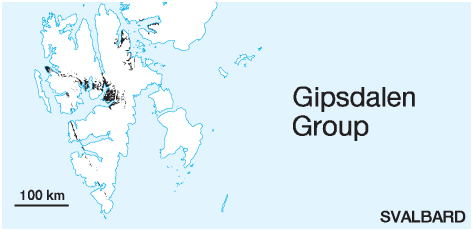 STATUS OF UNIT: Formal
FIRST USE OF NAME: Cutbill & Challinor 1965 CURRENT DEFINITION: Cutbill & Challinor 1965 SYNONYM(S) AND REFERENCE(S): None ORIGIN OF NAME: Gipsdalen (transl. "Gypsum Valley": A broad glacier valley in Bünsow Land, central Spitsbergen TYPE AREA: Gipsdalen and adjacent mountains in Bünsow Land, central Spitsbergen STRUCTURAL SETTING: Late Palaeozoic platform of Svalbard and the Barents Sea Shelf 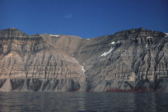
Fig. 2-34: The Carboniferous succession north of Anservika (Billefjorden), showing redbeds of the Hultberget Formation (hypostratotype) in a fault slice at sea level, and the Wordiekammen (yellowishgrey carbonate rocks), Gipshuken (white gypsum and grey dolomite rocks) and Kapp Starostin formations (upper yellowish and grey spiculitic rocks and limestones). The Cowantoppen Fault (a strand of the Billefjorden Fault Zone) cuts the right part of the photo subparallel to the slope. Photo: H.B. Keilen DEPOSITIONAL AGE: Serpukhovian - Artinskian OVERLYING UNIT(S): Tempelfjorden Group; locally on Sørkapp-Hornsund High: Sassendalen Group UNDERLYING UNIT(S): Billefjorden Group, Pre-Old Red SUPERIOR UNIT: None OTHER USE OF NAME: None THICKNESS: Up to 1800 m MAIN LITHOLOGIES: Various carbonate and clastic rocks, evaporites DESCRIPTION: The Gipsdalen Group shows the stratigraphic development from middle Carboniferous clastic grabenrelated sediments to Late Carboniferous/Early Permian marine shelf carbonates with evaporite intercalations (Fig. 2-34, Fig. 2-35). The group is separated from the underlying Billefjorden Group by a hiatus starting in the early Serpukhovian. The duration of the period of non-deposition varies significantly and is distinctly shorter in the middle Carboniferous troughs than on the intermediate highs (Fig. 2-04). The Gipsdalen Group comprises the Treskelen, Charlesbreen and Campbellryggen subgroups (each related to an individual graben structure), the Dickson Land Subgroup (overlapping shelf carbonates and evaporites) and a number of formations of uncertain subgroup affiliation, especially in Eastern Spitsbergen and on Bjørnøya. 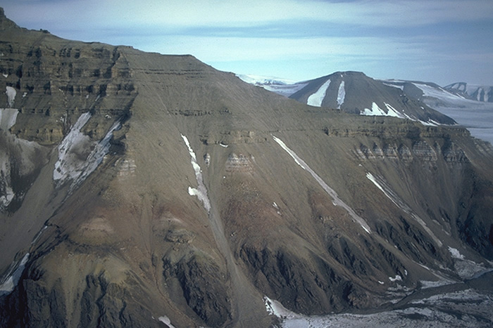
Fig. 2-35: Terrierfjellet (northeastern Bünsow Land), showing Precambrian basement (dark colour) eastward-thinning wedges of Hultberget Formation sandstones (red) and gypsiferous parts of the Ebbadalen Formation (mostly covered) below cliff-forming carbonate rocks of the Minkinfjellet (Terrierfjellet member) and Wordiekammen formations. Photo: E.P. Johannessen CAMPBELLRYGGEN SUBGROUP (CP-24) 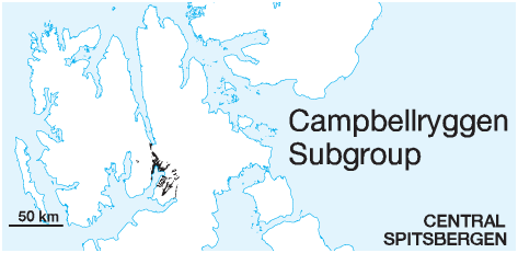 STATUS OF UNIT: Formal
FIRST USE OF NAME: Gee et al. 1952 CURRENT DEFINITION: Here. Rank revised to 'subgroup'. The name was introduced by Gee et al. (1952) as a group name. SYNONYM(S) AND REFERENCE(S): None ORIGIN OF NAME: Campbellryggen: A mountain in NW Bünsow Land, central Spitsbergen TYPE AREA: NE Dickson Land, central Spitsbergen STRUCTURAL SETTING: Billefjorden Trough DEPOSITIONAL AGE: Serpukhovian - early Kasimovian OVERLYING UNIT(S): Dickson Land Subgroup UNDERLYING UNIT(S): Billefjorden Group, locally Pre-Old Red SUPERIOR UNIT: Gipsdalen Group OTHER USE OF NAME: None THICKNESS: Up to 1400 m MAIN LITHOLOGIES: Various carbonate and clastic rocks, evaporites DESCRIPTION: Campbellryggen Subgroup is a collective name for the three formations (Hultberget, Ebbadalen and Minkinfjellet formations) assigned to the roughly Bashkirian to early Kasimovian sedimentary fill of the Billefjorden Trough (Fig. 2-36). For detailed descriptions see the individual formations. 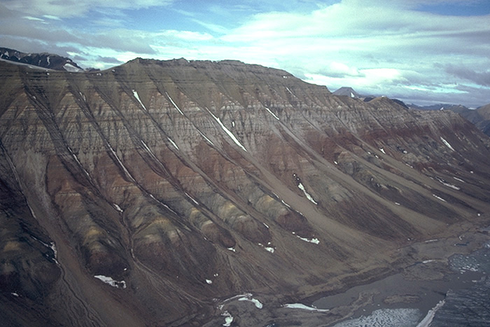
Fig. 2-36: The succession of the Campbellryggen Subgroup of the Billefjorden Trough at Trikolorfjellet (western Dickson Land). The stratigraphy from below is represented by the Hultberget Formation (lowermost redbeds), the Ebbadalen Formation with the multicoloured Ebbaelva Member, the redbeds of the Odellfjellet Member and the light, gypsum-dominated Trikolorfjellet Member. The latter two are interfingering. The mountain is capped by sandy carbonate and carbonate rocks of the Minkinfjellet Formation (upper grey beds). Photo: E.P. Johannessen HULTBERGET FORMATION (CP-25)  DISTRIBUTION shown on Fig. 2-09
STATUS OF UNIT: Formal FIRST USE OF NAME: Cutbill & Challinor 1965 CURRENT DEFINITION: Here Rank revised to 'formation' SYNONYM(S) AND REFERENCE(S): "Hultberget Member": Cutbill & Challinor 1965; "Anservika Member": Gjelberg 1984 (unpubl.) ORIGIN OF NAME: Hultberget: A mountain in NE Dickson Land, central Spitsbergen TYPE SECTION (Fig. 2-38, Fig. 2-39): Unit stratotype: Odellfjellet, NE Dickson Land Boundary stratotype: Anservika, SW Bünsow Land. 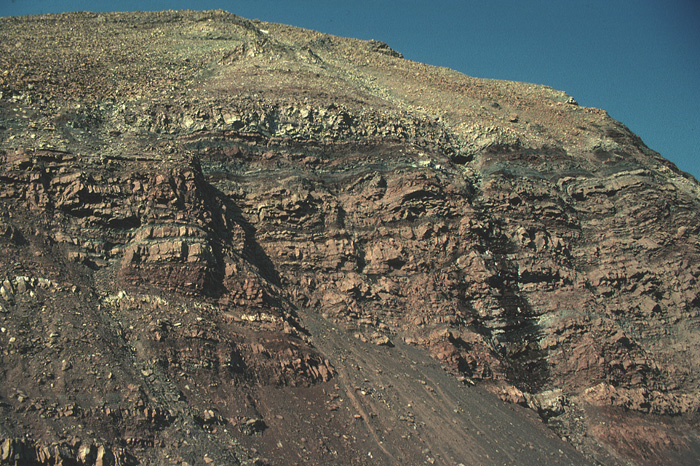
Fig. 2-37: Redbeds of the Hultberget Formation at Odellfjellet (northwestern Dickson Land), overlain by multi-coloured debris of the Ebbaelva Member. Photo: W.K. Dallmann The thickest and most complete section at Odellfjellet is defined as the type section of the Hultberget Formation, though it lacks the basal part of the formation. The Anservika section is therefore used as the boundary stratotype. Because of easier access it may also be used as a reference stratotype. STRUCTURAL SETTING: Billefjorden Trough DEPOSITIONAL AGE: Late Serpukhovian DATING METHOD: Palynology REFERENCE(S) FOR AGE: Playford 1962 OVERLYING UNIT(S): Ebbadalen Formation; locally in easternmost exposures: Minkinfjellet Formation UNDERLYING UNIT(S): Mumien Formation SUPERIOR UNIT: Gipsdalen Group OTHER USE OF NAME: None THICKNESS: Up to 120 m MAIN LITHOLOGIES: Red shale, sandstone, conglomerate 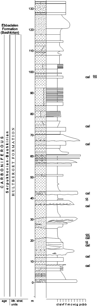
Fig. 2-38: Stratigraphic section CP-25a Unit stratotype for: Hultberget Formation Locality: Odellfjellet Reference: Gjelberg 1984 (unpubl.) LOWER BOUNDARY DEFINITION: The lower boundary (only exposed in Anservika) is sharp and marks a prominent lithological change from coal-bearing, grey sandstones and shales of the Mumien Formation to the non-coal-bearing redbeds of the Hultberget Formation. DESCRIPTION: The "Hultberget Member", originally part of the "Svenbreen Formation", Billefjorden Group (Cutbill and Challinor 1965), was redefined by Johannessen (1980, unpubl.) to include only the upper red-bed, mainly coalbarren part of the unit. It was placed within the Ebbadalen Formation. These Hultberget redbeds are here raised to formation rank (Hultberget Formation), and assigned to the Campbellryggen Subgroup, Gipsdalen Group (Fig. 2-37). 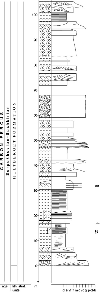
Fig. 2-39: Stratigraphic section CP-25b. Boundary stratotype for: Hultberget Formation. Locality: Anservika. Reference: Gjelberg 1984a (unpubl.), redrawn from Aakvik (unpubl.) The Hultberget Formation consists of alternating red (subordinately grey) shale, sandstone and conglomerate. These are interpreted as ephemeral stream and overbank deposits, partly on alluvial fans which built out from the Billefjorden Fault Zone, interfingering eastwards into alluvial floodplains, lagoons and shoreline deposits. Marine transgressions probably came from the north. A possibly significant age break between the Hultberget Formation and the underlying Billefjorden Group has recently been suggested (Nøttvedt et al. 1992). The boundary would thus be a stratigraphic unconformity. The upper boundary with the Ebbadalen Formation is a transitional or sharp contact with overlying grey sandstones. Back to top EBBADALEN FORMATION (CP-26) 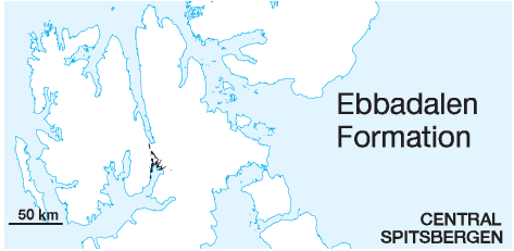 DISTRIBUTION shown on Fig. 2-09
STATUS OF UNIT: Formal FIRST USE OF NAME: Cutbill & Challinor 1965 CURRENT DEFINITION: Cutbill & Challinor 1965 SYNONYM(S) AND REFERENCE(S): "Untere Gipsstufe": Nathorst 1910; "Lower Gypsiferous Series": Gee et al. 1952 ORIGIN OF NAME: Ebbadalen: A glacier valley in NE Dickson Land TYPE SECTION (Fig. 2-41, Fig. 2-42): Stratotype: Wordiekammen, NE Dickson Land (Fig. 2-40). Hypostratotype: Odellfjellet, NE Dickson Land 
Fig. 2-40: Type section of the Ebbadalen Formation at Wordiekammen, Ebbadalen (eastern Dickson Land). The lightcoloured bands are gypsum layers of the Trikolorfjellet Member. Photo: E.P. Johannessen STRUCTURAL SETTING: Billefjorden Trough DEPOSITIONAL AGE: Bashkirian (roughly). Based on brachiopods, Holliday & Cutbill (1972) raised the possibility that the lower part of the Ebbadalen Formation might be of Early Carboniferous (Namurian) age, rather than Bashkirian, as previously supposed (Orvin 1940; Gee et al. 1952; Forbes et al. 1958; Forbes 1960; Cutbill & Challinor 1965). The upper part of the Ebbadalen Formation on Odellfjellet may have a Moscovian age (Johannessen 1980, unpubl.). DATING METHOD: Invertebrate fossils, (foraminifera, brachiopods) REFERENCE(S) FOR AGE: Holliday & Cutbill 1972 OVERLYING UNIT(S): Minkinfjellet Formation; locally ?Wordiekammen Formation UNDERLYING UNIT(S): Hultberget Formation SUPERIOR UNIT: Campbellryggen Subgroup OTHER USE OF NAME: None THICKNESS: 0 to >550 m, 282 m in stratotype MAIN LITHOLOGIES:Wide range of clastics, carbonate rocks and evaporites LOWER BOUNDARY DEFINITION: Grey sandstones of the Ebbaelva Member mark the formational base and rest with a sometimes sharp contact, sometimes with a transitional contact zone on red sandstones and shales of the Hultberget Formation. 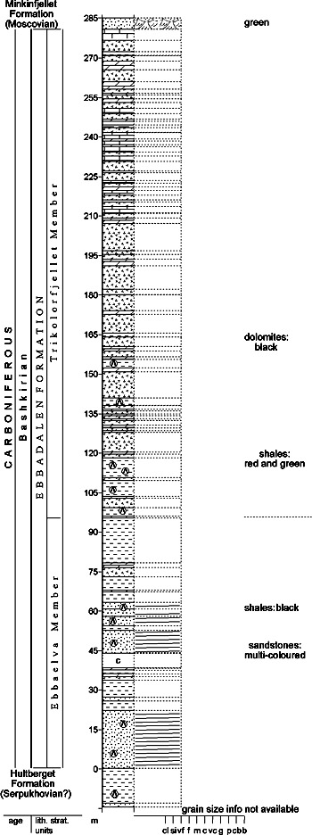
Fig. 2-41: Stratigraphic section CP-26a/29. Stratotype for: Ebbadalen Formation, Trikolorfjellet Member. Locality: Wordiekammen, Ebbadalen. Reference: Holliday & Cutbill 1972 DESCRIPTION: The Ebbadalen Formation lies in an asymmetric, elongate basin (approx. 18 km wide) on the downthrow side of the Billefjorden Fault Zone, the Billefjorden Trough. The unit thins from more than 550 m along the western edge of the trough at Odellfjellet to its pinchout on the eastern basin margin at Terrierfjellet. The facies within the formation are highly variable, both vertically and laterally, and are described in more detail for the individual members. Several workers interpret the base of the Ebbadalen Formation to be an unconformity (Tyrrell 1922; Orvin 1940; Holliday & Cutbill 1972), while others suggest continuous deposition from the underlying Hultberget Formation into the Ebbadalen Formation (Gee et al. 1952; McWhae 1953; Gobbett 1963; Johannessen 1980, unpubl.; Johannessen & Steel 1992). The grey sandstones of the Ebbaelva Member are interbedded with black and green shales. Overlying the Ebbaelva Member occur gypsum, anhydrite and limestones (Trikolorfjellet Member), which pass westward into red shales and red coarse clastics (Odellfjellet Member). The upper contact is transitional in the west, where both Ebbadalen Formation and the overlying Minkinfjellet Formation consist of clastic lithologies (Johannessen & Steel 1992). In the central part of the basin, the contact is easily recognised by a sudden change from the gypsiferous Trikolorfjellet Member to clastic sediments in the lower part of the Minkinfjellet Formation (Holliday & Cutbill 1972). On the eastern basin margin, the boundary is again transitional, where evaporites and black carbonates of the Trikolorfjellet Member grade into evaporitic limestones and grey dolomites ("Urmstonfjellet Limestone Beds", Holliday & Cutbill 1972) of the Minkinfjellet Formation (Lønøy 1995). 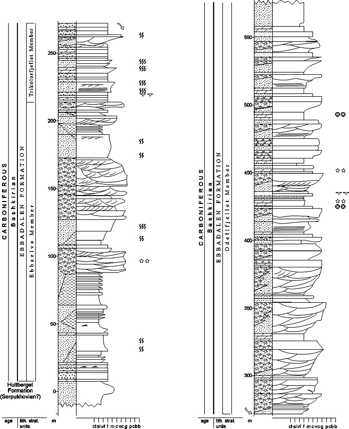
Fig. 2-42: Stratigraphic section CP-26b/28a. Hypostratotype for: Ebbadalen Formation. Stratotype for: Odellfjellet Member. Locality: Odellfjellet. Reference: Johannessen & Steel 1992, from Johannessen 1980 (unpubl.) Depositional environments are lakes, alluvial fans, braided streams, mouth bars, fan deltas, sabkhas, lagoons and shorefaces (Johannessen & Steel 1992). Ebbaelva Member (CP-27) STATUS OF UNIT: Formal FIRST USE OF NAME: Holliday & Cutbill 1972 CURRENT DEFINITION: Johannessen & Steel 1992 SYNONYM(S) AND REFERENCE(S): None ORIGIN OF NAME: Ebbaelva: The main river in the valley Ebbadalen, NE Dickson Land, central Spitsbergen TYPE SECTION (Fig. 2-44): Stratotype: Hultberget, north-eastern Dickson Land DEPOSITIONAL AGE: Bashkirian or slightly older DATING METHOD: Fusulinids REFERENCE(S) FOR AGE: Holliday & Cutbill 1972 OVERLYING UNIT(S): Trikolorfjellet Member, Odellfjellet Member UNDERLYING UNIT(S): Hultberget Formation SUPERIOR UNIT: Ebbadalen Formation OTHER USE OF NAME: None THICKNESS: 0-220 m, 70 m in stratotype MAIN LITHOLOGIES: Sandstone, shale LOWER BOUNDARY DEFINITION: See Ebbadalen Formation DESCRIPTION: The thickness of the Ebbaelva Member varies around 220 m along the western margin of the Billefjorden Trough and the member pinches out on the eastern basin margin at Terrierfjellet. The lower boundary corresponds to the base of the Ebbadalen Formation. The upper boundary is taken at the base of dominant evaporite/carbonate beds. The "Ebbabreen sandstone beds", "Ebbabreen shale beds" and "Gerritelva sandstone member" (Holliday & Cutbill 1972) describe only local facies within the Ebbaelva Member and are not correlated basin-wide (Johannessen 1980, unpubl.). The facies variations within the Ebbaelva Member are highly variable, both vertically and laterally, and are described in detail by Johannessen (1980, unpubl.). The member comprises grey and yellow sandstones interbedded with grey-green shales and minor interbeds of carbonates, evaporites, conglomerates and red sandstones (Fig. 2-43). Depositional environments include lakes, lagoons, sabkhas, braided streams, mouth bars, fan deltas and shorefaces. 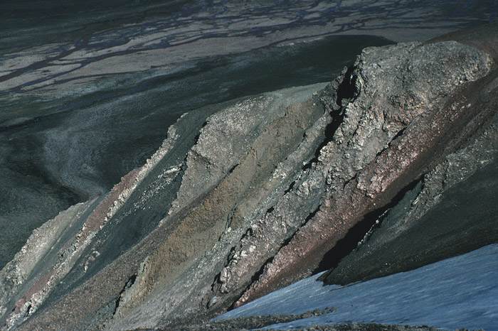
Fig. 2-43: Outcrops of the Ebbaelva Member at the northern slope of Odellfjellet. The multi-coloured succession contains greenish-grey shales, white or pink gypsum, red marls, yellowish silt- and sandstones. Photo: W.K. Dallmann Locally on the southeastern side of the Billefjorden Trough, at the top of the Ebbaelva Member, the "Margaretbreen conglomerate facies" is developed (Holliday & Cutbill 1972; Johannessen 1980, unpubl.). This unit has a thickness variation from 2.5 m to 20 m and comprises yellow sandstones, conglomerates and sandy dolomites with echinoderm fragments. 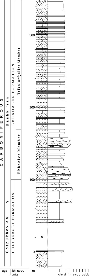
Fig. 2-44: Stratigraphic section CP-27. Stratotype for: Ebbaelva Member. Locality: Hultberget. Reference: Johannessen & Steel 1992, from Johannessen 1980 (unpubl.) Odellfjellet Member (CP-28) STATUS OF UNIT: Formal FIRST USE OF NAME: Johannessen & Steel 1992 CURRENT DEFINITION: Johannessen & Steel 1992 SYNONYM(S) AND REFERENCE(S): "Pyramiden Formation": Ljutkevic 1937b; "Low./Up. redbed facies": Holliday & Cutbill 1972 ORIGIN OF NAME: Odellfjellet: A mountain in NE Dickson Land, central Spitsbergen TYPE SECTION (Fig. 2-42, Fig. 2-46): Stratotype: Odellfjellet, NE Dickson Land. Hypostratotype: Pyramiden, NE Dickson Land DEPOSITIONAL AGE: Bashkirian. The upper part of the Odellfjellet Member on Odellfjellet may have a Moscovian age (Johannessen 1980, unpubl.). DATING METHOD: Fossils in adjacent units REFERENCE(S) FOR AGE: Holliday & Cutbill 1972 OVERLYING UNIT(S): Minkinfjellet Formation; locally ?Wordiekammen Formation UNDERLYING UNIT(S): Ebbaelva Member, Trikolorfjellet Member LATERALLY ADJACENT UNIT(S): Trikolorfjellet Member SUPERIOR UNIT: Ebbadalen Formation OTHER USE OF NAME: None 
Fig. 2-45: Alluvial channel and overbank deposits in the Odellfjellet Member, Odellfjellet (northeastern Dickson Land). Photo: E.P. Johannessen THICKNESS: Up to 400 m MAIN LITHOLOGIES: Multicoloured conglomerate, sandstone and dolomite LOWER BOUNDARY DEFINITION: The lower part of the member interfingers with the carbonate-evaporite-dominated lithologies of the underlying Trikolorfjellet Member. The boundary is defined at the onset of multicoloured, coarse clastic rocks above carbonates and evaporites. DESCRIPTION: The Odellfjellet Member onlaps the faulted basin margin of the Billefjorden Trough in the west (Pyramiden section) and consists of red, grey and yellow conglomerates and sandstones, red shales (locally with gypsum nodules), yellow dolomites and sandy dolomites. 
Fig. 2-46: Stratigraphic section CP-28b. Hypostratotype for: Odellfjellet Member. Locality: Pyramiden. Reference: Johannessen & Steel 1992, from Johannessen 1980 (unpubl.) The member consists of a series of clastic wedges built out from the Billefjorden Fault Zone and has been interpreted largely in terms of alluvial fan (Fig. 2-45), fan delta, shoreline and aeolian deposits. The sediments are arranged in 15-30 m thick coarsening-upward sequences consisting of red alluvial fan sandstones and conglomerates, capped by white quartzitic sandstones and yellow dolomites and limestones. Trikolorfjellet Member (CP-29) STATUS OF UNIT: Formal FIRST USE OF NAME: Holliday & Cutbill 1972 CURRENT DEFINITION: Johannessen & Steel 1992 SYNONYM(S) AND REFERENCE(S): None ORIGIN OF NAME: Trikolorfjellet: A mountain in NE Dickson Land, central Spitsbergen TYPE SECTION (Fig. 2-41): Stratotype: Wordiekammen, NE Dickson Land DEPOSITIONAL AGE: Bashkirian DATING METHOD: Fusulinids REFERENCE(S) FOR AGE: Holliday & Cutbill 1972 OVERLYING UNIT(S): Odellfjellet Member, Minkinfjellet Formation UNDERLYING UNIT(S): Ebbaelva Member LATERALLY ADJACENT UNIT(S): Odellfjellet Member SUPERIOR UNIT: Ebbadalen Formation OTHER USE OF NAME: None THICKNESS: Up to 240 m, 185 m in stratotype MAIN LITHOLOGIES: Carbonate rocks, evaporites LOWER BOUNDARY DEFINITION: The lower boundary is defined where evaporite-carbonate bed alternations start to dominate above the Ebbaelva Member or above interfingering clastic lobes of the Ebbaelva Member. DESCRIPTION: The Trikolorfjellet Member has its greatest thickness (240 m) in the central part of the Billefjorden Trough and thins towards the Billefjorden Fault Zone (5-50 m at Odellfjellet and 0 m at Pyramiden). It interfingers with the Odellfjellet Member (Johannessen 1980, unpubl.). On the eastern basin margin, the Trikolorfjellet Member pinches out at Terrierfjellet. Holliday & Cutbill (1972) reported an overall thickness variation from 150 m to over 400 m because they included both the "Redbed facies" (now Odellfjellet Member) and the "Urmstonfjellet Limestone Bed" (part of Minkinfjellet Formation) in their Trikolorfjellet Member. The Trikolorfjellet Member consists of gypsum/anhydrite (interpreted as sabkha deposits) in alternation with black and minor yellow limestones and dolomites (interpreted as open marine/lagoonal to intertidal deposits) (Fig. 2-47). Red mudstones and minor red sandstones (interpreted as distal alluvial fans), related to the interfingering Odellfjellet Member, occur in western and central areas. 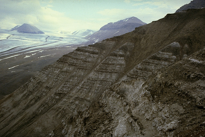
Fig. 2-47: The gypsiferous Trikolorfjellet Member at Cadellfjellet (northern Bünsow Land). Photo: E.P. Johannessen Back to top MINKINFJELLET FORMATION (CP-30)  DISTRIBUTION shown on Fig. 2-09
STATUS OF UNIT: Formal FIRST USE OF NAME: Cutbill & Challinor 1965 CURRENT DEFINITION: Cutbill & Challinor (1965) defined the unit as a member of the "Nordenskiöldbreen Formation". Slightly redefined here. SYNONYM(S) AND REFERENCE(S): "Passage Beds": Gee et al. 1952; "Minkinfjellet Member": Cutbill & Challinor 1965 ORIGIN OF NAME: Minkinfjellet: A mountain in N Bünsow Land TYPE SECTION (Fig. 2-49): Stratotype: Urmstonfjellet W, N Dickson Land. The stratotype was originally defined at the northern face of Minkinfjellet (Cutbill & Challinor 1965), but no documentation is available. The two localities are situated close to each other. STRUCTURAL SETTING: Billefjorden Trough DEPOSITIONAL AGE: Moscovian - early Kasimovian DATING METHOD: Fossils (fusulinids) REFERENCE(S) FOR AGE: Pickard et al. 1996 OVERLYING UNIT(S): Wordiekammen Formation UNDERLYING UNIT(S): Ebbadalen Formation; locally Hultberget Formation or Pre-Old Red LATERALLY ADJACENT UNIT(S): Upper part of Ebbadalen Formation; lower part of Wordiekammen Formation (Pyefjellet Beds) SUPERIOR UNIT: Campbellryggen Subgroup OTHER USE OF NAME: None THICKNESS: Up to 300 m, 246 m in stratotype MAIN LITHOLOGIES: Dolomite, sandstone, gypsum LOWER BOUNDARY DEFINITION: The formation's lower boundary is in most places easily recognisable by a sudden change from the underlying gypsiferous Trikolorfjellet Member of the Ebbadalen Formation into the alternating sediments (dolomites, limestones, sandstones, evaporites) of the Carronelva Member. In eastern areas, the dolomitic rocks of the Terrierfjellet Member overlie sandstones of the Billefjorden Group or folded Pre-Old Red. The boundary is an angular unconformity on a regional scale. DESCRIPTION: The Minkinfjellet Formation forms part of the sedimentary fill of the asymmetric Billefjorden Trough. The strata are exposed to the east of the N-S trending Billefjorden Fault Zone, between Isfjorden and Austfjorden. Thickness values range from 0 m to ca. 300 m, the thickest exposures occur 5-12 km east of the fault zone, north of Petuniabukta. Lithologies are cross-bedded sandstones, limestones, dolomites, carbonate breccias and, subordinate anhydrite/gypsum. Gypsum predominates only in the southern part of Campbellryggen. The Minkinfjellet Formation is characterised by lateral facies changes with interfingering lithologies. The member subdivision reflects specific lithological associations: Carronelva member (clastic and carbonate), Terrierfjellet member (mostly dolomite), Fortet member (mostly carbonate breccia) (Fig. 2-48). For details see these entries. 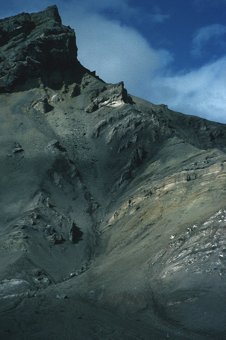
Fig. 2-48: Løvehovden (eastern Dickson Land), showing strata of the Minkinfjellet Formation deformed into a major flexure. To the bottom right, gypsum of the Ebbadalen Formation occurs. The yellowish rocks in the core of the flexure are sandy lithologies of the Carronelva member, while overlying grey dolomites of the Terrierfjellet member turn upwards into dolomite breccias of the Fortet member. The uppermost cliff is formed by the Black Crag Beds of the Wordiekammen Formation. Photo: W.K. Dallmann The upper boundary of the Minkinfjellet Formation is always marked by the characteristic lithologies of the overlying Cadellfjellet Member of the Wordiekammen Formation. The eastern boundary is placed at the lateral transition into limestone-dominated carbonates of the open platform facies of the Wordiekammen Formation. A formational boundary is not obvious in this area, and the eastern limit is arbitrarily defined at the glacier Tunabreen. The relative continuity with the Wordiekammen Formation in these eastern reaches was probably the reason for the grouping of the Minkinfjellet beds with the "Nordenskiöldbreen Formation" (Cutbill & Challinor 1965; see Section 2.3.2). Depositional settings are dominated by restricted peritidal, including sabkha, to shallow subtidal environments. Periodically, conditions were semi-restricted to open marine. Intermittent subaerial exposure with palaeokarst formation occurred. Solution collapse of peritidal deposits in the northwestern part of Bünsow Land caused by the influence of meteoric waters formed the breccias of the Fortet member (Lønøy 1995). 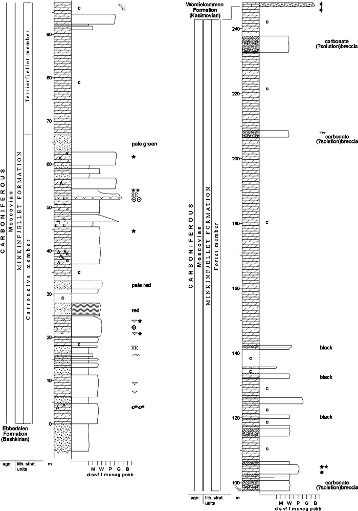
Fig. 2-49: Stratigraphic section CP-30/31a. Stratotype for: Minkinfjellet Formation, Carronelva member. Locality: Urmstonfjellet W. Reference: Lønøy, A. (unpubl.) Carronelva member (CP-31) STATUS OF UNIT: Informal FIRST USE OF NAME: Cutbill & Challinor 1965 CURRENT DEFINITION: Cutbill & Challinor 1965. Raised to 'member' rank here SYNONYM(S) AND REFERENCE(S): "Carronelva Beds": Cutbill & Challinor 1965 ORIGIN OF NAME: Carronelva: A river between the mountains Teltfjellet and Urmstonfjellet (type sections) TYPE SECTION (Fig. 2-49, Fig. 2-50): Stratotype: Urmstonfjellet W, northern Bünsow Land Hypostratotype: Teltfjellet, NW Bünsow Land DEPOSITIONAL AGE: Early Moscovian DATING METHOD: Fossils (not documented), stratigraphic relationships REFERENCE(S) FOR AGE: Cutbill & Challinor 1965 OVERLYING UNIT(S): Terrierfjellet Member UNDERLYING UNIT(S): Ebbadalen Formation SUPERIOR UNIT: Minkinfjellet Formation OTHER USE OF NAME: None THICKNESS: 0 - >100 m, 67 m in stratotype MAIN LITHOLOGIES: Carbonate rocks, sandstone, gypsum LOWER BOUNDARY DEFINITION: See Minkinfjellet Formation DESCRIPTION: The Carronelva member forms the lower part of the Minkinfjellet Formation in the Billefjorden Trough. The base is defined at the transition from the evaporitedominated Trikolorfjellet Member to a carbonate-dominated succession. Minor evaporitic sequences also occur within the Carronelva member in the southern part of Campbellryggen. The top is defined at the top of the uppermost massive sandstone. The member underlies the breccias of the Fortet member in northwestern parts of the exposure area (Petuniabukta), and the carbonate rocks of the Terrierfjellet member elsewhere. Lithologies are alternating dolomites, limestones, sandstones and evaporites. Limestones are most common in the southeastern part of Bünsow Land. Dolomites are generally unfossiliferous and some have a characteristic yellow weathering surface. The gypsum content decreases upwards in the sequence and southeastwards in Bünsow Land. Sandstones are red, green or yellow and are very fine- to coarsegrained. At Ebbabreen and Ragnarbreen, the member starts with coarse clastic rocks at the base (polymict sedimentary breccias with a carbonate matrix, "Ragnarbreen Breccia", McWhae 1953). These basal beds pinch out westwards, where they are replaced by greenish to yellowish mediumgrained sandstones (western half of Sfinksen, Løvehovden and Wordiekammen). The overlying succession consists of yellowish sandstones, partly with a distinct sulphurous smell. Shales, marls, limestones and sandy limestones with gypsum vugs are intercalated in the upper part, where lithologies of the Terrierfjellet and Carronelva members interfinger. 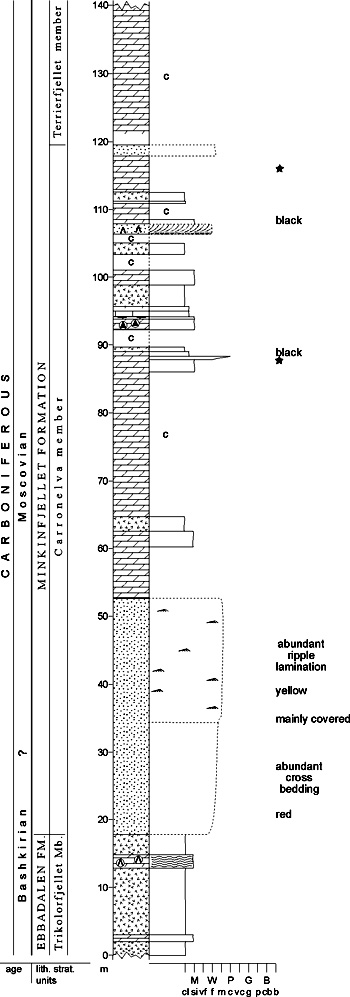
Fig. 2-50: Stratigraphic section CP-31b. Hypostratotype for: Carronelva member. Locality: Teltfjellet NW. Reference: Lønøy, A. (unpubl.) The Carronelva member was deposited in peritidal to shallow subtidal environments. Restricted, periodically hypersaline marine settings in the northern part of Bünsow Land, grade southwards into mixed restricted and open marine settings. Intermittent subaerial exposure with karst formation occurred. The lower part of the member represents the eastward extension of the upper Trikolorfjellet Member, Ebbadalen Formation. It is equivalent to the "Lower" and "Middle" units of Lønøy (1995). Terrierfjellet member (CP-32) STATUS OF UNIT: Informal FIRST USE OF NAME: Here CURRENT DEFINITION: Here SYNONYM(S) AND REFERENCE(S): None ORIGIN OF NAME: Terrierfjellet: A nunatak close to the type section, in the middle of the glacier Nordenskiöldbreen TYPE SECTION: Stratotype: Urmstonfjellet E, northern Bünsow Land DEPOSITIONAL AGE: Moscovian - early Kasimovian DATING METHOD: Fossils (not documented), stratigraphic relationships REFERENCE(S) FOR AGE: Cutbill & Challinor 1965 OVERLYING UNIT(S): Wordiekammen Formation, locally Fortet member UNDERLYING UNIT(S): Carronelva member; locally Hultberget Formation or Pre-Old Red LATERALLY ADJACENT UNIT(S): Wordiekammen Formation, Malte Brunfjellet Formation, Fortet member SUPERIOR UNIT: Minkinfjellet Formation OTHER USE OF NAME: None THICKNESS: Up to 300 m MAIN LITHOLOGIES: Carbonate rocks, gypsum LOWER BOUNDARY DEFINITION: The base of the Terrierfjellet member is defined at the onset of an almost purely carbonate succession defining the member, overlying the uppermost massive sandstone bed of the underlying Carronelva member. DESCRIPTION: The Terrierfjellet member consists of dolomites and subordinate limestones, as well as fine-grained limestone conglomerates. It is dominated by mudsupported textures and is commonly unfossiliferous, although the minor fossil content increases northeastwards. Bituminous laminae are abundant in the southeastern part of Bünsow Land. The eastern limit is represented by the lateral transition towards limestone-dominated successions of the Wordiekammen Formation (see Minkinfjellet Formation). In places, the member comprises most of the basin succession, e.g. on Minkinfjellet, Terrierfjellet and Flemingfjellet, although thin clastic beds of the Carronelva member may underlie it. In eastern areas, the carbonate rocks are interbedded with marls or marly limestones which often give the succession a distinctly stratified appearance. In western areas, they are more massive and rich in flint concretions or flintstone intercalations, as at Petuniabukta. A few gypsum beds are intercalated in their lower part at Petuniabukta, but these rapidly pinch out to the east. Foraminifera have been described by Sosipatrova (1967), while brachiopods, corals, bryozoans and molluscs have been reported by others (Gee et al. 1952; Gramberg et al. 1990, Dallmann & Mørk 1991). Beds with crinoid debris are found on Trikolorfjellet. The Terrierfjellet member is equivalent to the "Upper unit" of Lønøy (1995), excluding the northwestern dolomite breccia (Fortet member), and to the "Anservika Member" of Dallmann (1993). Most of the member is generally screecovered. Restricted marine deposits dominate in Bünsow Land, but become more open marine eastwards in Sabine Land (Lønøy 1995). Fortet member (CP-33) STATUS OF UNIT: Informal FIRST USE OF NAME: McWhae 1953 CURRENT DEFINITION: Dallmann 1993 SYNONYM(S) AND REFERENCE(S): "Cyathophyllum Limestones Breccia": Gee et al. (1952); "Fortet Breccia": McWhae 1953 ORIGIN OF NAME: Fortet (transl. "The Castle"): A mountain edge at the SW corner of the mountain Wordiekammen, NE Bünsow Land TYPE LOCALITY: Fortet, NE Dickson Land DEPOSITIONAL AGE: Moscovian - early Kasimovian DATING METHOD: Fossils in adjacent units, stratigraphic relationships REFERENCE(S) FOR AGE: Cutbill & Challinor 1965 OVERLYING UNIT(S): Wordiekammen Formation UNDERLYING UNIT(S): Terrierfjellet member LATERALLY ADJACENT UNIT(S): Terrierfjellet member SUPERIOR UNIT: Minkinfjellet Formation OTHER USE OF NAME: None THICKNESS: Up to 240 m MAIN LITHOLOGIES: Dolomite breccia LOWER BOUNDARY DEFINITION: First appearance of brecciated dolomites. The boundary is transitional; lithologies interfinger with those of the Terrierfjellet member. DESCRIPTION: The Fortet member is characterised by a carbonate breccia occurring in the northwestern part of Bünsow Land. The breccias grade southwards into evaporites and eastwards into dolomites, both assigned to the Terrierfjellet member. Breccia clasts range in diameter from a few cm to more than a metre (occasionally) and form high breccia porosity. The member is extensively scree-covered. The breccias may locally represent in-situ brecciated bedrock, but consist of distinctly transported clasts in other places. Both grain-supported and matrix-supported varieties occur, with a micritic carbonate matrix. The rocks show different degrees of cementation, so that well-cemented parts tend to form cliffs and pinnacles, while the surrounding material is removed by erosion (Fig. 2-51). The exposures on the southern side of Fortet, near Rudmosepynten, are well suited as a type section for the Fortet member, though it has not been logged. In this locality the member is ca. 240 m thick, which is approximately its maximum observed thickness. 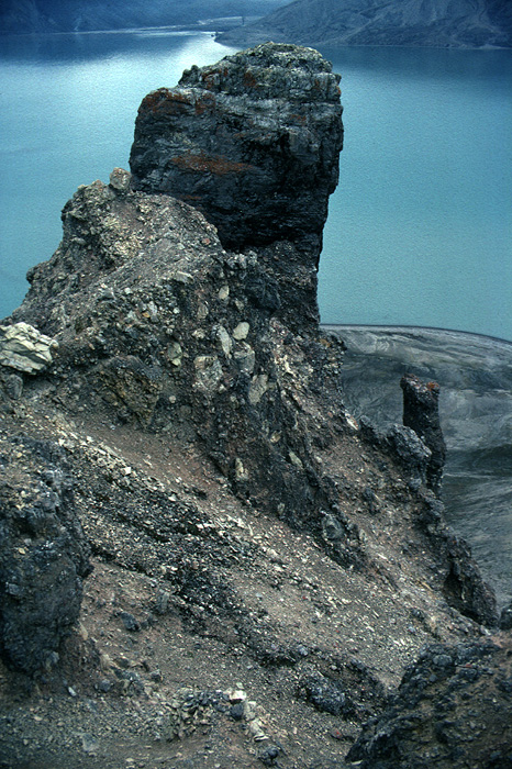
Fig. 2-51: The dolomite breccias of the Fortet member form peculiar pinnacles and towers on the mountain sides at Petuniabukta, here at Fortet. Photo: W.K. Dallmann Different explanations have been indicated for the origin of the breccia, including solution collapse (McWhae 1953; Sundsbø 1982, unpubl.; Lønøy 1995), subsurface sliding associated with late Jurassic faulting (Cutbill & Challinor 1965), and synsedimentational earthquake activity (Dallmann 1993). Back to top CHARLESBREEN SUBGROUP (CP-34)  STATUS OF UNIT: Formal
FIRST USE OF NAME: Dineley 1958 CURRENT DEFINITION: Here; rank revised to 'subgroup'. The name was introduced by Dineley (1958) as a group name. SYNONYM(S) AND REFERENCE(S): None ORIGIN OF NAME: Charlesbreen: A glacier in Oscar II Land, central western Spitsbergen TYPE AREA: St. Jonsfjorden area, central western Spitsbergen STRUCTURAL SETTING: St. Jonsfjorden Trough DEPOSITIONAL AGE: Bashkirian - Moscovian OVERLYING UNIT(S): Dickson Land Subgroup UNDERLYING UNIT(S): Billefjorden Group, locally Pre-Old Red SUPERIOR UNIT: Gipsdalen Group OTHER USE OF NAME: None THICKNESS: Up to ca. 650 m MAIN LITHOLOGIES: Conglomerate, sandstone, shale DESCRIPTION: Charlesbreen Subgroup is a collective name for the four formations (Brøggertinden, Scheteligfjellet, Petrellskaret and Tårnkanten formations) assigned to the (roughly) Bashkirian-Moscovian fill of the St. Jonsfjorden Trough. See the individual formations. The subgroup shows a stratigraphic development from redbed to carbonate environments (Fig. 2-52). 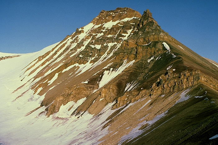
Fig. 2-52: The mountain Tårnkanten near St. Jonsfjorden, showing the Charlesbreen Subgroup of the St. Jonsfjorden Trough with the shalesandstone succession of the Petrellskaret Formation and the overlying, sandstone-dominated Tårnkanten Formation. Photo: E.P. Johannessen Fig. 2-53: A fluvial conglomerate with intervening, crossbedded sandstones from the Brøggertinden Formation. Type section at Brøggerfjellet. Photo: P. Ludwig BRØGGERTINDEN FORMATION (CP-35) 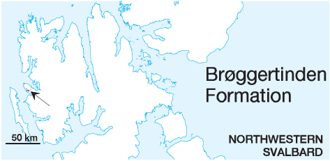 DISTRIBUTION shown on Fig. 2-08
STATUS OF UNIT: Formal FIRST USE OF NAME: Cutbill & Challinor 1965 CURRENT DEFINITION: Cutbill & Challinor 1965 SYNONYM(S) AND REFERENCE(S): None ORIGIN OF NAME: Brøggertinden: Highest peak of Brøggerfjellet, Brøggerhalvøya TYPE SECTION (Fig. 2-54): Stratotype: Brøggerfjellet S, Brøggerhalvøya STRUCTURAL SETTING: St. Jonsfjorden Trough DEPOSITIONAL AGE: Bashkirian (upper part of formation). Earlier suggestions: Early Carboniferous (Holtedahl 1913); Devonian (Orvin 1934, based on poorly preserved fish fragments) DATING METHOD: Fossils, e.g. conodonts* REFERENCE(S) FOR AGE: Cutbill & Challinor 1965 (no documentation); *Buggisch et al. (in press) OVERLYING UNIT(S): Scheteligfjellet Formation UNDERLYING UNIT(S): Pre-Old Red, Orustdalen Formation SUPERIOR UNIT: Charlesbreen Subgroup OTHER USE OF NAME: None THICKNESS: 13-360 m, ca. 355 m in stratotype (?max. 290 m according to Ludwig 1991, unpubl.) MAIN LITHOLOGIES: Conglomerate, sandstone, shale LOWER BOUNDARY DEFINITION: The Brøggertinden Formation rests unconformably on folded Precambrian basement, locally on sandstones of the Orustdalen Formation. 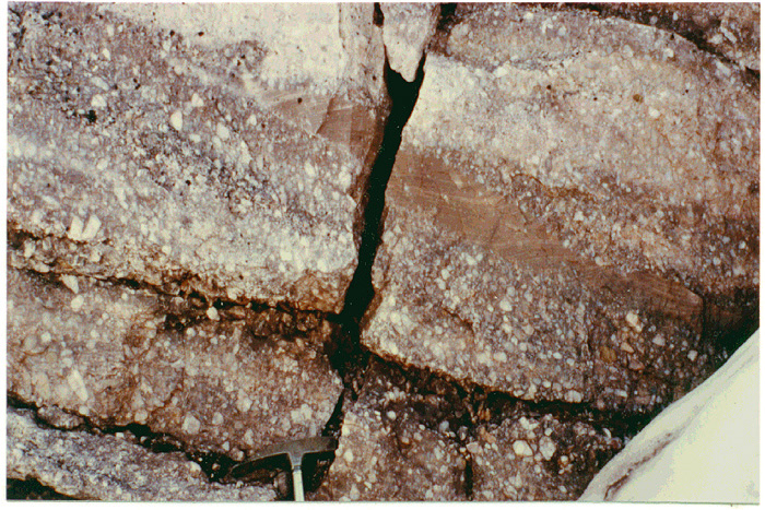
Fig. 2-53: A fluvial conglomerate with intervening, crossbedded sandstones from the Brøggerinden Formation> type section at Brøggerfjellet. Photo: P. Ludwig. DESCRIPTION: The Brøggertinden Formation comprises red, yellow and brown conglomerates, red (some white and grey) micaceous sandstones and red sandy shales in frequent alternations. The upper part is less conglomeratic and thin limestones are interbedded with the clastic sediments. The sediments probably represent arid alluvial fan systems which, according to Barbaroux (1967), built out towards the west (Fig. 2-53). The upper boundary is defined by the transition into the thick limestones of the Scheteligfjellet Formation. 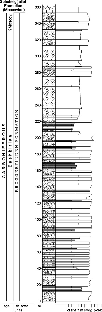
Fig. 2-54: Stratigraphic section CP-35. Stratotype for: Brøggertinden Formation. Locality: Brøggerfjellet S. Reference: Gjelberg 1984 (unpubl.), redrawn from Orvin 1934 Back to top SCHETELIGFJELLET FORMATION (CP-36) 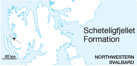 DISTRIBUTION shown on Fig. 2-08
STATUS OF UNIT: Formal FIRST USE OF NAME: Cutbill & Challinor 1965 CURRENT DEFINITION: Here SYNONYM(S) AND REFERENCE(S): Cutbill & Challinor (1965) defined the unit as a member of the "Nordenskiöldbreen Formation". ORIGIN OF NAME: Scheteligfjellet: A mountain on Brøggerhalvøya TYPE SECTION (Fig. 2-56): Stratotype: Traudalen, Brøggerhalvøya. The stratotype was originally defined at northeastern Scheteligfjellet (Cutbill & Challinor 1965), but no documentation is available. STRUCTURAL SETTING: St. Jonsfjorden Trough DEPOSITIONAL AGE: Early - Middle Moscovian DATING METHOD: Fossils, e.g. fusulinids REFERENCE(S) FOR AGE: Holtedahl 1911, 1913; Cutbill & Challinor 1965 (no documentation); Buggisch et al. (in press) OVERLYING UNIT(S): Wordiekammen Formation UNDERLYING UNIT(S): Brøggertinden Formation SUPERIOR UNIT: Charlesbreen Subgroup OTHER USE OF NAME: None THICKNESS: 0-120 (?150) m, 105 m in stratotype MAIN LITHOLOGIES: Carbonate rocks, calcareous sandstone, conglomerate and sedimentary breccia LOWER BOUNDARY DEFINITION: The boundary of the carbonate-dominated Scheteligfjellet Formation with the underlying red clastics of the Brøggertinden Formation is an interfingering surface. The boundary is defined at the onset of dominant carbonate lithologies in each place. On NW Brøggerhalvøya, a 5-10 m thick, polymict conglomerate with a yellowish, dolomitic matrix, infilling topographic relief in the Orustdalen Formation, constitutes the underlying Brøggertinden Formation. Where present, a bluish-grey Multithecopora (coral) limestone bed, which is lithologically distinctive, is defined as the basal layer of the Scheteligfjellet Formation (Ludwig 1991, unpubl.; Fig. 2-55). It may locally be replaced by reef facies limestones (Kiærstranda). 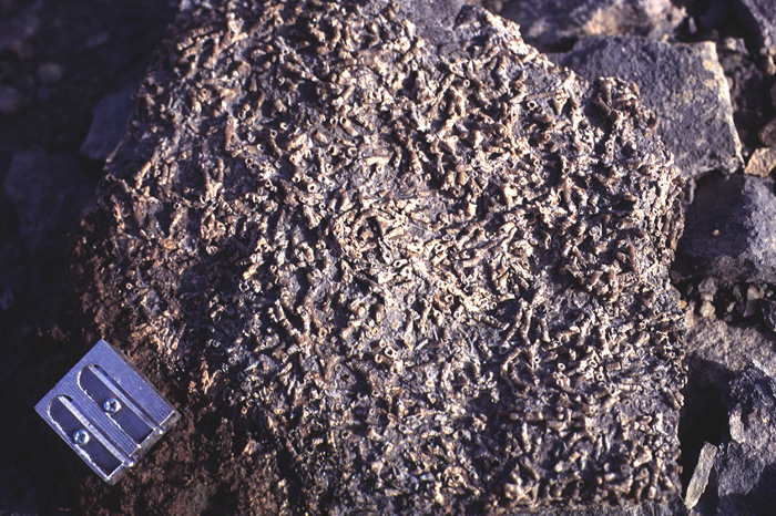
Fig. 2-55: A multithecopore limestone typical for the Scheteligfjellet Formation, here photographed in the basal part of the type section in Traudalen. Similar multithecopore colonies have also been observed in the Wordiekammen Formation. Photo: K. Saalmann DESCRIPTION: The main lithology consists of grey or dark grey micrites or biomicrites (interpreted as shelf carbonates), often interbedded with greenish-grey or reddish calcareous sandstone, siltstone and shale. Yellow-weathering dolomites occur, and occasionally conglomerates. A 2-3 m coral biostrome is locally observed above the basal conglomerate. Intraformational or solution breccias, up to 50 m thick, with fragments (MPS 10 cm) of grey and yellow dolomite and limestone, are also observed. The carbonate rocks contain white or yellow cherty nodules and calcite- or quartz-filled vugs. The formation contains abundant marine fauna, including brachiopods, fusulinids, corals, crinoids and bryozoans, less frequently gastropods, trilobites, ostracods and fish remains. Especially in the lower parts of the formation, many fossils are preserved in red chert; chert may also occur in nodules and thin layers. The upper boundary is transitional to the pure carbonates of the Mørebreen Member. It is taken at the first appearance of massive, thick, grey limestones with a distinct content of silica/dolomite nodules typical for the Wordiekammen Formation. Locally, e.g. at Strypbekken, the first massive beds containing abundant silica nodules are dolomites, which then define the formation boundary. Above the boundary, no more siliciclastic beds occur (Saalmann 1995, unpubl.; Sidow 1988, unpubl.). 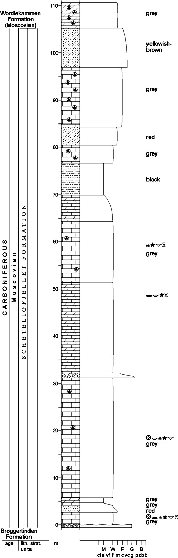
Fig. 2-56: Stratigraphic section CP-36. Stratotype for: Scheteligfjellet Formation. Locality: Traudalen. Reference: Saalmann, K. 1995 (unpubl.) Back to top PETRELLSKARET FORMATION (CP-37)  DISTRIBUTION shown on Fig. 2-07, Fig. 2-08
STATUS OF UNIT: Formal FIRST USE OF NAME: D.L. Dineley in: Gobbett 1963 CURRENT DEFINITION: Cutbill & Challinor 1965 SYNONYM(S) AND REFERENCE(S): "Petrelskardet Shale Formation": Cutbill & Challinor (1965) ORIGIN OF NAME: Petrellskaret (transl. "Petrel Notch": A mountain saddle in the Vegardfjella massif, inner St. Jonsfjorden. Until 1991, the place name was only known from the geological literature. The Place Name Committee for Svalbard accepted the place name in 1991 to allow formal use of the formation name, but with the Nynorsk spelling (Petrellskaret) obligatory for place names in Svalbard. type section (Fig. 2-57): Unit stratotype: Petrellskaret, Vegardfjella STRUCTURAL SETTING: St. Jonsfjorden Trough DEPOSITIONAL AGE: ?Bashkirian DATING METHOD: Indirect from fossil age of underlying and overlying formations REFERENCE(S) FOR AGE: Cutbill & Challinor 1965 OVERLYING UNIT(S): Tårnkanten Formation UNDERLYING UNIT(S): Vegardfjella Formation SUPERIOR UNIT: Charlesbreen Subgroup OTHER USE OF NAME: None THICKNESS: ca. 360 m in type area MAIN LITHOLOGIES: Interbedded shales and sandstones, predominantly red-coloured LOWER BOUNDARY DEFINITION: No exposure of the lower boundary has been found, but there is suggested a conformable contact on thinly bedded sandstones and shales of the Vegardfjella Formation (Dineley 1958). 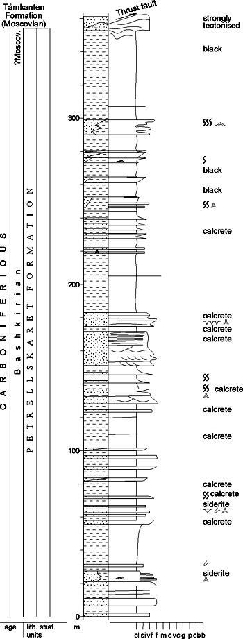
Fig. 2-57: Stratigraphic section CP-37. Unit stratotype for: Petrellskaret Formation. Locality: Petrellskaret, Vegardfjella. Reference: Gjelberg 1984 DESCRIPTION: The Petrellskaret Formation consists mainly of red and black/grey shales, interstratified with thin, red, grey and white sandstone beds and red calcretes. The only prominent sandstone horizon (7 to 20 m thick beds) occurs in the middle of the formation. The upper part of the formation shows a very thick accumulation of black shales. Thin evaporite and limestone beds are present in the lower part of the red shale succession, while in the black shales at the top of the formation, a bone-bed horizon has been observed. The boundary with the overlying Tårnkanten Formation is conformable, and no major time-break appears between the two formations. The stratigraphic contact between the formations is, however, not exposed at the type locality because of small thrust faults. The boundary is placed at the base of cliffforming thick sandstones of the Tårnkanten Formation. The various lithofacies are interpreted as fluvial channel sandstones, red fine-grained floodplain and coastal plain deposits. Black shales and fine-grained sandstones were deposited in lagoons, bays or lakes (?). Back to top TÅRNKANTEN FORMATION (CP-38)  DISTRIBUTION shown on Fig. 2-08
STATUS OF UNIT: Formal FIRST USE OF NAME: Dineley 1958 CURRENT DEFINITION: Cutbill & Challinor 1965 SYNONYM(S) AND REFERENCE(S): None ORIGIN OF NAME: Tårnkanten (transl. "Tower Edge": A mountain edge in the Vegardfjella massif, inner St. Jonsfjorden. TYPE SECTION (Fig. 2-58): Stratotype: Tårnkanten, Vegardfjella STRUCTURAL SETTING: St. Jonsfjorden Trough DEPOSITIONAL AGE: Early - Middle Moscovian DATING METHOD: Fossils, mainly brachiopods. Two marine bands comprising black shales with grey argillaceous and fossil rich limestones are interbedded with the Tårnkanten sandstones. The fauna consists of abundant spiriferid and stropheodontid brachiopods, but other brachiopods, small pelecypods, corals and a single trilobite have also been found. The brachiopods correlate closely with those of the Scheteligfjellet Formation, suggesting that the Tårnkanten Formation probably is of Early and Middle Moscovian age (Gobbett 1963). REFERENCE(S) FOR AGE: Gobbett 1963 OVERLYING UNIT(S): Wordiekammen Formation UNDERLYING UNIT(S): Petrellskaret Formation SUPERIOR UNIT: Charlesbreen Subgroup OTHER USE OF NAME: None THICKNESS: 247 m in stratotype MAIN LITHOLOGIES: Multicoloured sandstone succession with interbedded shales, intercalated carbonate beds in upper part LOWER BOUNDARY DEFINITION: The stratigraphic contact between the Petrellskaret and Tårnkanten formations is normally not exposed because of small thrust faults, but seems to be conformable. The boundary is placed at the base of cliff-forming thick sandstones of the Tårnkanten Formation over the shale-dominated underlying succession. 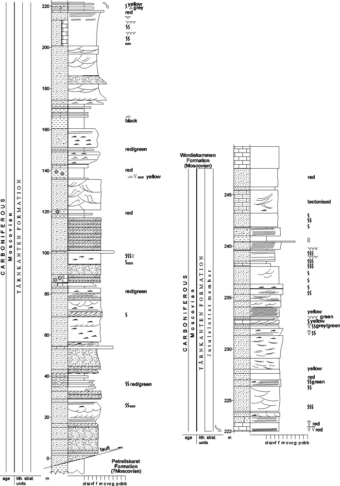
Fig. 2-58: Stratigraphic section CP-38. Stratotype for: Tårnkanten Formation. Locality: Tårnkanten Vegardfjella. Reference: Johannessen, Gjelberg and Olaussen, in Johannessen et al. 1984 (unpubl.) DESCRIPTION: Lithologies are multicoloured (red, grey, green, yellow, white) sandstones and minor conglomerates, interbedded with red shales containing calcareous nodules and black shales with thin limestone beds. These black bands are fossil-rich marker beds and separate the formation into at least three sections. The special development of the Jutulslottet member (upper part of the formation) comprises yellow dolomitic sandstones and dolomite-limestone beds. The boundary with the overlying Wordiekammen Formation is a sharp lithological break. The contact at the type locality in Vegardfjella is a thrust fault plane. The upper part of the formation, the Jutulslottet member, is apparently much thinner here than at its type locality at Jutulslottet. The depositional environments were intertidal to deltaic, comprising braided stream channels, mouth bars, lagoons, tidal flats, beaches, marine sands (?tidal) and open marine black shales and carbonates. Increasing marine influence is suggested in upper parts of the formation. Jutulslottet member (CP-39) STATUS OF UNIT: Informal FIRST USE OF NAME: Here, after Johannessen et al. 1984 (unpubl.) CURRENT DEFINITION: Here SYNONYM(S) AND REFERENCE(S): None ORIGIN OF NAME: Jutulslottet (transl. "The Giant Castle"): A nunatak in Oscar II Land, south of St. Jonsfjorden TYPE SECTION (Fig. 2-60): Stratotype: Jutulslottet, Inner St. Jonsfjorden, Oscar II Land DEPOSITIONAL AGE: Early - Middle Moscovian DATING METHOD: Fossils, mainly brachiopods. See Tårnkanten Formation REFERENCE(S) FOR AGE: Gobbett 1963 OVERLYING UNIT(S): Wordiekammen Formation UNDERLYING UNIT(S): Tårnkanten Fm., lower part SUPERIOR UNIT: Tårnkanten Formation OTHER USE OF NAME: None THICKNESS: Up to 100 m MAIN LITHOLOGIES: Multicoloured sandstones and subordinate shales, intercalated carbonate beds LOWER BOUNDARY DEFINITION: The lower boundary is transitional, from the thickly bedded sandstones in the lower part of the Tårnkanten Formation to the thinner sandstone beds, interbedded with carbonates and thin shale beds of the Jutulslottet member. The boundary is placed at about 150 m level in the type section at Jutulslottet. DESCRIPTION: The Jutulslottet member comprises multicoloured (red, grey, yellow, white) sandstones and dolomitic sandstones, interbedded with red and black shales as well as grey, black and yellow limestones and dolomites (Fig. 2-59). 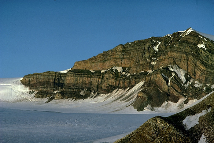
Fig. 2-59: The mountain Jutulslottet near St. Jonsfjorden, showing the carbonate-bearing upper part of the sandstone-dominated Tårnkanten Formation, the Jutulslottet Member, reflecting the initial marine influence in this part of the St. Jonsfjorden Trough. Photo: E.P. Johannessen The upper boundary is not exposed in the type locality at Jutulslottet. At Vegardfjella, the boundary is a thrust contact. The depositional environment reflects rapidly interchanging shallow marine carbonates, (?tidal) sandstones, lagoons and shoreface sections with delta plain to distal alluvial fan deposits, including paleosols. The lower half of the nunatak Jutulslottet (lower part of Tårnkanten Fm.) has not yet been logged, and a correlation between the Tårnkanten and Jutulslottet sections is questionable. Different levels of thrusting complicate a possible correlation. The member therefore has informal status. 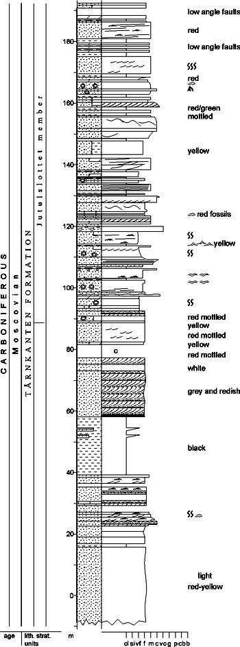
Fig. 2-60: Stratigraphic section CP-39. Stratotype for: Jutulslottet member. Locality: Jutulslottet. Reference: Johannessen et al. 1984 (unpubl.) Back to top TRESKELEN SUBGROUP (CP-40) 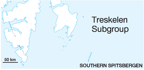 STATUS OF UNIT: Formal
FIRST USE OF NAME: Here CURRENT DEFINITION: Here SYNONYM(S) AND REFERENCE(S): None ORIGIN OF NAME: Treskelen (transl. "The Threshold"): A peninsula in the inner part of Hornsund TYPE AREA: Inner Hornsund, southern Spitsbergen STRUCTURAL SETTING: Inner Hornsund Trough DEPOSITIONAL AGE: Bashkirian - Early Permian OVERLYING UNIT(S): Dickson Land Subgroup, Tempelfjorden Group; locally on Sørkapp-Hornsund High: Sassendalen Group UNDERLYING UNIT(S): Billefjorden Group, locally Pre-Old Red SUPERIOR UNIT: Gipsdalen Group OTHER USE OF NAME: None THICKNESS: Up to 750 m MAIN LITHOLOGIES: Conglomerate, sandstone, subordinate shale DESCRIPTION: Treskelen Subgroup is a collective name for the two formations (Hyrnefjellet and Treskelen fms.) assigned to the Bashkirian-Early Permian fill of the Inner Hornsund Trough (Fig. 2-61). See the individual formations. 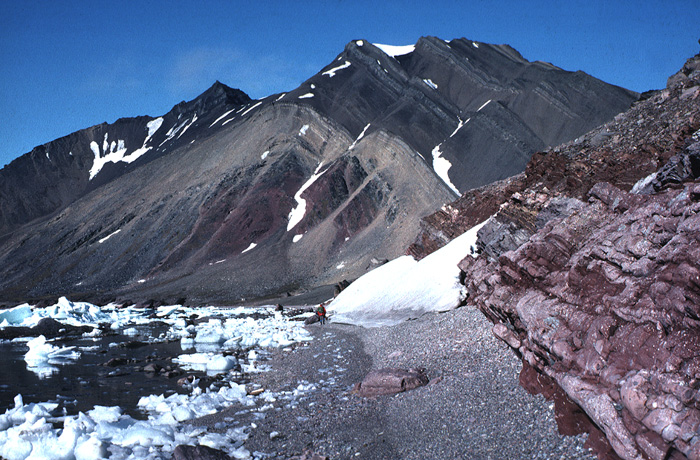
Fig. 2-61: The mountain Hyrnefjellet at Hornsund, showing the folded Treskelen Subgroup of the Inner Hornsund Trough with the redbeds of the Hyrnefjellet Formation and the calcareous clastics of the Treskelodden Formation. Photo: W.K. Dallmann Back to top HYRNEFJELLET FORMATION (CP-41) 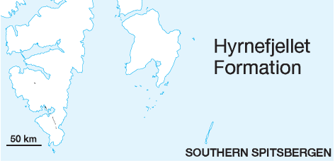 DISTRIBUTION shown on Fig. 2-06, Fig. 2-07
STATUS OF UNIT: Formal FIRST USE OF NAME: Birkenmajer 1959 CURRENT DEFINITION: Birkenmajer 1964 SYNONYM(S) AND REFERENCE(S): Hyrnefjellet "beds": Birkenmajer 1959, 1964. The unit was first ranked as a formation by Cutbill & Challinor (1965). ORIGIN OF NAME: Hyrnefjellet (transl. "Corner Mountain"): A mountain at the northern side of the inner part of Hornsund, southern Spitsbergen TYPE SECTION (Fig. 2-63): Stratotype: Hyrnefjellet South, Adriabukta STRUCTURAL SETTING: Inner Hornsund Trough DEPOSITIONAL AGE: Bashkirian - Moscovian (?Kasimovian) DATING METHOD: Indirect. The age is interpreted by correlation with synsedimentational tectonism suggested from facies development. The overlying Treskelodden Formation contains latest Carboniferous and Early Permian fossils. REFERENCE(S) FOR AGE: Gjelberg & Steel 1981 OVERLYING UNIT(S): Treskelodden Formation; locally on Sørkapp-Hornsund High: Vardebukta Formation UNDERLYING UNIT(S): Adriabukta Formation, Hornsundneset Formation, ?Sergeijevfjellet Formation, Pre-Old Red SUPERIOR UNIT: Treskelen Subgroup OTHER USE OF NAME: "Hyrnefjellet Formation" (Pčelina 1983): Part of the Triassic Bravaisberget Formation (M-19) THICKNESS: Up to 600 m, ca. 235 m in stratotype MAIN LITHOLOGIES: Conglomerates and sandstones, predominantly red LOWER BOUNDARY DEFINITION: South of Hornsund, the base is marked by the prominent change from grey quartzites and dark grey shales of the Billefjorden Group to red and multicoloured clastics of the Hyrnefjellet Formation. North of Hornsund, similar multicoloured clastics of the Hyrnefjellet Formation overlie grey shales and sandstones of the folded Adriabukta Formation with an angular unconformity. DESCRIPTION: The Hyrnefjellet Formation occurs along the West Spitsbergen Foldbelt from north of Hornsund to Mønsåsen on Sørkappfonna. Stratigraphic and lithological descriptions have been published previously only from north of Hornsund, where the formation is ca. 270 m thick, and where only the upper member is present. The thickness reaches more than 600 m at Knattberget and Hjelmen, where a preliminary subdivision into three members, the Hjelmen, Brattberget and Bladegga members, is made. North of Hornsund, exposures of the Hyrnefjellet Formation (270 m) seem to belong entirely to the Brattberget member. The predominant lithologies in the type area (Hyrnefjellet and Treskelen) are red, frequently graded gravel- to bouldersize conglomerates. They may form channel fills and laterally interfinger with sandstones. The matrix is sandy with detrital micas. Light, fairly well-sorted, medium-grained quartzitic sandstones occur in places. South of Hornsund, a grey, unstructured conglomerate with angular to subangular quartz, quartzite and subordinate chert boulders occurs (Bladegga member). At the lowermost stratigraphic level, also south of Hornsund, multicoloured sandstones with occasional shales or conglomerates (Hjelmen member) occur (Fig. 2-62). 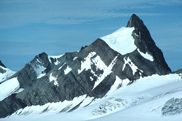
Fig. 2-62: Carboniferous succession at the mountain Hjelmen ("The Helmet") Sørkapp Land. Grey sandstones of the Hornsundneset Formation build up the lower half of the exposed strata, while the higher levels show the Hjelmen member (multi-coloured clastic rocks below the large snow field) and the conglomeratic Brattberget member (summit and right part of mountain) of the Hyrnefjellet Formation. Photo: W.K. Dallmann The facies of the Hyrnefjellet Formation – at least the Brattberget member – reflect alluvial, distributary channel and interdistributary bay (overbank deposits) environments (Birkenmajer 1984a). Climatic conditions were warm and arid. All detrital material is derived from nearby source rocks (Siedlecka 1968), i.e. the Proterozoic basement, Devonian and Early Carboniferous sedimentary rocks of the Samarinbreen area. The sudden upward coarsening at the base of the Brattberget and Bladegga members is thought to indicate synsedimentational fault activity along the Inner Hornsund Fault Zone (Gjelberg & Steel 1981). 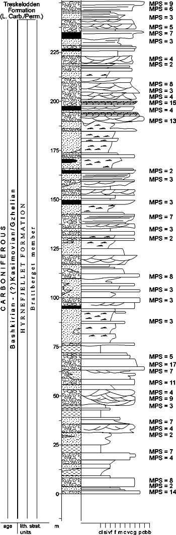
Fig. 2-63: Stratigraphic section CP-41/43. Stratotype for: Hyrnefjellet Formation, Brattberget member. Locality: Hyrnefjellet S. Reference: Gjelberg & Steel 1981 Hjelmen member (CP-42) STATUS OF UNIT: Informal FIRST USE OF NAME: Dallmann et al. 1993 CURRENT DEFINITION: Dallmann et al. 1993 SYNONYM(S) AND REFERENCE(S): None ORIGIN OF NAME: Hjelmen (transl. "The Helmet"): A nunatak in Sørkapp Land TYPE LOCALITY: Hjelmen, Sørkapp Land DEPOSITIONAL AGE: Bashkirian - Moscovian DATING METHOD: Indirect, stratigraphic relationships. See Hyrnefjellet Formation REFERENCE(S) FOR AGE: Gjelberg & Steel 1981 OVERLYING UNIT(S): Brattberget member UNDERLYING UNIT(S): Hornsundneset Formation SUPERIOR UNIT: Hyrnefjellet Formation OTHER USE OF NAME: None THICKNESS: ca. 100 m MAIN LITHOLOGIES: Multicoloured sandstones LOWER BOUNDARY DEFINITION: See Hyrnefjellet Formation, south of Hornsund. 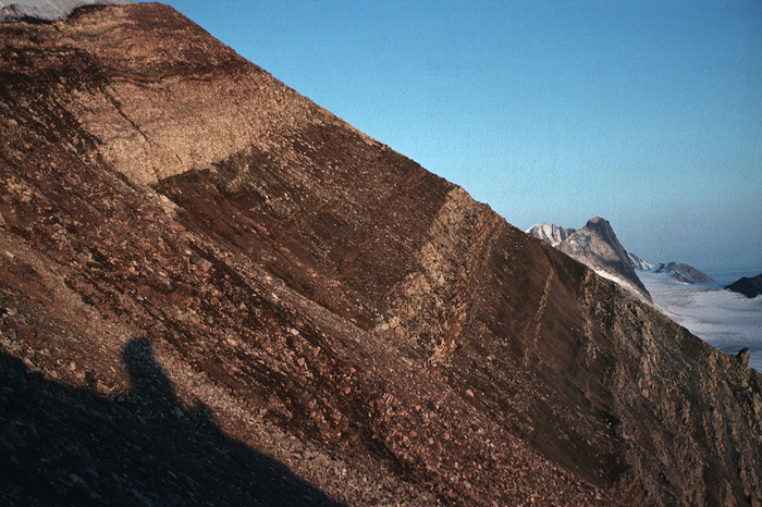
Fig. 2-64: The multicoloured clastic succession of the Hjelmen member on the western slope of the mountain Hjelmen (Sørkapp Land), mainly composed of red and grey sandstones, light quartzites and pinkish sedimentary breccias. Photo: W.K. Dallmann DESCRIPTION: The Hjelmen member consists of multicoloured sandstones, with subordinate beds of pebble conglomerates and sedimentary breccias. The best accessible section is at Hjelmen, where it is ca. 100 m thick (Fig. 2-64). It thins northward and pinches out at Tsjernajafjellet, while the southernmost exposure has been observed on the southern ridge of Knattberget. Different sandstone varieties alternate: 1. Coarse- to medium-grained, red, texturally and compositionally immature sandstones with a hematite matrix, occasionally with pebbles of sedimentary, probably Devonian, rocks; 2. medium- to fine-grained, light grey or white, impure quartzites with an irregular cross lamination, abundant zircon grains and, locally, a secondary lamination of hematite matrix or a spotted appearance by weathered aggregates of iron minerals; 3. very fine-grained, grey, immature sandstones with cross-lamination and wave ripple marks; 4. sedimentary breccias with a pink, immature sandstone matrix and pebbles of sedimentary rocks (some are sandstones of the Adriabukta Formation); 5. fine-grained, red, immature, carbonate-cemented sandstones with scattered grains of fine quartz gravel (Knattberget). Brattberget member (CP-43) STATUS OF UNIT: Informal FIRST USE OF NAME: Dallmann et al. 1993 CURRENT DEFINITION: Dallmann et al. 1993 SYNONYM(S) AND REFERENCE(S): None ORIGIN OF NAME: Brattberget (transl. "Steep Rock"): A nunatak in Sørkapp Land TYPE SECTION (Fig. 2-63): Stratotype: Hyrnefjellet South, Adriabukta, Hornsund DEPOSITIONAL AGE: Bashkirian - Moscovian (?Kasimovian) DATING METHOD: Indirectly from stratigraphic relations. See Hyrnefjellet Formation REFERENCE(S) FOR AGE: Gjelberg & Steel 1981 OVERLYING UNIT(S): Treskelodden Formation UNDERLYING UNIT(S): Bladegga or Hjelmen members, Adriabukta Formation, Hornsundneset Formation, Pre-Old Red SUPERIOR UNIT: Hyrnefjellet Formation OTHER USE OF NAME: None THICKNESS: Up to 425 m, ca. 235 m in stratotype MAIN LITHOLOGIES: Red conglomerates and subordinate sandstones LOWER BOUNDARY DEFINITION: See Hyrnefjellet Formation, north of Hornsund. South of Hornsund, there is a distinct onset of coarse, red conglomerates above the finer-grained lithologies of the other members of the Hyrnefjellet Formation. DESCRIPTION: The Brattberget member occurs along the entire outcrop of the Hyrnefjellet Formation, extending from north of Hornsund (northernmost exposure at Zittelberget, Dallmann et al. 1990), to Mønsåsen on Sørkappfonna. Thickness values range from ca. 350 m at Brattberget, ca. 425 m at Knattberget to ca. 275 m at Steinhatten. The unit passes laterally into the Bladegga member (see below) in the Chomjakovbreen area. Lithologies are mainly gravel- to boulder-size conglomerates, clast-supported, red (rarely grey or very light) and frequently graded (single or multiple). They may form channel fills and laterally interfinger with sandstones (Fig. 2-65). The matrix is sandy with detrital micas. The rocks are often silica-cemented. The boulders or pebbles are angular to subangular and consist of vein quartz and feldspar as well as metamorphic quartzites of many colours, cherts, red, grey and multicoloured sandstones (probably derived partly from the Hjelmen member and lower parts of the Brattberget member). Sandstone boulders are confined to coarse, red conglomerates, while fine-grained conglomerates and gritstones have quartzitic pebbles. 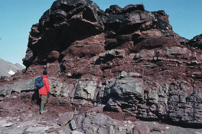
Fig. 2-65: A typical detail of the Brattberget member, consisting of red, coarse, alluvial fan conglomerates (upper cliff), light and grey sandstones and red siltstones (overbank deposits). Adriabukta, Hornsund. Photo: W.K. Dallmann Many of the sandstones are also texturally and compositionally immature, red or grey, with mixed silica, ferruginous, chlorite and, occasionally, carbonate cements. Scattered quartz gravel or pebbles occur. Light, fairly well-sorted, medium-grained quartzitic sandstones occur in places. Bladegga member (CP-44) STATUS OF UNIT: Informal FIRST USE OF NAME: Gjelberg & Steel 1981 CURRENT DEFINITION: Here SYNONYM(S) AND REFERENCE(S): Bladegga "Formation": Gjelberg 1984 (unpubl.) ORIGIN OF NAME: Bladegga (transl. "The Blade Edge"): A nunatak in Sørkapp Land TYPE SECTION (Fig. 2-66): Stratotype: Bladegga, Sørkapp Land DEPOSITIONAL AGE: Bashkirian - Moscovian (exact age very uncertain) DATING METHOD: Indirect, stratigraphic relationships. See Hyrnefjellet Formation REFERENCE(S) FOR AGE: Gjelberg & Steel 1981 OVERLYING UNIT(S): Brattberget member, Vardebukta Formation UNDERLYING UNIT(S): Hornsundneset Formation, locally ?Sergeijevfjellet Formation SUPERIOR UNIT: Hyrnefjellet Formation OTHER USE OF NAME: None THICKNESS: Up to >350 m, ca. 260 m in stratotype MAIN LITHOLOGIES: Conglomerates LOWER BOUNDARY DEFINITION: See Hyrnefjellet Formation, south of Hornsund. At Bladegga (type section), the base of the Bladegga member is defined at the base of massive, light-coloured, quartzitic sandstones that are not typical for other members of the Hyrnefjellet Formation. 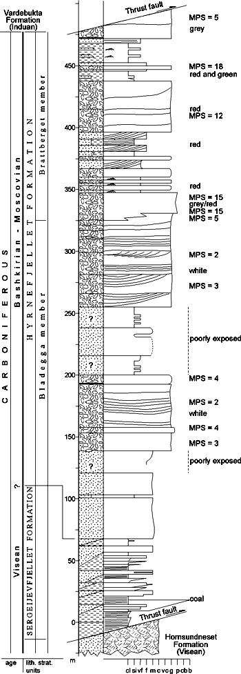
Fig. 2-66: Stratigraphic section CP-44. Stratotype for: Bladegga member. Locality: Bladegga. Reference: Gjelberg 1984 (unpubl.) DESCRIPTION: Most of the Bladegga member is a grey, mostly unstructured conglomerate with angular to subangular quartz, quartzite and subordinate chert boulders of up to 30 cm size. It is at least 350 m thick at Mannsfeldkammen (Bautaen) where it laterally replaces the Brattberget member. The two members are observed to interfinger at Meranpynten and Konglomeratodden (a peninsula east of Meranpynten), which results in intercalated sandstones. The Bladegga member thins at Bladegga below the Brattberget member and pinches out farther south. Both Bautaen and Bladegga form spectacular mountain crests that illustrate the weathering properties of this lithology. Back to top TRESKELODDEN FORMATION (CP-45) 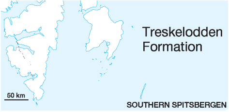 DISTRIBUTION shown on Fig. 2-06, Fig. 2-07
STATUS OF UNIT: Formal FIRST USE OF NAME: Birkenmajer 1959 CURRENT DEFINITION: Birkenmajer 1964 SYNONYM(S) AND REFERENCE(S): Treskelodden "beds": Birkenmajer 1959, 1964. The unit was first ranked as a formation by Cutbill & Challinor (1965). ORIGIN OF NAME: Treskelodden (transl. "Threshold Point"): A cape at the southern end of the Treskelen peninsula, inner Hornsund, southern Spitsbergen TYPE SECTION (Fig. 2-68): Stratotype: Treskelen, creek IV STRUCTURAL SETTING: Inner Hornsund Trough DEPOSITIONAL AGE: Latest Carboniferous to Early Permian DATING METHOD: Fossils, mainly brachiopods and foraminifera REFERENCE(S) FOR AGE: Liszka 1964; Birkenmajer & Czarniecki 1960 OVERLYING UNIT(S): Gipshuken Formation, Kapp Starostin Formation; locally on Sørkapp-Hornsund High: Vardebukta Formation UNDERLYING UNIT(S): Hyrnefjellet Formation; locally Pre-Old Red SUPERIOR UNIT: Treskelen Subgroup OTHER USE OF NAME: None THICKNESS: Up to 185 m, 98 m in stratotype MAIN LITHOLOGIES: Carbonate-cemented pebble conglomerates and sandstones LOWER BOUNDARY DEFINITION: The lower boundary is defined at the distinct onset of carbonate-cemented, yellowish and grey coloured, clastic lithologies above the redbeds of the Hyrnefjellet Formation. DESCRIPTION: The Treskelodden Formation occurs from Bellsund to Hornsund, is absent at Chomjakovbreen south of Hornsund (Fig. 2-61), but can be traced through a few exposures from Tsjernajafjellet southward to Knattberget in Sørkapp Land. The thickness is 185 m at Triasnuten, ca. 100 m at Hyrnefjellet and Treskelen, and 115 m at Austjøkultinden (Fig. 2-67). Detailed descriptions of the formation are published from north of Hornsund (Birkenmajer 1964, 1984b; Czarniecki 1966, 1969; Siedlecka 1968; Fedorowski 1982). 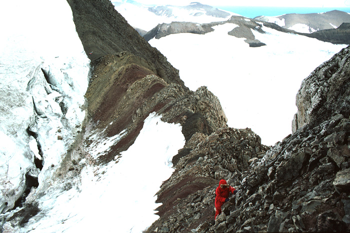
Fig. 2-67: The Treskelodden Formation at Austjøkultinden (Sørkapp Land): Calcite-cemented, yellowish sandstones and conglomerates interbedded with red shales. Hyrnefjellet Formation conglomerates in the foreground, Triassic deposits in the background. Photo: W.K. Dallmann The sediment types are alternating quartz sandstones (mostly calcareous), gravelstones and pebble conglomerates (Fig. 2-67). Sandstones are usually sorted to well-sorted and are both texturally and compositionally more mature than those of the underlying Hyrnefjellet Formation. Gravelstones often show graded bedding, and multiply graded units may have either fining- or coarsening-upward trends. Conglomerates form irregularly shaped beds and are poorly sorted. Ripple marks, cross bedding, erosional unconformities and small channels are frequently observed, and mud cracks occur. An interesting phenomenon is the presence of up to five coral horizons on Treskelen, partly within intercalated dolostones and limestones. The only investigated section south of Hornsund (Austjøkultinden) shows only the uppermost of these. Both colonial and solitary rugose and tabulate corals occur, as well as sponges, foraminifera, brachiopods, crinoids, bryozoans, molluscs and trilobite fragments. The fauna has been studied by Birkenmajer & Czarniecki (1960) and Czarniecki (1966, Late Carboniferous brachiopods), Liszka (1964, Early Permian foraminifera), Fedorowski (1964, 1965, 1967, rugose corals), Osmуlska (1968, trilobites), Birkenmajer (1979b, rugose corals), Karczewski (1982, molluscs), and Nowinski (1982, tabulate corals). Siedlecka (1968) and Birkenmajer (1984b) pointed out a distinct "cyclicity" (rhythmicity) of the succession. With the exception of the lower alluvial cycle, the facies passes repeatedly from shallow marine to lagoonal and alluvial environments (Birkenmajer 1984b). Czarniecki (1966, 1969), however, regarded the formation as entirely marine. Fedorowski (1982) discussed the distinctive redeposited nature of the coral clasts in terms of synsedimentational tectonism along basinal margins. 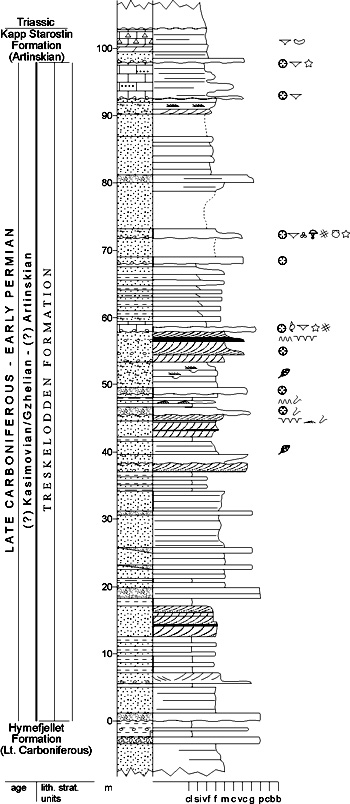
Fig. 2-68: Stratigraphic section CP-45. Stratotype for: Treskelodden Formation. Locality: Treskelen, "creek IV". Reference: Birkenmajer 1984b Back to top DICKSON LAND SUBGROUP (CP-46) 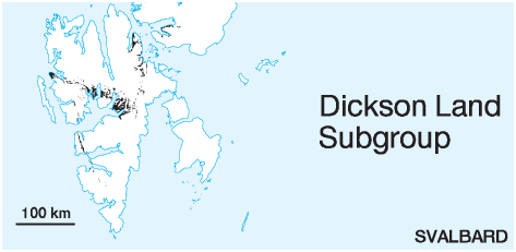 STATUS OF UNIT: Formal
FIRST USE OF NAME: Here CURRENT DEFINITION: Here SYNONYM(S) AND REFERENCE(S): None ORIGIN OF NAME: Dickson Land: The land area between Billefjorden and Dicksonfjorden, central Spitsbergen TYPE AREA: Dickson Land and Bünsow Land, central Spitsbergen STRUCTURAL SETTING: Late Palaeozoic platform of Svalbard/Barents Sea Shelf DEPOSITIONAL AGE: Early Moscovian to Artinskian OVERLYING UNIT(S): Tempelfjorden Group UNDERLYING UNIT(S): Malte Brunfjellet or Hårbardbreen formations, Campbellryggen, Charlesbreen or Treskelen subgroups, Billefjorden or Andrée Land groups, Pre-Old Red SUPERIOR UNIT: Gipsdalen Group OTHER USE OF NAME: None THICKNESS: Up to 500 m MAIN LITHOLOGIES: Carbonate rocks and subordinate evaporites DESCRIPTION: Dickson Land Subgroup is a collective name for the two upper formations of the Gipsdalen Group, the Wordiekammen and Gipshuken formations, that are not deposited in individual troughs. The sediments of the subgroup show distinct overlap with the intertrough highs and progressively develop upwards into a laterally continuous shelf sequence. WORDIEKAMMEN FORMATION (CP-47)  DISTRIBUTION shown on Fig. 2-07, Fig. 2-08, Fig. 2-09, Fig. 2-10
STATUS OF UNIT: Formal FIRST USE OF NAME: Gee et al. 1952 CURRENT DEFINITION: Here. The formation constitutes the upper and main part of the former "Nordenskiöldbreen Formation", which overlies and onlaps both troughs and highs of mid-Carboniferous age. Lower, trough-bound members of the "Nordenskiöldbreen Formation" are raised to formation status (Minkinfjellet and Scheteligfjellet formations), while the remaining platform succession is referred to the Wordiekammen Formation in the sense of Gee et al. (1952). SYNONYM(S) AND REFERENCE(S): Wordiekammen limestones: Gee et al. 1952 ORIGIN OF NAME: Wordiekammen: A mountain east of Billefjorden, central Spitsbergen TYPE AREA: Dickson Land and Bünsow Land, central Spitsbergen STRUCTURAL SETTING: Late Palaeozoic platform of Svalbard/Barents Sea Shelf DEPOSITIONAL AGE: Early Moscovian - Sakmarian DATING METHOD: Fossils, mainly fusulinids REFERENCE(S) FOR AGE: Cutbill & Challinor 1965 (no documentation); Nilsson 1988 (unpubl.) OVERLYING UNIT(S): Gipshuken Formation UNDERLYING UNIT(S): Malte Brunfjellet, Hårbardbreen, Treskelodden, Tårnkanten, Scheteligfjellet or Minkinfjellet formations, Billefjorden or Andrée Land groups, Pre-Old Red SUPERIOR UNIT: Dickson Land Subgroup OTHER USE OF NAME: None THICKNESS: Up to ca. 350 m MAIN LITHOLOGIES: Carbonate rocks LOWER BOUNDARY DEFINITION: In Bünsow Land, the base of the Wordiekammen Formation is defined at the change from a dolomite-dominated (Minkinfjellet Formation) to a limestone-dominated succession. In the western part of the Billefjorden Trough this coincides with the base of the Black Crag Beds, a prominent, dark-coloured limestone unit (see there). Further east, in the Gipsdalen area, it marks the onset of stacked marine limestone intervals with phylloid algal build-ups (Pyefjellet Beds; Pickard et al. 1996), and this sequence is probably situated at a lower level than the Black Crag Beds. In Sabine Land and Ny Friesland, where the Minkinfjellet Formation is absent, the base is defined at the onset of platform carbonates over Pre-Old Red or other Carboniferous, predominantly clastic lithologies (Malte Brunfjellet Formation and its probable equivalents). For more exact local definitions of the formational base see Mørebreen, Kapitol, Cadellfjellet and Idunfjellet members. DESCRIPTION: The Wordiekammen Formation comprises a mainly marine limestone succession (Fig. 2-69). Lithologies are dominant limestones, especially in western areas alternating with dolomites. In western areas there are also subordinate, partly arenaceous or silicified, dolomitic sandstones and grey shales, defining the transitional lower part of the unit. The rocks are fossiliferous, with an abundant fusulinid microfauna and corals, crinoids, bryozoans, brachiopods, sponges, conodonts and ostracods. Bituminous matter, trace fossils and bioturbation are common. A wide range of carbonate build-ups is present, including bryozoan build-ups, phylloid algal build-ups and palaeoaplysinid build-ups. 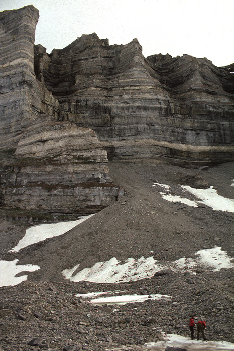
Fig. 2-69: The cliffforming shelf limestones and dolomites of the Wordiekammen Formation make up numerous steep mountain walls on central Spitsbergen, here at Langtuna (Tunabreen, northwestern Sabine Land). Photo: W.K. Dallmann The Wordiekammen Formation was mostly deposited in open to semi-restricted shallow subtidal marine and restricted intertidal to supratidal environments. Mørebreen Member (CP-48) STATUS OF UNIT: Formal FIRST USE OF NAME: Cutbill & Challinor 1965 CURRENT DEFINITION: Here SYNONYM(S) AND REFERENCE(S): None ORIGIN OF NAME: Mørebreen: A glacier on Brøggerhalvøya, probably named after Møre, a coastal region in the middle part of Norway TYPE SECTION (Fig. 2-70): Stratotype: Strypbekken, Brøggerhalvøya DEPOSITIONAL AGE: ?Moscovian - Gzhelian DATING METHOD: Indirect, stratigraphic relationships. REFERENCE(S) FOR AGE: Cutbill & Challinor 1965 OVERLYING UNIT(S): Tyrrellfjellet Member UNDERLYING UNIT(S): Scheteligfjellet Formation SUPERIOR UNIT: Wordiekammen Formation OTHER USE OF NAME: None THICKNESS: 159 m in stratotype MAIN LITHOLOGIES: Limestone, dolomite LOWER BOUNDARY DEFINITION: The member shows a transition with the underlying Scheteligfjellet Formation. Its base is arbitrarily defined at the first appearance of massive, thick, grey limestones with a distinct content of silica/dolomite nodules typical of the Wordiekammen Formation, and above the uppermost, multicoloured sand- and siltstones of the Scheteligfjellet Formation. Locally, e.g. at Strypbekken, the first massive carbonate beds containing abundant nodules are dolomites, which then define the formational base. DESCRIPTION: The Mørebreen Member forms the lower part of the Wordiekammen Formation in the St. Jonsfjorden Trough area. The Mørebreen Member has only been described from Brøggerhalvøya; almost no data about the facies and subdivisions of the Wordiekammen Formation in the St. Jonsfjorden area are found in the geological literature. The Mørebreen Member is an alternating succession of yellow-weathering dolomites and various limestone types (fossiliferous wackestones, packstones and grainstones). Fossil-rich horizons are almost confined to wackestones and packstones in the lower to middle part. Concentric, sparitic dolomite and silica concretions, white, yellow or black, occur abundantly in the dolomites. Limestones show varying degrees of silicification. Limestone breccias occur at a few levels within the middle and upper parts of the formation. Algal build-ups have been described from SE Scheteligfjellet (Sidow 1988, unpubl.; Saalmann 1995, unpubl.). 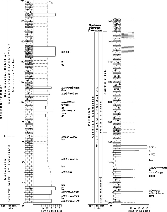
Fig. 2-70: Stratigraphic section CP-48/58. Stratotype for: Mørebreen Member, Kiærfjellet beds. Locality: Strypbekken. Reference: Sidow 1988 (unpubl.) The upper boundary with the Tyrrellfjellet Member coincides with the base of the Brucebyen Beds (see there). Where the Brucebyen Beds are lacking or indistinctly developed (northern part of Brøggerhalvøya), the boundary is poorly expressed, but it is defined by the base of a dark grey to black limestone with dolomite veins (possibly replacing the Brucebyen beds), stratigraphically situated above the upper of two limestone breccias in the type section. It is followed by a monotonous, alternating succession of limestones and dolomites, each a few metres thick (Sidow 1988, unpubl.; Saalmann 1995, unpubl.). Kapitol Member (CP-49) STATUS OF UNIT: Formal FIRST USE OF NAME: Cutbill & Challinor 1965 CURRENT DEFINITION: Cutbill & Challinor 1965 SYNONYM(S) AND REFERENCE(S): None ORIGIN OF NAME: Kapitol: A mountain between Dicksonfjorden and Ekmanfjorden (James I Land), central Spitsbergen TYPE SECTION (Fig. 2-71): Stratotype: Trollfuglfjella, Dicksonfjorden, James I Land. The stratotype was originally defined at the northern ridge of the mountain 'Kapitol' (Cutbill & Challinor 1965), but no documentation is available. DEPOSITIONAL AGE: Early Moscovian - Gzhelian DATING METHOD: Fusulinids REFERENCE(S) FOR AGE: Cutbill & Challinor 1965 (no documentation); Nilsson 1988, 1993 (both unpubl.) OVERLYING UNIT(S): Tyrrellfjellet Member UNDERLYING UNIT(S): Hultberget Formation, Billefjorden Group, Andrée Land Group SUPERIOR UNIT: Wordiekammen Formation OTHER USE OF NAME: None THICKNESS: 20-125 m, 73 m in stratotype MAIN LITHOLOGIES: Limestone, subordinate dolomite LOWER BOUNDARY DEFINITION: The lower boundary of the Kapitol Member is defined by a distinct angular unconformity, where the member overlies folded Devonian clastic rocks. Where clastic rocks of the Billefjorden Group or the Hultberget Formation underlie the Kapitol Member, the lower boundary is defined by a distinct onset of carbonate rocks, which also form prominent cliffs in the mountain sides. 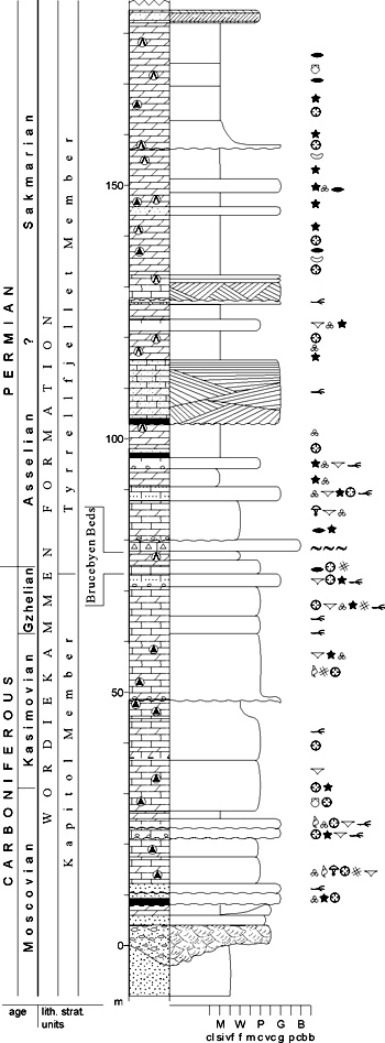
Fig. 2-71: Stratigraphic section CP-49. Stratotype for: Kapitol Member. Locality: Trollfuglfjella. Reference: Nilsson 1993 (unpubl.) based on Skaug 1982 (unpubl.) and Dons 1983 (unpubl.) DESCRIPTION: The Kapitol Member forms the lower part of the Wordiekammen Formation on the Nordfjorden High. It consists of dolomites and limestones, with a thin siliciclastic basal succession; this comprises some few cm to metres of mica-rich, red and green coloured, locally conglomeratic transgressive sandstones. Dominant limestone types are packstone and grainstone (Dons 1983, unpubl.). The sediments were mainly deposited on a shallow, open marine, high-energy platform during the progressive transgression of the Nordfjorden High from the west-southwest (Dons 1983, unpubl.). The depositional area was periodically subaerially exposed. Cadellfjellet Member (CP-50) STATUS OF UNIT: Formal FIRST USE OF NAME: Cutbill & Challinor 1965 CURRENT DEFINITION: Cutbill & Challinor 1965 SYNONYM(S) AND REFERENCE(S): None ORIGIN OF NAME: Cadellfjellet: A mountain east of Billefjorden, central Spitsbergen TYPE SECTION: Stratotype: Boltonbreen, Bünsow Land. The stratotype was originally defined at the western ridge of Cadellfjellet (Cutbill & Challinor 1965), but no documentation is available. DEPOSITIONAL AGE: Late Moscovian - late Gzhelian DATING METHOD: Fusulinids REFERENCE(S) FOR AGE: Nilsson 1993 (unpubl.) OVERLYING UNIT(S): Tyrrellfjellet Member UNDERLYING UNIT(S): Minkinfjellet Formation, Malte Brunfjellet Formation SUPERIOR UNIT: Wordiekammen Formation OTHER USE OF NAME: None THICKNESS: 90-250 m MAIN LITHOLOGIES: Limestone, dolomite LOWER BOUNDARY DEFINITION: In Bünsow Land, the base of the Cadellfjellet Member is defined at the transition from a dolomite-dominated (Minkinfjellet Formation) to a limestone-dominated succession. In the western part of the Billefjorden Trough this coincides with the base of the Black Crag Beds, a prominent, dark-coloured limestone unit (see there). Further east, in the Gipsdalen area, it marks the onset of stacked marine limestone intervals with phylloid algal build-ups (Pyefjellet Beds; Pickard et al. 1996), and this succession is probably situated at a lower level than the Black Crag Beds. In Sabine Land and Ny Friesland, where the Minkinfjellet Formation is absent, the base is defined at the onset of platform carbonates over the Hecla Hoek basement or predominantly clastic lithologies (Malte Brunfjellet Formation and its probable equivalents). DESCRIPTION: The Cadellfjellet Member forms the lowermost part of the Wordiekammen Formation in the Billefjorden Trough area and to the east of it, on eastern Spitsbergen. Its lower part is dominated by limestones (Black Crag, Pyefjellet and Gerritbreen beds), while the upper part consists of dolomites, limestones and sandy carbonates. Concentric, siliceous-dolomitic concretions are common (Fig. 2-72). 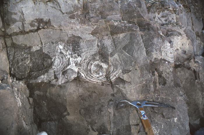
Fig. 2-72: Concentric siliceous concretions typically occur in limestones of the Cadellfjellet Member (here at Malte Brunfjellet, northern Sabine Land), but also in other members of the Wordiekammen Formation. Photo: W.K. Dallmann The top of the Cadellfjellet Member is defined by the base of the fusulinid limestones of the Brucebyen Beds. The Cadellfjellet Member was mostly deposited in open to semi-restricted shallow subtidal and restricted, intertidal or supratidal environments (Sundsbø 1982, unpubl.; Dons 1983, unpubl.; Pickard et al. 1996). Pyefjellet beds (CP-51) STATUS OF UNIT: Informal FIRST USE OF NAME: Pickard et al. 1996 CURRENT DEFINITION: Pickard et al. 1996 SYNONYM(S) AND REFERENCE(S): None ORIGIN OF NAME: Pyefjellet: A mountain in central Bünsow Land, central Spitsbergen TYPE SECTION (Fig. 2-73): Stratotype: Pyefjellet North, Bünsow Land DEPOSITIONAL AGE: Late Moscovian - Early Kasimovian DATING METHOD: Fusulinids REFERENCE(S) FOR AGE: I. Nilsson in Pickard et al. 1996 OVERLYING UNIT(S): Black Crag Beds UNDERLYING UNIT(S): Minkinfjellet Formation (Terrierfjellet member) SUPERIOR UNIT: Cadellfjellet Member OTHER USE OF NAME: None THICKNESS: Up to ca. 45 m, 36 m in stratotype MAIN LITHOLOGIES: Limestone LOWER BOUNDARY DEFINITION: The base of the Pyefjellet beds defines the base of the Cadellfjellet Member (see there) in parts of Bünsow Land. DESCRIPTION: The Pyefjellet beds consist of stacked marine limestone units with phylloid algal build-ups. The base of the stacked units consists of bedded, bioclastic wackestones which are normally overlain by massive phylloid algal and/or palaeoaplysina wackestones. The latter form distinct rock units which possessed a topographical relief on the sea-floor (carbonate build-ups). Thin packstone or grainstone beds are commonly developed near the top of the units and may form interbeds in the build-up facies. Each unit is capped by a subaerial exposure surface. Six units (ranging from ca. 3 m to 15 m in thickness) have been identified and correlated across central and eastern Bünsow Land. 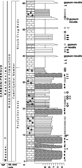
Fig. 2-73: Stratigraphic section CP-51/52. Stratotype for: Pyefjellet beds, Black Crag Beds. Locality: Pyefjellet N. Reference: Pickard et al. 1996 The Pyefjellet beds grade transitionally westwards into the predominantly evaporite-dolomite cycles of the uppermost part of the Minkinfjellet Formation. The beds are interpreted to have been deposited on an open marine platform. Black Crag Beds (CP-52) STATUS OF UNIT: Formal. Although "Black Crag" is a typical informal unit name, a formal status should be applied to the unit because of its prominence and widespread use in the geological literature. FIRST USE OF NAME: Cutbill & Challinor 1965 CURRENT DEFINITION: Cutbill & Challinor 1965 SYNONYM(S) AND REFERENCE(S): None ORIGIN OF NAME: Black Crag: A descriptive name of the dark weathering cliff made up of this unit along the mountain sides in central Bünsow Land, central Spitsbergen TYPE SECTION (Fig. 2-73): Stratotype: Pyefjellet North, Bünsow Land The stratotype was originally defined at western ridge of Cadellfjellet (Cutbill & Challinor 1965), but no documentation is available. DEPOSITIONAL AGE: Early Kasimovian - earliest Gzhelian DATING METHOD: Fusulinids REFERENCE(S) FOR AGE: I. Nilsson in Pickard et al. 1996 OVERLYING UNIT(S): Gerritbreen beds UNDERLYING UNIT(S): Pyefjellet beds, Minkinfjellet Formation SUPERIOR UNIT: Cadellfjellet Member OTHER USE OF NAME: None THICKNESS: Up to ca. 60 m, 25 m in stratotype MAIN LITHOLOGIES: Limestone LOWER BOUNDARY DEFINITION: The Black Crag Beds form the lowermost part of the Cadellfjellet Member in western Bünsow Land, but seem to overlie the Pyefjellet Beds farther east. The lower boundary is defined by the bottom of a prominent, dark weathering, cliff-forming limestone interval. The cliff is easily seen along the mountain sides and forms a distinct marker unit. DESCRIPTION: The Black Crag Beds form a series of mainly massive or thickly bedded, black to dark grey lime mudstones. They are commonly sparsely fossiliferous or totally barren, although the lower parts of the individual beds may contain abundant fusulinids. Subaerial exposure surfaces marked by minor karst development and locally by in situ Microcodium development are present in the tops of beds (Pickard et al. 1996). The thickness is >60 m in western Bünsow Land, but the unit thins towards the east. The Black Crag Beds are probably diachronous and young eastwards across Bünsow Land. The beds represent stacked subtidal, open marine to restricted hypersaline depositional settings (Pickard et al. 1996). Gerritbreen beds (CP-53) STATUS OF UNIT: Informal. The transition from the Gerritbreen to the overlying Mathewbreen beds is commonly poorly exposed and difficult to localise in the field. The status of the two units is therefore informal. FIRST USE OF NAME: Cutbill & Challinor 1965 CURRENT DEFINITION: Cutbill & Challinor 1965 SYNONYM(S) AND REFERENCE(S): None ORIGIN OF NAME: Gerritbreen: A glacier at Cadellfjellet in Bünsow Land, east of Billefjorden TYPE LOCALITY: Cadellfjellet, Bünsow Land DEPOSITIONAL AGE: Early Gzhelian DATING METHOD: Fusulinids REFERENCE(S) FOR AGE: I. Nilsson in Pickard et al. 1996 OVERLYING UNIT(S): Mathewbreen beds UNDERLYING UNIT(S): Black Crag Beds SUPERIOR UNIT: Cadellfjellet Member OTHER USE OF NAME: None THICKNESS: 70-180 m MAIN LITHOLOGIES: Limestone LOWER BOUNDARY DEFINITION: The base of the Gerritbreen Beds is defined by the top of the prominent, dark weathering, cliff-forming limestone interval of the Black Crag Beds. DESCRIPTION: The Gerritbreen beds display various carbonate lithologies including carbonate mudstones to packstones, and locally relatively thick (ca. 5 m) cross-bedded grainstone units. Grainstones dominate in coeval sediments on the Nordfjorden High (part of Kapitol Member) whereas mud-dominated textures are most common in the Gerritbreen beds of the Billefjorden Trough (Sundsbø 1982, unpubl.). The sabkha environments in the southeastern part of Bünsow Land grade into more open marine lagoonal settings towards the northeast. On the Nordfjorden High open marine, shallow, subtidal and high energy shoals acted as barriers to the more low-energy depositional settings to the east (Sundsbø 1982, unpubl.). Mathewbreen beds (CP-54) STATUS OF UNIT: Informal. The transition from the Gerritbreen to the overlying Mathewbreen beds is commonly poorly exposed and difficult to localise in the field. The status of the two units is therefore informal. FIRST USE OF NAME: Cutbill & Challinor 1965 CURRENT DEFINITION: Cutbill & Challinor 1965 SYNONYM(S) AND REFERENCE(S): None ORIGIN OF NAME: Mathewbreen: A glacier at Cadellfjellet in Bünsow Land, east of Billefjorden TYPE LOCALITY: Cadellfjellet, Bünsow Land DEPOSITIONAL AGE: Middle Gzhelian DATING METHOD: Fusulinids REFERENCE(S) FOR AGE: I. Nilsson in Pickard et al. 1996 OVERLYING UNIT(S): Tyrrellfjellet Member, Brucebyen Beds UNDERLYING UNIT(S): Gerritbreen beds SUPERIOR UNIT: Cadellfjellet Member OTHER USE OF NAME: None THICKNESS: 30-70 m MAIN LITHOLOGIES: Dolomite LOWER BOUNDARY DEFINITION: The base of the Mathewbreen beds is defined at a change in lithology from the limestone- dominated Gerritbreen beds to the dolomite-dominated Mathewbreen beds (Cutbill & Challinor 1965; Sundsbø 1982, unpubl.). Due to the lack of a better boundary definition, the Gerritbreen and Mathewbreen members are not considered to be formal units. DESCRIPTION: The Mathewbreen beds form a very poorly exposed succession of dolomites (often with gypsum moulds) and thin intercalated gypsum beds. Thin carbonate mudstone and packstone beds are also present (Sundsbø 1982, unpubl.). The unit is 30-45 m thick in Bünsow Land. The depositional environments were restricted, periodically hypersaline, shallow subtidal to peritidal settings (Sundsbø 1982, unpubl.). Tyrrellfjellet Member (CP-55) STATUS OF UNIT: Formal FIRST USE OF NAME: Cutbill & Challinor 1965 CURRENT DEFINITION: Cutbill & Challinor 1965; base redefined here SYNONYM(S) AND REFERENCE(S): None ORIGIN OF NAME: Tyrrellfjellet: A mountain east of Billefjorden, central Spitsbergen TYPE SECTION (Fig. 2-74): Stratotype: Urmstonfjellet, Bünsow Land. The stratotype was originally defined at the northern slope of Tyrrellfjellet (Cutbill & Challinor 1965), but no documentation is available. DEPOSITIONAL AGE: Late Gzhelian - Sakmarian DATING METHOD: Fusulinids REFERENCE(S) FOR AGE: Nilsson 1993 (unpubl.) OVERLYING UNIT(S): Gipshuken Formation UNDERLYING UNIT(S): Cadellfjellet, Kapitol and Mørebreen members SUPERIOR UNIT: Wordiekammen Formation OTHER USE OF NAME: None THICKNESS: 110-180 m, 121 m in stratotype MAIN LITHOLOGIES: Dolomite, limestone LOWER BOUNDARY DEFINITION: The base is here redefined to coincide with the base of the Brucebyen Beds, a prominent, dark fusulinid wackestone (see there). The original definition (Cutbill & Challinor 1965) is insufficiently clear. 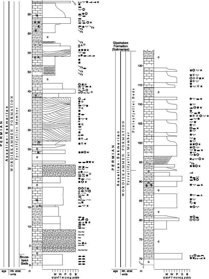
Fig. 2-74: Stratigraphic section CP-55. Stratotype for: Tyrrellfjellet Member. Locality: Urmstonfjellet. Reference: Lønøy, A. (unpubl.) DESCRIPTION: The Tyrrellfjellet Member forms the upper part of the Wordiekammen Formation across Spitsbergen and shows a more uniform facies than the underlying members. The Tyrrellfjellet Member consists of alternating limestones (mudstones through grainstones) and dolomites. Palaeoaplysinid build-ups are developed in the lower part of the member. Cross-bedded, quartz-rich lime-grainstones and one bed of calcitic quartz sandstone are locally present in the middle part of the member (Bünsow Land). The top of the sandstone bed defines the base of the Finlayfjellet Beds. Gypsum nodules as well as in-situ and transported Microcodium are scattered throughout the lower and middle parts of the member. Stacked cycles of packstones, grading up into mudstones, comprise the upper part of the member (Finlayfjellet Beds). The Tyrrellfjellet Member was deposited in marine environments ranging from shallow subtidal to inter-/subtidal (Lønøy 1981, unpubl.; Dons 1983, unpubl.; Johansen 1994, unpubl.). Palaeoaplysinid build-ups and associated interbuild-up lagoons developed in the early stages of deposition and were followed by bioclastic (and rarely oolitic) shoals prograding across an open to semi-restricted lagoon. During periodic falls of relative sea level the shoals may have been subaerially exposed, producing restricted, locally hypersaline, conditions in the lagoons (Lønøy 1981, unpubl.). Brucebyen Beds (CP-56) STATUS OF UNIT: Formal FIRST USE OF NAME: Cutbill & Challinor 1965 CURRENT DEFINITION: Cutbill & Challinor 1965 SYNONYM(S) AND REFERENCE(S): None ORIGIN OF NAME: Brucebyen: An abandoned coal prospecting settlement east of Billefjorden, central Spitsbergen TYPE SECTION (Fig. 2-75): Stratotype: Tyrrellfjellet, Bünsow Land DEPOSITIONAL AGE: Latest Gzhelian - Early Asselian DATING METHOD: Fusulinids REFERENCE(S) FOR AGE: Nilsson 1993 (unpubl.) OVERLYING UNIT(S): Not named UNDERLYING UNIT(S): Cadellfjellet and Kapitol members SUPERIOR UNIT: Tyrrellfjellet Member OTHER USE OF NAME: None THICKNESS: 8-11 m, 11 m in stratotype MAIN LITHOLOGIES: Limestone LOWER BOUNDARY DEFINITION: The base is marked by the first occurrence of dark fusulinid lime wackestones above the dolomites of the Cadellfjellet Member. 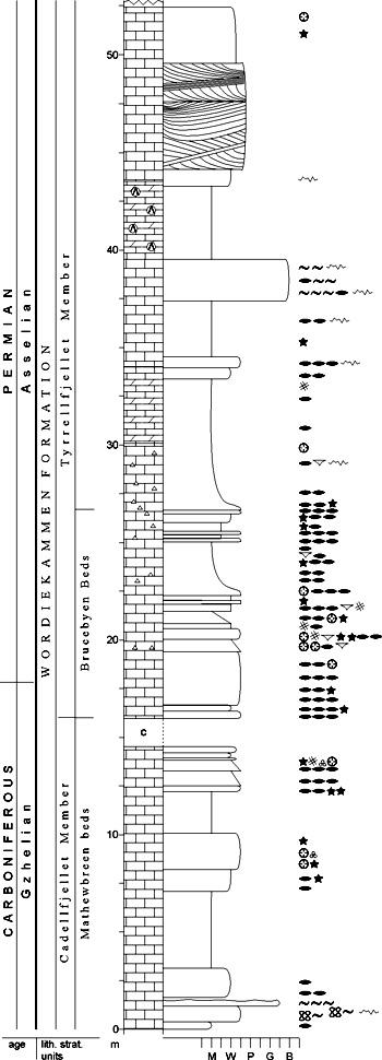
Fig. 2-75: Stratigraphic section CP-56. Stratotype for: Brucebyen Beds. Locality: Tyrrellfjellet N. Reference: Nilsson 1993 (unpubl.) DESCRIPTION: The Brucebyen Beds are dark grey fusulinid wackestones to packstones. They have both a gradational base and top. The base defines the lower boundary of the Tyrrellfjellet Member. The unit occurs from Orustdalen to Ny Friesland, but is not found in St. Jonsfjorden (Cutbill & Challinor 1965). The total organic content ranges from about 1% to more than 15% and is mainly derived from terrestrial vegetation (unpublished data, Norsk Hydro; Dons 1983, unpubl.). Deposition is believed to have occurred during a marine transgression (Sundsbø 1982, unpubl.). Finlayfjellet Beds (CP-57) STATUS OF UNIT: Formal FIRST USE OF NAME: Here CURRENT DEFINITION: Lønøy 1981 (unpubl.); Dons 1983 (unpubl.) SYNONYM(S) AND REFERENCE(S): "Limestone B": Gee et al. 1952. The name is changed here because of its inconvenient, informal character. ORIGIN OF NAME: Finlayfjellet: A mountain in Bünsow Land, central Spitsbergen TYPE SECTION (Fig. 2-76): Stratotype: Finlayfjellet SW, Bünsow Land DEPOSITIONAL AGE: ?Sakmarian DATING METHOD: Indirect, stratigraphic relationships REFERENCE(S) FOR AGE: Nilsson 1993 (unpubl.) OVERLYING UNIT(S): Gipshuken Formation UNDERLYING UNIT(S): Not named SUPERIOR UNIT: Tyrrellfjellet Member OTHER USE OF NAME: None THICKNESS: 30-50 m, 30 m in stratotype MAIN LITHOLOGIES: Limestone, dolomite LOWER BOUNDARY DEFINITION: The base of the Finlayfjellet Beds is defined by the onset of the thick, prominent carbonate unit described below, in central Spitsbergen overlying a calcite-cemented, very fine-grained sandstone bed. 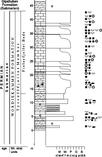
Fig. 2-76: Stratigraphic section CP-57. Stratotype for: Finlayfjellet Beds. Locality: Finlayfjellet SW. Reference: Lønøy, A. (unpubl.) DESCRIPTION: The Finlayfjellet Beds form a prominent, cliff-forming carbonate unit at the top of the Tyrrellfjellet Member in central Spitsbergen. They have a composite thickness of several tens of metres and are made up of stacked units of bioclastic packstones grading upwards into unfossiliferous to sparsely fossiliferous mudstones. Each unit is from a few tens of cm to 6 m thick. Packstones have an open marine fauna of mainly echinoderm fragments, brachiopods, coral fragments, bryozoans and fusulinids. The lowermost and especially the upper part of the succession are dolomitised. The transition to the overlying Gipshuken Formation is not exposed. The Finlayfjellet Beds have been interpreted as bioclastic banks migrating across a lagoonal environment (Dons 1983, unpubl.) The lagoon may have been periodically enclosed causing alternating open marine and semi-restricted conditions (Lønøy 1981, unpubl.). Kiærfjellet Beds (CP-58) STATUS OF UNIT: Formal FIRST USE OF NAME: Cutbill & Challinor 1965 CURRENT DEFINITION: Cutbill & Challinor 1965 SYNONYM(S) AND REFERENCE(S): None ORIGIN OF NAME: Kiærfjellet: A mountain on Brøggerhalvøya, Oscar II Land TYPE SECTION (Fig. 2-70): Stratotype: Traudalen, Brøggerhalvøya. The stratotype was originally defined at the northwestern slope of Scheteligfjellet (Cutbill & Challinor 1965), but no documentation is available. The two localities are situated close to each other. DEPOSITIONAL AGE: ?Sakmarian DATING METHOD: Indirect, stratigraphic relationships REFERENCE(S) FOR AGE: Nilsson 1993 (unpubl.) OVERLYING UNIT(S): Gipshuken Formation UNDERLYING UNIT(S): Not named SUPERIOR UNIT: Tyrrellfjellet Member OTHER USE OF NAME: None THICKNESS: 100 m in stratotype MAIN LITHOLOGIES: Dolomite LOWER BOUNDARY DEFINITION: The lower boundary corresponds to the base of the soft dolomite succession in the upper part of the Tyrrellfjellet Member. DESCRIPTION: The Kiærfjellet beds form the upper part of the Tyrrellfjellet Member from Brøggerhalvøya to Orustdalen (except for St. Jonsfjorden) and are probably mappable to Ekmanfjorden ("Lower Dolomite members" of Bates & Schwarzacher, 1958) and to Bünsow Land (Finlayfjellet Beds). They consist of thinly bedded, soft dolomite. They form a marker horizon above resistant limestones with fusulinids. Their lateral relationship with the Finlayfjellet Beds has not been described. Idunfjellet Member (CP-59) STATUS OF UNIT: Formal FIRST USE OF NAME: Lauritzen 1981 CURRENT DEFINITION: Lauritzen 1981 SYNONYM(S) AND REFERENCE(S): None ORIGIN OF NAME: Idunfjellet (from the Old Nordic goddess "Idun"): A mountain at Wahlenbergfjorden, Nordaustlandet TYPE SECTION (Fig. 2-77): Stratotype: Idunfjellet, Nordaustlandet DEPOSITIONAL AGE: Moscovian (lower part of member) DATING METHOD: Foraminifera REFERENCE(S) FOR AGE: Lauritzen 1981 OVERLYING UNIT(S): Gipshuken Formation UNDERLYING UNIT(S): Hårbardbreen Formation SUPERIOR UNIT: Wordiekammen Formation OTHER USE OF NAME: None THICKNESS: 135 m in stratotype MAIN LITHOLOGIES: Dolomite LOWER BOUNDARY DEFINITION: The base of the member is defined by the introduction of carbonates above the clastic Hårbardbreen Formation. 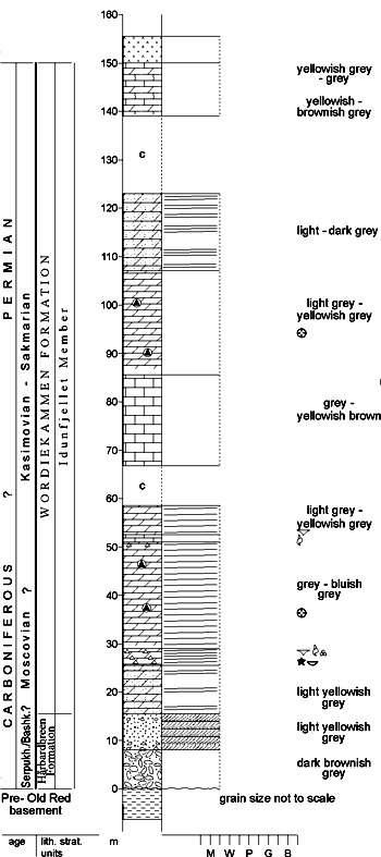
Fig. 2-77: Stratigraphic section CP-59/68a. Stratotype for: Idunfjellet Member. Boundary stratotype for: Hårbardbreen Formation. Locality: Idunfjellet. Reference: Lauritzen 1981 DESCRIPTION: The Idunfjellet Member constitutes the entire Wordiekammen Formation on Nordaustlandet. The lowermost part of the TYPE SECTION shows a 10 m thick sandy dolomite overlain by a 3.5 m thick, partly dolomitised and silicified biosparite which is resistant to weathering. Overlying this is a 78 m thick sequence of limestone and dolomite and a 16 m thick succession of sandy dolomite. The uppermost part of the member consists of dolomites with erosive surfaces, intraformational conglomerates and cross-bedded units. The top of the member is defined by the base of a dolomite breccia which is assigned to the Gipshuken Formation. The unit was deposited in shallow marine to open shelf environments, with input of quartz in the lower and upper parts. The upper part shows shallowing of the sea with possible tidal influence (Lauritzen 1981). Back to top GIPSHUKEN FORMATION (CP-60) 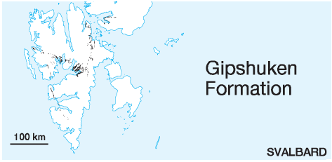 DISTRIBUTION shown on Fig. 2-06, Fig. 2-07, Fig. 2-08, Fig. 2-09, Fig. 2-10
STATUS OF UNIT: Formal FIRST USE OF NAME: Cutbill & Challinor 1965 CURRENT DEFINITION: Cutbill & Challinor 1965 SYNONYM(S) AND REFERENCE(S): "Gypsum beds": Nathorst 1910 ORIGIN OF NAME: Gipshuken (transl. "Gypsum Point"): A cape at Sassenfjorden TYPE SECTION (Fig. 2-80, Fig. 2-81): Stratotype: Bredsdorffberget, Dickson Land Hypostratotype: Skansdalen, Dickson Land. The stratotype was originally defined at the southwestern ridge of Cowantoppen, close to Gipshuken (Cutbill & Challinor 1965), but no documentation is available. STRUCTURAL SETTING: Late Palaeozoic platform of Svalbard/Barents Sea Shelf DEPOSITIONAL AGE: Sakmarian - Artinskian DATING METHOD: Brachiopods, bryozoans, conodonts, foraminifers and palynomorphs REFERENCE(S) FOR AGE: Nakrem et al. 1992; Nakrem 1993; Mangerud & Konieczny 1991; Sosipatrova 1967 OVERLYING UNIT(S): Kapp Starostin Formation UNDERLYING UNIT(S): Wordiekammen Formation, Treskelodden Formation SUPERIOR UNIT: Dickson Land Subgroup OTHER USE OF NAME: None THICKNESS: Up to ca. 280 m, ca. 245 m in stratotype MAIN LITHOLOGIES: Dolomite, limestone, anhydrite/gypsum, carbonate breccias LOWER BOUNDARY DEFINITION: The formational base is defined where anhydrite, besides dolomite, becomes dominant in the section, or at the first occurrence of a massive carbonate breccia which regionally replaces the anhydrite-rich facies. DESCRIPTION: The Gipshuken Formation (Fig. 2-78, Fig. 2-79) is exposed across large parts of Svalbard and is thought to have been deposited over the entire archipelago, except for the southernmost part of Spitsbergen, where it seems to interfinger with the clastic sediments of the Treskelen Subgroup against the margins of the Sørkapp-Hornsund High. 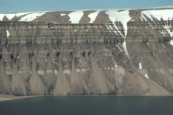
Fig. 2-78: The carbonate rocks of the Gipshuken Formation (Templet and Skansdalen members) form steep cliffs on central Spitsbergen, here at Sindballefjellet, Tempelfjorden. They form the middle third of the cliff, while the lower third is made up of the gypsum/anhydrite-dominated Vengeberget member. The succession is capped by the cherts and siliceous limestones of the Kapp Starostin Formation. Photo: W.K. Dallmann The formation represents platform deposits of interbedded anhydrite/gypsum and dolomite/limestone units with thin marl beds and possibly two types of carbonate breccia. An erosional surface on top of a caliche succession marks the top of the Gipshuken Formation. It represents the end of a period of cyclic sabkha deposition with intermediate marine transgressions over a large platform area. A 2-5 cm thick, shaley, dark brown to black bed usually defines the marine transgression represented by the Vøringen Member of the overlying Kapp Starostin Formation. 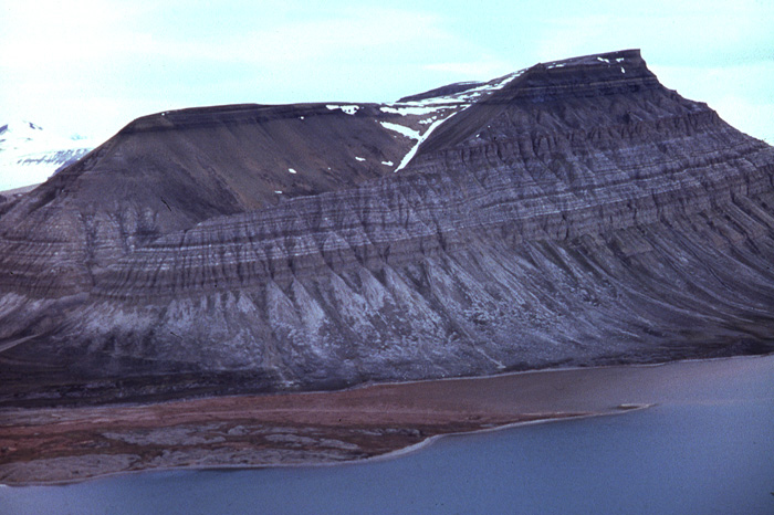
Fig. 2-79: Carboniferous-Permian stratigraphy at the mountain Kolosseum (Ekmanfjorden, James I Land): Above the carbonate rocks of the Wordiekammen Formation, white gypsum/anhydrite layers indicate the Vengeberget member of the Gipshuken Formation, upwards succeeded by the carbonates of the Skansdalen member. The succession is capped by the cherts and siliceous limestones of the Kapp Starostin Formation. Photo: H.B. Keilen The Gipshuken Formation is subdivided into the Vengeberget, Zeipelodden, Kloten, Skansdalen, Templet and Sørfonna members (both vertically and laterally arranged). In general, the subdivision underlines the prominent vertical twofold subdivision of the Gipshuken Formation. Collectively, they comprise most of the formation in central and northern areas, and in western Spitsbergen north of St. Jonsfjorden. In western Spitsbergen south of Isfjorden, the formation is not described well enough to apply member names. "Cancrinella limestone" (Birkenmajer & Logan 1969) has informally been used for a local facies at Kopernikusfjellet (Wedel Jarlsberg Land). All members are suggested to have informal status until their use has been established in the geological literature and proven to be appropriate. 
Fig. 2-80: Stratigraphic section CP-60a. Stratotype for: Gipshuken Formation. Locality: Bredsdorffberget. Reference: Keilen, H.B. (unpubl.) Vengeberget member (CP-61) STATUS OF UNIT: Informal FIRST USE OF NAME: Here CURRENT DEFINITION: Here SYNONYM(S) AND REFERENCE(S): None ORIGIN OF NAME: Vengeberget: A mountain in James I Land, between Dicksonfjorden and Ekmanfjorden TYPE SECTION (Fig. 2-83): Stratotype: Vengeberget, James I Land DEPOSITIONAL AGE: Sakmarian - ?Artinskian DATING METHOD: See Gipshuken Formation REFERENCE(S) FOR AGE: See Gipshuken Formation OVERLYING UNIT(S): Skansdalen member UNDERLYING UNIT(S): Tyrrellfjellet Member (Wordiekammen Formation) SUPERIOR UNIT: Gipsdalen Formation OTHER USE OF NAME: None THICKNESS: 100-120 m, 109 m in stratotype MAIN LITHOLOGIES: Anhydrite/gypsum, dolomite, marl LOWER BOUNDARY DEFINITION: The base of the member is defined by the first occurrence of massive anhydrite beds on top of the dolomite/marl dominated Tyrrellfjellet Member. 
Fig. 2-81: Stratigraphic section CP-60b/64. Hypostratotype for: Gipshuken Formation. Stratotype for: Skansdalen member. Locality: Skansdalen. Reference: Keilen, H.B. (unpubl.) DESCRIPTION: The Vengeberget member is the lower, gypsum/anhydrite-dominated part of the Gipshuken Formation. It occurs within a NNW-SSE trending, ca. 30 km wide zone from east of Kongsfjorden through Ekmanfjorden to eastern Nordenskiöld Land. It shows relatively abrupt lateral transitions with the Kloten breccia member to the southwest, and with the Zeipelodden breccia member to the north-east. Rhythmites of anhydrite/gypsum, dolomite and marl dominate the member (approximately 90-110 m) in the western part of James I Land (Palatiumfjella, Fig. 2-82) to Rejmyrefjellet east of Tempelfjorden. The dominant white to light grey colour of this unit is characteristic in central Spitsbergen. The dolomites are dominated by finely laminated algal mats. Occasional small gastropods and bivalves are seen. Polygonal cracks, tepee structures and stylolites occur frequently. Oolitic limestone beds occur occasionally (5-50 cm thick). Various fabrics of anhydrite are seen, for instance anhydrite nodules, enterolithic layers and chickenwire textures. The anhydrite and dolomite beds vary from 2 cm to 5.5 m thick. Marly units are up to 50 cm thick, although most commonly only 3-5 cm. Between 30-40 rhythmically repeated units of anhydrite/dolomite/marl are seen through the unit. Internal deformation structures are seen in anhydrites throughout the unit. 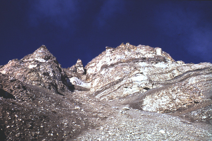
Fig. 2-82: Gypsum layers of the Vengeberget member at Palatiumfjellet (James I Land). Photo: H.B. Keilen The top of the Vengeberget member is marked by the disappearance of anhydrite and dolomite, limestone and marl become the dominant lithologies. 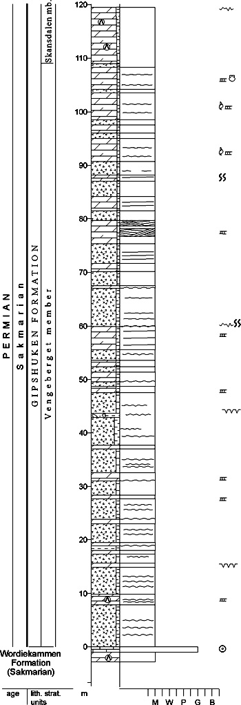
Fig. 2-83: Stratigraphic section CP-61. Stratotype for: Vengeberget member. Locality: Vengeberget. Reference: Keilen, H.B. (unpubl.), modified from Lauritzen 1981 The facies of the Vengeberget member reflects a sabkha environment and consists of stacked sabkha units of anhydrite, dolomite and marl, deposited in a shallow marine, occasionally restricted langoonal to supratidal environment with very slow subsidence. The climate is interpreted to have been semi-arid (Steel & Worsley 1984). Rhythms may be caused by occasional storms or relatively small sea-level changes. Oolites are interpreted to be nearshore bars or tidal channel infillings. Flora and fauna show very little diversity, but individual populations are large when seen, a feature typical for a hypersaline environment. Zeipelodden member (CP-62) STATUS OF UNIT: Informal FIRST USE OF NAME: Lauritzen 1981 CURRENT DEFINITION: Lauritzen 1981 SYNONYM(S) AND REFERENCE(S): None ORIGIN OF NAME: Zeipelodden: The cape between Palanderbukta and Wahlenbergfjorden on Nordaustlandet TYPE SECTION (Fig. 2-84): Stratotype: Zeipelodden, Nordaustlandet DEPOSITIONAL AGE: Sakmarian - ?Artinskian DATING METHOD: See Gipshuken Formation REFERENCE(S) FOR AGE: See Gipshuken Formation OVERLYING UNIT(S): Sørfonna and Skansdalen members UNDERLYING UNIT(S): Idunfjellet Member (Wordiekammen Formation) SUPERIOR UNIT: Gipsdalen Formation OTHER USE OF NAME: None THICKNESS: 40-50 m, 8 m in stratotype MAIN LITHOLOGIES: Carbonate breccia, limestone LOWER BOUNDARY DEFINITION: The base of the member is defined at the stratigraphic onset of limestone breccias above the dolomites of the Idunfjellet Member. 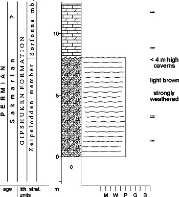
Fig. 2-84: Stratigraphic section CP-62. Stratotype for: Zeipelodden member. Locality: Zeipelodden. Reference: Keilen, H.B. (unpubl.), modified from Lauritzen 1981 DESCRIPTION: The Zeipelodden member occurs on eastern Svalbard and passes laterally into the evaporitic Vengeberget member of central Spitsbergen. It consists of alternating, unstructured carbonate breccias and algal-laminated limestones. The original dolomite breccias are widely dedolomitised. Irregularly bedded horizons are weathered into up to 5 m high caverns, a property which makes them visible from a distance. The sediments are highly porous. The member occurs north of a line striking NW-SE from Torfjellet, west of Pyramiden (Dickson Land) to Sindballefjellet (Bünsow Land) and Rejmyrefjellet (Sabine Land). The thickness of this unit varies considerably, but it is reported to be approximately 40-70 m at Mjølnerfjellet (east of Lomfjorden), at Sindballefjellet and at Tyrrellfjellet (Bünsow Land). Irregular breccia fragments of different sizes (1-30 cm) and shape, with a chaotic appearance, are seen, and a secondary porosity is well developed. The weathered surface is light brown with a brecciated appearance and well-developed cavities. On Nordaustlandet (localities of Idunfjellet and Zeipelfjella) the unit is subdivided into two separate breccias with intervening laminated dolomite and marls. The Zeipelodden member is interpreted as a solution breccia. During deposition of the sabkha sediments of the Vengeberget member, eastern areas formed a hinterland exposed to weathering and karstification and hence solution of earlier deposited anhydrite. This unit may represent a lateral time equivalent of upper parts of the Tyrrellfjellet Member. Collapse of dolomite beds and an extensive karstification occurred due to semiarid climate (Steel and Worsley 1984) and dissolution of the anhydrite. On Nordaustlandet, a local transgression, producing a supratidal to intertidal lagoonal environment, split up this member into two distinct (lower and upper) units. Kloten member (CP-63) STATUS OF UNIT: Informal FIRST USE OF NAME: Cutbill & Challinor 1965 CURRENT DEFINITION: Cutbill & Challinor 1965 SYNONYM(S) AND REFERENCE(S): None ORIGIN OF NAME: Kloten (transl. "The Heap"): A mountain on Brøggerhalvøya, Oscar II Land TYPE LOCALITY: Scheteligfjellet NE, Brøggerhalvøya DEPOSITIONAL AGE: Sakmarian - ?Artinskian DATING METHOD: Indirect, stratigraphic relationships. See Gipshuken Formation REFERENCE(S) FOR AGE: See Gipshuken Formation OVERLYING UNIT(S): ?Skansdalen members UNDERLYING UNIT(S): Tyrrellfjellet Member (Wordiekammen Formation) SUPERIOR UNIT: Gipsdalen Formation OTHER USE OF NAME: None THICKNESS: 88 m in stratotype MAIN LITHOLOGIES: Limestone and dolomite breccia LOWER BOUNDARY DEFINITION: Kloten breccia type sediments occur with upward increasing thickness and frequencey in the Gipshuken Formation of northwestern Spitsbergen. The base of the member is arbitrarily defined at the first occurrence of carbonate breccia units thicker than 2 m. DESCRIPTION: The Kloten breccia occurs on western Spitsbergen in Permian outcrops of the Cenozoic fold belt. It has been observed as far south as Bellsund. Breccias and conglomerates that occur in the Gipshuken Formation even farther south, are not correlated with certainty. The Kloten member probably interfingers with the Vengeberget member to the NE along the eastern margin of the St. Jonsfjorden Trough. Along the west coast of Spitsbergen, from Brøggerhalvøya to St. Jonsfjorden and possibly farther south – from Outer Isfjorden to Bellsund – dolomite dissolution breccias (in-place brecciation) occur together with the dolomite/marl beds seen elsewhere on Spitsbergen. Breccia fragments are sharp-edged and occur as rectangular, randomly mixed 2-15 cm long fragments of cracked and ruptured dolomite beds in a microcrystalline dolomite matrix. Only scattered occurrences of anhydrite in the lowermost part in the unit are reported from the southern parts of the exposure area. The Kloten member is interpreted as a tectonic dissolution breccia. Anhydrite is thought to have been primarily deposited in the area. It was dissolved and dolomite beds collapsed. There are no signs of karstification. Skansdalen member (CP-64) STATUS OF UNIT: Informal FIRST USE OF NAME: Here CURRENT DEFINITION: Here SYNONYM(S) AND REFERENCE(S): None ORIGIN OF NAME: Skansdalen: A valley in Dickson Land, named after Skansen, transl. "The Rampart", an adjacent mountain TYPE SECTION (Fig. 2-81): Stratotype: Skansdalen, Dickson Land DEPOSITIONAL AGE: Sakmarian - Artinskian DATING METHOD: See Gipshuken Formation REFERENCE(S) FOR AGE: See Gipshuken Formation OVERLYING UNIT(S): Vøringen Member (Kapp Starostin Formation) UNDERLYING UNIT(S): Vengeberget, Kloten and Zeipelodden members SUPERIOR UNIT: Gipsdalen Formation OTHER USE OF NAME: None THICKNESS: Up to 150 m, ca. 100 m in stratotype MAIN LITHOLOGIES: Dolomite, limestone, marl, anhydrite/gypsum and caliche LOWER BOUNDARY DEFINITION: The member base is defined at the base of massive dolomites above the evaporitedominated Vengeberget member or above the carbonate breccias of the Zeipelodden and Kloten members. DESCRIPTION: The Skansdalen member forms the upper part of the Gipshuken Formation in western areas of Spitsbergen, from Brøggerhalvøya in the NW to Torell Land in the SE, and in central Spitsbergen including Dickson Land. It interfingers laterally with the limestones of the Templet member in the east. The lateral transition to the Sørfonna member on Nordaustlandet has not yet been defined. The Skansdalen member consists of regularly bedded dolomites (5-15 cm thick) intercalated with 2-10 cm marly beds. Finely laminated dolomites dominate towards the top of the formation (150-180 m). Bioturbation is common. Caliche beds, erosional surfaces and oolite beds (10-50 cm thick) occur more frequently towards the top. A 10-20 m thick unit of anhydrite/dolomite/marl occurs throughout central Spitsbergen 10-15 m below the top. The member is interpreted as a supra- to intertidal sediment. Finely laminated dolomite beds with root structures and desiccation cracks are interpreted as shallow marine/lagoonal algal mats. Periodic minor sea-level fluctuations are suggested. Erosional surfaces, oolite bars and caliche are recognised, as well as open marine faunas (brachiopods, crinoids, bryozoans, corals). A short regressive period with renewed sabkha environments is interpreted at 10-15 m below the upper formation boundary. Templet member (CP-65) STATUS OF UNIT: Informal FIRST USE OF NAME: Here CURRENT DEFINITION: Here SYNONYM(S) AND REFERENCE(S): None ORIGIN OF NAME: Templet (transl. "The Temple"): A mountain in Bünsow Land TYPE SECTION (Fig. 2-85): Stratotype: Templet NW, Bünsow Land DEPOSITIONAL AGE: Sakmarian - Artinskian DATING METHOD: See Gipshuken Formation REFERENCE(S) FOR AGE: See Gipshuken Formation OVERLYING UNIT(S): Skansdalen member UNDERLYING UNIT(S): Skansdalen member SUPERIOR UNIT: Gipsdalen Formation OTHER USE OF NAME: None THICKNESS: 100-135 m, ca. 135 m in stratotype MAIN LITHOLOGIES: Limestone LOWER BOUNDARY DEFINITION: The base of the member is defined where limestones start to dominate the succession above dolomites of the Skansdalen member. Although all beds are conformable, the onset of dominant lime content in the carbonate rocks is laterally moving up-section. 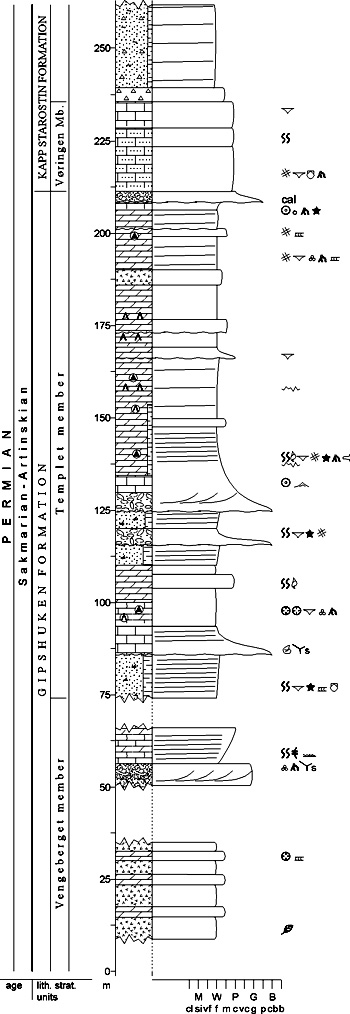
Fig. 2-85: Stratigraphic section CP-65. Stratotype for: Templet member. Locality: Templet NW. Reference: Keilen, H.B. (unpubl.) DESCRIPTION: The Templet member represents a local limestone facies in the upper part of the Gipshuken Formation. It forms a wedge within and interfingers with the dolomitedominated Skansdalen member. Both faunal and floral diversity are high. Large bivalves (up to 5 cm long), brachiopods, gastropods, crinoids, bryozoans, rugose corals, algal mats and small foraminifera are common. Bioturbation is commonly seen (Rhizocorallium, Thalassinoides, Zoophycos). Crossbedded carbonate sands (size order 1 m) are seen at several levels. Chert nodules are common, generally spacially related to the occurrence of Thalassinoides. Scattered sponge spicules are observed in thin section and may form spiculite beds a few cm thick. Erosional surfaces are seen. Caliche occurs and forms 10-100 cm thick beds. Root structures and Microcodium are common. Oncolites have been observed in one bed in the uppermost part of the unit. Stylolites are present in dolomite beds throughout the unit. This unit is interpreted as representing a mixed open marine to sub/inter/supratidal environment. The fauna is very diverse in the marine facies. Oolite barriers separated the open marine from the restricted lagoonal environments. The latter are dominated by algal mats, gastropods and small bivalves. Supratidal sabkha environments occur at 10-15 m below the top of the formation boundary. Sørfonna member (CP-66) STATUS OF UNIT: Informal FIRST USE OF NAME: Here CURRENT DEFINITION: Here, following Lauritzen 1981 SYNONYM(S) AND REFERENCE(S): "Calciferous Sandstone Series": Holland 1961 ORIGIN OF NAME: Sørfonna (transl. "The Southern Ice Cap"): A large plateau glacier on Nordaustlandet TYPE SECTION (Fig. 2-86): Stratotype: Zeipelfjella E, Nordaustlandet DEPOSITIONAL AGE: Sakmarian - Artinskian DATING METHOD: See Gipshuken Formation REFERENCE(S) FOR AGE: See Gipshuken Formation OVERLYING UNIT(S): Vøringen Member (Kapp Starostin Formation) UNDERLYING UNIT(S): Zeipelodden member SUPERIOR UNIT: Gipsdalen Formation OTHER USE OF NAME: None THICKNESS: 60 – 66 m, 66 m in stratotype MAIN LITHOLOGIES: Limestone, dolomite, coal LOWER BOUNDARY DEFINITION: The base is defined where bedded or laminated biomicritic and biosparitic limestones overlie the breccias of the Zeipelodden member. 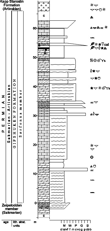
Fig. 2-86: Stratigraphic section CP-66. Stratotype for: Sørfonna member. Locality: Zeipelfjella E. Reference: Keilen, H.B. (unpubl.) DESCRIPTION: The Sørfonna member forms the upper part of the Gipshuken Formation on Nordaustlandet. The lateral transition to the Skansdalen and Templet members of central Spitsbergen is not preserved, but is thought to have occurred in Ny Friesland. Though a distinct boundary is seen between the Sørfonna member and the underlying breccias of the Zeipelodden member in the exposures on Nordaustlandet, the overall relation of the two members is interpreted as a diachronous interfingering. This unit is dominated by fine-grained algal laminated dolomites and limestones, abundant root structures and plant fragments, caliche beds and erosional surfaces. Sponge spicules occur, occasionally forming spiculites. Replacement of carbonate by chert is more frequent here than elsewhere in the Gipshuken Formation. Minor coal beds (up to 2 cm thick) occur frequently throughout the member. Brachiopods, ostracods, bryozoans and rugose corals are present. Algae are commonly found. Erosive surfaces separate several coarsening-upward sequences on a metre- to 10 m-scale. Caliche occurs in the upper parts of the member. On the southwestern slopes of Zeipelfjella, greyish to brownish, thickly bedded, mediumgrained dolomites with scattered chert nodules occur. No evaporites have been described from this unit. The much higher frequency of plant fragments, the onset of thin coal beds intercalated with finely laminated lagoonal algal dolomite, and more open marine conditions represented by limestones and an open marine fauna (corals, bryozoans, brachiopods) suggest increasing humidity subsequent to the previous arid conditions during the late Sakmarian/earliest Artinskian. Back to top MALTE BRUNFJELLET FORMATION (CP-67) 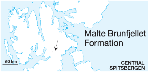 DISTRIBUTION shown on Fig. 2-10
STATUS OF UNIT: Formal FIRST USE OF NAME: Here, following Olaussen et al. (1986, unpubl.) CURRENT DEFINITION: Here SYNONYM(S) AND REFERENCE(S): None ORIGIN OF NAME: Malte Brunfjellet: A mountain in N Sabine Land TYPE SECTION (Fig. 2-88): Stratotype: Malte Brunfjellet, N Sabine Land STRUCTURAL SETTING: Ny Friesland High DEPOSITIONAL AGE: Early Moscovian (upper part of formation) DATING METHOD: Foraminifera REFERENCE(S) FOR AGE: I. Nilsson in Olaussen et al. 1986 (unpubl.) OVERLYING UNIT(S): Wordiekammen Formation UNDERLYING UNIT(S): Pre-Old Red LATERALLY ADJACENT UNIT(S): ?Minkinfjellet Formation, ?Hårbardbreen Formation SUPERIOR UNIT: Gipsdalen Group OTHER USE OF NAME: None THICKNESS: Up to 100 m, ca. 70 m in stratotype MAIN LITHOLOGIES: Sandstone, conglomerate, limestone LOWER BOUNDARY DEFINITION: The lower boundary is an angular unconformity above folded, but unmetamorphosed Vendian basement correlated with the Wilsonbreen Formation (interbedded red and green siltstone, very fine sandstone, mudstone and thin dolomite beds). DESCRIPTION: Above the basal unconformity, a 2-3 m thick transitional zone of red and green "mottled shale" occurs, probably representing a weathering zone or paleosol. Above this zone, the lower part (A) of the Malte Brunfjellet Formation shows 18 m thick interbedded sandstones, conglomerates, red shales and sandy red shales. These beds are interpreted as distal alluvial fan deposits, including stream channels, overbank levees, sheet floods and paleosols. The overlying part (B) is about 30 m thick, though mainly covered, but small outcrops show coarse sandstones, conglomerates and carbonate rocks. The upper part (C) is 20 m thick and comprises coarse sandstones and conglomerates interbedded with biogenic carbonates including stromatolites and intraformational conglomerates (Fig. 2-87). These beds are interpreted as fan delta deposits with fluvio-marine channels, subtidal channels, subtidal to intertidal bars, intertidal flats and beach spits. 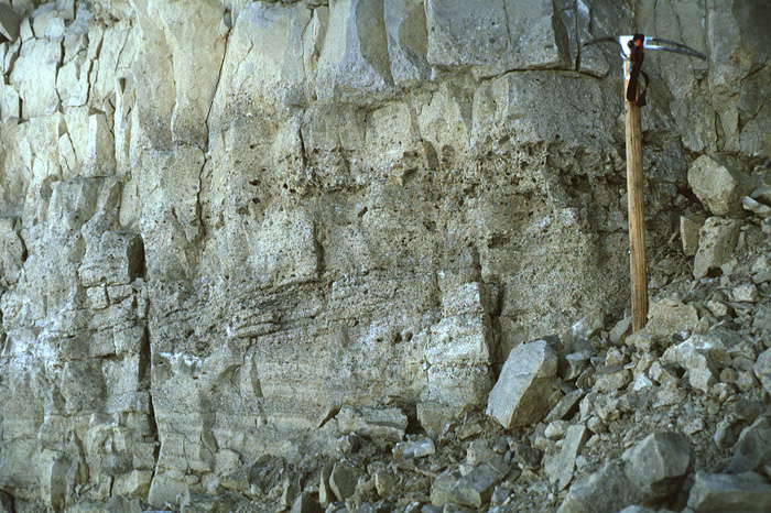
Fig. 2-87: Limestone gravel conglomerate intercalated with massive limestones, a typical rock association of the upper parts of the Malte Brunfjellet Formation, indicating the transition from clastic to carbonate deposition. Malte Brunfjellet (northern Sabine Land). Photo: W.K. Dallmann Different authors provided variable thickness measurements of the entire formation: Winsnes (1966): 92 m; Cutbill (1968): 97 m; Olaussen et al. (1986, unpubl.): 69 m. The upper boundary is transitional to the overlying, pure carbonates of the Wordiekammen Formation, indicating a continuous transgression. 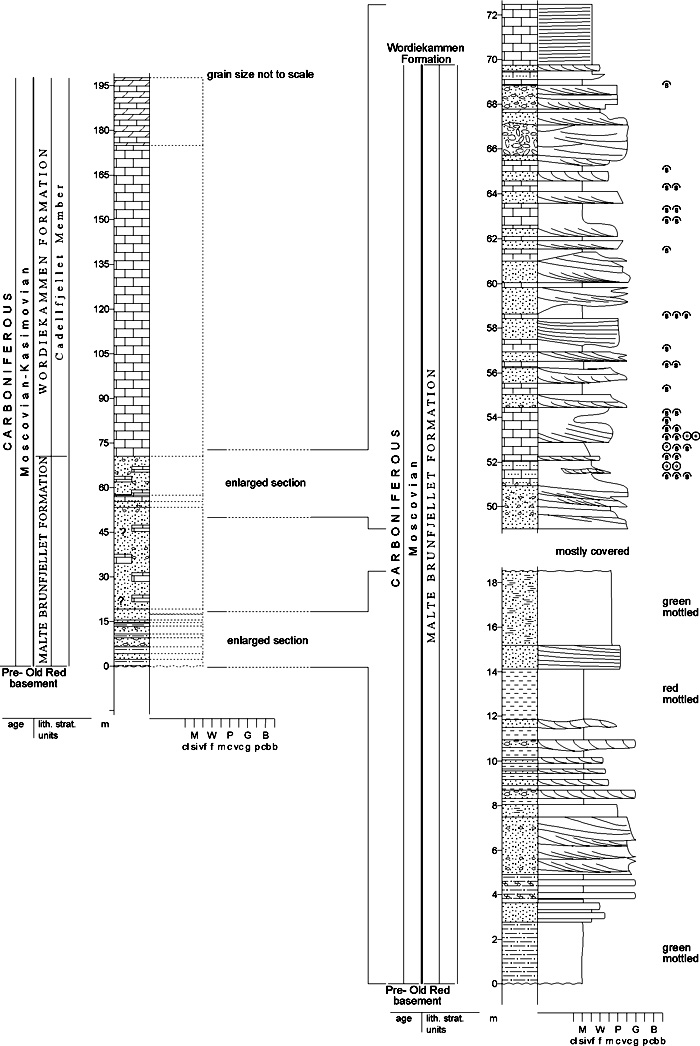
Fig. 2-88: Stratigraphic section CP-67. Stratotype for: Malte Brunfjellet Formation. Locality: Malte Brunfjellet. Reference: Olaussen et al. 1986 (unpubl.) The Malte Brunfjellet Formation has previously been regarded as a correlative of the Minkinfjellet Formation because of its probably similar age (Cutbill 1968), while Olaussen et al. (1986, unpubl.) noted its lithological similarities to the Ebbadalen and Hårbardbreen formations. The lithostratigraphic correlation with the Minkinfjellet Formation is abandoned. They are lithologically not similar, and the two formations occur far (20 km) from each other. A lateral transition has not been shown, although it may be expected. Similar rocks at a comparable stratigraphic level at Lomfjorden may be correlatives of the Malte Brunfjellet Formation, but documentation is lacking. Back to top HÅRBARDBREEN FORMATION (CP-68) 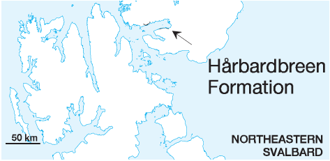 DISTRIBUTION shown on Fig. 2-10
STATUS OF UNIT: Formal FIRST USE OF NAME: Cutbill & Challinor 1965 CURRENT DEFINITION: The type section description of Lauritzen (1981) is supplemented by Olaussen et al. (1984b unpubl.). SYNONYM(S) AND REFERENCE(S): Hårbardbreen "Member": Cutbill & Challinor 1965 ORIGIN OF NAME: Hårbardbreen: A glacier near Wahlenbergfjorden, Nordaustlandet TYPE SECTION (Fig. 2-77, Fig. 2-89): Boundary stratotype: Idunfjellet, Nordaustlandet. Unit stratotype: Ismåsestranda, Nordaustlandet STRUCTURAL SETTING: ?Ny Friesland High DEPOSITIONAL AGE: Serpukhovian - Moscovian DATING METHOD: Indirect, stratigraphic relationships (very uncertain) REFERENCE(S) FOR AGE: Olaussen et al. 1984b (unpubl.) OVERLYING UNIT(S): Wordiekammen Formation UNDERLYING UNIT(S): Pre-Old Red SUPERIOR UNIT: Gipsdalen Group OTHER USE OF NAME: None THICKNESS: 15-?40 m MAIN LITHOLOGIES: Sandstone, conglomerate, shale LOWER BOUNDARY DEFINITION: The lower boundary is defined at the angular unconformity with the underlying Precambrian basement. 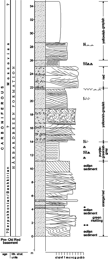
Fig. 2-89: Stratigraphic section CP-68b. Unit stratotype for: Hårbardbreen Formation. Locality: Ismåsestranda, Hårbardbreen. Reference: Olaussen et al. 1984b (unpubl.) DESCRIPTION: The base of the formation at Idunfjellet consists of an 8 m thick conglomerate containing mostly clasts of dolomitic mudstones, but clasts from underlying, redcoloured basement are also common. A 7.5 m thick light yellowish-grey sandstone overlies the conglomerate. The thickness varies from 15.5 m on Idunfjellet to ca. ?40 m at Ismåsestranda. The variation is caused by the local development, dependent upon topography of the underlying basement peneplain. The most completely developed and best investigated section at Ismåsestranda (type section) lacks the basal part (10-20 m) of the formation; the Idunfjellet section is therefore used as a boundary stratotype. At Hårbardbreen/Ismåsestranda, the formation is divided into two units. The lower unit comprises red sandstones interpreted as stream channels and overbank deposits separated by aeolian dune deposits. A muddy, mottled paleosol is also observed. The upper unit comprises yellowish/greyish sandstones interpreted as an estuarine channel complex and shoreface deposits. This coastal section is interrupted by a conglomeratic braided stream channel and a muddy paleosol. The upper boundary is transitional to sandy dolomites of the Idunfjellet Member (Wordiekammen Formation). Back to top LANDNØRDINGSVIKA FORMATION (CP-69)  DISTRIBUTION shown on Fig. 2-05
STATUS OF UNIT: Formal FIRST USE OF NAME: Krasil'ščikov & Livšic 1974 CURRENT DEFINITION: Worsley &Edwards 1976 SYNONYM(S) AND REFERENCE(S): "Red Conglomerate": Andersson 1900 ORIGIN OF NAME: Landnørdingsvika (transl. "The Bay of the 'Landnørding' [northeastern wind]"): A bay on SW Bjørnøya TYPE SECTION (Fig. 2-91, Fig. 2-92): Stratotype: Landnørdingsvika, Bjørnøya SW Hypostratotype: Kobbebukta, Bjørnøya N STRUCTURAL SETTING: West Bjørnøya Trough DEPOSITIONAL AGE: Bashkirian DATING METHOD: Fusulinids REFERENCE(S) FOR AGE: Worsley & Edwards 1976 (not documented); Simonsen 1988 (unpubl.) OVERLYING UNIT(S): Kapp Kåre Formation, locally Hambergfjellet Formation UNDERLYING UNIT(S): Nordkapp Formation SUPERIOR UNIT: Gipsdalen Group OTHER USE OF NAME: None THICKNESS: Up to 200 m MAIN LITHOLOGIES: Red mudstone, conglomerate, sandstone LOWER BOUNDARY DEFINITION: The base of the formation in the type section is placed at the appearance of thick, red mudstones (Worsley & Edwards 1976) above the coarsergrained clastics of the Nordkapp Formation. DESCRIPTION: The lower part of the formation consists of red mudstones, interstratified with relatively thin sandstone beds. The middle part consists of relatively thick, red to yellow conglomerates interbedded with red and green mudstones and grey and red sandstones of marine origin (Fig. 2-90). The upper part comprises calcareous sandstones in alternation with red and green mudstones and siltstones. 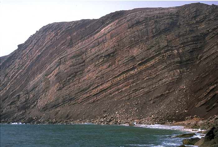
Fig. 2-90: Alternating alluvial red mudstones and conglomerates (fan and overbank deposits) and grey, shallow-marine sandstones (reworked in coastal areas) in the Landnørdingsvika Formation (Bjørnøya). Photo: G.B. Larssen Most of the sandstones contain marine trace fossils, and indications of tidal influence. The red mudstones in the lower part of the formation most likely represent flood plain or coastal plain deposits (Gjelberg 1981), although marine plankton have been recorded from some samples in the basal part of the type section (Vigran 1994, unpubl.). The presence of calcrete paleosols contrasts with the coals seen in underlying units. 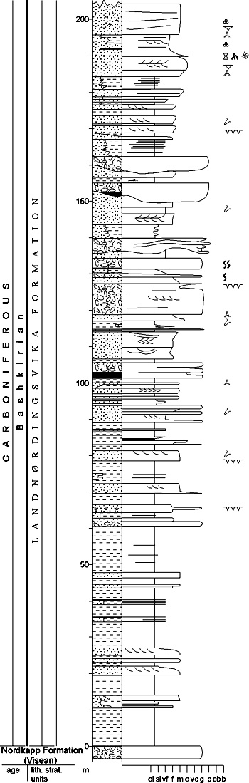
Fig. 2-91: Stratigraphic section CP-69a. Stratotype for: Landnørdingsvika Formation. Locality: Landnørdingsvika. Reference: Gjelberg 1981 The ratio of marine influenced sediment increases upwards, together with increasing carbonate content. The top of the formation has been placed at the first appearance of thick carbonate beds. Environmental interpretations have also been given by Gjelberg (1978), Gjelberg & Steel (1981, 1983) and Worsley et al. (in press). Back to top KAPP KÅRE FORMATION (CP-70) 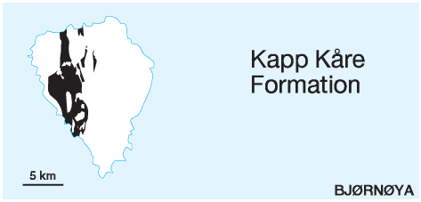 DISTRIBUTION shown on Fig. 2-05
STATUS OF UNIT: Formal FIRST USE OF NAME: Worsley & Edwards 1976 CURRENT DEFINITION: Worsley & Edwards 1976 SYNONYM(S) AND REFERENCE(S): "Ambigua limestone": Andersson 1900; "Kobbebukta Formation": Krasil'ščikov & Livšic 1974. Although Krasil'ščikov & Livšic (1974) publication with the name "Kobbebukta Formation" was issued earlier, the manuscripts were written simultaneously. This is valid for several units on Bjørnøya. We recommend the use of Worsley & Edward's (1976) nomenclature, because this is better established in the published literature (see Section 2.5.1). ORIGIN OF NAME: Kapp Kåre: A point on SW Bjørnøya TYPE SECTION (Fig. 2-94): Boundary stratotype: Landnørdingsvika - Kapp Kåre, SW Bjørnøya STRUCTURAL SETTING: West Bjørnøya Trough DEPOSITIONAL AGE: Bashkirian - Moscovian DATING METHOD: Fusulinids REFERENCE(S) FOR AGE: Simonsen 1988 (unpubl.) OVERLYING UNIT(S): Kapp Hanna Formation, Miseryfjellet Formation UNDERLYING UNIT(S): Landnørdingsvika Formation SUPERIOR UNIT: Kapp Kåre Formation OTHER USE OF NAME: None THICKNESS: Up to 200 m (composite) MAIN LITHOLOGIES: Cherty limestone, shale, sandstone, intraformational conglomerate LOWER BOUNDARY DEFINITION: The transition with the underlying coarse-clastic dominated Landnørdingsvika Formation is marked by the disappearance of thick conglomerates and the introduction of carbonates. The boundary is defined at the base of the first distinct carbonate bed. 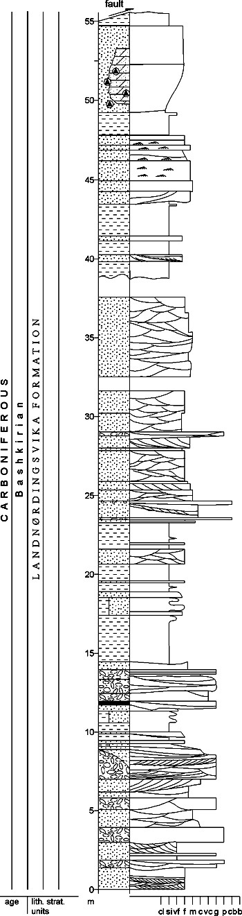
Fig. 2-92: Stratigraphic section CP-69b. Hypostratotype for: Landnørdingsvika Formation. Locality: Kobbebukta. Reference: Gjelberg, J.G. (unpubl.) DESCRIPTION: The formation is fully developed and well exposed, but poorly accessible, in the cliffs of andnørdingsvika on the southwestern coast of Bjørnøya. More accessible, although faulted, exposures show incomplete sections through the three members of the formation in Kobbebukta on the northern coast. For more detail see the Bogevika, Efuglvika and Kobbebukta members. Kirkemo (1979, unpubl.) provided detailed descriptions. Bogevika Member (CP-71) STATUS OF UNIT: Formal FIRST USE OF NAME: Worsley & Edwards 1976 CURRENT DEFINITION: Worsley & Edwards 1976 SYNONYM(S) AND REFERENCE(S): None ORIGIN OF NAME: Bogevika (transl. "The Bow Bay"): A bay on SW Bjørnøya TYPE SECTION (Fig. 2-94): Stratotype: Landnørdingsvika - Kapp Kåre, SW Bjørnøya DEPOSITIONAL AGE: Bashkirian - Early Moscovian DATING METHOD: Fusulinids REFERENCE(S) FOR AGE: Simonsen 1988 (unpubl.) OVERLYING UNIT(S): Efuglvika Member UNDERLYING UNIT(S): Landnørdingsvika Formation SUPERIOR UNIT: Gipsdalen Formation OTHER USE OF NAME: None THICKNESS: 92 m in stratotype MAIN LITHOLOGIES: Limestone, dolomite, sandstone, shale LOWER BOUNDARY DEFINITION: See Kapp Kåre Formation DESCRIPTION: In type section both upwards coarsening and upwards fining rhythmites are seen (Fig. 2-93): a significant sandstone content decreases upwards as first shales and then limestones become more prominent. Many beds here have greyish-red or variegated green-red colours; caliche horizons are common in the lower parts of the member, but biomicrites with marine faunas increase upwards to the junction with the overlying, totally limestone-dominated Efuglvika Member. Northern coastal exposures in Kobbebukta show less sandstone, a more shaley grey development and more marine influence. 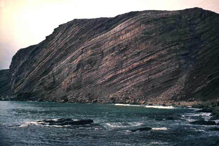
Fig. 2-93: Coarsening-upward unit in the Bogevika Member, Kobbebukta, Bjørnøya. Photo: D. Worsley The rhythmic development of the unit also displays numerous karst and discontinuity surfaces, suggesting an interplay of local tectonic activity with ongoing regional sealevel rise (Kirkemo 1979, unpubl.; Worsley et al, in press). 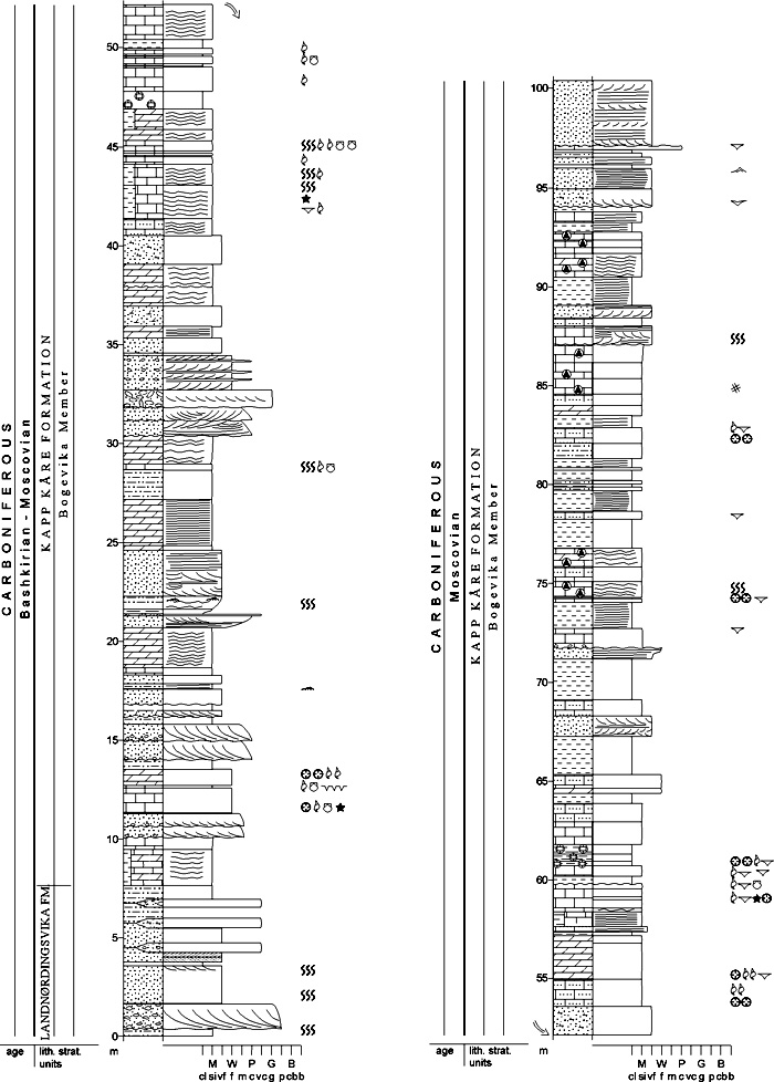
Fig. 2-94: Stratigraphic section CP-70/71. Boundary stratotype for: Kapp Kåre Formation. Stratotype for: Bogevika Member. Locality: Landnørdingsvika - Kapp Kåre. Reference: Worsley, D. (in press), modified from Kirkemo 1979 (unpubl.) Efuglvika Member (CP-72) STATUS OF UNIT: Formal FIRST USE OF NAME: Worsley & Edwards 1976 CURRENT DEFINITION: Worsley & Edwards 1976 SYNONYM(S) AND REFERENCE(S): None ORIGIN OF NAME: Efuglvika = ærfuglvika (transl. "The Eider Duck Bay"): A bay on western Bjørnøya TYPE SECTION (Fig. 2-95): Stratotype: Landnørdingsvika - Kapp Kåre, SW Bjørnøya DEPOSITIONAL AGE: Early Moscovian DATING METHOD: Fusulinids REFERENCE(S) FOR AGE: Simonsen 1988 (unpubl.) OVERLYING UNIT(S): Kobbebukta Member, locally Kapp Hanna Formation UNDERLYING UNIT(S): Bogevika Member SUPERIOR UNIT: Kapp Kåre Formation OTHER USE OF NAME: None THICKNESS: 77 m in stratotype MAIN LITHOLOGIES: Cherty limestone LOWER BOUNDARY DEFINITION: The Efuglvika Member starts where the succession of the Kapp Kåre Formation becomes dominated by limestones. Shales and sandstones, building up the major part of the underlying Bogevika Member, occur only as thin intercalations between limestones above the boundary. DESCRIPTION: Thinly bedded to massive cherty limestones show textures ranging from wackestone to grainstone. Both discontinuity and karstic surfaces are common, but stenohaline marine faunas occur throughout. The unit typically consists of a series of upwards coarsening rhythmites passing from bioturbated chert-rich wackestones with Thalassinoides burrows up into chert-free grainstones, sometimes with clearly erosive or karstified tops. Some small phylloid/bryozoan build-ups occur locally uppermost. 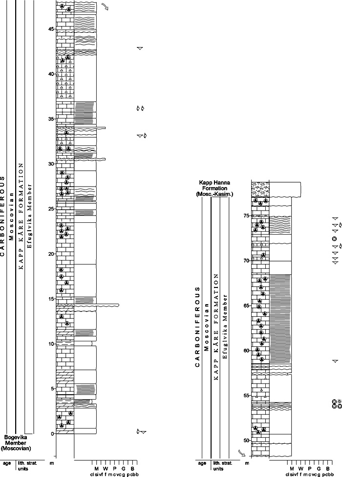
Fig. 2-95: Stratigraphic section CP-72. Stratotype for: Efuglvika Member. Locality: Landnørdingsvika - Kapp Kåre. Reference: Worsley, D. (in press), modified from Kirkemo 1979 (unpubl.) Rhythmicity, discontinuity surfaces, karst and chert dikes indicate ongoing local tectonic activity during relative high stand with generally open marine conditions. Kobbebukta Member (CP-73) STATUS OF UNIT: Formal FIRST USE OF NAME: Here CURRENT DEFINITION: Here, after Kirkemo 1979 (unpubl.) SYNONYM(S) AND REFERENCE(S): None ORIGIN OF NAME: Kobbebukta (transl. "The Seal Bay"): A bay on northern Bjørnøya TYPE SECTION (Fig. 2-96): Stratotype: Kobbebukta, northern Bjørnøya DEPOSITIONAL AGE: Late Moscovian DATING METHOD: Fusulinids REFERENCE(S) FOR AGE: Simonsen 1988 (unpubl.) OVERLYING UNIT(S): Kapp Hanna Formation UNDERLYING UNIT(S): Efuglvika Member SUPERIOR UNIT: Kapp Kåre Formation OTHER USE OF NAME: "Kobbebukta Formation": Krasil'ščikov & Livšic 1974. Although Krasil'ščikov & Livšic's (1974) publication with the name "Kobbebukta Formation" was issued earlier, the manuscripts were written simultaneously. This is valid for several units on Bjørnøya. We recommend the use of Worsley & Edward's (1976) nomenclature, because this is better established in the published literature (see Section 2.5.1). THICKNESS: Up to 45 m (stratotype) MAIN LITHOLOGIES: Conglomerate, limestone LOWER BOUNDARY DEFINITION: The boundary is defined where distinctive intraformational conglomerates rest with an erosive contact on the underlying bedded limestones and cherts of the Efuglvika Member. 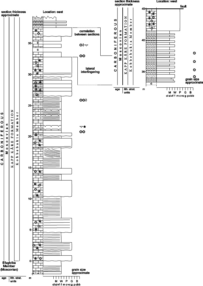
Fig. 2-96: Stratigraphic section CP-73. Stratotype for: Kobbebukta Member. Locality: Kobbebukta. Reference: Worsley, D. (in press), modified from Kirkemo 1979 (unpubl.) DESCRIPTION: The conglomerates were deposited both subaerially and in submarine debris flows and locally infill small half-grabens formed in the uppermost Efuglvika Member. Interbedded limestones, shales and siltstones contain marine faunas. Exposures on the SW coast show a much thinner development of only a few metres of debris flows; alternatively the Kapp Hanna Formation's extraformational conglomerates infill small fault-controlled depressions cutting directly into the Efuglvika Member carbonates. Synsedimentational tectonism reflected by the member's conglomerates reflects formation of an exposed block over the eastern parts of present-day Stappen High. Eroded material was transported westwards into the West Bjørnøya major half-graben through a series of small gullies; these reflect drainage control on the generally westwards-dipping topography by sets of small faults conjugate to the main N-S directed block faulting (Worsley et al., in press). Back to top KAPP HANNA FORMATION (CP-74) 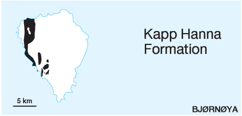 DISTRIBUTION shown on Fig. 2-05
STATUS OF UNIT: Formal FIRST USE OF NAME: Krasil'ščikov & Livšic 1974 CURRENT DEFINITION: Worsley & Edwards 1976 SYNONYM(S) AND REFERENCE(S): "Yellow sandstone": Andersson 1900 ORIGIN OF NAME: Kapp Hanna: A point on western Bjørnøya TYPE SECTION (Fig. 2-98, Fig. 2-99): Boundary stratotype: Efuglvika N, SW Bjørnøya. Unit stratotype: Kobbebukta - Nordvestbukta, NW Bjørnøya (composite section) STRUCTURAL SETTING: West Bjørnøya Trough DEPOSITIONAL AGE: Late Moscovian - ?Kasimovian DATING METHOD: Fusulinids REFERENCE(S) FOR AGE: Simonsen 1988 (unpubl.), Nilsson 1994 (unpubl.) OVERLYING UNIT(S): Kapp Dunér Formation UNDERLYING UNIT(S): Kapp Kåre Formation; see also 'description' SUPERIOR UNIT: Gipsdalen Group OTHER USE OF NAME: None THICKNESS: Up to ca. 150 m MAIN LITHOLOGIES: Sandstone, shale, conglomerate, dolomite LOWER BOUNDARY DEFINITION: The base is defined by a basal extraformational conglomerate overlying various lithologies of the Kapp Kåre Formation. The conglomerate contains clasts of various underlying lithologies and is the result of fault movements giving rise to an angular uncoformity at the boundary. 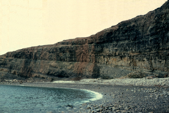
Fig. 2-97: Syntectonically deposited sandstones with erosive base in the Kapp Hanna Formation, Kapp Hanna, Bjørnøya. Photo: D. Worsley DESCRIPTION: Much of the formation shows both upwards coarsening and upwards fining intercalations of sandstone and shale deposited in coastal environments. More complex developments are seen at several levels where gullies cut down into pre-existing deposits, in some cases with marked angular unconformity (Fig. 2-97); these gullies are associated with intraformational faulting and are infilled by extraformational conglomerates deposited by both ephemeral stream flood deposits and submarine debris flows. Clast composition varies markedly stratigraphically and geographically. An increasing frequency of clasts derived from progressively older stratigraphic units upwards and southwards on Bjørnøya reflects exhumination of strata from the newly developed block over the East of the island and the greater proximity of southern exposures to this block. Most of the faults seen cutting the Upper Palaeozoic succession on Bjørnøya today apparently formed during deposition of the Kapp Hanna Formation. 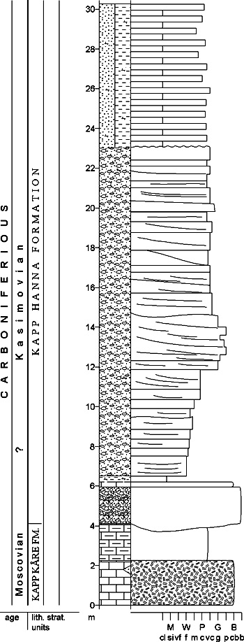
Fig. 2-98: Stratigraphic section CP-74a. Boundary stratotype for: Kapp Hanna Formation. Locality: Efuglvika. Reference: Worsley et al. (in prep.) Basal conglomerates of the Kapp Hanna Formation locally infill faulted relief in the top of the Kapp Kåre Formation (e.g. at Raudnuten); at Alfredfjellet and Hambergfjellet local half-grabens contain local representatives of the Kapp Hanna Formation unconformably overlying the Ymerdalen (Pre-Old Red), Røedvika and Nordkapp formations; suspected basal conglomerates of the Kapp Hanna Formation rest directly on the Pre-Old Red southwest of Miseryfjellet. The E-W trending grabens and half-grabens seen in the southern cliffs represent the conjugate minor fault systems referred to under the Kobbebukta Member. 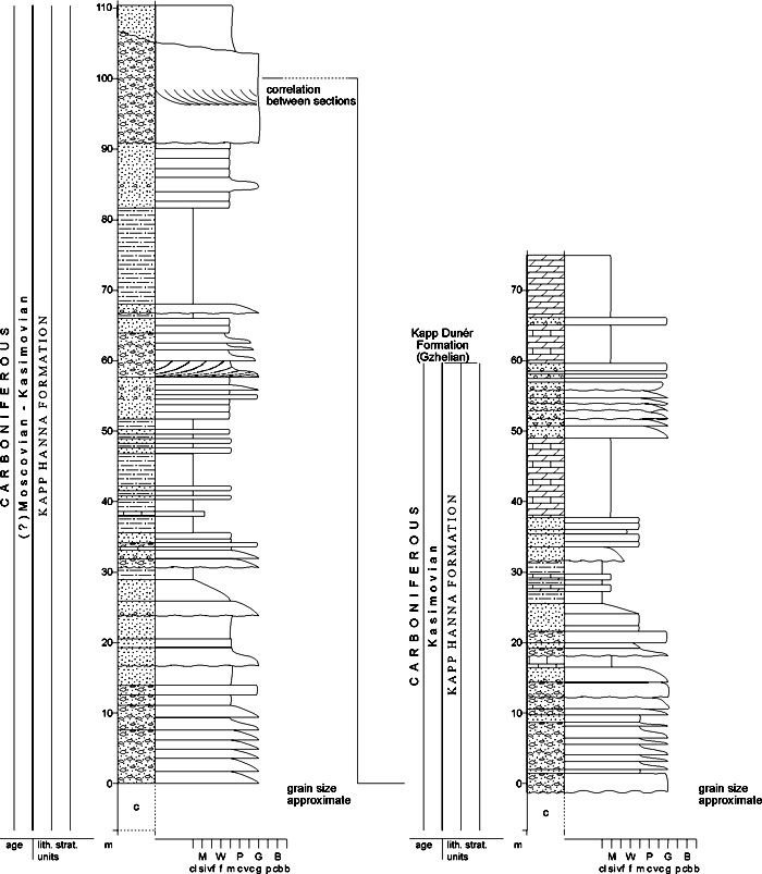
Fig. 2-99: Stratigraphic section CP-74b. Composite unit stratotype for: Kapp Hanna Formation. Locality: Kobbebukta - Nordvestbukta. Reference: Worsley et al. (in prep.) Back to top KAPP DUNÉR FORMATION (CP-75)  DISTRIBUTION shown on Fig. 2-05
STATUS OF UNIT: Formal FIRST USE OF NAME: Krasil'ščikov & Livšic 1974 CURRENT DEFINITION: Worsley & Edwards 1976 SYNONYM(S) AND REFERENCE(S): "Fusulina limestone": Andersson 1900 ORIGIN OF NAME: Kapp Dunér: A point on northwestern Bjørnøya TYPE SECTION (Fig. 2-103, Fig. 2-104): Boundary stratotype: Snyta, NW Bjørnøya. Unit stratotype: Amfiet-Teltvika-Kapp Elisabeth, NW Bjørnøya (composite section) STRUCTURAL SETTING: West Bjørnøya Trough DEPOSITIONAL AGE: Middle Gzhelian - Asselian DATING METHOD: Fusulinids REFERENCE(S) FOR AGE: Simonsen 1988 (unpubl.), Nilsson 1994 (unpubl.) OVERLYING UNIT(S): Hambergfjellet Formation, ?Miseryfjellet Formation UNDERLYING UNIT(S): Kapp Hanna Formation SUPERIOR UNIT: Gipsdalen Group OTHER USE OF NAME: None THICKNESS: Up to ca. 90 m MAIN LITHOLOGIES: Dolomite, limestone LOWER BOUNDARY DEFINITION: The base is defined by the onset of palaeoaplysinid reef carbonates or associated bedded dolomites above the alternating carbonate/clastic succession of the underlying Kapp Hanna Formation. 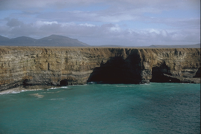
Fig. 2-100: A 30 m high cliff at Kapp Dunér (Bjørnøya) showing shelf carbonate deposits of the Kapp Dunér Formation with lenticular Palaeoaplysina buildups. Photo: G.B. Larssen 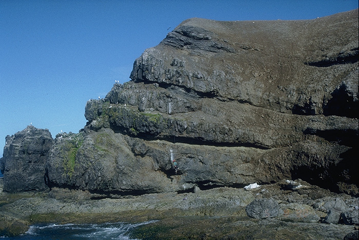
Fig. 2-101: Vertically stacked Palaeoaplysina buildups at Amfiet, near Kapp Dunér (Bjørnøya) in the Kapp Dunér Formation. Photo: G.B. Larssen DESCRIPTION: Both tabular and lenticular palaeoaplysinid bioherms (Fig. 2-100, Fig. 2-101) as well as fore-reef carbonates (Fig. 2-102) occur in the lower parts of formation, often with marked karstic tops. A significant hiatus around the latest Gzhelian to early Asselian interval is marked by a particularly prominent karst surface. Upper (bedded dolomitic limestone) parts of the formation onlap the topography caused by synsedimentary tectonism responsible for deposition of the Kapp Hanna Formation. 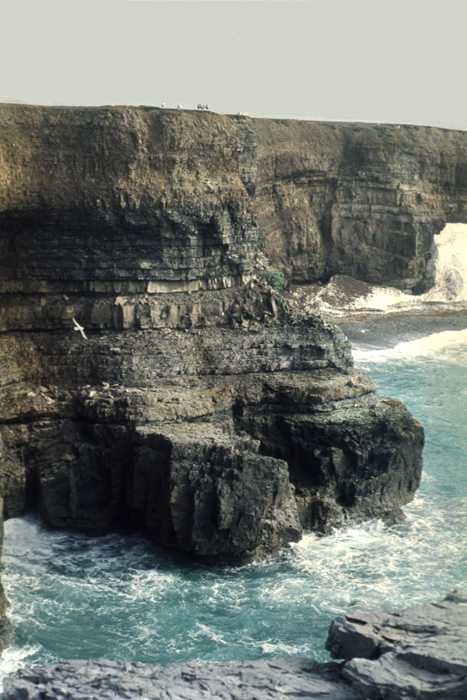
Fig. 2-102: Forereef facies in the Kapp Dunér Formation, Kapp Dunér, Bjørnøya. Photo: D. Worsley Mineralogical and sedimentological descriptions of different aspects of the formation are given by Siedlecka (1972a, 1975), Lønøy (1988), Stemmerik & Larssen (1994), Stemmerik et al. (1994), Worsley et al. (in press). 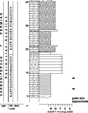
Fig. 2-103: Stratigraphic section CP-75a. Boundary stratotype for: Kapp Dunér Formation. Locality: Snyta. Reference: Simonsen 1988 (unpubl.) Immediately post-depositional uplift produced tilting and erosion of the formation's topmost beds. Marked karstic features in the type area are infilled with conglomerates showing lithologies similar to those of the Miseryfjellet Formation. Representatives of the formation in small grabens in the island's southern cliffs are overlain by the Hambergfjellet Formation (Simonsen 1988, unpubl.; Worsley et al., in press). 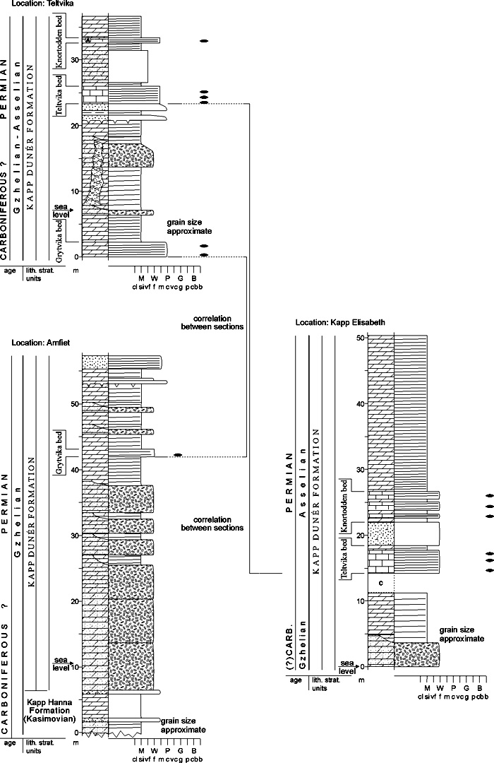
Fig. 2-104: Stratigraphic section CP-75b. Composite unit stratotype for: Kapp Dunér Formation. Locality: Amfiet - Teltvika - Kapp Elisabeth. Reference: Simonsen 1988 (unpubl.) Back to top |