Sele Formation
updated to follow: Stratigraphic Guide to the Rogaland Group, Norwegian North Sea. Harald Brunstad, Felix M. Gradstein, Jan Erik Lie, Øyvind Hammer, Dirk Munsterman, Gabi Ogg, and Michelle Hollerbach. Newsletter on Stratigraphy, vol 46/2 pp137-286, 2013.
Rogaland Group
Members of the Formation
Fiskebank Member | Forties Member | Hermod Member | Sula Member |
Unit definition
The Sele Formation is attributed to the laminated, non tuffaceous shales located
stratigraphically between the Lista and Balder formations (Fig. 95).
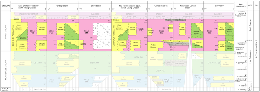
Fig. 95. Lithostratigraphic summary chart of the Sele Formation (color) with
members.
|
Name
The Sele Formation was given name by Deegan & Scull (1977).
Derivatio nominis
The Formation is named after the Sele High off the coast of southwest Norway.
Type well
UK well 21/10-1. Depth 2131 to 2100 m RKB. Coordinates N 57°43'50.37", E
00°58'29.19". No cores.
Reference wells
Norwegian well 31/2-6 (Fig. 96). Depth 1225-1167 m RKB. Coordinates N 60°54'13.57", E 03°38'49.43". No
cores.
Norwegian well 16/5-1 (Fig. 97). Depth 1557-1580 m RKB. Coordinates N 58°38'53.66", E 02°29'39.69". No
cores.
Norwegian well 7/11-2 (Fig. 98). Depth 2996-3124 m RKB. Coordinates N 57°04'15.20", E 02°24'26.50".
Cores: Core 1.
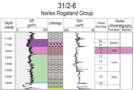
Fig. 96. Well 31/2-6 Composite log Rogaland Group. Stratigraphic position of the
Sele Formation is outlined in stratigraphic column to the right.
|
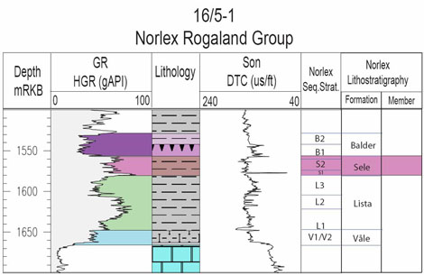
Fig. 97. Well 16/5-1 Composite log Rogaland Group. Stratigraphic position of the
Sele Formation is outlined in stratigraphic column to the right.
|
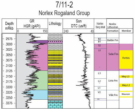
Fig. 98. Well 7/11-2 Composite log Rogaland Group. Stratigraphic position of the
Sele Formation is outlined in stratigraphic column to the right.
|
Composition
The formation consists of montmorillinite-rich shales and siltstones which are medium
to dark grey or greenish-grey. The sediments are finely laminated and carbonaceous,
with minor interbeds of laminated sandstones which are frequently glauconitic.
Scattered tuffaceous beds are also observed.
Core photos from Norwegian well 25/7-5 and a core description of Upper Sele Formation
Norwegian well 7/11-A5, Central Trough are shown in Figs. 99 and 100.
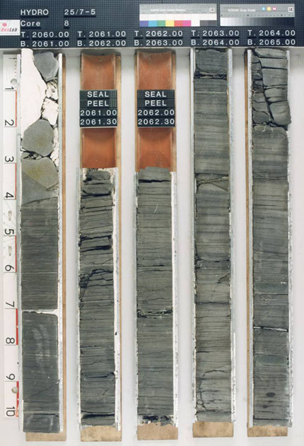
Fig. 99. Core photo displaying dark grey non-bioturbated shales of the Sele
Formation in well 25/7-5. Photo from NPD Fact Pages at
http://www.npd.no.
|
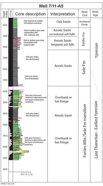
Fig. 100. Core description log from the Sele Formation Rogaland Group well 7/11-A5.
|
Wire line log characterization
The shales of the Sele Formation are generally characterized by intermediate to high
gamma readings. Sonic logs spikes with high acoustic velocity can be related to
thin beds or nodules of carbonate.
Upper Boundary
The upper boundary of the formation is taken at an abrupt decrease in gamma-ray
response and an increase in velocity when going upwards into the Balder Formation.
Lithologically an abrupt increase in the number of tuffaceous beds in the transition
to the Balder Formation can be seen.
Lower boundary
The lower boundary of the Sele Formation is usually well defined when the lower parts
of this formation or the upper parts of the underlying
Lista Formation are not sandy.
Typically the boundary can be seen as an abrupt upwards increase in the gamma-ray
response from the Lista Formation, often with a well defined peak in the lowest part
of the Sele Formation. Lithologically, the boundary can be seen as an abrupt
transition from green-grey, bioturbated mudstones of the Lista Formation into dark
grey to black laminated shales with only occasional bioturbation.
Where the transition is sandy, an overall increase in gamma-readings is seen when
going from Lista into the Sele Formation.
Thickness
The thickness of the Sele Formation is variable. It is 31 m thick in the type well
UK 21/10-1, and 58 m thick in the reference well 31/2-6. Including sandstone members
the Sele Formation has a thickness of 220 m in well 7/11-3, and 243 m in well
25/1-4.
Seismic characterization
The Top Sele/Base Balder reflector
The top of the Sele Formation (Near Top S2) is often characterized by a marked
acoustic
impedance drop, when going from the high velocity tuffaceous shales in B1 (lower
Balder Formation) and into the lower velocity shales of the Sele Formation. However
the Top Sele Formation can sometimes be difficult to pick and may be masked by the
effect of top Balder Formation tuff (B1 zone).
Base Sele/Top Lista reflector
The base of the Sele Formation is generally the seismic surface that is easiest to
pick. It can be related to the chronostratigraphic surface that marks the boundary
between the organic rich shales of the Sele Formation and the bioturbated shales of
the Lista Formation. The seismic marker seems is associated with a low velocity spike
(corresponding with high gamma spike) in the lowermost part of the Sele Formation,
seen as a negative amplitude event. However, the character and amplitude of this
event changes laterally.
Age
Latest Paleocene-Earliest Eocene (Late Thanetian-Earliest Ypresian).
Biostratigraphy
Organic-walled microfossils: The top of the Sele Formation agrees with the top
Acme
Cenodinium wardenense. The body of the Sele Formation contains the top of
Apectodinium augustum (Fig. 101), top of Cenodinium dartmoorium, and
top frequent
Inaperturopollenites spp. and Taxodiaceae spp. The base of the Sele
Formation agrees
with the base of Apectodinium augustum. Hence, the Sele Formation is assigned
to the
A. augustum Zone plus the lower D. oebisfeldensis Zone, using
dinoflagellates.
Shelly microfossils: The Sele Formation reflects and corresponds to closure of
passages to and from the North Sea, resulting in a freshening of surface water mass
and dysaerobia in the deeper water mass. Hence, bottom dwellers are rare and limited
to
few agglutinated foraminiferal taxa, including isolated Trochamminoides spp.
Diatoms
are well adapted to freshening surface watermass, and pyritized diatoms of mostly
Fenestrella antique are common.
The Sele Formation is assigned to the upper part of Zone NSR2B - Reticulophragmium
pauperum and the lower part of the Fenestrella antiqua Zone of Gradstein &
Bдckstrцm (1996) using shelly microfossils.
The above biostratigraphy shows that the age of the Sele Formation is late Thanetian
through early Ypresian, straddling the Paleocene-Eocene boundary. The disappearance
of Apectodinium augustum in the North Sea Basin coincides with the standard
Paleocene-Eocene boundary, as defined by the onset of a pronounced negative carbon
isotope excursion (CIE), which allows global correlation of a wide variety of marine
and terrestrial strata. Note that this formal, international definition of the
Paleocene-Eocene boundary places the lower Sele Formation in the uppermost Paleocene
and the upper Sele Formation in the lowermost Eocene.
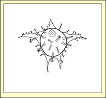
Fig. 101. Example of diagnostic microfossil in the Sele Formation:
Apectodinium augustum (Harland 1979c) Lentin and Williams 1981. Dorsal view.
Holotype
dimensions: pericyst length (excluding horns) = 63.75 µm, pericyst width (excluding
horns) = 66.25 µm. From the ODP Drilling Program at
http://www-odp.tamu.edu.
|
Correlation and subdivision
The Sele Formation is well expressed and easy to recognize from wire line logs in
most of the Norwegian North Sea. In northern parts of the Sogn Graben and Måløy
Terrace, the Sele Formation is more difficult to distinguish from the Lista
Formation, and in the north easternmost parts the two formations appear to
interfinger. This interfingering could be a result of less anoxic conditions during
deposition of the Sele Formation in this area. Based on the sequence stratigraphic
zonation established by Mudge & Bujak (1996) with high gamma shales associated with
specific chronostratigraphic bioevents, the Sele Formation can be subdivided into a
lower (S1) and an upper (S2) part. The base of the S1 zone is taken at the high gamma
peak near the base of the Sele Formation, which is associated with the top of
impoverished
agglutinated assemblage. The boundary between the two zones is picked at the
Apectodinum spp Acme, and is often associated with a marked high gamma peak
internally in the Sele Formation. The top of the S2 zone is taken at the common
Ceratopsis wardenense.
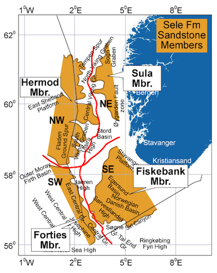
The Sele Formation contains four sandy members (Fig. 102). The
Fiskebank Member found in the Norwegian Danish Basin in
the Siri Valley and southeastern flank of the
Central Trough fairway, and the Sula Member found along
the eastern flank of the
Måløy Terrace and Sogn Graben, are believed to have an eastern provenance. The
Forties
Member in the Central Trough and the Hermod Member in
the Viking Graben have a western provenance.
These sandy members are coded according to whether they are found in Sele zone S1 or
S2: Hermod S1 and Hermod S2; and Forties S1 and Forties S2, etc.
Links to member descriptions
Geographic distribution
The Sele Formation is present in most of the areas where Paleocene sediments are
present in the Central and northern North Sea (Fig. 102). Only along the eastern
flanks where Paleocene sediments are partly truncated, the Sele Formation is partly
or completely eroded. Distribution of the Sele Formation with its respective members
is shown below.
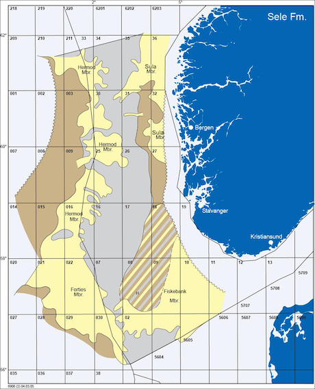
Fig. 102. Distribution of the Sele Formation and its sandstone members.
|
 |
Depositional environment
As earlier mentioned in Subchapters 1, 2 and 3 the Sele Formation was deposited in an
anoxic basin restricted by sills established as a response to regional uplift
(Wyville Thompson Ridge, Inversion ridge in the London - Brabant area and closing of
the earlier seaway passage in the Polish Trough). Accordingly the Sele Formation was
deposited during a period of general basin restriction in the North Sea basin, with
freshening of surface water (brackish) and dysoxic to anoxic bottom water. This had
an extinctive effect on benthonic organisms, and hence sediments remained undisturbed
after deposition giving laminated, non bioturbated sediments upon burial.


