 |
|
|
|
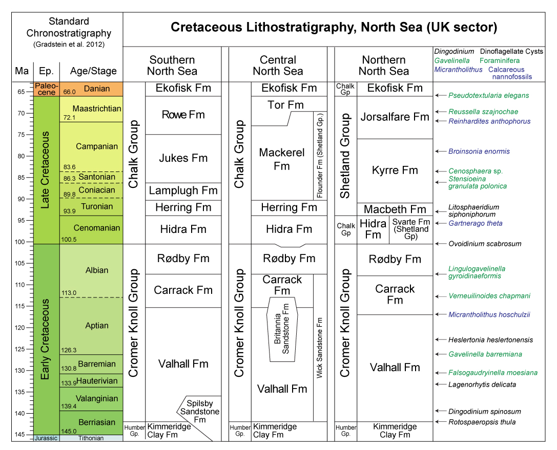
Cretaceous Lithostratigraphy, North Sea | Chalk Group Subdivisions | Maps for UKSector
(Image is clickable)

(Image is clickable)
|
 |
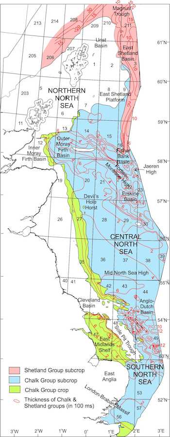 |
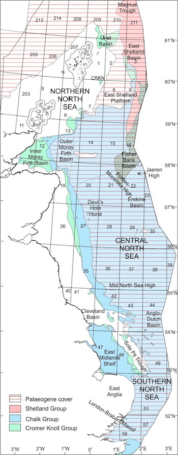
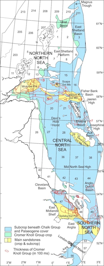
| Geological map showing the distribution of the Cromer Knoll, Chalk and Shetland Groups in the UK sector of the North Sea at crop and beneath Paleogene and Quaternary strata. The map is 1:250,000-resolution; data sourced from BGS DiGRock 250k_v3. | Distribution and thickness of the Cromer Knoll Group and main component sandstones (derived from Cameron et al., 1992, fig. 79; Gatliff et al., fig. 39; Andrews et al., 1990, fig. 34; Johnson et al., 1993, fig.47). | Distribution and thickness of the Chalk and Shetlands Groups (derived from Cameron et al., 1992, fig. 82; Gatliff et al., fig. 43; Andrews et al., 1990, fig. 38; Johnson et al., 1993, fig. 50). |
| Group | Formation | Member | Type well | Interval | Location | Reference well | Interval | Location | |
| Cretaceous | Shetland | Hardråde | 30/11-3 | 2892-2601 m | N 60°02'38.59, E 02°32'15.47 | 31/6-2 | 968-978 m | N 60°34'58.24, E 03°54'55.76 | |
| Jorsalfare | 25/1-1 | 2997-2711 m | N 59°53'17.40, E 02°04'42.70 | 35/3-2 | 1665-1520 m | N 61°51'05.98, E 03°46'28.22'' | |||
| 24/9-1 | 3117-2752 m | N 59°16'09.48, E 01°47'31.18 | |||||||
| Kyrre | 25/1-1 | 3582-2997 m | N 59°53'17.40, E 02°04'42.70 | 35/3-2 | 2864-1665 m | N 61°51105.98, E 03°46'28.22 | |||
| 24/9-1 | 3638-3117 m | N 59°16'09.48, E 01°41'31.18 | |||||||
| 30/11-3 | 3162-2892 m | N 60°02'38.59, E 02°31'15.47 | |||||||
| Piggvar (new) | 6204/11-1 | 2088-2001m | N 62°11'16.96, E 04°23'57.85 | 6204/10-1 | 2046-1860m | N 62°03'20.50, E 04°15'36.60 | |||
| 6204/10-2 R | 1895.5-1868 m | N 62°02'41.24, E 04°07'04.59 | |||||||
| Rødspette (new) | 35/9-3 ST | 1958.5-1868 m | N 61°28'51.76, E 03°58'30.17 | 36/7-3 | 1908.5-1843 m | N 61°25'33.12, E 04°2'59.61 | |||
| Tryggvason | 25/1-1 | 3790-3582 m | N 59°53'17.40, E 02°04'42.70 | 35/3-2 | 3190-2864 m | N 61°5r05.98, E 03°46'28.22 | |||
| 24/9-1 | 3783-3638 m | N 59°16'09.48, E 01°47'31.18 | |||||||
| 30/11-3 | 3207-3162 m | N 60°02'38.59, E 02°32'15.47 | |||||||
| Blodøks | 25/1-1 | 3807-3790 m | N 59°53'17.40, E 02°04'42.70 | 35/3-2 | 3207-3190 m | N 61°51'05.98, N 03°46'28.22 | |||
| 1/3-1 | 4371-4343 m | N 56°51'21.00, E 02°51'05.00 | |||||||
| Danish BO-1 | 2220-2213 m | N 55°48'02.22, E 04°34'18.66 | |||||||
| Svarte | 25/1-1 | 3995-3807 m | N 59°53'17.40, E 02°04'42.70 | 35/3-2 | 3447-3207 m | N 61°5r05.98, E 03°46'28.22 | |||
| 24/9-1 | 3992-3804 m | N 59°16'09.48, E 01°47'31.18 | |||||||
| Chalk | Tor | 1/3-1 | 3828-3354 m | N 56°51'21.00, E 02°51'05.00 | UK22/1-2A | 3245-2982.5 m | N 57°56'12.20, E 01°12'55.80 | ||
| UK29/25-1 | 2212-1869 m | N 56°18l10.00, E 01°5'48.80 | |||||||
| 1/9-1 | 3312-3104 m | N 56°24'05.07, E 02°54'06.49 | |||||||
| Hod | 1/3-1 | 4343-3828 m | N 56°51'21.00, E 01°51'05.00 | UK29/25-1 | 2225-2012 m | N 56°18'10.00, E 01°51'48.80 | |||
| 2/8-8 | 2601-2494 m | N 56°16'50.28, E 03°24'15.93 | |||||||
| Hidra | 1/3-1 | 4441-4371 m | N 56°51'21.00, E 02°51'05.00 | UK22/1-2A | 3783-3738 m | N 57°56'12.20, E 01°02'55.80 | |||
| UK29/25-1 | 2258.5-2228 m | N 56°18'10.00, E 01°51'48.80 | |||||||
| Danish BO-1 | 2275.5-2220 m | N 55°48' 02.22, E 04°34' 18.66 | |||||||
| Undifferentiated Shetland Group | 31/6-2 | 1128-978 m | N 60°43'58.24, E 03°54'55.76 | ||||||
| Cromer Knoll | Rødby | Danish Rødby-1 | 2/11-1 | 2910-2887 m | N 56°14'16.98, E 03°27'07.05 | ||||
| 2/7-15 | 3419-3401 m | N 56°23'46.82, E 03°18'54.63 | |||||||
| Agat (new status) | 35/3-4 | 3542-3345 m | N 61°51'54.54,E 03°52'26.99 | 35/3-5 | 3605-3219 m | N 61°47'46.71, E 03°54'44.01 | |||
| Sola | Danish 1-1 | 2898-2859 m | N 56°03'10, E 04°14'60 | 2/11-1 | 2988-2910 m | N 56°14'16.98, E 03°27'07.05 | |||
| 24/12-2 | 4043-3985 m | N 59°12'00.75, E 01o52'53.34 | |||||||
| Tuxen | Danish I-1 | 2986-2898 m | N 56°03'10, E 04°14'60 | 2/11-1 | 3063-2988 m | N 56°14'16.98, E 03°27'07.05 | |||
| 2/6-2 | 3935-3864 m | N 56°30'48.90, E 03°42'39.66 | |||||||
| Mime | 34/10-18 | 2351-2340 m | N 61°14'22.48, E 02°03'18.83 | 17/4-1 | 2122-2080 m | N 58°35'54.00, E 03°16'05.00 | |||
| åsgard | 2/11-1 | 3555-3063 m | N 56°14'16.98, E 03°27'07.05 | 17/11-2 | 2410-1802 m | N 58°06'54.91, E 03°22'09.81 | |||
| Danish I-1 | 3358-2986 m | N 56°03'10, E 04°14'60 | |||||||
| Rognkjeks (new) | 36/7-3 | 2796-2767 m | N 61°25'33.12 E 04°2'59.61 | 35/3-5 | 3684-3662 m | N 61°47'46.71, E 03°54'44.01 | |||
| Rognkall (new) | 6205/3-1 R | 4355-4327 m | N 62°57'08.62 E 05°56'38.11 | ||||||
| Steinbit (new) | 6204/11-2 | 2800m-2700m | N 62°11'50.47 E 04°26'37.67 | 6204/10-1 | 2670-2564m | N 62°03'20.50, E 04°15'36.60 | |||
| Ran (redefined) | 7/3-1 | 2412-2396 m | N 57°50'35.25, E 02°44'55.61 | 17/11-2 | 1802-1767 m | N 58°06'54.91, E 03°22'09.81 |
| home | previous page |