|
|
|
|
updated to follow: Stratigraphic Guide to the Cromer Knoll, Shetland and Chalk Groups of the North Sea and Norwegian Sea. Felix M. Gradstein & Colin C. Waters (editors), Mike Charnock, Dirk Munsterman, Michelle Hollerbach, Harald Brunstad, Øyvind Hammer & Luis Vergara (contributors). Newsletter on Stratigraphy, vol 49/1 pp71-280, 2016
Shetland Group, Kvitnos Formation
The Tumler Member is a new member developed in the upper part of the Kvitnos Formation in the Vøring Basin. It is characterised by sandstones and thin interbeds of mudstones of Late Cretaceous, Santonian age. It may be distinguished from the younger, sandstone-rich, Spekkhogger Member, developed in the overlying section of the Tumler Member type well 6707/10-1, by a thick (>100m) interval of mudstones.
The Tumler Member has a geographically more restricted distribution than the overlying Spekkhogger Member within the Vøring Basin. It is interpreted as being deposited under similar depositional processes i.e. mainly by episodic high density turbidity currents within a large scale submarine fan complex, that developed in response to rapid subsidence in the Vøring Basin.
Derivatio nominis: The name Tumler is derived from the Norwegian name for the bottle-nosed dolphin species Tursiops truncates. The species is a member of the sea going dolphin family (Delphinidae), and together with the killer whale Orca is the most numerous dolphin species on a world basis. The species has a cosmopolitan distribution from tropical to cold temperate waters, and extends as far north as the Norwegian Sea.
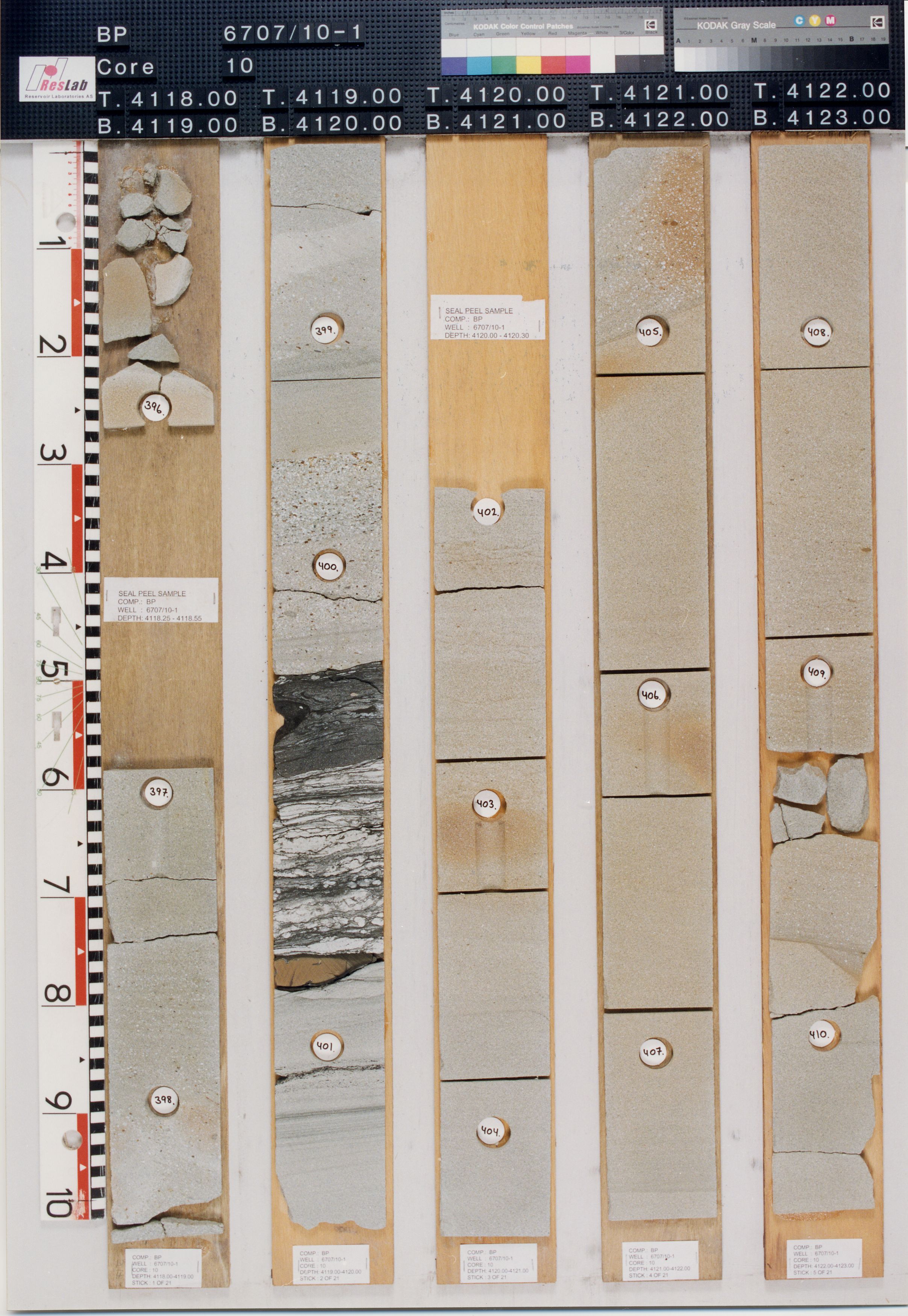
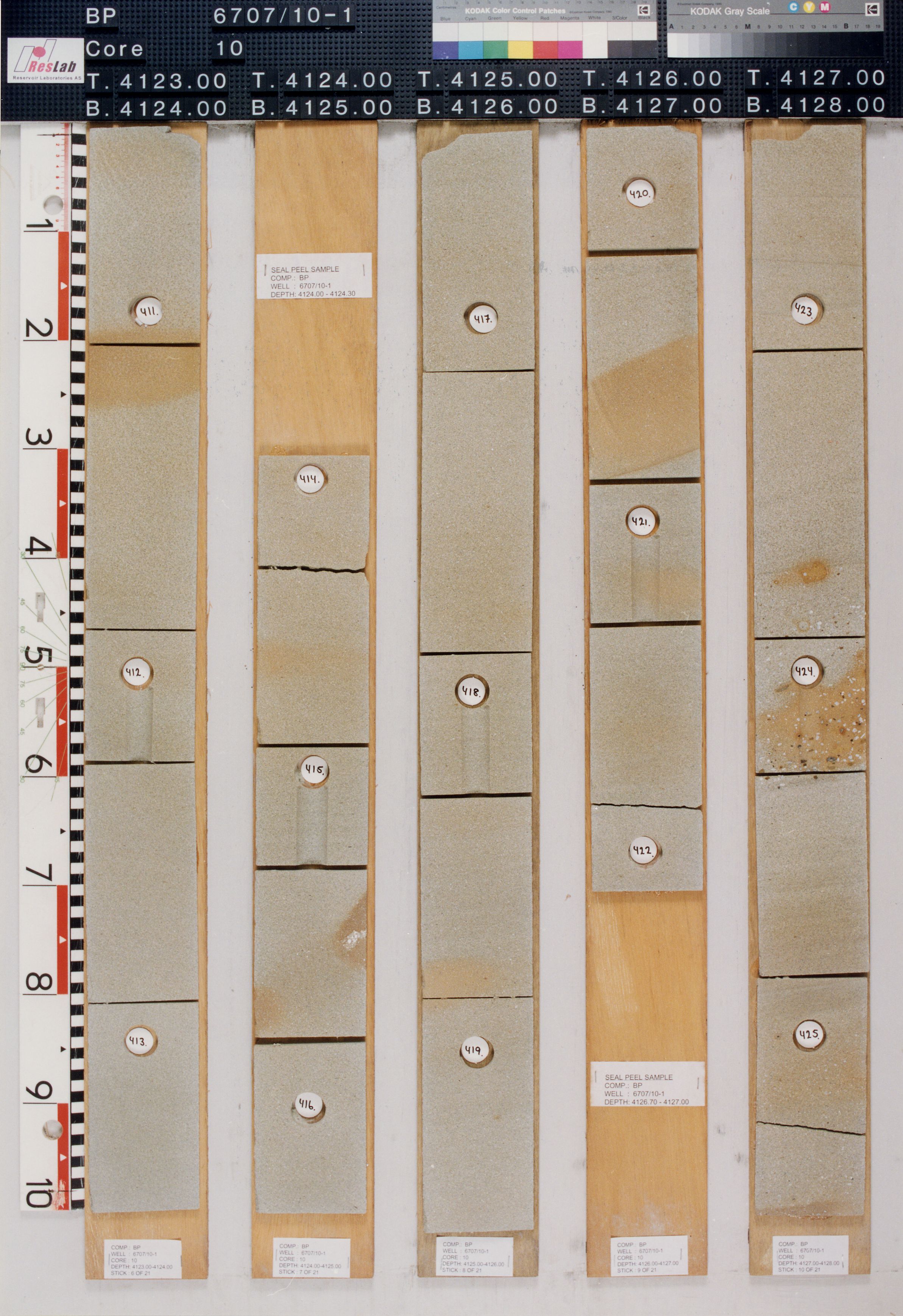
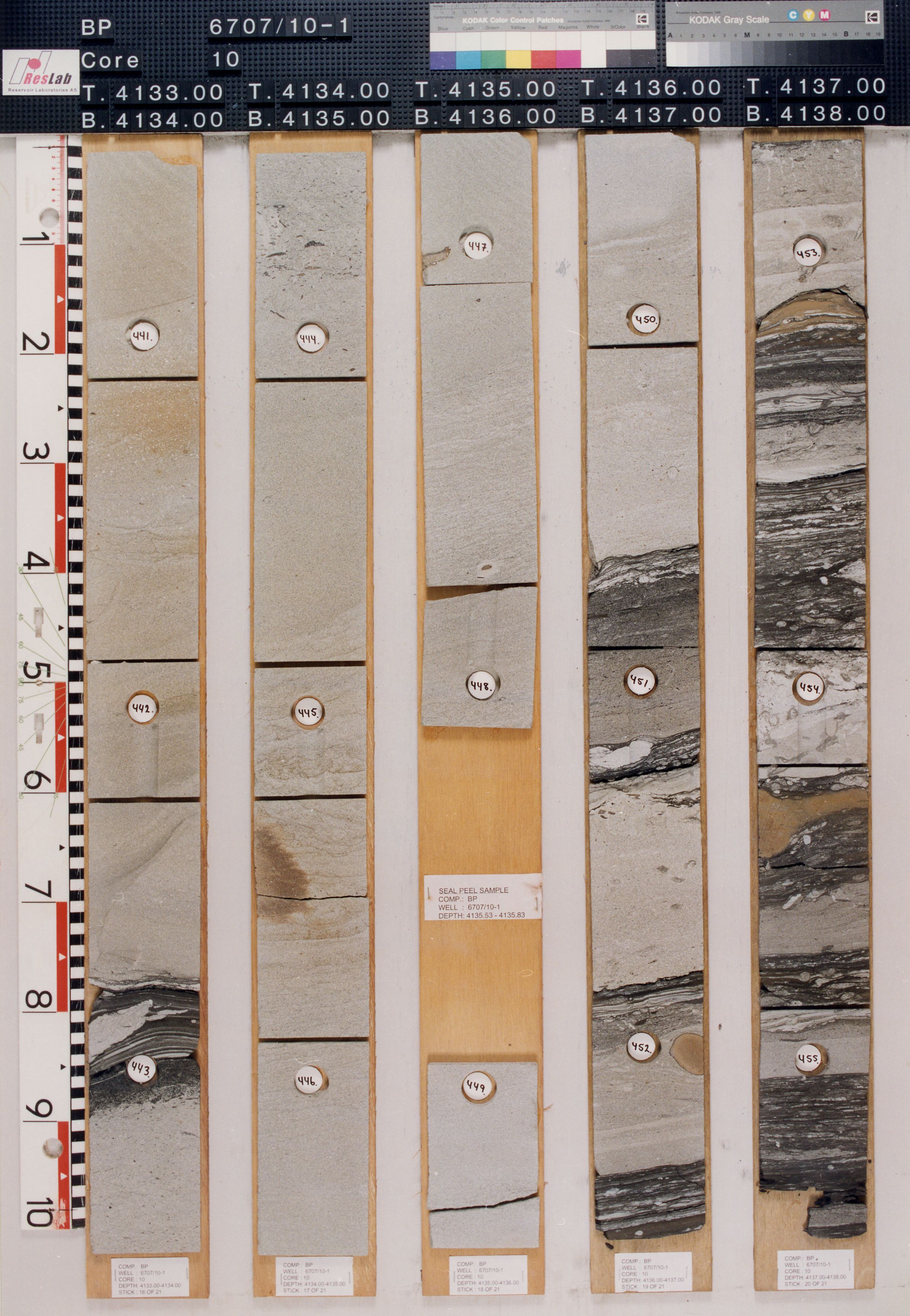
The Tumler Member mainly consists of sandstones with thin interbeds of mudstones and occasional limestone and dolomite stringers.
The sandstones are white - very light grey or medium light grey - dark grey in clour. Grains vary from very fine to coarse, predominantly fine to medium, locally very coarse. The grains are made of clear to translucent quartz, locally hard, predominantly loose, angular to sub-rounded, predominantly sub-angular to sub-rounded, moderately to well sorted. Sandstone cement is mostly siliceous, locally weak to moderately calcareous or kaolinitic, rarely dolomite. The sandstone may be silty, locally with argillaceous matrix, common glauconite in parts, micaceous, locally with common plant fragments, pyritic, with poor to moderate visible porosity.
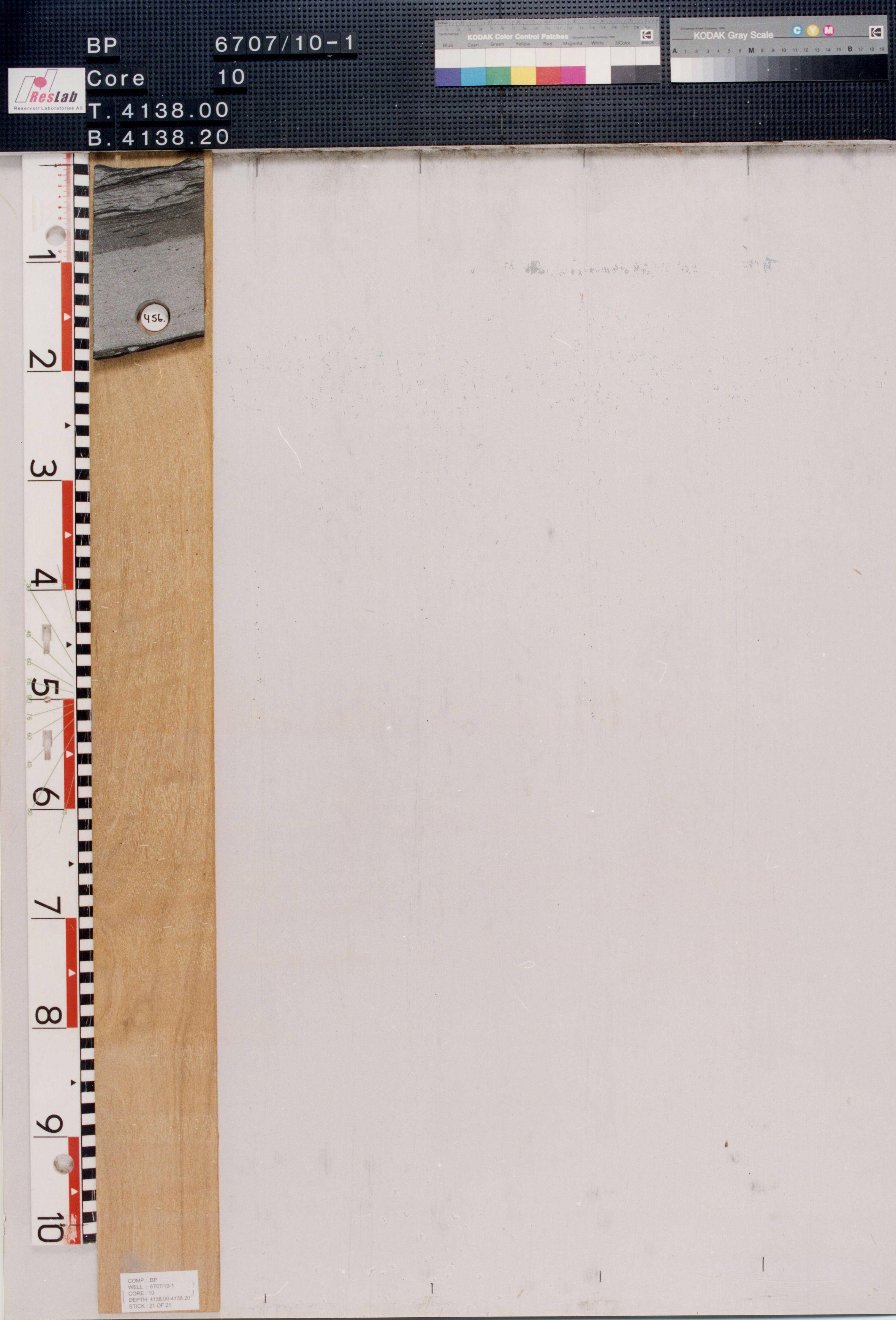
The mudstones are medium grey to brownish grey, rarely dark grey to olive black in colour. Texture is soft to firm, moderately hard, amorphous to sub-blocky, silty, commonly grading to siltstone or as thin laminae with sandstones, carbonaceous, slightly micro-micaceous, traces of very fine disseminated pyrite, trace glauconite, non to slightly calcareous, commonly grading to siltstones.
The occasional dolomite stringers are light brown to dark yellow brown, olive grey in part, moderately hard to brittle, argillaceous, occasionally sandy, crypto-crystalline grading to limestone.
The minor limestones are light grey, white, soft to firm, blocky, argillaceous or sandy.
Sandstones of the Santonian Tumler Member lie below those of the Campanian Spekkhogger Member and have a geographically more restricted distribution in the Vøring Basin, using available well data.
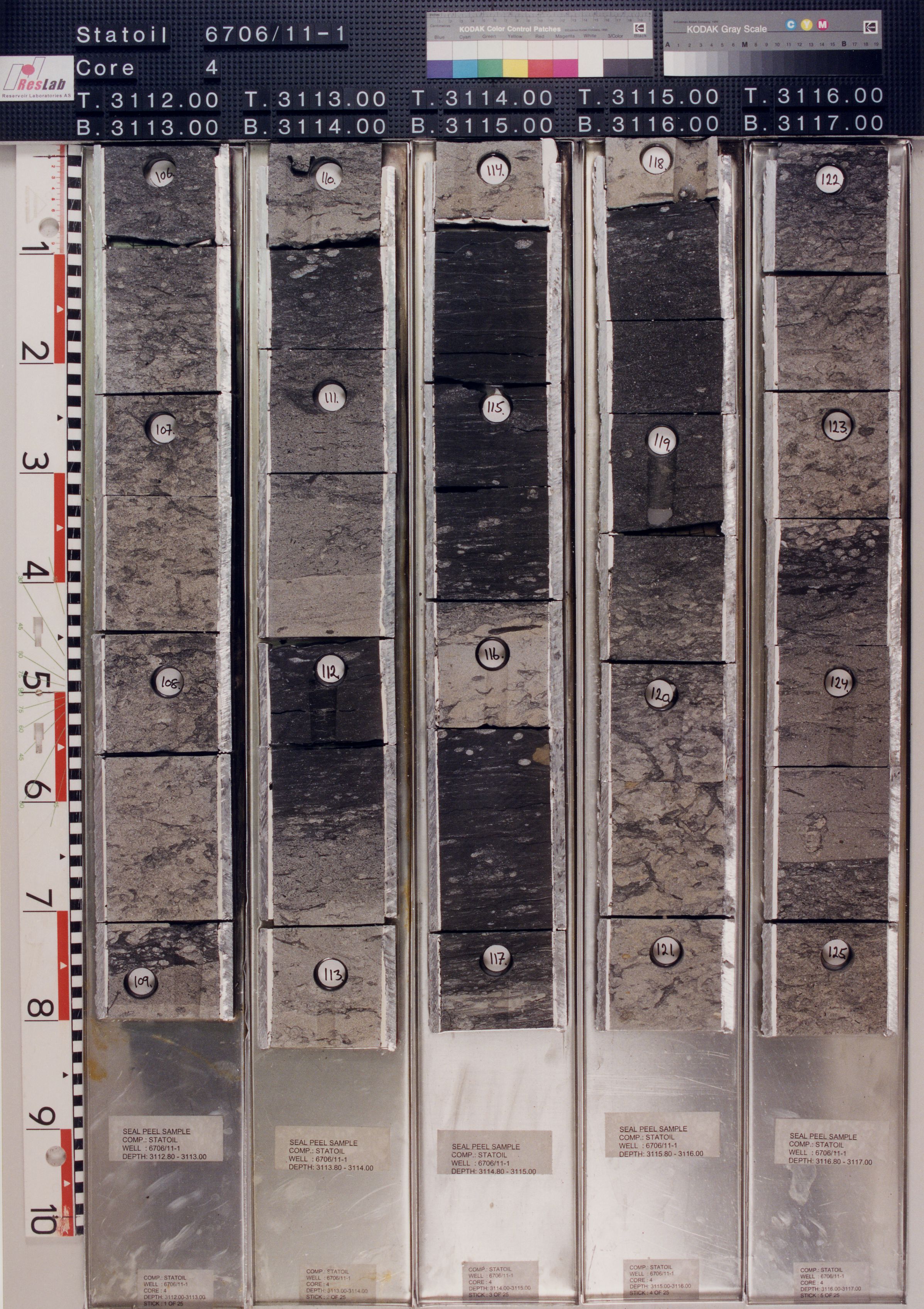
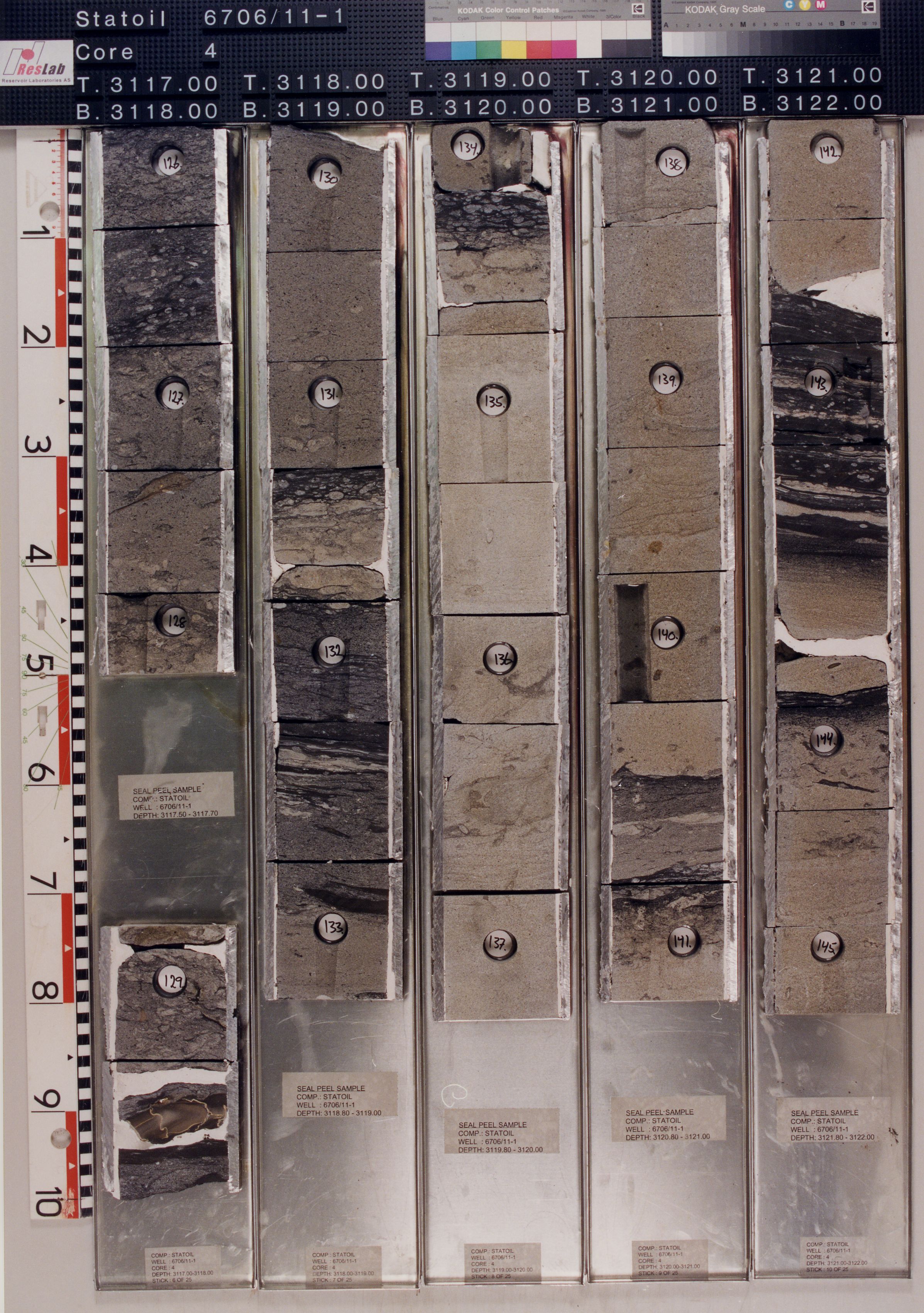
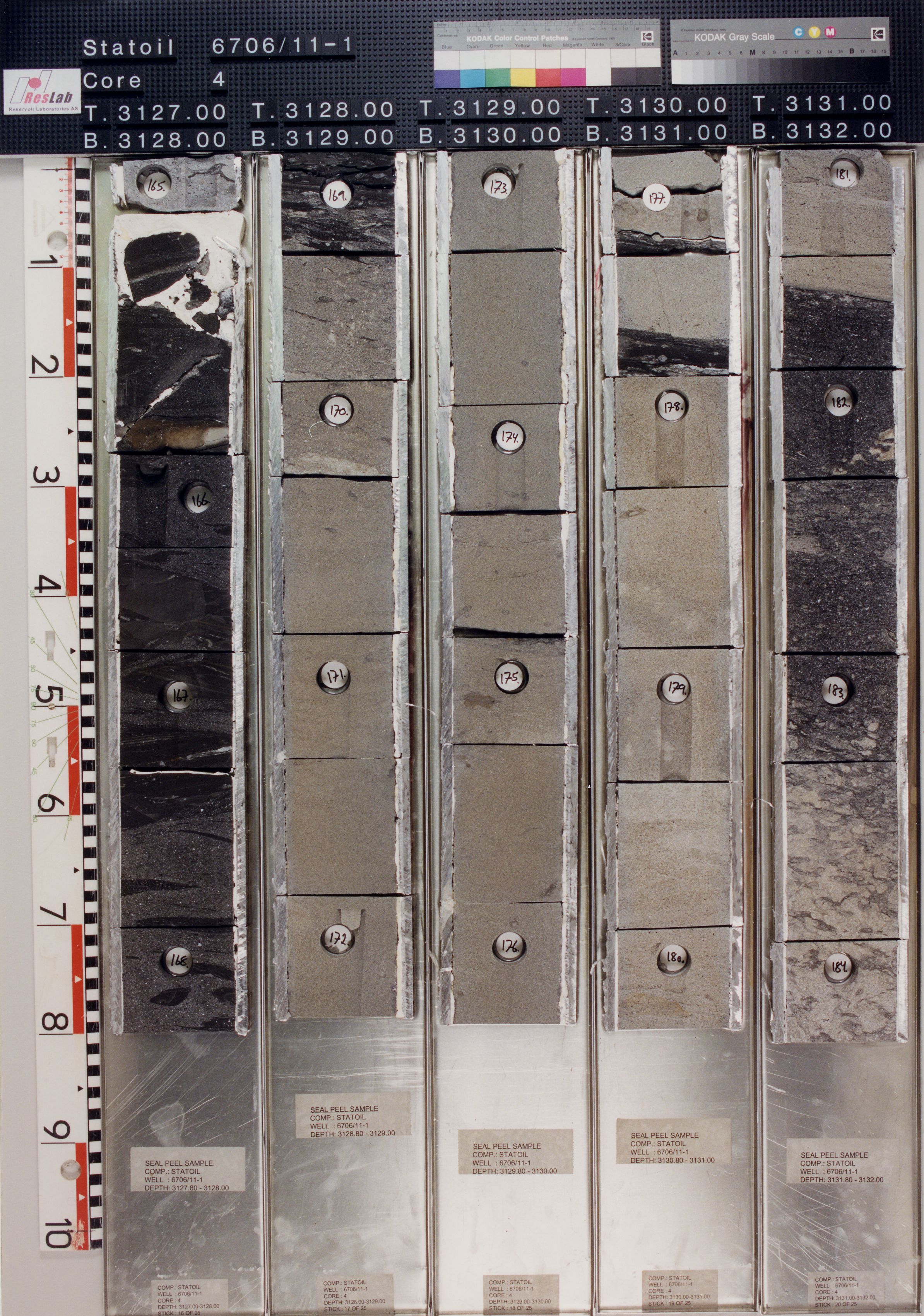
In wells 6607/5-1 and 6607/5-2 on the Utgard High and 6605/8-1 on the Fles North structure, time equivalent mudstones of the Kvitnos Formation are developed and provide an easterly and southern limit on the members distribution based on the available released well data. This distribution of the Tumler Member is more restricted than the overlying Spekkhogger Member where sandstones are present in well 6607/5-2, on the westerly flank of the Utgard High. The westerly limit of the member is undefined since the time equivalent section is below the well TD in well 6704/12-1, drilled on the Gjallar Ridge.Reference well 6706/11-1: 9 slides from core samples (cores#3 and #4) covering the upper part of the Tumler Member over the interval 3108m – 3136m and 11 slides from ditch cuttings samples between 3146m – 3461m deposited at the NPD (RRI preparations).
The deepest core (core#10) cut in the extensive coring programme of the Nyk High well 6707/10-1 recovered sandstones and minor mudstones of the (new) Tumler Member. These together with those of the overlying Spekkhogger Member (new herein) were collectively described by Kittilsen et al. (1999) as part of their ‘Lysing Formation’.
Reference well 6706/11-1: Cores#3 and #4 between 3107.5mMD - 3136.65mMDRKB.
Occurrences of formation tops in wells
Well name: 6707/10-1
WGS84 coordinates: N 67°04'07.85, E 07°00'36.51 (figure 2)
UTM coordinates: 7440629.70 N 413490.42 E
UTM zone: 32
Drilling operator name: BP Norway Ltd.
Completion date: 23.07.1997
Status: P & A
Interval of type section (m) & thickness in type well (m):
4241m-3939m and 302m thickness.
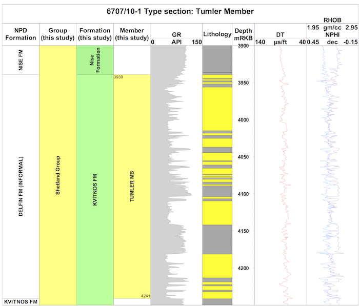
Logs of the type well 6707/10-1 (click to enlarge)
Well name: 6706/11-1
WGS84 coordinates: N 67°04'24.77, E 06°27'47.70 (figure 2)
UTM coordinates: 7442018.41 N 389745.19 E
UTM zone: 32
Drilling operator name: Den norske stats oljeselskap a.s.
Completion date: 22.03.1998
Status: P & A
Interval of reference section (m) & thickness in reference well (m):
3469m - 3101m and 368m thickness.
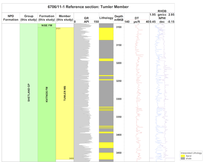
Logs of the type well 6706/11-1 (click to enlarge)
In the type well 6707/10-1, the top of the Tumler Member is taken at a downward change below a thick interval of mudstones within the lowermost part of the Nise Formation into an interbedded sequence of sandstones and mudstones. The change is transitional in the type well 6707/10-1 at 3939m MD RKB, and the sandstone rich section is slightly deeper in the section at 3956mMD. The upper boundary is therefore marked by a decrease in gamma-ray and density log values and an increase in sonic velocities.
In the reference well 6706/11-1, the upper boundary is marked by an abrupt shift and marked decrease in gamma-ray values, presumably in response to rapid abandonment of the sand system.In the type well 6707/10-1, the Tumler Member is characterised by at least three discrete sandstone units with blocky log profiles. The sandstone beds vary from approximately 5- 15m thickness. The mudstones generally form thin interbeds with the sandstones or more infrequently as discrete units with minor sandstone interbeds up to 15m thick. In the reference well 6706/11-1, the Tumler Member is mud-prone and characterised by a more finely serrate gamma-ray log profile although sandstone beds are more significant in the uppermost part.
The Tumler Member lies within the Santonian stage, being above the dinocyst markers LCO Heterosphaeridium difficile and LCO Chatangiella ‘spinosa’.
The upper boundary is developed below the LO Spongodinium cristatum. Planktonic foraminifera are generally absent in this member although the Santonian marker Whiteinella baltica is present in the overlying mudstones in association with the calcareous benthonic foraminifera Gavelinella-Eponides spp. and radiolarians. Probable reworking of early Santonian (or older) palynomorphs in association with recycled Cenomanian taxa was recorded in the reference well 6706/11-1.In the type well 6707/10-1, core #10 was taken within the Tumler Member as part of the extensive coring programme undertaken of the overlying Spekkhogger Member; the results were documented by Kittilsen et al. (1999). These authors describe the whole sedimentary package collectively as being deposited mainly by episodic high density turbidity currents or by linked debris flows, which evolved from the tails of the turbidite flows within a large scale submarine fan complex. Although not specific to any particular cored interval, Kittilsen et al. (1999) observed that there was little evidence of erosion of the turbidite sandstones into the background mudstones, suggesting the turbidite flows were largely unconstrained in this part of the submarine fan, and predicted them to occur as laterally extensive ‘sheet sands’. The subordinate, sand laminated mudstones and bioturbated background mudstones were considered to be of turbidity or hemipelagic origin. These mudstones in core yield a low diversity, deep water agglutinated foraminifera micro fauna (DWAF): The assemblage is dominated by simple tubular forms, and suggests a deep marine, bathyal paleoenvironment with poorly oxygenated bottom conditions.
Gradstein, F., Kaminski, M.A. and Agterberg, F.P. 1999. Biostratigraphy and paleoceanography of the Cretaceous seaway between Norway and Greenland. Earth-Science Reviews, 46, 27-98.
Kittilsen, J. E., Olsen, R.R., Marten, R. F., Hansen, E.K. and Hollingworth, R.R. 1999. The first deepwater well in Norway and its implications for the Upper Cretaceous Play, Vøring Basin. In: Fleet, A.J. and Boldy, S.A.R. (eds) Petroleum Geology of Northwest Europe: Proceedings of the 5th Conference, Petroleum Geology 1986 Ltd. Geological Society, London, 1, 275- 280.
Lien, T. 2005. From Rifting to drifting: effects on the development of deep-water hydrocarbon reservoirs in a passive margin setting, Norwegian Sea. Norwegian Journal of Geology, 85 319-332.
Morton, A.C. and Grant, S. 1988. Cretaceous depositional systems in the Norwegian Sea; heavy mineral constraints. AAPG Bulletin, 82(2), 274-290.
Vergara, L., Wreglesworth, I., Trayfoot, M., Richardsen, G. 2001. The distribution of
Cretaceous and Paleocene deep-water reservoirs in the Norwegian Sea basins. Petroleum
Geoscience, 7, 395-408.
| home | previous page |