Egga Member
updated to follow: Stratigraphic Guide to the Rogaland Group, Norwegian North Sea. Harald Brunstad, Felix M. Gradstein, Jan Erik Lie, Øyvind Hammer, Dirk Munsterman, Gabi Ogg, and Michelle Hollerbach. Newsletter on Stratigraphy, vol 46/2 pp137-286, 2013.
Rogaland Group, Våle Formation
(south of 62°), Tang Formation (north of 62°).
Unit definition
The Egga Member comprises sandstones of intra Våle Formation and
lower Tang Formation found
along the northeasternmost parts of the North Sea Basin and along the Mid Norwegian Shelf.
South of 62°N the Egga Member is included in the Våle Formation and north of 62°N it is
included in the fine grained siliciclastics of the Tang Formation (no carbonate content,
hence not Våle Formation).
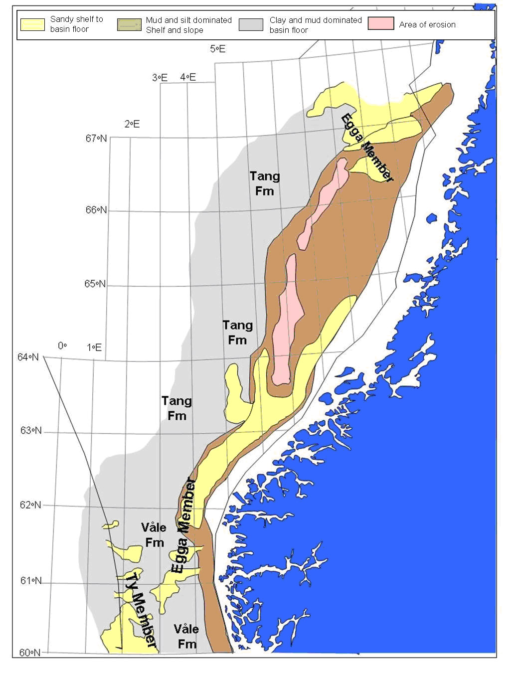
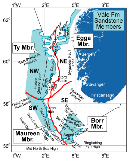 Fig 1: Location map of the Members of the Våle Formation.
 |
Name
The name Egga has been informally used since 1990, when hydrocarbon reservoir sands assigned
this name were first penetrated by Norsk Hydro in Norwegian well
6205/3-1. The name Egga
first appeared in the literature in an extended abstract published by Gjelberg et al. (1999).
The name is commonly attached to the Ormen Lange gas field in the Møre Basin where the Egga
sandstones form the main reservoir (Gjelberg et al., 2001, 2005; Mцller et al., 2004). The
unit was assigned by Gjelberg et al. (1999) to an upper member of the Våle Formation (see
below). The Egga lithostratigraphic unit was not formally defined in these three studies.
Derivatio nominis
In the final Norwegian 6205/3-1 well report (unpublished) the unit is named after the
Eggakant shelf break to the east of the Møre Basin.
Type well
Norwegian well
6305/5-1 (New, Fig. 60). Depth
interval 2718- 2770.4 m, 52.4 m thick.
Coordinates N 63°32'27.50", E 5°20'14.90"; UTM coordinates 7048160.15 N - 616189.14 E.
Although Gjelberg et al. (1999, 2001) did not select a type well it is evident that this well
is best suited as type section for the Egga Member. Information about the lithology,
mineralogy, cores, biostratigraphy, sedimentology, wireline logs and depositional setting is
provided by Gjelberg et al. (1999, 2001) and Mцller et al. (2004).
Cores 1-3 are available at the NPD, as well as cuttings for the interval 2718-2770.4 m.
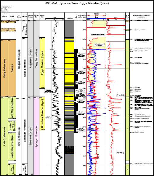
Egga Member in type section. Click to enlarge.
Published core description 6305/5-1, by Gjelberg (PDF)
Reference wells
Well
6205/3-1 (New). Depth interval
1317-1482 m, 165m thick. Coordinates N 62°57'08.62", E
5°56'38.11"; UTM coordinates: 6983872.90 N, 649328.84 E.
This well was selected as the primary reference section because with 165 m of the Egga Member
it exhibits the best development of the unit drilled to date. The well is drilled in the
Slørebotn Subbasin of the Møre Basin.
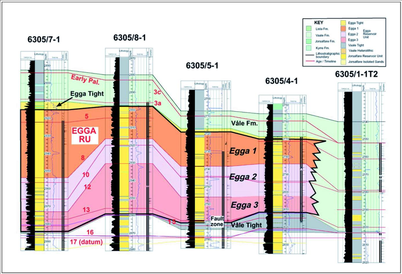
Well 6305/8-1 (New, Fig. 60),
Depth interval 2898 m -2959 m, 61 m thick. Coordinates N 63°28'34.70",
E 5°24'14.40"; UTM coordinates 704080.68 N, 619765.5 E.
This second reference well provides complete core coverage of the Egga Member and illustrates
lithostratigraphic details of its upper boundary within the Tang Formation.
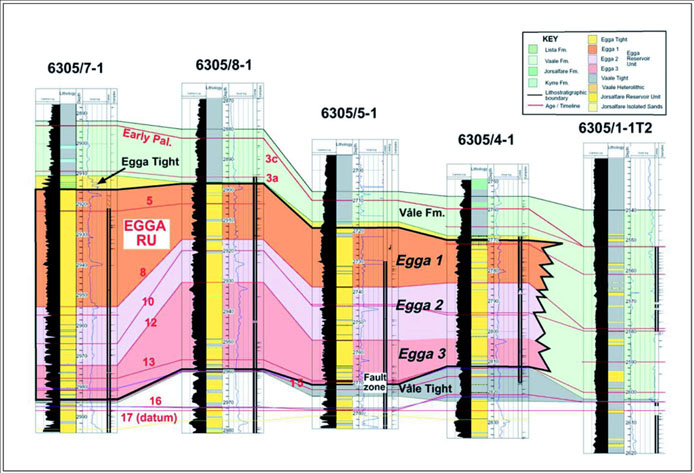
Fig. 60. Well correlation for the Egga Member Møre Basin area. From Møller et al, 2004.
|
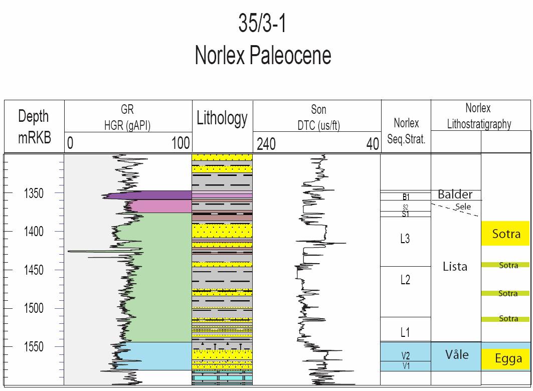
Well 35/3-1 (New, Fig. 61). Depth
interval 1580-1556 m, thickness 44 m. Coordinates N 61°50'41.89" E 03°43'41.36". UTM
coordinates 6857289.00 N 538333.83 E.
This well has been chosen to represent the Egga Member south of 62°N. No cores have been
taken from this well.

Fig. 61. Well 35/3-1 composite log Rogaland Group. Stratigraphic position of the Egga
Member is outlined in stratigraphic column to the right.
|
Composition
According to Gjelberg et al. (1999; 2001) and Mцller et al. (2004) the unit is sandstone
dominated with some greenish colour and strongly bioturbated texture. The sandstones are
texturally mature, medium to coarse grained, and alternate with thin, fining upward sandy
mudstones.
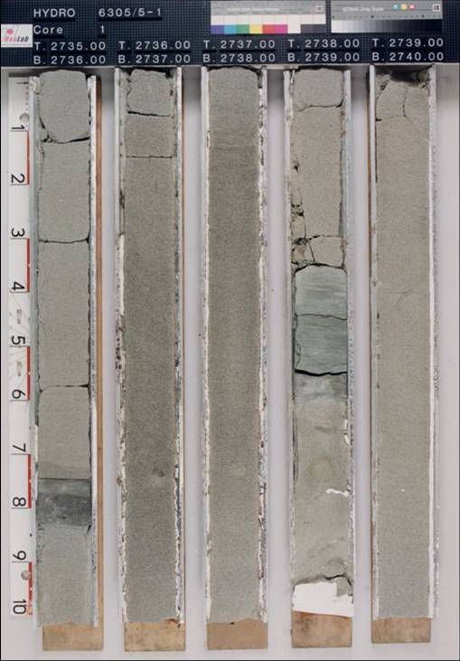
Core photograph example for well
6305/5-1 is shown in Fig 62. Core
photographs for 6305/8-1
are available from the NPDs web-site for the interval 2895-2988 m; this includes the
underlying Jorsalfare Formation:
http://www.npd.no/engelsk/cwi/pbl/en/well/all/4109.htm

Fig. 62. Core photo from the Egga Member well 6305/5-1. Well drilled by Norsk Hydro. From
NPD Fact Pages at http://www.npd.no.
|
Wireline log characterization
Lower boundary
From the core descriptions of the type well 6305/5-1 the lower boundary is a sharp contact
between shales referred to as "lower mudstone unit" and the overlying sandstones of the Egga
Member. Across the boundary, hemipelagic black, virtually non-bioturbated mudstones change to
greenish, strongly bioturbated sands that become dominant in the Egga Member (Gjelberg et al.
2001). The lower mudstone unit is ascribed to the
Våle Formation by Gjelberg et al. (2001),
but we note that the Våle Formation commonly has carbonate content, whereas the Egga
enveloping mudstone is purely siliciclastic, and is better referred to as the
Tang Formation.
In the 6205/3-1 and 6305/8-1 reference sections the contacts on wireline logs appear to be
less sharp and more gradational.
Upper boundary
The upper boundary is drawn at 2718 m in the type well (Gjelberg et al. 2001), corresponding
to the top of the sandstone section overlain by shales of the Våle/Tang Formation in which
the Egga Member is confined.
Thickness
In well 6305/5-1, the Egga Member is 52.4 m thick; in well 6205/3-1 it attains a thickness of
up to 165 m. Values close to 100-150 m appear to be typical along the eastern margin of the
Møre Basin (wells 6305/12-1 and 6306/10-1). In the Ormen Lange gas field area itself, the
unit varies in thickness from 41.5 - 69m.
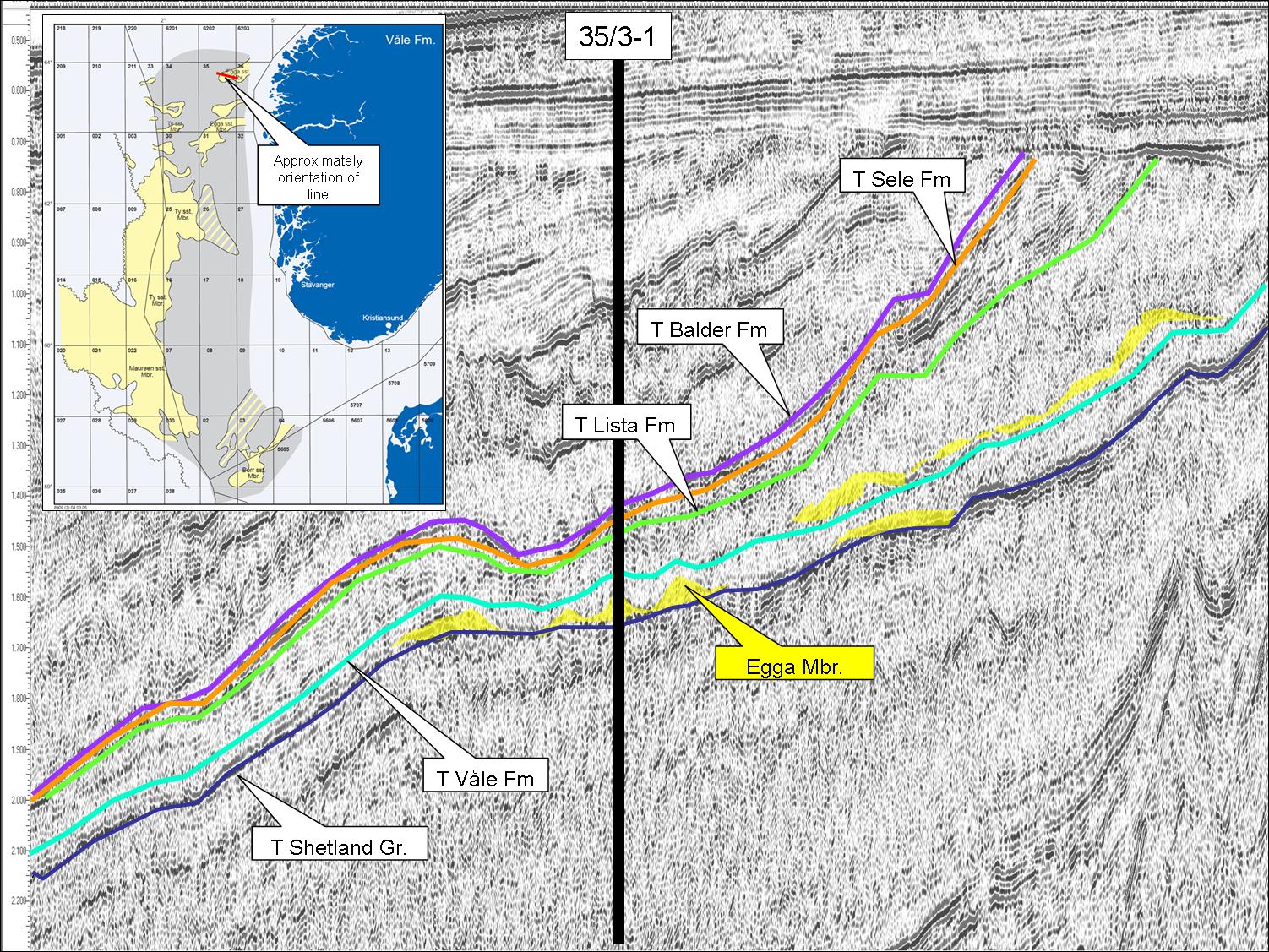
Seismic characterization
The Egga Member south of 62°N is seen to have a mounded to lenticular shape on seismic
sections. The sandstones often have little seismic contrast to the sometimes calcareous
claystones and mudstones of the Våle Formation above and below it. This sometimes makes it
difficult to map the exact top and base of the sandstones. Thus interpretation of the
presence of Egga sandstones is often related to thickening of the stratigraphic interval
between mappable shale events, such as maximum flooding surfaces or sequence boundaries. A
seismic cross section through blocks 35/2 and 35/3 is shown in Fig. 63.
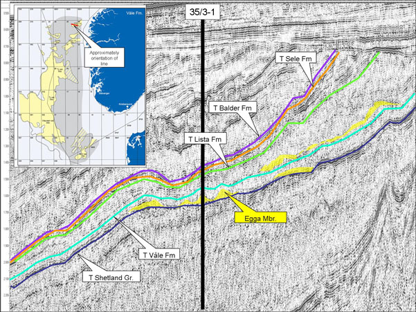
Fig. 63. Seismic WE Cross Section through well 35/3-1, showing inferred presence of Egga
Member.
|
Age
The Egga Member sandstones are of Danian to Early Selandian age (Vergara et al., 2001).
Biostratigraphy
The deep marine shale encompassing the reservoir interval of the type well 6305/5-1 of the
Egga Member is rich in shelly and organic walled microfossils of early Paleocene to late and
early Maastrichtian (reworked) age, as listed below from younger to older strata.
Shelly microfossils
In the Type well the following shelly microfossils are found:
2620 - 2744.65m: Cenodiscus lenticularis LO, C. hyphalus, rare Subbotina
pseudobulloides,
rare Planorotalites compressus, Cibicidoides beccariformis.
2779.15m - 2810.40m: Arenobulimina spp., Globigerinelloides asper,
Heterohelix striata,
Abathomphalus mayaroensis, Racemiguembelina fructicosa, Contusotruncana
contusa, and
Rugoglobigerina rugosa, Pseudotextularia elegans, Bolivinoides
incrassata, Globotruncanella havanensis.
2805.10 - 2810.40m: Coarse agglutinated benthic foraminifers LCO, Bolivinoides incrassata
incrassata, Reussella szajnochae.
27 palynological slides from this well covering the Egga Member interval are available
from the NPD. No thin sections were reported.
Organic walled microfossils
In the Type well the following organic walled microfossils are found:
2650.00 - 2700.00m: P. pyrophorum LAO, I. ?viborgense LO, C. diebeli
LO
2720.00 - 2779.15m: A. reticulata, S. 'magnifica', S. delitiense,
S. inornata, T. fragile.
2779.40 - 2806.15m: P. grallator
2810.40-1816.15m: T. utinensis, A. acutulum
Based on the combined microfossil content from 2718 - 2770m, the Egga Member is of Early
Paleocene (Danian) age.
Correlation and subdivision
Correlation of the Egga Member south of 62°N follows the same stratigraphic subdivision
as with the Ty Member, and relates to its position relative to the Våle
subzone where it
occurs, e.g. Egga V1 Sub-member for occurrence in lower parts and Egga V2 Sub-member for an
occurrence in upper parts of the Våle Formation.
Geographical distribution
The Egga Member type area is the east Møre Margin, including the Ormen Lange dome and the
Slørebotn Subbasin, where it is a proven gas reservoir or an exploration target. It extends
southwards into the northern North Sea (Fig. 64), Måløy and Uer Terraces (Quadrant 35),
although the distribution in that area is patchy. An age equivalent sandstone unit is
developed in the Vestfjorden and Træna Basins, along the northerwestern part of the Norwegian
continental margin. There are no well penetrations of the unit in the Vøring Basin, and the
unit is absent in the Halten and Dønna Terraces, as well as on the Trøndelag Platform.
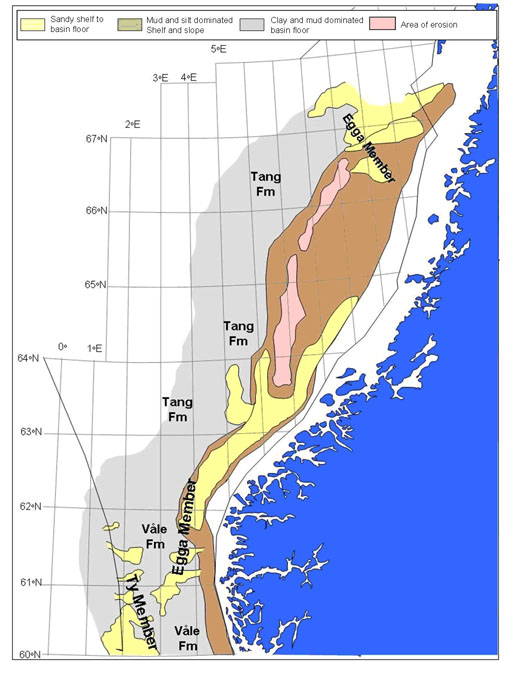
Fig. 64. Map of the Egga north and south of 62°N.
|
Depositional environment
The Egga Member sands are interpreted to infill shallow, intra slope basins or depressions in
the Slørebotn Sub basin, or laterally bypassing and depositing into the deeper parts of the
Møre Basin, where they accumulated as thick amalgamated turbidites in a basin floor setting
in the Ormen Lange area (Gjelberg et al., 2001; Mцller et al., 2004).
See also Sømme et al. (2009) - link below.
References
Sømme, T.O., Martinsen, O.J. & Thurmond, J.B. 2009. Reconstructing
morphological and depositional characteristics in subsurface sedimentary
systems: An example from the Maastrichtian-Danian Ormen Lange System,
Møre Basin, Norwegian Sea.
[PDF]