Grid Member
Hordaland Group,
Horda Formation
Name
English/ Norwegian
Grid Member / Gridleddet
Derivatio nominis
Named after a female giant in Norse mythology, who was one of the wives of Odin.
Original definition
Isaksen, D. & Tonstad, K. 1989. A revised Cretaceous and Tertiary lithostratigraphic
nomenclature for the Norwegian North Sea. NPD-Bulletin, No. 5, page 49.
Lithology
The formation consists of sandstones with interbeds of claystone and siltstone.
The sandstones often have a massive, "blocky", appearance as illustrated by
type well
15/3-3
(Fig. ). Individual sandstone beds show little or no evidence of fining
upwards or coarsening upwards. The sandstones are very fine to fine,
sometimes medium to coarse.
Sorting is generally moderate to good. Traces of mica, pyrite, glauconite and
fossil fragments are common. A higher argillaceous content is found in distal
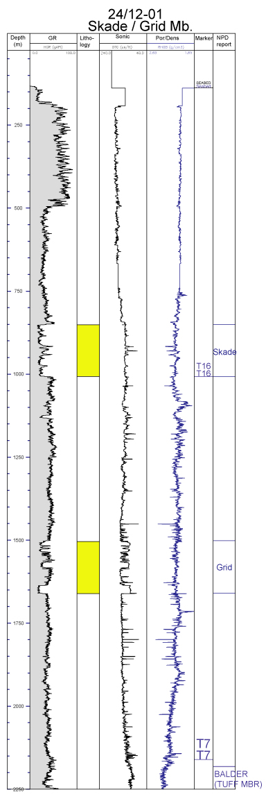
areas. Well
24/12-1
illustrates the interfingering of thicker claystone units of the Hordaland
Group with the Grid Member.
Thickness
The formation is 158 m in well
24/12-1
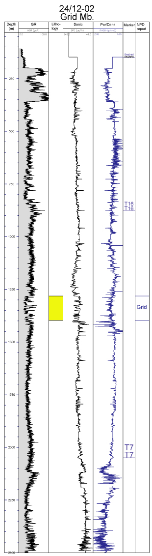
and 115 m in well
24/12-2
.
Geographical distribution
The sandstones were probably derived from the East Shetland Platform and the
formation is recognised in the Viking Graben area between 58°30'N and approximately
60°30'N. A depocentre lies in Norwegian block 15/3 where the formation
reaches a thickness of nearly 400 m. It thins eastwards and is not penetrated by wells on
the Utsira High. It has been identified in some wells in the Oseberg area. In the Viking
Graben north of 61° N, several sandstone bodies occur in the Hordaland Group at the
same level, but it is uncertain whether they belong to the Grid Member.
Type well
Well name
15/3-3
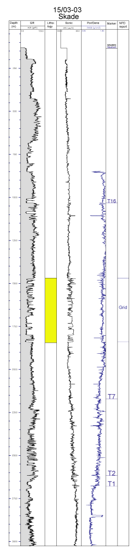
click to enlarge
Interval of type section (m)
From 1840 to 1470 m in the type well 15/3-3.
Reference wells
Well name
Norwegian wells
24/12-1
and
24/12-2
.
24/12-1:
Interval of reference section (m)
24/12-1: 1660-1502 m.
24/12-2: 1397-1282 m.
Boundaries
Lower boundary (basal stratotype)
The lower boundary shows a decrease in gamma-ray response and an increase in
velocity from the Hordaland Group into the sandstones of the Grid Member).
Upper boundary (characteristics)
The upper boundary is characterised by an increase in gamma-ray readings and a
decrease in velocity from the sandstones of the Grid Member into the overlying
claystones of the Hordaland Group.
Age
Middle to Late Eocene, but wells
25/6-1
and
24/12-2
have given an Early Oligocene age.
Depositional environment
The formation is thought to have been deposited in an open marine environment during
a regressive period (Isaksen & Tonstad, 1989).
Remarks
The member comprises a series of sand bodies which interfinger with claystones.
There is a considerable increase in thickness from less than 200 m north of 59° N (e.g.
wells 24/12-1 and 24/12-2) to nearly 400 m south of 59° N (e.g. well 15/3-3). This is
not due to a general increase in thickness, but rather to sand deposition having started
earlier in the south. This could give grounds for erecting two formal units, a lower
one confined to the area south of 59° N and probably of Middle Eocene age, and an
upper one. In some areas the lower unit is separated from the upper one by a sequence
of claystones which is referred to informally as the Belton member in the UK
sector. However, lithological uniformity renders such subdivision impractical at present.