 |
|
|
|
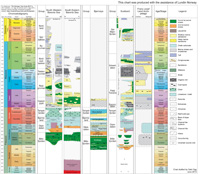
Barents Sea lithostratigraphic chart (click for full size)
| Group | Formation | Type well | Interval | Location | Reference well | Interval | Location |
| Nordland | 7119/12-1 | 465-225 m | N 71°06'08.00 E 19°47'40.29 | ||||
| Sotbakken | Torsk | 7119/12-1 | 810-465 m | N 71°06'08.00 E 19°47'40.29 | 7120/12-1 | 725-462 m | N 71°06'48.7 E 20°45'20.1 |
| Nygrunnen | Kviting | 7120/12-1 | 742-725 m | N 71°06'48.7 E 20°45'20.1 | 7121/5-1 | 1036-1005 m | N 71°35'54.88 E 21°24'21.78 |
| Kveite | 7119/12-1 | 1059-810 m | N 71°06'08.00 E 19°47'40.29 | 7119/7-1 | 2529-1331.5 m | N 71°23'42.40 E 19°15'18.43 | |
| Nordvestbanken | Knurr | 7119/12-1 | 2497-2441 m | N 71°06'08.00 E 19°47'40.29 | 7120/12-1 | 1660-1375 m | N 71°06'48.7 E 20°45'20.1 |
| Kolje | 7119/12-1 | 2441-2004 m | N 71°06'08.00 E 19°47'40.29 | 7120/12-1 | 1375-1272 m | N 71°06'48.7 E 20°45'20.1 | |
| Kolmule | 7119/12-1 | 2004-1059 m | N 71°06'08.00 E 19°47'40.29 | 7120/12-1 | 1272-742 m | N 71°06'48.7 E 20°45'20.1 | |
| Teistengrunnen | Fuglen | 7120/12-1 | 2047-2019 m | N 71°06'48.7 E 20°45'20.1 | 7119/12-1 | 2658-2610 m | N 71°06'08.00 E 19°47'40.29 |
| Hekkingen | 7120/12-1 | 2019-1660 m | N 71°06'48.7 E 20°45'20.1 | 7119/12-1 | 2610-2497 m | N 71°06'08.00 E 19°47'40.29 | |
| Realgrunnen | Stø | 7121/5-1 | 2445-2368 m | N 71°35'54.88 E 21°24'21.78 | 7119/12-2 | 1517-1372 m | N 71°00'51.81 E 19°58'20.81 |
| Nordmela | 7121/5-1 | 2507-2445 m | N 71°35'54.88 E 21°24'21.78 | 7119/12-2 | 1719-1517 m | N 71°00'51.81 E 19°58'20.81 | |
| Tubåen | 7121/5-1 | 2572-2507 m | N 71°35'54.88 E 21°24'21.78 | 7120/12-1 | 2337-2250 m | N 71°06'48.7 E 20°45'20.1 | |
| Fruholmen | 7121/5-1 | 2793-2572 m | N 71°35'54.88 E 21°24'21.78 | 7120/12-1 | 2535-2337 m | N 71°06'48.7 E 20°45'20.1 | |
| Ingøydjupet | Snadd | 7120/12-2 | 2927-2354 m | N 70°07'30.03 E 20°48'19.00 | 7120/12-1 | 3474-2535 m | N 71°06'48.7 E 20°45'20.1 |
| 7120/9-2 | 3962-2552 m | N 71°29'40.81 E 20°42'05.38 | |||||
| Kobbe | 7120/12-2 | 3095-2927 m | N 70°07'30.03 E 20°48'19.00 | 7120/9-2 | 4245-3962 m | N 71°29'40.81 E 20°42'05.38 | |
| Klappmyss | 7120/12-2 | 3552-3095 m | N 70°07'30.03 E 20°48'19.00 | 7120/9-2 | 4806-4245 m | N 71°29'40.81 E 20°42'05.38 | |
| Havert | 7120/12-2 | 3657-3552 m | N 70°07'30.03 E 20°48'19.00 | 7120/9-2 | 4956-4806 m | N 71°29'40.81 E 20°42'05.38 |
Gradstein, F., Davydov, V., Dons, C. & Pedersen, J.H. 2012. Stratigraphy and paleo-environment of Brucebye Beds, basal Tyrrellfjellet Member, Svalbard. [Poster PDF, 87 Mb
Larssen, G.B., Elvebakk, G., Henriksen, L.B., Kristensen, S.-E., Nilsson, I., Samuelsberg, T.J., Svånå, T.A., Stemmerik, L. & Worsley, D. 2002. Upper Palaeozoic lithostratigraphy of the Southern Norwegian Barents Sea. [PDF] [INTERACTIVE HTML]
Stemmerik, L. & Worsley, D. 2005. 30 years on - Arctic Upper Palaeozoic stratigraphy, depositional evolution and hydrocarbon prospectivity. [PDF]
Smelror, M. 1987. Bathonian and Callovian (Middle Jurassic) dinoflagellate cysts and acritarchs from Franz Josef Land, Arctic Soviet. [PDF]
Smelror, M., Mørk, A., Monteil, E., Rutledge, D. & Leereveld, H. 1998. The Klippfisk Formation - a new lithostratigraphic unit of Lower Cretaceous platform carbonates on the Western Barents Shelf. [PDF]
Worsley, D. 2008. The post-Caledonian development of Svalbard and the western Barents Sea. [PDF]
Worsley, D., Agdestein, T., Gjelberg, J.G., Kirkemo, K., Mørk, A., Nilsson, I., Olaussen, S., Steel, R.J. & Stemmerik, L. 2001. The geological evolution of Bjørnøya, Arctic Norway: implications for the Barents Shelf. [PDF]
| home | previous page |