|
|
|
|
QUATERNARY VOLCANIC AND SUBVOLCANIC ROCKS
from: Dallmann. W.K. (ed.). Svalbard lithostratigraphic lexicon
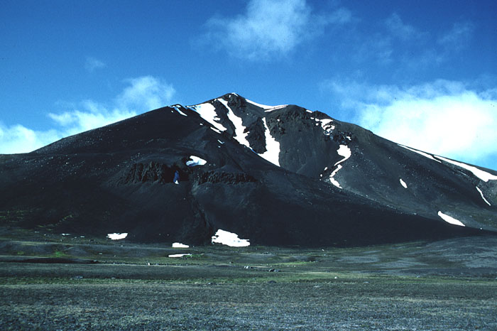
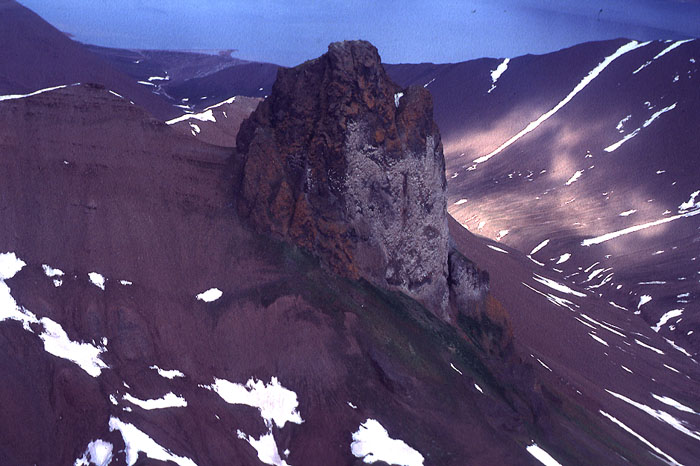
5.1 General remarks 5.2 Lexicon of lithostratigraphic units 5.1 General remarksVolcanic activity of Quaternary age occurred in northwestern Spitsbergen. Remains of three volcanic features are preserved on, or in the vicinity of, the Breibogen Fault (Fig. 1-05), a major north-south directed fault separating Devonian sediments from metamorphic Caledonian basement rocks. Movements along this fault date back to at least the Devonian.One of the features, Sverrefjellet, still is reminiscent of a volcano, although it has been reshaped by glacial activity. It consists mainly of pyroclastics. Halvdanpiggen is the remains of a volcanic pipe and forms a prominent basalt neck rising above red Devonian sandstones. Sigurdfjellet shows a prominent ridge composed of basaltic pyroclastics (Fig. 4-07). The volcanic and subvolcanic rocks are classified as offridge alkali basalts, with a considerable amount of xenoliths derived from deep crustal and upper mantle regimes. The age of the two first centres is probably between 100,000 and 250,000 years, while the third may be older (Skjelkvåle et al. 1989). Thermal springs situated close to Sverrefjellet (Trollkjeldane, Jotunkjeldane), with water temperatures reaching 14-28°C witness to the continuously high geothermal gradient in the area, which is related to the Yermak hot spot north of Spitsbergen (Fig. 1-02). No stratigraphic nomenclature for these rocks has been published. A collective name, Bockfjorden Volcanic Complex, is proposed here, while the individual occurrences should conveniently be addressed by their geographical names Sverrefjellet, Halvdanpiggen and Sigurdfjellet. Back on top 5.2 Lexicon of lithostratigraphic unitsBOCKFJORDEN VOLCANIC COMPLEX (Q-01)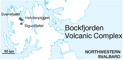
DISTRIBUTION shown on fig. 4-07 STATUS OF UNIT: Formal FIRST USE OF NAME: Here CURRENT DEFINITION: Skjelkvåle et al. 1989 SYNONYM(S) AND REFERENCE(S): None ORIGIN OF NAME: Bockfjorden: A fiord in northwestern Spitsbergen, a bifurcation of Woodfjorden TYPE AREA: Bockfjorden and its environments, northwestern Spitsbergen STRUCTURAL SETTING: Breibogen Fault and associated structures VOLCANIC AGE: Pleistocene (see individual eruptive centres) OVERLYING UNIT(S): None HOST UNIT(S): Andrйe Land Group (Devonian), Pre-Old Red SUPERIOR UNIT: None OTHER USE OF NAME: Bockfjorden anticline (Gee 1972): A basement anticline paralleling Bockfjorden, west of the Breibogen Fault. The name is informal and little used. MAIN LITHOLOGIES: Basaltic pyroclastics and lava DESCRIPTION: The complex consists of three separate eruptive centres (Sverrefjellet, Halvdanpiggen and Sigurdfjellet) within a distance of 20 km. The centres show varying volcanic and subvolcanic features and are preserved at different erosional levels, all from the eroded remains of stratovolcano to subvolcanic vents. A wide variety of upper mantle and lower crustal xenoliths comprise about 15-20 vol.% of the volcanic centres (Amundsen 1987; Amundsen et al. 1987, 1988). The petrographic composition of the basalts is alkaline, with phenocrysts of olivine, titanaugite and rare plagioclase together with xenocrysts, embedded in a fine-grained matrix of euhedral olivine, titanaugite, plagioclase laths, titanomagnetite and basaltic glass. The chemical composition indicates that magmas were primitive and that some may be primary. The magmas ascended rapidly after the entrainment of the xenoliths, and no magma chamber developed. The magmas are typical of intraplate, alkaline volcanism. Geothermobarometry calculations on xenoliths from the three eruptive centres define a very high geotherm consistent with their location near the Yermak hot spot (Fig. 1-02). The crust-mantle boundary is calculated to be at a depth of 27 km. (Skjelkvåle et al. 1989) SVERREFJELLET VOLCANO (Q-02) DISTRIBUTION shown on fig. 4-07 STATUS OF UNIT: Formal FIRST USE OF NAME: Hoel & Holtedahl 1911: Le volcan de la Baie Bock [Mt. Sverre] CURRENT DESCRIPTION: Skjelkvåle et al. 1989 SYNONYM(S) AND REFERENCE(S): None ORIGIN OF NAME: Sverrefjellet: The ruin of a volcano west of Bockfjorden, northwestern Spitsbergen, named after an Old Norse king VOLCANIC AGE, REFERENCES AND DATING METHODS: Hoel & Holtedahl 1911: Post-glacial; morphological (mis)interpretation. Gjelsvik 1963: Partly subglacial; from the existence of pillow lavas. Burov & Murašsov 1964 (unpubl.): 0.01-0.2 Ma; geomorphological analysis. Halvorsen 1972: <0.7 Ma; palaeomagnetology. Burov & Zagruzina 1976: < 1 Ma; K-Ar radiometric age determination. Skjelkvåle et al. 1989: 0.1-0.25 Ma, comparative studies of glaciation episodes, erosion and morphology HOST UNIT(S): Pre-Old Red SUPERIOR UNIT: Bockfjorden Volcanic Complex OTHER USE OF NAME: None DIMENSIONS: Elevation above sea level: 20-506 m. Area: Subcircular, ca. 7 km2 (3 km across) MAIN LITHOLOGIES: Basaltic pyroclastics and lavas DESCRIPTION: The Sverrefjellet Volcano (Fig. 5-01) is the ruin of a stratovolcano constructed of primitive alkali basaltic pyroclastics (scoria, lapilli, bombs) with subordinate pahoehoe lavas rich in xenoliths derived from the upper mantle and lower crust. The occurrence of interbedded pillow lavas and pahoehoe flows indicates that the volcano grew concurrently with the rise of the surrounding glaciers. Glacial debris occurs on its flanks. Reworked material from the volcano forms marine terraces below the eastern slope at Bockfjorden at 5-60 m above sea level. Though reminiscent of a primary volcanic shape, the present outline of the mountain is the result of erosion. The surface is 80% covered with frost-weathered material, while 20% is made up of lava surfaces. Lava flows are 1-3 m thick and may form successions of up to 15 flows. Most seem to be derived from flank eruptions. A dike is exposed in an eroded valley side on the southeastern flank. At an elevation of 350-450 m, the main volcanic vent is exposed with a diameter of ca. 200 m. Its pyroclastic material is hydrothermally altered and shows up to 10 m high erosional pillars consisting of lava, outwardly grading into scoriaceous material. Some of the pillars contain hollow tubes interpreted as magma conduits. (Skjelkvåle et al. 1989) HALVDANPIGGEN ERUPTIVE CENTRE (Q-03) DISTRIBUTION shown on 4-07 STATUS OF UNIT: Formal FIRST USE OF NAME: Skjelkvåle et al. 1989 CURRENT DESCRIPTION: Skjelkvåle et al. 1989 SYNONYM(S) AND REFERENCE(S): None ORIGIN OF NAME: Halvdanpiggen (transl. “The Peak of Halvdan”): A volcanic pipe in Riisefjella east of Bockfjorden, northwestern Spitsbergen, named after an Old Norse king. The associated volcanic features Olavstårnet (transl. “The Tower of Olav”) and Haraldknattane (transl. “The Humps of Harald”) are also named after ancient kings. VOLCANIC AGE, REFERENCES AND DATING METHODS: Halvorsen 1972: >0.7 Ma; palaeomagnetology. Skjelkvåle et al. 1989: Older than Sverrefjellet; concluded from its deeper erosion and greater degree of weathering HOST UNIT(S): Andrée Land Group (Devonian) SUPERIOR UNIT: Bockfjorden Volcanic Complex OTHER USE OF NAME: None DIMENSIONS: Elevation above sea level: 580-834 m. Area: Subcircular, 0.012 km2 (400 m across) MAIN LITHOLOGIES: Basaltic pyroclastic breccia DESCRIPTION: The Halvdanpiggen Eruptive Centre (Fig. 5-02) is a complex of vents and high-level intrusives in Halvdandalen (Riisefjella). The largest body is Halvdanpiggen itself, a volcanic neck 200 m across, consisting of a pyroclastic breccia of basaltic blocks and 60-70 % angular highpressure xenoliths. The central section of Halvdanpiggen is intruded by aphanitic, non-vesicular basalts weathering with a fanning columnar jointing. Small outcrops of pyroclastics and basalt around the neck suggest that the actual diameter of the vent is ca. 400 m. Halvdanpiggen is interpreted to be a complex, deeply eroded diatreme or volcanic conduit. Numerous associated satellite vents occur within a 2-km radius. Olavstårnet is a small neck, 5 m across and 5 m high, ca. 1 km southwest of Halvdanpiggen. It consists of basalt with radial, columnar jointing. Two dikes strike from the neck towards Halvdanpiggen. Haraldknattane occur 1.5-2 km east of Halvdanpiggen and comprise three small tuff-breccia vents at 485 m, 520 m and 700 m elevations. They consist of loosely consolidated breccia containing lava fragments, high-pressure xenoliths and Devonian host rock. The breccia is cut by two dikes, 10 m and 50 m long, and 0.2 m and 0.5 m thick, the longer terminating in a small volcanic neck. (Skjelkvåle et al. 1989) SIGURDFJELLET ERUPTIVE CENTRE (Q-04) DISTRIBUTION shown on 4-07 STATUS OF UNIT: Formal FIRST USE OF NAME: Skjelkvåle et al. 1989 CURRENT DESCRIPTION: Skjelkvåle et al. 1989 SYNONYM(S) AND REFERENCE(S): None ORIGIN OF NAME: Sigurdfjellet: A mountain ridge consisting of volcanic rocks at Vonbreen, northwestern Spitsbergen, named after an Old Norse king VOLCANIC AGE, REFERENCES AND DATING METHODS: Skjelkvåle et al. 1989: 0.1-0.25 Ma; indirectly from of morphology and degree of weathering in comparison with Sverrefjellet HOST UNIT(S): Andrée Land Group (Devonian), Pre-Old Red SUPERIOR UNIT: Bockfjorden Volcanic Complex OTHER USE OF NAME: None DIMENSIONS: Elevation above sea level: 910-1,162 m. Area: Elongate, 4.5 km long, 200-250 m wide MAIN LITHOLOGIES: Basaltic pyroclastics DESCRIPTION: The Sigurdfjellet Eruptive Centre is an elongate ridge on – although normal to – the Breibogen Fault. It cuts across the fault and overlies Devonian rocks to the east, and Proterozoic basement rocks to the west of it. The ridge consists of coarsely bedded pyroclastics (breccias, lapillistones, tuffs, bombs) penetrated by several smaller (5-10 m in diameter) explosion vents. One basalt neck, 2 m across, occurs on the top of the ridge on the eastern side. Pahoehoe lava flows occur locally at the southeastern end overlying Devonian. The occurrence is interpreted as a partially eroded diatreme or magma conduit. (Skjelkvåle et al. 1989) Back to top |